Discussing the model in the village (HELVETAS - Swiss Intercooperation)

Creating scale models for the development of lowland areas and the participation of the farming community (Mali)

Elaboration des maquettes pour l’aménagement des bas-fonds et la participation paysanne

Description

Creating models when developing lowland areas encourages the different actors involved to enter into negotiations and participate in decision-making on the design and farming of a lowland area.

Scale models are an instructional tool that can be used to ensure a common understanding of the characteristics of the lowland area to be developed, give concrete expression to the baseline scenario, and facilitate discussion of the different technical options for the development. Depending on the case at hand, the model shows flooded areas, forested areas, housing, areas given over to pasture or cultivation and the type of scheme that has been chosen with the beneficiaries. Ultimately, a wooden 3D version of the model is produced that is around 80 x 120 centimetres in size. The model is a visual aid that improves communication between the different actors involved and the technical designers during the planning process and development of the lowland area (communities, design agencies and businesses tasked with implementation, etc.). The model is a tool that helps to foster the actors’ ownership of the process, the creation of a shared future vision of the development, and the collaborative management of schemes. It must, however, form part of an overall facilitation approach.
The model is one tool in the toolkit of lowland planning approaches. The process begins with the request by a community and/or local authority for a scheme. A brief for the development scheme is then drawn up jointly by those involved. The project itself starts with a socio-economic study carried out in accordance with the ToR submitted to the community. Approval for the choice of site is obtained in the course of the socio-economic study, which leads into a technical study based on the findings and the summary draft document (SDD). Study findings are fed back to villagers along with the selected scenario. A 3D wooden model is then produced on the basis of the findings and scenario. The other scheme implementation stages are carried out following approval (summary draft document – SDD, drafting of the tender documents – ITD, choice of contractor, works, approval of works completed). The model is subsequently used to move the farming and facility maintenance strategy forward. Two or three village facilitators, who are members of the management committee, are trained in how to handle the model during facilitation sessions.
Stages in creating a model: 1)Sketch mapping (involving farmers) and a topographical survey of the area, 2)Precise order placed with the model maker (specification), 3)Provision of a quote by the model maker setting out the costs of the materials and services required (if necessary, a site visit is carried out with the model maker to work through the paper maps of the lowland area), 4)Conversion of the paper maps to the actual scale of the model, 5)Production of the base unit with the basic relief (boards, plywood), 6)Positioning of the technical features to be installed (facilities, roads, irrigated plots, ponds, etc.) and the addition of decorative elements (houses, trees, livestock), 7)Production of a protective shipping case for the model.
Beneficiaries formulate the request, describe and draw sketch maps of the landscape, and use the model in consultation exercises. The consultancy supports the design process, ensures the quality
of on-paper designs for use in constructing the model, and acts as intermediary between the beneficiaries and the woodworker, particularly in terms of converting scales and proportions. The woodworker creates the model according to the plan.

Location

Location: Sikasso, Koutiala, Kadiolo and Yorosso, San and Tominian , Mali , Mali

Geo-reference of selected sites
  • n.a.

Initiation date: 2005

Year of termination: n.a.

Type of Approach
Building a model (HELVETAS - Swiss Intercooperation)

Approach aims and enabling environment

Main aims / objectives of the approach
The Approach focused mainly on SLM with other activities.
Encouraging the different actors to enter into negotiations and participate in decision-making on the design and farming of a lowland areas; reduction of conflicts over farming land

The SLM Approach addressed the following problems: lack of participation of the farming community in the development of lowland areas, conflicts over farming land
Conditions enabling the implementation of the Technology/ ies applied under the Approach
Conditions hindering the implementation of the Technology/ ies applied under the Approach
  • Institutional setting: lack of participation of the farming community in the development of lowland areas Treatment through the SLM Approach: Creating models when developing lowland areas encourages the different actors involved to enter into negotiations and participate in decision-making on the design and farming of a lowland area.

Participation and roles of stakeholders involved

Stakeholders involved in the Approach and their roles
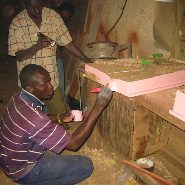
What stakeholders / implementing bodies were involved in the Approach? Specify stakeholders Describe roles of stakeholders
local land users/ local communities
SLM specialists/ agricultural advisers
NGO HELVETAS
national government (planners, decision-makers)
Involvement of local land users/ local communities in the different phases of the Approach
none
passive
external support
interactive
self-mobilization
initiation/ motivation
x
planning
x
implementation
x
monitoring/ evaluation
x
Research
x
Flow chart

Decision-making on the selection of SLM Technology

Decisions were taken by

  • land users alone (self-initiative)
  • mainly land users, supported by SLM specialists
  • all relevant actors, as part of a participatory approach
  • mainly SLM specialists, following consultation with land users
  • SLM specialists alone
  • politicians/ leaders

Decisions were made based on

  • evaluation of well-documented SLM knowledge (evidence-based decision-making)
  • research findings
  • personal experience and opinions (undocumented)

Technical support, capacity building, and knowledge management

The following activities or services have been part of the approach
Capacity building/ training
Training was provided to the following stakeholders
  • land users
  • field staff/ advisers
Form of training
  • on-the-job
  • farmer-to-farmer
  • demonstration areas
  • public meetings
  • courses
Subjects covered

Local people need to get to grips with the landscape and know how to orientate themselves in the space. The model maker must be well trained and have expertise in concepts of scale, contours and ‘scale exaggerations’

Advisory service
Advisory service was provided
  • on land users' fields
  • at permanent centres
Advisory service is quite adequate to ensure the continuation of land conservation activities; the model is facilitated by villagers themselves
Institution strengthening
Institutions have been strengthened / established
  • no
  • yes, a little
  • yes, moderately
  • yes, greatly
at the following level
  • local
  • regional
  • national
Describe institution, roles and responsibilities, members, etc.
Type of support
  • financial
  • capacity building/ training
  • equipment
Further details
Monitoring and evaluation
technical aspects were ad hoc monitored by project staff through observations socio-cultural aspects were ad hoc monitored by project staff through observations management of Approach aspects were ad hoc monitored by project staff through observations There were no changes in the Approach as a result of monitoring and evaluation There were no changes in the Technology as a result of monitoring and evaluation
Research
Research treated the following topics
  • sociology
  • economics / marketing
  • ecology
  • technology

Helvetas - Swiss Intercooperation

Financing and external material support

Annual budget in USD for the SLM component
  • < 2,000
  • 2,000-10,000
  • 10,000-100,000
  • 100,000-1,000,000
  • > 1,000,000
Precise annual budget: n.a.
Approach costs were met by the following donors: international non-government: 100.0%
The following services or incentives have been provided to land users
  • Financial/ material support provided to land users
  • Subsidies for specific inputs
  • Credit
  • Other incentives or instruments
Financial/ material support provided to land users

Impact analysis and concluding statements

Impacts of the Approach
No
Yes, little
Yes, moderately
Yes, greatly
Did the Approach help land users to implement and maintain SLM Technologies?

reduced conflicts over farming land and immediate visibility of the land pattern and spatial issues

x
Did the Approach empower socially and economically disadvantaged groups?

It is an approach that is more engaging and accessible to all – even the shyest people are able to express themselves.

x
Did other land users / projects adopt the Approach?

This tool has been used in the regions of Sikasso (Sikasso, Koutiala, Kadiolo and Yorosso) and Ségou (San and Tominian) for all the schemes delivered by HELVETAS Swiss Intercooperation. In total, more than 25 models have been made.

x
Main motivation of land users to implement SLM
Sustainability of Approach activities
Can the land users sustain what hat been implemented through the Approach (without external support)?

Conclusions and lessons learnt

Strengths: land user's view
Strengths: compiler’s or other key resource person’s view
  • The results are immediate and manifest as: reduced conflicts over farming the land in question; the immediate visibility of the land pattern and spatial issues; the involvement and motivation of local people in the design process; more inclusive decisions and the initiation of social dialogue on the scheme; an approach that is more engaging and accessible to all – even the shyest people are able to express themselves. (How to sustain/ enhance this strength: The approach must be participatory; it should not exclude any sector of society. In this respect, young people and women prove to be very good facilitators, with the model helping them to present the subject matter in a lively and engaging way.)
  • The model enables stakeholders to interpret the landscape and thus helps them in the decision-making process. It is used in consultation exercises to ensure transparency and consensual management in the implementation and evaluation of the scheme. (How to sustain/ enhance this strength: To use the model, all that is required is for it to be transported to the meeting/facilitation space, removed from its case and placed at table height or even on the ground. The facilitator then introduces the project, indicating the landmarks and cardinal directions. This serves as the basis for discussion.
    Local people need to get to grips with the landscape and know how to orientate themselves in the space. The model maker must be well trained and have expertise in concepts of scale, contours and ‘scale exaggerations’. They must have an artist’s eye. )
  • The model is tangible, durable and helps reduce social conflict. It also serves as a support for meetings with visitors. It is facilitated by villagers themselves.
Weaknesses/ disadvantages/ risks: land user's viewhow to overcome
Weaknesses/ disadvantages/ risks: compiler’s or other key resource person’s viewhow to overcome
  • Some experts from technical consultancies have the tendency to take over from the beneficiaries. Other public sector experts move things forward as quickly as possible and fail to take into account villagers’ contributions. To ensure that people are not left frustrated and, as a result, participate less in the process, it is important to give them the opportunity to express their views.
  • Modifications may be required once the model is completed. Integrating these corrections can prove difficult (engaging the same provider and carrying out alterations without diminishing the appearance of the model).

References

Compiler
  • Dieter Nill
Editors
Reviewer
  • Laura Ebneter
Date of documentation: Sept. 24, 2014
Last update: Junie 12, 2017
Resource persons
Full description in the WOCAT database
Linked SLM data
Documentation was faciliated by
Institution Project
Key references
  • Intercooperation, Délégation au Sahel (n.d.): Capitalisation d’éxperience. Eau, terre, communautés. La maquette pédagogique transportable dans l’aménagement des bas-fonds. Un outil pour les practiciens. [Delegation to the Sahel (n.d.): Capitalising on experiences. Water, land, communities. The portable instructional model for developing lowland schemes. A tool for practitioners.]: http://agriwaterpedia.info/wiki/Main_Page
  • Intercooperation, Délégation au Sahel (2009): Gestion des ressources naturelles: les acteurs s’engagent pour une gestion concertée et pacifique de leurs resources. [Delegation to the Sahel (2009): Management of natural resources – actors engage in the collaborative and peaceful management of their resources.]:
  • Good Practices in Soil and Water Conservation. A contribution to adaptation and farmers´ resilience towards climate change in the Sahel. Published by GIZ in 2012.: http://agrwaterpedia.info/wiki/Main_Page
This work is licensed under Creative Commons Attribution-NonCommercial-ShareaAlike 4.0 International