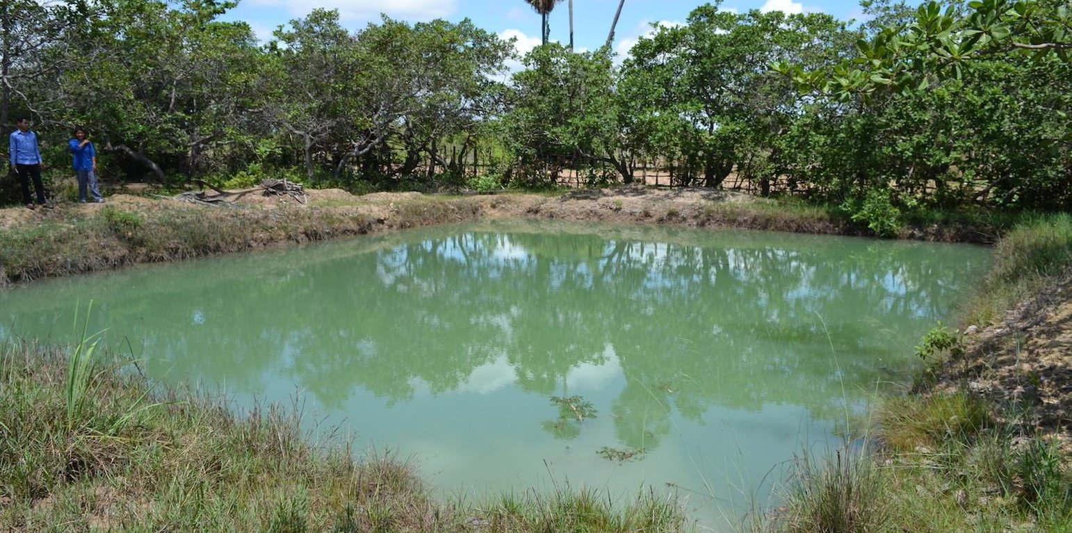
Household pond used for irrigation and fishing. (Christoph Kaufmann (Centre for Development and Environment CDE))

Use of household ponds for garden irrigation and fish production. (Cambodia)

ការប្រើប្រាស់ស្រះគ្រួសារសំរាប់ស្រោចស្រពច្បារដំណំានឹងការចឹញ្ចឹមត្រី (Khmer)

Description

Ponds are used at household level to raise fish as well as to irrigate vegetable gardens and rice seedlings

Wet-season rice is the predominantly grown crop in the area, but some land users also grow other crops (e.g. sweet potatoes, pumpkins, or peanuts). However, if droughts occur or if the rainfall patterns are erratic, the production can be harmed. Furthermore, due to the lack of water, the land users usually leave their fields bare during the dry season. This results in an increase of wind erosion and in negative impacts on the soil biota due to its exposure to the sun.

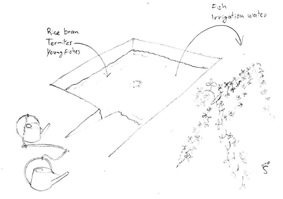
In order to tackle these challenges, ponds of 4 m depth (1 m deeper than the groundwater table during the dry season) are used at household level. By building ponds, some fields can be irrigated during the dry season, thus crops can be grown the whole year round. In this case study, sweet potatoes are the main cash crop grown on the irrigated fields during the dry season. The vines can be transplanted to the fields during the beginning of the rainy season, resulting in a better productivity of the crop. Peanuts and cucumbers are other cash crops grown on the irrigated fields.
Additionally, fish are introduced to the pond. These fish, which are caught during fishing for consumption in the flooded rice fields or nearby streams, increase the resilience of the land users: On one hand, they generate additional income and on the other hand, they allow the land users to eat fish the whole year round.

To build the ponds, the land users of this case study benefited from the road construction. The constructer needed soil, and offered to dig a pond for free if they could use the soil. They only dug 2 of the total 4 meters depth of the pond. The land users had to hire someone to dig deeper, as the groundwater level drops below 3 meters soil level during the dry season. The additional benefits from the pond, the fish are introduced as fingerlings when they are caught with the bigger fish. They are fed with termites (around 5 kg of termite nest each day) and with rice bran (1 kg every 3 days). As the pond is only 2 years old, the maintenance activities like digging out the mud did not have to be done yet.

The analysed area is flat (slope < 2%), tropic (dry and wet season), and the soils are mostly sandy or loamy. The soils contain little organic matter, the pH is sinking, the area has been deforested a long time ago and the groundwater table is rather high (1-2 m during the dry season, on the surface during wet season). and the groundwater table is rather high (3 m below soil level during the dry season, on the surface during the wet season).
Due to climate change, the rainfalls are more erratic, temperatures rise and droughts are more recurrent. Rice is the predominant crop grown in the area, since it serves as staple food (mix subsistence and commercial activities). Rice is often grown in monocultures and harvested once a year. Once the rice is harvested (dry season), some farmer release cattle to the paddy fields to eat the straw and weeds.

As an addition to rice, most land users grow vegetable and fruits in small home gardens (subsistence) and complement their income by producing handicrafts or through off farm income / remittances from family members working in other places. The increasing migration rate (the young generation leaves the villages to work in the cities, garment industry or abroad) results in a decrease of available labour force in the area which has detrimental effects on the agricultural activities. Furthermore, the civil war in the 1970s (Khmer Rouge) led to the loss of agricultural knowledge that different NGOs try to re-establish.

Location

Location: Roloer pha-er/Bantheay Preal/Tob Srauv (Village), Kampong Chhnang, Cambodia

No. of Technology sites analysed:

Geo-reference of selected sites
  • n.a.

Spread of the Technology: evenly spread over an area (approx. < 0.1 km2 (10 ha))

In a permanently protected area?:

Date of implementation: less than 10 years ago (recently)

Type of introduction
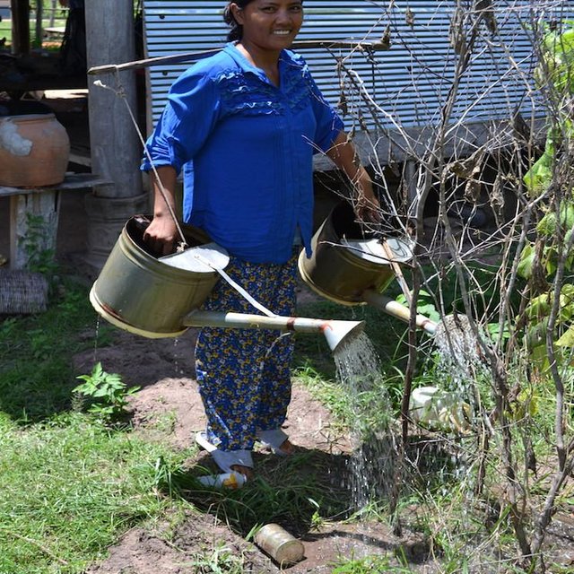
Land user irrigating with water from the household pond. (Christoph Kaufmann (Centre for Development and Environment CDE))

Classification of the Technology

Main purpose
  • improve production
  • reduce, prevent, restore land degradation
  • conserve ecosystem
  • protect a watershed/ downstream areas – in combination with other Technologies
  • preserve/ improve biodiversity
  • reduce risk of disasters
  • adapt to climate change/ extremes and its impacts
  • mitigate climate change and its impacts
  • create beneficial economic impact
  • create beneficial social impact
Land use

  • Cropland
    • Annual cropping
    Number of growing seasons per year: 1
  • Waterways, waterbodies, wetlands - Ponds, dams

Water supply
  • rainfed
  • mixed rainfed-irrigated
  • full irrigation

Purpose related to land degradation
  • prevent land degradation
  • reduce land degradation
  • restore/ rehabilitate severely degraded land
  • adapt to land degradation
  • not applicable
Degradation addressed
  • biological degradation - Bq: quantity/ biomass decline
  • water degradation - Ha: aridification
SLM group
  • irrigation management (incl. water supply, drainage)
  • surface water management (spring, river, lakes, sea)
  • beekeeping, aquaculture, poultry, rabbit farming, silkworm farming, etc.
SLM measures
  • structural measures - S4: Level ditches, pits

Technical drawing

Technical specifications
Pond used for irrigation as well as for fish production. In this case two watering cans are used, with a stick between them to transfer the weight to the shoulders.

Kampong Chhnang
Date: 2014

Technical knowledge required for field staff / advisors: low (No field staff was involved.)
Technical knowledge required for land users: low
Main technical functions: water harvesting / increase water supply

Dam/ pan/ pond
Depth of ditches/pits/dams (m): 4
Width of ditches/pits/dams (m): 12
Length of ditches/pits/dams (m): 18
Specification of dams/ pans/ ponds: Capacity 800m3
Catchment area: ground waterm2
Author: Stefan Graf, Switzerland

Establishment and maintenance: activities, inputs and costs

Calculation of inputs and costs
  • Costs are calculated:
  • Currency used for cost calculation: n.a.
  • Exchange rate (to USD): 1 USD = n.a
  • Average wage cost of hired labour per day: 5.00
Most important factors affecting the costs
The most expensive factor is the availability of an excavator to dig the pond.
Establishment activities
  1. Dig the first 2 m (Timing/ frequency: Dry season)
  2. Dig the last 2 m (Timing/ frequency: Dry season)
Establishment inputs and costs
Specify input Unit Quantity Costs per Unit (n.a.) Total costs per input (n.a.) % of costs borne by land users
Equipment
machine use 1.0 100.0 100.0 50.0
Total costs for establishment of the Technology 100.0
Total costs for establishment of the Technology in USD 100.0
Maintenance activities
  1. Catch and select fingerlings in the rice fields and canals. (Timing/ frequency: Every year during wet season)
  2. Select fingerlings from catch in local streams to add in pond. (Timing/ frequency: Every year during dry season.)
  3. Dig out the pond. Not yet done, as the pond is still new. (Timing/ frequency: None)
  4. Feed the fish with termites and rice bran. (Timing/ frequency: Regularly.)
  5. Fertilize the pond (Timing/ frequency: Yearly in the beginning of the wet season)
Maintenance inputs and costs
Specify input Unit Quantity Costs per Unit (n.a.) Total costs per input (n.a.) % of costs borne by land users
Labour
labour 1.0 134.5 134.5 100.0
Total costs for maintenance of the Technology 134.5
Total costs for maintenance of the Technology in USD 134.5

Natural environment

Average annual rainfall
  • < 250 mm
  • 251-500 mm
  • 501-750 mm
  • 751-1,000 mm
  • 1,001-1,500 mm
  • 1,501-2,000 mm
  • 2,001-3,000 mm
  • 3,001-4,000 mm
  • > 4,000 mm
Agro-climatic zone
  • humid
  • sub-humid
  • semi-arid
  • arid
Specifications on climate
1486.45 mm (2013) in Kampong Chhnang
Thermal climate class: tropics. 27-35°C
Slope
  • flat (0-2%)
  • gentle (3-5%)
  • moderate (6-10%)
  • rolling (11-15%)
  • hilly (16-30%)
  • steep (31-60%)
  • very steep (>60%)
Landforms
  • plateau/plains
  • ridges
  • mountain slopes
  • hill slopes
  • footslopes
  • valley floors
Altitude
  • 0-100 m a.s.l.
  • 101-500 m a.s.l.
  • 501-1,000 m a.s.l.
  • 1,001-1,500 m a.s.l.
  • 1,501-2,000 m a.s.l.
  • 2,001-2,500 m a.s.l.
  • 2,501-3,000 m a.s.l.
  • 3,001-4,000 m a.s.l.
  • > 4,000 m a.s.l.
Technology is applied in
  • convex situations
  • concave situations
  • not relevant
Soil depth
  • very shallow (0-20 cm)
  • shallow (21-50 cm)
  • moderately deep (51-80 cm)
  • deep (81-120 cm)
  • very deep (> 120 cm)
Soil texture (topsoil)
  • coarse/ light (sandy)
  • medium (loamy, silty)
  • fine/ heavy (clay)
Soil texture (> 20 cm below surface)
  • coarse/ light (sandy)
  • medium (loamy, silty)
  • fine/ heavy (clay)
Topsoil organic matter content
  • high (>3%)
  • medium (1-3%)
  • low (<1%)
Groundwater table
  • on surface
  • < 5 m
  • 5-50 m
  • > 50 m
Availability of surface water
  • excess
  • good
  • medium
  • poor/ none
Water quality (untreated)
  • good drinking water
  • poor drinking water (treatment required)
  • for agricultural use only (irrigation)
  • unusable
Water quality refers to:
Is salinity a problem?
  • Ja
  • Nee

Occurrence of flooding
  • Ja
  • Nee
Species diversity
  • high
  • medium
  • low
Habitat diversity
  • high
  • medium
  • low

Characteristics of land users applying the Technology

Market orientation
  • subsistence (self-supply)
  • mixed (subsistence/ commercial)
  • commercial/ market
Off-farm income
  • less than 10% of all income
  • 10-50% of all income
  • > 50% of all income
Relative level of wealth
  • very poor
  • poor
  • average
  • rich
  • very rich
Level of mechanization
  • manual work
  • animal traction
  • mechanized/ motorized
Sedentary or nomadic
  • Sedentary
  • Semi-nomadic
  • Nomadic
Individuals or groups
  • individual/ household
  • groups/ community
  • cooperative
  • employee (company, government)
Gender
  • women
  • men
Age
  • children
  • youth
  • middle-aged
  • elderly
Area used per household
  • < 0.5 ha
  • 0.5-1 ha
  • 1-2 ha
  • 2-5 ha
  • 5-15 ha
  • 15-50 ha
  • 50-100 ha
  • 100-500 ha
  • 500-1,000 ha
  • 1,000-10,000 ha
  • > 10,000 ha
Scale
  • small-scale
  • medium-scale
  • large-scale
Land ownership
  • state
  • company
  • communal/ village
  • group
  • individual, not titled
  • individual, titled
Land use rights
  • open access (unorganized)
  • communal (organized)
  • leased
  • individual
Water use rights
  • open access (unorganized)
  • communal (organized)
  • leased
  • individual
Access to services and infrastructure
health

poor
good
education

poor
good
technical assistance

poor
good
employment (e.g. off-farm)

poor
good
markets

poor
good
energy

poor
good
roads and transport

poor
good
drinking water and sanitation

poor
good
financial services

poor
good

Impacts

Socio-economic impacts
Crop production
decreased
increased

animal production
decreased
increased


Fish

risk of production failure
increased
decreased

product diversity
decreased
increased

production area (new land under cultivation/ use)
decreased
increased

farm income
decreased
increased

diversity of income sources
decreased
increased

Socio-cultural impacts
food security/ self-sufficiency
reduced
improved

contribution to human well-being
decreased
increased


Ponds allow the land user to grow crops the whole year round. Furthermore, there are fish in the pond which provide a reliable source of food.

Ecological impacts
water quantity
decreased
increased

soil moisture
decreased
increased

Off-site impacts

Cost-benefit analysis

Benefits compared with establishment costs
Short-term returns
very negative
very positive

Long-term returns
very negative
very positive

Benefits compared with maintenance costs
Short-term returns
very negative
very positive

Long-term returns
very negative
very positive

Climate change

Gradual climate change
annual temperature increase

not well at all
very well
Climate-related extremes (disasters)
local rainstorm

not well at all
very well
local windstorm

not well at all
very well
drought

not well at all
very well
general (river) flood

not well at all
very well
Other climate-related consequences
reduced growing period

not well at all
very well

Adoption and adaptation

Percentage of land users in the area who have adopted the Technology
  • single cases/ experimental
  • 1-10%
  • 11-50%
  • > 50%
Of all those who have adopted the Technology, how many have done so without receiving material incentives?
  • 0-10%
  • 11-50%
  • 51-90%
  • 91-100%
Has the Technology been modified recently to adapt to changing conditions?
  • Ja
  • Nee
To which changing conditions?
  • climatic change/ extremes
  • changing markets
  • labour availability (e.g. due to migration)

Conclusions and lessons learnt

Strengths: land user's view
  • Water available in the dry season for cash crops. The rice fields can be used in the dry season instead of being left bare.
  • The rice seedlings can be irrigated during the early wet season in case of drought or erratic rainfall.
  • Diversification of diet and income: fish is available the whole year round.
Strengths: compiler’s or other key resource person’s view
  • As parts of the rice fields are irrigated and planted during the dry season, there is less wind erosion and the soil is improving.
  • The fish feed (rice bran and termites) consists of local resources.
Weaknesses/ disadvantages/ risks: land user's viewhow to overcome
  • If flooded the fish can go away. Nets need to be put around the pond in the wet season. This farmer already does this.
  • Fingerlings are difficult to find. Find a fish breeder, or breed fish by themselves. Creating niches in the ponds for the offspring, where the bigger fish do not eat it, could do the breeding.
Weaknesses/ disadvantages/ risks: compiler’s or other key resource person’s viewhow to overcome
  • Fingerlings of different sizes and species are put into the pond. The bigger eat the smaller. Fence off areas for bigger fish, and move the big fish there so they cannot catch the smaller. Or build structures where the smaller fish can hide.

References

Compiler
  • Christoph Kaufmann
Editors
Reviewer
  • Deborah Niggli
  • Alexandra Gavilano
Date of documentation: Okt. 16, 2014
Last update: Maart 11, 2019
Resource persons
Full description in the WOCAT database
Linked SLM data
Documentation was faciliated by
Institution Project
Key references
  • Konhel Pith, Local Agricultural Research and Extension Centre LAREC in Kampong Chhnang; khonhel@gmail.com:
This work is licensed under Creative Commons Attribution-NonCommercial-ShareaAlike 4.0 International