Longan, Plum interplanting
(China)
Development of Southward Fruit Trees
Description
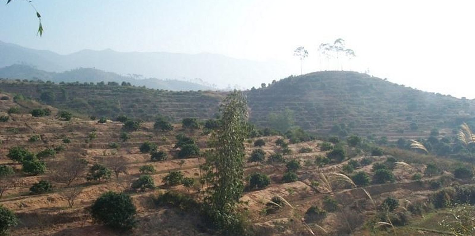
Interplanting plum, peach in the Longan orchard to conserve soil and water and improve soil fertility.
The technology is to interplant fruit trees in orchard so as to prevent water loss and soil erosion. To implement the project, local government gave financial support and SWC specialists gave technologically guide to local land users. The slope land in the hilly and mountain areas were constructed into terraces and plant trees in order to improve surface vegetation cover rate and reduce water and soil loss; the harvesting surplus rainfall in the raining season and irrigate the fruit trees in dry seasons.
Location
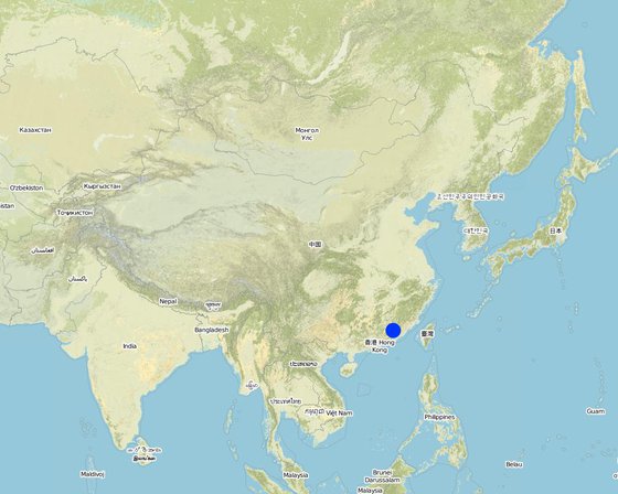
Location: Fujian, China
No. of Technology sites analysed:
Geo-reference of selected sites
Spread of the Technology: evenly spread over an area (approx. 10-100 km2)
In a permanently protected area?:
Date of implementation: more than 50 years ago (traditional)
Type of introduction
-
through land users' innovation
-
as part of a traditional system (> 50 years)
-
during experiments/ research
-
through projects/ external interventions
Classification of the Technology
Main purpose
-
improve production
-
reduce, prevent, restore land degradation
-
conserve ecosystem
-
protect a watershed/ downstream areas – in combination with other Technologies
-
preserve/ improve biodiversity
-
reduce risk of disasters
-
adapt to climate change/ extremes and its impacts
-
mitigate climate change and its impacts
-
create beneficial economic impact
-
create beneficial social impact
Land use
Land use mixed within the same land unit: Ja - Agroforestry
-
Cropland
- Annual cropping
- Perennial (non-woody) cropping
- Tree and shrub cropping: stone fruits (peach, apricot, cherry, plum, etc)
Number of growing seasons per year: 2
Is intercropping practiced? Ja
-
Forest/ woodlandsProducts and services: Timber, Fuelwood, Fruits and nuts
Water supply
-
rainfed
-
mixed rainfed-irrigated
-
full irrigation
Purpose related to land degradation
-
prevent land degradation
-
reduce land degradation
-
restore/ rehabilitate severely degraded land
-
adapt to land degradation
-
not applicable
Degradation addressed
-
soil erosion by water - Wt: loss of topsoil/ surface erosion, Wg: gully erosion/ gullying
SLM measures
-
vegetative measures - V1: Tree and shrub cover
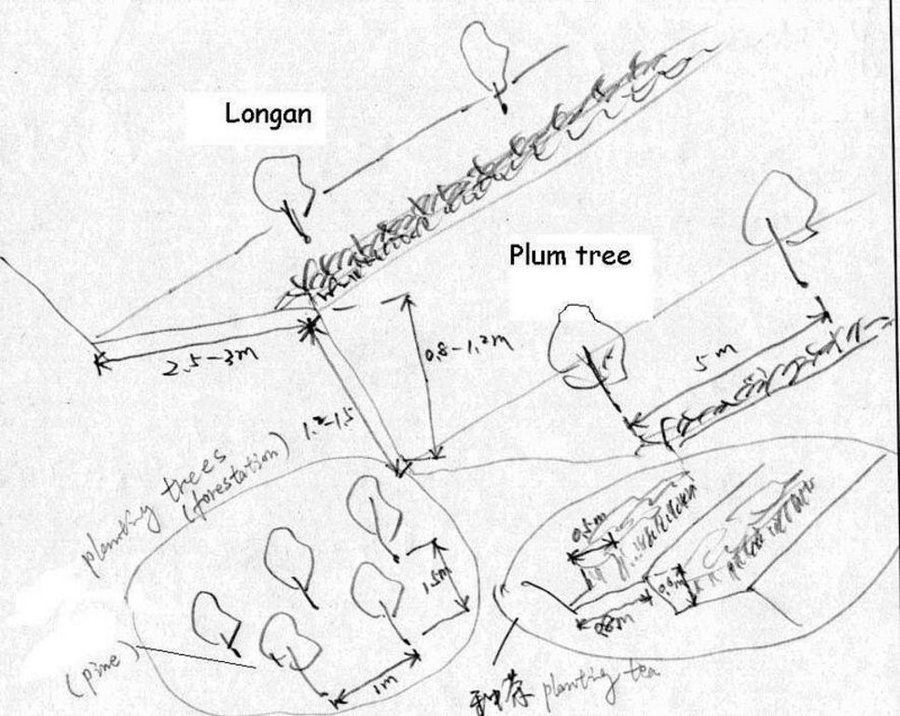
Technical drawing
Technical specifications
Technical drawing of interplanting in orchard.
Location: Zhaoan county. Fujian
Date: 1997
Technical knowledge required for field staff / advisors: moderate
Technical knowledge required for land users: low
Main technical functions: control of dispersed runoff: impede / retard
Secondary technical functions: reduction of slope angle, improvement of ground cover, wind-break
Mixed cropping / intercropping
Material/ species: Plum trees
Quantity/ density: 238
Remarks: increasing ground cover
Contour ridging
Remarks: reasonable layout
Trees/ shrubs species: jequirity tree
Perennial crops species: Plum, peach lichi trees
Slope (which determines the spacing indicated above): 30.00%
If the original slope has changed as a result of the Technology, the slope today is (see figure below): 15.00%
Gradient along the rows / strips: 60.00%
Construction material (earth): cheaper, local materials, good effect
Slope (which determines the spacing indicated above): 28.00%
If the original slope has changed as a result of the Technology, the slope today is: 13.00%
Lateral gradient along the structure: 26.00%
For water harvesting: the ratio between the area where the harvested water is applied and the total area from which water is collected is: 1:2.00
Vegetation is used for stabilisation of structures.
Change of land use practices / intensity level: Forbidding disafforest in mountain areas for 3 years.
Author: LIU Zhangsheng, Zhaoan, China
Establishment and maintenance: activities, inputs and costs
Calculation of inputs and costs
- Costs are calculated:
- Currency used for cost calculation: USD
- Exchange rate (to USD): 1 USD = 8.3
- Average wage cost of hired labour per day: 2.40
Most important factors affecting the costs
Main factor influencing the SWC cost is steeper slope. Since the slope steeper is, much more cost needed to level off terrace. In some places, the earth needs to be moved from one place to another which will spend a lot of labor forces.
Establishment activities
-
plant trees (Timing/ frequency: spring)
-
Level off land (Timing/ frequency: winter)
-
weed (Timing/ frequency: winter)
-
digging ditch (Timing/ frequency: spring)
-
Level off land (Timing/ frequency: Autumn)
-
costruct bank of field (Timing/ frequency: winter)
-
Closure and forbidding disafforest (Timing/ frequency: 3 years)
Maintenance activities
-
digging ditch(interplant) (Timing/ frequency: winter / Annually)
-
irrigate (Timing/ frequency: spring / Each cropping season)
-
fertilization (Timing/ frequency: Mar.Jun.Sep. /Annual)
-
spew pesticide (Timing/ frequency: Apl.Jul. /Annual)
-
reinforce banks of level terrace (Timing/ frequency: autumn/Annual)
-
complementing seedling (Timing/ frequency: spring / 1)
-
Fertilizing (Timing/ frequency: Mar. Jun. / 2)
Natural environment
Average annual rainfall
-
< 250 mm
-
251-500 mm
-
501-750 mm
-
751-1,000 mm
-
1,001-1,500 mm
-
1,501-2,000 mm
-
2,001-3,000 mm
-
3,001-4,000 mm
-
> 4,000 mm
Agro-climatic zone
-
humid
-
sub-humid
-
semi-arid
-
arid
Specifications on climate
n.a.
Slope
-
flat (0-2%)
-
gentle (3-5%)
-
moderate (6-10%)
-
rolling (11-15%)
-
hilly (16-30%)
-
steep (31-60%)
-
very steep (>60%)
Landforms
-
plateau/plains
-
ridges
-
mountain slopes
-
hill slopes
-
footslopes
-
valley floors
Altitude
-
0-100 m a.s.l.
-
101-500 m a.s.l.
-
501-1,000 m a.s.l.
-
1,001-1,500 m a.s.l.
-
1,501-2,000 m a.s.l.
-
2,001-2,500 m a.s.l.
-
2,501-3,000 m a.s.l.
-
3,001-4,000 m a.s.l.
-
> 4,000 m a.s.l.
Technology is applied in
-
convex situations
-
concave situations
-
not relevant
Soil depth
-
very shallow (0-20 cm)
-
shallow (21-50 cm)
-
moderately deep (51-80 cm)
-
deep (81-120 cm)
-
very deep (> 120 cm)
Soil texture (topsoil)
-
coarse/ light (sandy)
-
medium (loamy, silty)
-
fine/ heavy (clay)
Soil texture (> 20 cm below surface)
-
coarse/ light (sandy)
-
medium (loamy, silty)
-
fine/ heavy (clay)
Topsoil organic matter content
-
high (>3%)
-
medium (1-3%)
-
low (<1%)
Groundwater table
-
on surface
-
< 5 m
-
5-50 m
-
> 50 m
Availability of surface water
-
excess
-
good
-
medium
-
poor/ none
Water quality (untreated)
-
good drinking water
-
poor drinking water (treatment required)
-
for agricultural use only (irrigation)
-
unusable
Is salinity a problem?
Occurrence of flooding
Characteristics of land users applying the Technology
Market orientation
-
subsistence (self-supply)
-
mixed (subsistence/ commercial)
-
commercial/ market
Off-farm income
-
less than 10% of all income
-
10-50% of all income
-
> 50% of all income
Relative level of wealth
-
very poor
-
poor
-
average
-
rich
-
very rich
Level of mechanization
-
manual work
-
animal traction
-
mechanized/ motorized
Sedentary or nomadic
-
Sedentary
-
Semi-nomadic
-
Nomadic
Individuals or groups
-
individual/ household
-
groups/ community
-
cooperative
-
employee (company, government)
Age
-
children
-
youth
-
middle-aged
-
elderly
Area used per household
-
< 0.5 ha
-
0.5-1 ha
-
1-2 ha
-
2-5 ha
-
5-15 ha
-
15-50 ha
-
50-100 ha
-
100-500 ha
-
500-1,000 ha
-
1,000-10,000 ha
-
> 10,000 ha
Scale
-
small-scale
-
medium-scale
-
large-scale
Land ownership
-
state
-
company
-
communal/ village
-
group
-
individual, not titled
-
individual, titled
Land use rights
-
open access (unorganized)
-
communal (organized)
-
leased
-
individual
Water use rights
-
open access (unorganized)
-
communal (organized)
-
leased
-
individual
Access to services and infrastructure
Cost-benefit analysis
Benefits compared with establishment costs
Short-term returns
very negative
very positive
Long-term returns
very negative
very positive
Benefits compared with maintenance costs
Short-term returns
very negative
very positive
Long-term returns
very negative
very positive
Adoption and adaptation
Percentage of land users in the area who have adopted the Technology
-
single cases/ experimental
-
1-10%
-
11-50%
-
> 50%
Of all those who have adopted the Technology, how many have done so without receiving material incentives?
-
0-10%
-
11-50%
-
51-90%
-
91-100%
Number of households and/ or area covered
1253 households
Has the Technology been modified recently to adapt to changing conditions?
To which changing conditions?
-
climatic change/ extremes
-
changing markets
-
labour availability (e.g. due to migration)
Conclusions and lessons learnt
Strengths: land user's view
Strengths: compiler’s or other key resource person’s view
Weaknesses/ disadvantages/ risks: land user's viewhow to overcome
Weaknesses/ disadvantages/ risks: compiler’s or other key resource person’s viewhow to overcome
References
Reviewer
-
David Streiff
-
Alexandra Gavilano
Date of documentation: Nov. 29, 2010
Last update: Maart 14, 2019
Resource persons
-
zhangsheng LIU - SLM specialist
Full description in the WOCAT database
Documentation was faciliated by
Institution
- Water & Soil Conservation Office of Zhaoan County (Water & Soil Conservation Office of Zhaoan County) - China
Project