creation of meliorative plantings for struggle with erosion
(Kazakhstan)
no
Description
Technology of creation of meliorative plantings for struggle against wind and water erosion
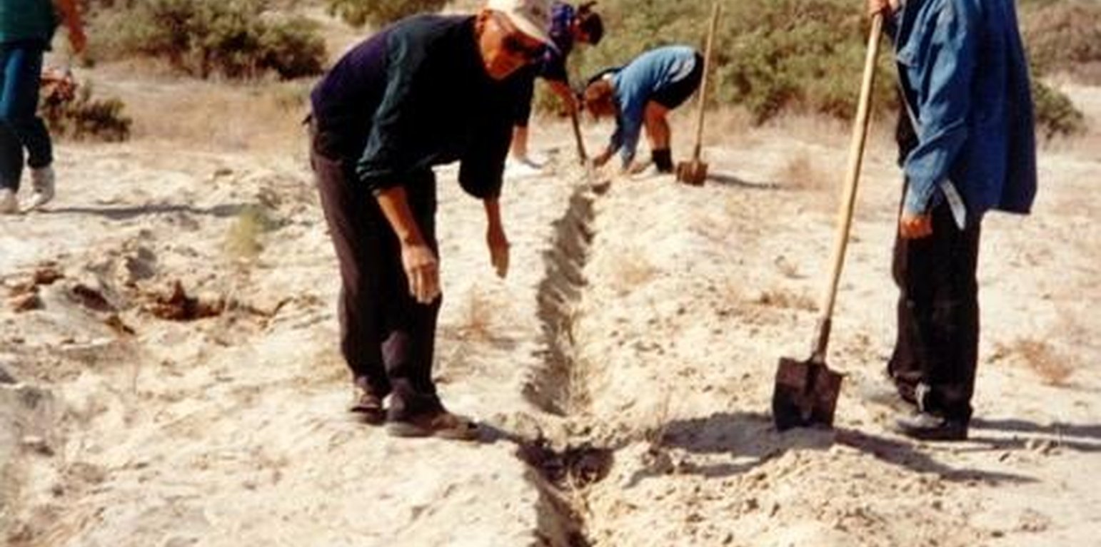
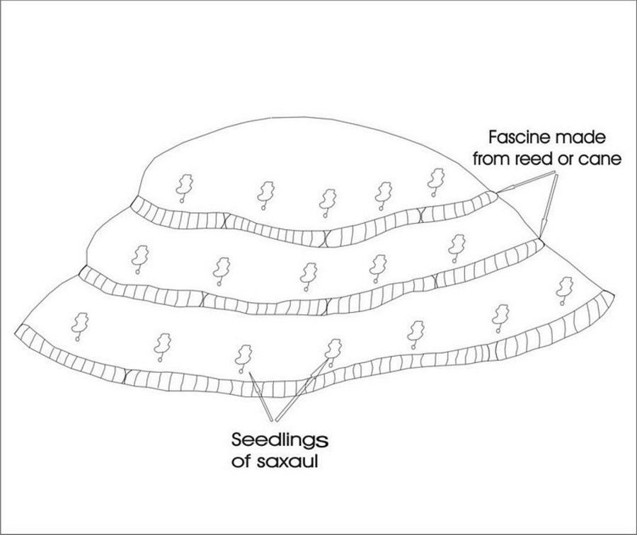
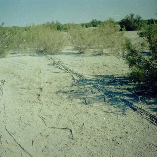
In Syrdarya river’s delta on alluvial drought sandy and loam sand soils processes of wind and water erosion become more active with a view of protection of the soils it is applied covering fascine made from a local cane or reed. Fascines thickness 12-15 cm settle down on a surface by lines in a 2-3 m. On distance of 20 centimeters it is carried out planting of a saxaul seedlings
-Planting of the saplings was done in holes and uninterrupted furrows, which were formed by hands.
-Depth of holes and furrows is 20-25 cm.
-Distance between holes was 1.5-2 m.
-Furrows were perpendicular to the prevailing winds (west-east) and placing mould in several optio0ns: 1- moulds on both sides; 2- the same from the southern side of a furrow; 3- the same from the northern side. Furrows alternated with holes rows.
-Length of rows variants in repetition was 100 m.
-Saplings were filled up by hands in rows in 1-2 meters, distance between rows was 2-2.5 meters.
Prevention of water and wind erosion on sandy and loamy sand soils of the Syrdarya delta.
Many farmers use the given technology for prevention of wind and water erosion on the lands.
The technology is applied on the area of 1.5 sq.km. Expenses per 1 ha make 99.2 $ USA or 14880 tenge.
Irrevocable water consumption in agricultural land use in the Syrdarya delta, development of the areas of irrigation, livestock grazing led to the contradiction between the agricultural industry and the ecological state of the region. It caused more intense processes of desertification, among them are soil salification and increase in the groundwater mineralization: degradation of vegetation cover; erosion and soil deflation; wind-blowing of the salts from dried bed of the Aral Sea; sand advance on the arable land, etc. At present about of 60% of irrigated areas within the Syrdarya delta are strongly salificated.
Location
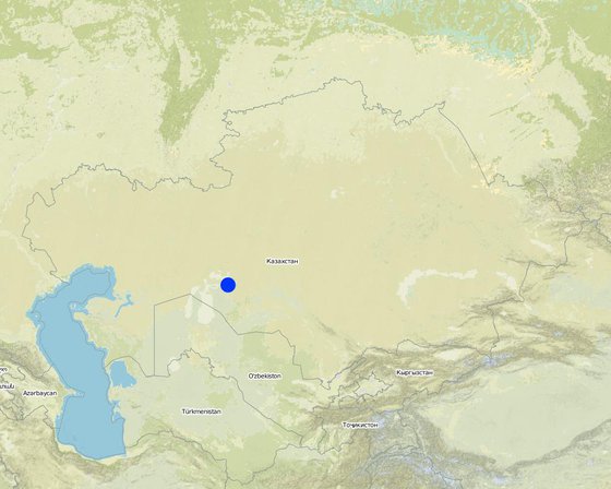
Location: Kazalinsk, Kyzylorda oblast, Kazakhstan
No. of Technology sites analysed:
Geo-reference of selected sites
Spread of the Technology: evenly spread over an area (3.5 km²)
In a permanently protected area?:
Date of implementation: less than 10 years ago (recently)
Type of introduction
-
through land users' innovation
-
as part of a traditional system (> 50 years)
-
during experiments/ research
-
through projects/ external interventions
Ameliorative plantings
Classification of the Technology
Main purpose
-
improve production
-
reduce, prevent, restore land degradation
-
conserve ecosystem
-
protect a watershed/ downstream areas – in combination with other Technologies
-
preserve/ improve biodiversity
-
reduce risk of disasters
-
adapt to climate change/ extremes and its impacts
-
mitigate climate change and its impacts
-
create beneficial economic impact
-
create beneficial social impact
Land use
Land use mixed within the same land unit: Ja - Agro-silvopastoralism
-
Cropland
- Annual cropping: cereals - maize, cereals - rice (upland)
- Tree and shrub cropping: fodder trees (Calliandra, Leucaena leucocephala, Prosopis, etc.), Saxaul (cf. Haloxylon ammodendron)
Number of growing seasons per year: 2
-
Forest/ woodlandsProducts and services: Fuelwood
Water supply
-
rainfed
-
mixed rainfed-irrigated
-
full irrigation
Purpose related to land degradation
-
prevent land degradation
-
reduce land degradation
-
restore/ rehabilitate severely degraded land
-
adapt to land degradation
-
not applicable
Degradation addressed
-
soil erosion by water - Wt: loss of topsoil/ surface erosion
-
soil erosion by wind - Et: loss of topsoil
SLM group
-
windbreak/ shelterbelt
-
improved ground/ vegetation cover
SLM measures
-
vegetative measures - V1: Tree and shrub cover
-
structural measures - S3: Graded ditches, channels, waterways
Technical drawing
Technical specifications
Ameliorative plantings
Technical knowledge required for field staff / advisors: low
Technical knowledge required for land users: low
Main technical functions: reduction in wind speed
Aligned: -against wind
Vegetative material: T : trees / shrubs, G : grass
Number of plants per (ha): 3000
Vertical interval between rows / strips / blocks (m): 2
Spacing between rows / strips / blocks (m): 2
Vertical interval within rows / strips / blocks (m): 1,5
Width within rows / strips / blocks (m): 0,2
Trees/ shrubs species: saxaul seedling
Grass species: prostrate summer cypress, winterfat, corn
Dam/ pan/ pond
Vertical interval between structures (m): 2
Spacing between structures (m): 2
Height of bunds/banks/others (m): 0,05
Width of bunds/banks/others (m): 0,5
Length of bunds/banks/others (m): 100
Construction material (other): Reed fascines
Establishment and maintenance: activities, inputs and costs
Calculation of inputs and costs
- Costs are calculated:
- Currency used for cost calculation: USD
- Exchange rate (to USD): 1 USD = n.a
- Average wage cost of hired labour per day: 5.00
Most important factors affecting the costs
Manufacturing of reed fascines, purchase and planting saxaul's seedlinfs
Establishment activities
-
Stacking of fascines (Timing/ frequency: summer)
-
Slips' planting (Timing/ frequency: autumn, spring)
-
Laying fascines (Timing/ frequency: summer)
-
Slips' planting (Timing/ frequency: spring, autumn)
Establishment inputs and costs
| Specify input |
Unit |
Quantity |
Costs per Unit (USD) |
Total costs per input (USD) |
% of costs borne by land users |
|
Labour
|
| Labour |
persons/day/ha |
3.0 |
5.0 |
15.0 |
100.0 |
|
Equipment
|
| Machine use |
ha |
1.0 |
20.0 |
20.0 |
100.0 |
| Tools |
ha |
1.0 |
10.0 |
10.0 |
100.0 |
|
Plant material
|
| Seedlings |
ha |
1.0 |
165.0 |
165.0 |
100.0 |
|
Construction material
|
| Other |
ha |
1.0 |
10.0 |
10.0 |
100.0 |
| Total costs for establishment of the Technology |
220.0 |
|
| Total costs for establishment of the Technology in USD |
220.0 |
|
Maintenance activities
-
Additional planting (Timing/ frequency: spring /1)
-
Supplementary slips' planting (Timing/ frequency: spring, autumn/1)
-
Supplementary fascines' setting (Timing/ frequency: spring, autumn/1)
Natural environment
Average annual rainfall
-
< 250 mm
-
251-500 mm
-
501-750 mm
-
751-1,000 mm
-
1,001-1,500 mm
-
1,501-2,000 mm
-
2,001-3,000 mm
-
3,001-4,000 mm
-
> 4,000 mm
Agro-climatic zone
-
humid
-
sub-humid
-
semi-arid
-
arid
Specifications on climate
Average annual rainfall in mm: 124.0
Deserted
Slope
-
flat (0-2%)
-
gentle (3-5%)
-
moderate (6-10%)
-
rolling (11-15%)
-
hilly (16-30%)
-
steep (31-60%)
-
very steep (>60%)
Landforms
-
plateau/plains
-
ridges
-
mountain slopes
-
hill slopes
-
footslopes
-
valley floors
Altitude
-
0-100 m a.s.l.
-
101-500 m a.s.l.
-
501-1,000 m a.s.l.
-
1,001-1,500 m a.s.l.
-
1,501-2,000 m a.s.l.
-
2,001-2,500 m a.s.l.
-
2,501-3,000 m a.s.l.
-
3,001-4,000 m a.s.l.
-
> 4,000 m a.s.l.
Technology is applied in
-
convex situations
-
concave situations
-
not relevant
Soil depth
-
very shallow (0-20 cm)
-
shallow (21-50 cm)
-
moderately deep (51-80 cm)
-
deep (81-120 cm)
-
very deep (> 120 cm)
Soil texture (topsoil)
-
coarse/ light (sandy)
-
medium (loamy, silty)
-
fine/ heavy (clay)
Soil texture (> 20 cm below surface)
-
coarse/ light (sandy)
-
medium (loamy, silty)
-
fine/ heavy (clay)
Topsoil organic matter content
-
high (>3%)
-
medium (1-3%)
-
low (<1%)
Groundwater table
-
on surface
-
< 5 m
-
5-50 m
-
> 50 m
Availability of surface water
-
excess
-
good
-
medium
-
poor/ none
Water quality (untreated)
-
good drinking water
-
poor drinking water (treatment required)
-
for agricultural use only (irrigation)
-
unusable
Is salinity a problem?
Occurrence of flooding
Characteristics of land users applying the Technology
Market orientation
-
subsistence (self-supply)
-
mixed (subsistence/ commercial)
-
commercial/ market
Off-farm income
-
less than 10% of all income
-
10-50% of all income
-
> 50% of all income
Relative level of wealth
-
very poor
-
poor
-
average
-
rich
-
very rich
Level of mechanization
-
manual work
-
animal traction
-
mechanized/ motorized
Sedentary or nomadic
-
Sedentary
-
Semi-nomadic
-
Nomadic
Individuals or groups
-
individual/ household
-
groups/ community
-
cooperative
-
employee (company, government)
Age
-
children
-
youth
-
middle-aged
-
elderly
Area used per household
-
< 0.5 ha
-
0.5-1 ha
-
1-2 ha
-
2-5 ha
-
5-15 ha
-
15-50 ha
-
50-100 ha
-
100-500 ha
-
500-1,000 ha
-
1,000-10,000 ha
-
> 10,000 ha
Scale
-
small-scale
-
medium-scale
-
large-scale
Land ownership
-
state
-
company
-
communal/ village
-
group
-
individual, not titled
-
individual, titled
Land use rights
-
open access (unorganized)
-
communal (organized)
-
leased
-
individual
Water use rights
-
open access (unorganized)
-
communal (organized)
-
leased
-
individual
Access to services and infrastructure
Impacts
Socio-economic impacts
Crop production
The projective covering increases
farm income
Increase in effeciency of livestock
Socio-cultural impacts
community institutions
Increase of farmer's living level
Off-site impacts
wind transported sediments
Erosion of surface of the ground are stopping
Cost-benefit analysis
Benefits compared with establishment costs
Long-term returns
very negative
very positive
Benefits compared with maintenance costs
Long-term returns
very negative
very positive
Adoption and adaptation
Percentage of land users in the area who have adopted the Technology
-
single cases/ experimental
-
1-10%
-
11-50%
-
> 50%
Of all those who have adopted the Technology, how many have done so without receiving material incentives?
-
0-10%
-
11-50%
-
51-90%
-
91-100%
Number of households and/ or area covered
15 households covering 20 percent of stated area
Has the Technology been modified recently to adapt to changing conditions?
To which changing conditions?
-
climatic change/ extremes
-
changing markets
-
labour availability (e.g. due to migration)
Conclusions and lessons learnt
Strengths: land user's view
-
Decrease in the areas of wind and water erosion
How can they be sustained / enhanced? For a long time enough depending on life cycle of wood-bushes vegetation
-
Improvement of microclimatic conditions of settlements
How can they be sustained / enhanced? During all time of existence of the green zone created with the help of SWC
Strengths: compiler’s or other key resource person’s view
-
Stabilization of mobile sand
How can they be sustained / enhanced? At rational use of technology the created ecosystem can be supported for some life cycles with help of the main wood breed
-
Elimination of drifts of settlements by sand
-
Returning the grounds in rotation of the pasture
-
Creation of additional workplaces
Weaknesses/ disadvantages/ risks: land user's viewhow to overcome
-
Shortage of seedlings for the big areas
Creation of artificial nurseries
Weaknesses/ disadvantages/ risks: compiler’s or other key resource person’s viewhow to overcome
-
Almost hundred percentage use of manual skills
Development of new machines and mechanisms
-
Probably low survival of seedlings and absence of shoots because the weather conditions are not good enough
The organization of post planting watering
References
Reviewer
-
David Streiff
-
Alexandra Gavilano
Date of documentation: Junie 5, 2011
Last update: Sept. 4, 2019
Resource persons
-
Vladimir Kaverin - SLM specialist
-
Abdul-Bari Salimov - SLM specialist
Full description in the WOCAT database
Documentation was faciliated by
Institution
- SPC of Forest Facility (SPC of Forest Facility) - Kazakhstan
Project
Key references
-
"To develop scientific bases of forest amelioration of the grounds of a naked bottom of Aral sea, classification of types of growth conditions" Kaverin V.S.. 2000y.: SPC for forest facility58 Kirov str. Shuchinsk cityAkmola regionThe Republic of Kazakhstan