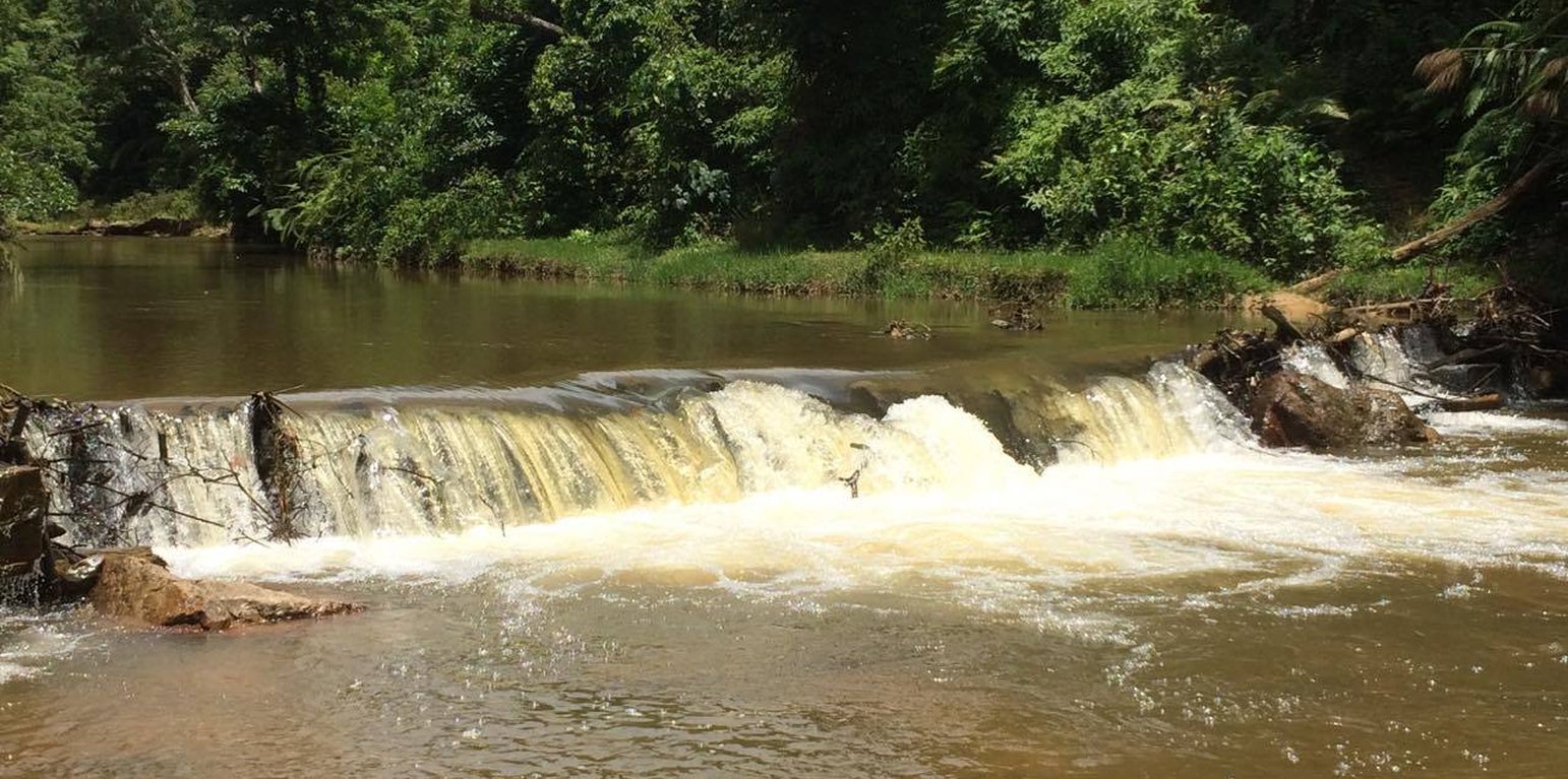
Local dyke (Khampheng Bounyavong)

Local indigenous dyke for water harvesting (Lao People's Democratic Republic)

Description

A Local Indigenous Weir to Harness Water

Local villagers initiated the construction and use of communal weir with locally available materials such as wood and stones to create structure and stabilize the weir. Previously, the local people had constructed several irrigation weirs on a particular stream with each one being adjacent to an individual farm. However this arrangement created water use conflicts, particularly during dry season. Therefore people decided to group together in 2003 in order to build a communal weir and vowed to maintain it on an annual basis. This was a significant commitment as often it is difficult to find the necessary construction materials for the weir’s upkeep.
The main features and components of its framework should be prepared in the following manner: Firstly prior to beginning the weir’s construction one should gather rattan with length of 1-1.5 meters to tie the logs with each posts, as well as post with a diameter approximately 10 cm that should be cut to a length of 1.5 meters. The posts should then be sharpened at the end so that they can ideally be driven 50 cm into the ground, but this will depend on the conditions at the weir site. There should be a distance of 50 cm between each of the posts and these should be installed in two parallel rows with a space of 1 meter between the rows each rows width 1 meters and height 1 meter from the ground that cross the stream about 25 meters long.
Once this has been completed logs with diameter about 20 cm and a length of 4-5 meters should be slotted behind the rows posts and lay the another logs on the previous post until reach to the top of the post as the first layer. The second layer behind the logs should consist of small stones, soil, as well as branches and sticks. This procedure should be completed until the wall of horizontal logs has reached the height 1 meter of the top of the posts. Afterwards large stones should be placed as the top layer of the weir’s crest in order to strengthening the weir from flash flood. After that continue repeating the same process for the second row, driven the posts into the ground for 50 cm in front of the first row with distance of 1 meter and lower than first low for 50 cm, slotted behind the rows posts as the first layer. The second layer behind the logs (in front of the first row) consist small stones, soil, branch and sticks. Finally install large stones on the ground in front of the second row in order to strengthening and prevent leakages at bottom of the weir until reaching the required height. For instance, install the first row, then the second row is installed same as the first row in which the height of the second row is lower than the first row about 50 cm, and install large stones on ground of the third row to prevent leakages at bottom of the weir.

The main purpose of the weir is to provide an adequate water supply for agricultural activities in communal areas. Some households have also installed a dynamo (electric generator) with a production capacity of 1 Kwh. It should be noted that it is important to maintain the weir by regularly replacing the logs and adding more stones as required. One of the benefits of the weir is the ability to carry out agricultural activities in both the rainy and dry seasons. Furthermore water can be used for household gardening and the generation of electricity with the installation of a small dynamo where a channel with fast running water has been created. However, the weir does also have some drawbacks such as the significant numbers of logs that are required to firstly build and then maintain the weir annually. Therefore some land owners or land users may not choose this scheme due to these regular maintenance requirements with the need for logs which are declining in numbers and becoming increasingly difficult to source. At the same time this requirement may also affect forest resources and places time pressure on people to conduct the maintenance.
Location

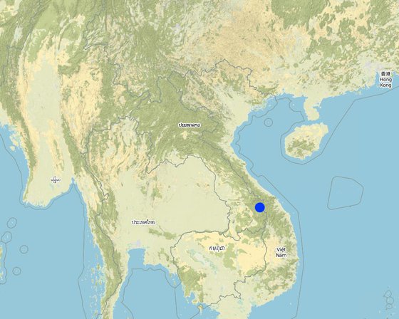
Location: Tangnong village, Dakchaung district, Sekong province, Lao People's Democratic Republic

No. of Technology sites analysed: 2-10 sites

Geo-reference of selected sites
  • 107.241, 15.67801

Spread of the Technology: applied at specific points/ concentrated on a small area

In a permanently protected area?:

Date of implementation: 2003; 10-50 years ago

Type of introduction
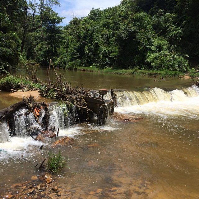
The small dynamo installation in the dyke for community (Khampheng Bounyavong)
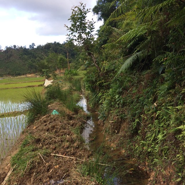
The canal from the main dyke to the irrigated rice field (Khampheng Bounyavong)

Classification of the Technology

Main purpose
  • improve production
  • reduce, prevent, restore land degradation
  • conserve ecosystem
  • protect a watershed/ downstream areas – in combination with other Technologies
  • preserve/ improve biodiversity
  • reduce risk of disasters
  • adapt to climate change/ extremes and its impacts
  • mitigate climate change and its impacts
  • create beneficial economic impact
  • create beneficial social impact
Land use

  • Cropland
    • Annual cropping: cereals - rice (wetland), vegetables - other
    Number of growing seasons per year: 1
  • Waterways, waterbodies, wetlands - Ponds, dams
    Main products/ services: paddy rice, electric generation

Water supply
  • rainfed
  • mixed rainfed-irrigated
  • full irrigation

Purpose related to land degradation
  • prevent land degradation
  • reduce land degradation
  • restore/ rehabilitate severely degraded land
  • adapt to land degradation
  • not applicable
Degradation addressed
  • chemical soil deterioration - Cn: fertility decline and reduced organic matter content (not caused by erosion)
  • water degradation - Ha: aridification
SLM group
  • water harvesting
  • energy efficiency technologies
  • ecosystem-based disaster risk reduction
SLM measures
  • structural measures - S5: Dams, pans, ponds, S10: Energy saving measures

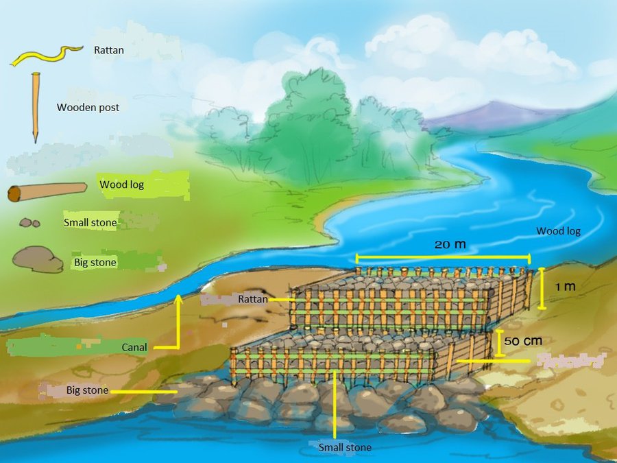
Technical drawing

Technical specifications
The posts have length of about 1.5 m that are fixed into the ground water bottom at a deepness of around 50 cm.
There are two dike rows, each have width of 1 m and a length of approximattly 25 m (corresponding to the width of the stream)
The space between the two dikes is 1 m, the slope angle is 3-5 %
The beneficial area of these dikes is 10 ha of irrigated rice.
The construction material used consists of wooden post (diameters 10 cm and/a length 1.5 m), wood logs with of 20 cm diameter and length of 4-5 m, rattan used to thigten the wood logs with the post. Soil and small stone are put in the back of the wood logs and between the space of the two structures to limit water penetration. Then, also big stones are placed in front of the wood posts to stabilize the structure of the dikes.
After completion of the dike construction, a canal above the upper dike has to be digged to drain the accumulated water into the rice field.
Author: Khampheng Bounyavong

Establishment and maintenance: activities, inputs and costs

Calculation of inputs and costs
  • Costs are calculated: per Technology unit (unit: one dam volume, length: width 1m, height 1m, depth 50 cm in the ground, length 25 m cross the steam)
  • Currency used for cost calculation: Kip
  • Exchange rate (to USD): 1 USD = 8000.0 Kip
  • Average wage cost of hired labour per day: 50 000 kip
Most important factors affecting the costs
The labour for collecting the wood logs and the labour for the construction of the dike.
Establishment activities
  1. Find dead wood logs (Timing/ frequency: None)
  2. Collect and prepare the rattan to tighten the wood (Timing/ frequency: None)
  3. Collect the stones and rocks (Timing/ frequency: None)
  4. Dyke installation (Timing/ frequency: None)
Establishment inputs and costs (per one dam)
Specify input Unit Quantity Costs per Unit (Kip) Total costs per input (Kip) % of costs borne by land users
Labour
Labour person 48.0 50000.0 2400000.0 100.0
Equipment
Hummer piece 4.0 150000.0 600000.0 100.0
Axes piece 10.0 100000.0 1000000.0 100.0
Hoe piece 15.0 40000.0 600000.0 100.0
Shovel piece 10.0 50000.0 500000.0 100.0
Knife piece 10.0 25000.0 250000.0 100.0
Construction material
Wood logs piece 10.0 50000.0 500000.0 100.0
Rattan line 200.0 20000.0 4000000.0 100.0
Stones m3 50.0 40000.0 2000000.0 100.0
Wood post piece 10.0 10000.0 100000.0 100.0
Total costs for establishment of the Technology 11'950'000.0
Total costs for establishment of the Technology in USD 1'493.75
Maintenance activities
  1. Find the wood logs to repair the dikes (Timing/ frequency: None)
  2. Prepare the rattan to refix the logs with the posts (Timing/ frequency: None)
  3. Collect the stones to imrove the stabilize the dikes (Timing/ frequency: None)
  4. Repair the dike (Timing/ frequency: None)
Maintenance inputs and costs (per one dam)
Specify input Unit Quantity Costs per Unit (Kip) Total costs per input (Kip) % of costs borne by land users
Labour
Labor person 48.0 50000.0 2400000.0 100.0
Construction material
Wood logs piece 10.0 50000.0 500000.0 100.0
Rattan line 200.0 10000.0 2000000.0 100.0
Stones m3 10.0 50000.0 500000.0 100.0
Wood post piece 10.0 10000.0 100000.0 100.0
Total costs for maintenance of the Technology 5'500'000.0
Total costs for maintenance of the Technology in USD 687.5

Natural environment

Average annual rainfall
  • < 250 mm
  • 251-500 mm
  • 501-750 mm
  • 751-1,000 mm
  • 1,001-1,500 mm
  • 1,501-2,000 mm
  • 2,001-3,000 mm
  • 3,001-4,000 mm
  • > 4,000 mm
Agro-climatic zone
  • humid
  • sub-humid
  • semi-arid
  • arid
Specifications on climate
Average annual rainfall in mm: 870.0
The driest month is January, with 14 mm of rainfall. In July, the precipitation reaches its peak. Heavy rain is between July-September. Total rain fall is about 3200 mm/year
Name of the meteorological station: Natural resource office
The warmest month of the year is May, with an average temperature of 22.3 °C. With16.6 °C on average, January is the coldest month of the year.
Slope
  • flat (0-2%)
  • gentle (3-5%)
  • moderate (6-10%)
  • rolling (11-15%)
  • hilly (16-30%)
  • steep (31-60%)
  • very steep (>60%)
Landforms
  • plateau/plains
  • ridges
  • mountain slopes
  • hill slopes
  • footslopes
  • valley floors
Altitude
  • 0-100 m a.s.l.
  • 101-500 m a.s.l.
  • 501-1,000 m a.s.l.
  • 1,001-1,500 m a.s.l.
  • 1,501-2,000 m a.s.l.
  • 2,001-2,500 m a.s.l.
  • 2,501-3,000 m a.s.l.
  • 3,001-4,000 m a.s.l.
  • > 4,000 m a.s.l.
Technology is applied in
  • convex situations
  • concave situations
  • not relevant
Soil depth
  • very shallow (0-20 cm)
  • shallow (21-50 cm)
  • moderately deep (51-80 cm)
  • deep (81-120 cm)
  • very deep (> 120 cm)
Soil texture (topsoil)
  • coarse/ light (sandy)
  • medium (loamy, silty)
  • fine/ heavy (clay)
Soil texture (> 20 cm below surface)
  • coarse/ light (sandy)
  • medium (loamy, silty)
  • fine/ heavy (clay)
Topsoil organic matter content
  • high (>3%)
  • medium (1-3%)
  • low (<1%)
Groundwater table
  • on surface
  • < 5 m
  • 5-50 m
  • > 50 m
Availability of surface water
  • excess
  • good
  • medium
  • poor/ none
Water quality (untreated)
  • good drinking water
  • poor drinking water (treatment required)
  • for agricultural use only (irrigation)
  • unusable
Water quality refers to:
Is salinity a problem?
  • Ja
  • Nee

Occurrence of flooding
  • Ja
  • Nee
Species diversity
  • high
  • medium
  • low
Habitat diversity
  • high
  • medium
  • low

Characteristics of land users applying the Technology

Market orientation
  • subsistence (self-supply)
  • mixed (subsistence/ commercial)
  • commercial/ market
Off-farm income
  • less than 10% of all income
  • 10-50% of all income
  • > 50% of all income
Relative level of wealth
  • very poor
  • poor
  • average
  • rich
  • very rich
Level of mechanization
  • manual work
  • animal traction
  • mechanized/ motorized
Sedentary or nomadic
  • Sedentary
  • Semi-nomadic
  • Nomadic
Individuals or groups
  • individual/ household
  • groups/ community
  • cooperative
  • employee (company, government)
Gender
  • women
  • men
Age
  • children
  • youth
  • middle-aged
  • elderly
Area used per household
  • < 0.5 ha
  • 0.5-1 ha
  • 1-2 ha
  • 2-5 ha
  • 5-15 ha
  • 15-50 ha
  • 50-100 ha
  • 100-500 ha
  • 500-1,000 ha
  • 1,000-10,000 ha
  • > 10,000 ha
Scale
  • small-scale
  • medium-scale
  • large-scale
Land ownership
  • state
  • company
  • communal/ village
  • group
  • individual, not titled
  • individual, titled
Land use rights
  • open access (unorganized)
  • communal (organized)
  • leased
  • individual
Water use rights
  • open access (unorganized)
  • communal (organized)
  • leased
  • individual
Access to services and infrastructure
health

poor
good
education

poor
good
technical assistance

poor
good
employment (e.g. off-farm)

poor
good
markets

poor
good
energy

poor
good
roads and transport

poor
good
drinking water and sanitation

poor
good
financial services

poor
good

Impacts

Socio-economic impacts
crop quality
decreased
increased

Quantity before SLM: 8 tons/ha
Quantity after SLM: 2 tons/ha
Before gold mining company entered in the area the yield of rice raised to 8 tons/ha due to the aboundant irrigation water caused by the dike construction. But unfortunately actually (in 2017), due to gold excavating rice yield decreased to 2 tons/ha, only.

energy generation (e.g. hydro, bio)
decreased
increased


Some households also install dynamo ( electric generator ) with production capacity of 1 Kwh.

irrigation water availability
decreased
increased


Before, water for cultivation was insufficient especially during dry season as the stream water level was too low , after the weir construction the stream water level got high enough to fill the canal leading to the production area all-year round.

Socio-cultural impacts
conflict mitigation
worsened
improved


Before dyke construction the villagers tried to bring water to their fields by small individual canals during dry season. This caused competition and conflicts on scares water scarcity. After the communal wire construction the conflicts situation have been been improved.

Ecological impacts
drought impacts
increased
decreased


Even during dry season (and drought events) the farmers bring enough the water to the fields.

Off-site impacts
reliable and stable stream flows in dry season (incl. low flows)
reduced
increased


The weir stopped to some extent the natural water flow. This causes slower but still regular downstream water flow during dry season.

Cost-benefit analysis

Benefits compared with establishment costs
Short-term returns
very negative
very positive

Long-term returns
very negative
very positive

Benefits compared with maintenance costs
Short-term returns
very negative
very positive

Long-term returns
very negative
very positive

Climate change

Gradual climate change
annual temperature increase

not well at all
very well
seasonal temperature decrease

not well at all
very well
Season: dry season
seasonal rainfall increase

not well at all
very well
Season: wet/ rainy season
None increase

not well at all
very well
Climate-related extremes (disasters)
local hailstorm

not well at all
very well
extreme winter conditions

not well at all
very well
flash flood

not well at all
very well
epidemic diseases

not well at all
very well
insect/ worm infestation

not well at all
very well
Other climate-related consequences
extended growing period

not well at all
very well

Adoption and adaptation

Percentage of land users in the area who have adopted the Technology
  • single cases/ experimental
  • 1-10%
  • 11-50%
  • > 50%
Of all those who have adopted the Technology, how many have done so without receiving material incentives?
  • 0-10%
  • 11-50%
  • 51-90%
  • 91-100%
Has the Technology been modified recently to adapt to changing conditions?
  • Ja
  • Nee
To which changing conditions?
  • climatic change/ extremes
  • changing markets
  • labour availability (e.g. due to migration)

Conclusions and lessons learnt

Strengths: land user's view
  • Inputs are economically beneficial.
  • Provides a reliable water supply for agricultural activities.
  • Electricity can be generated with a small dynamo.
Strengths: compiler’s or other key resource person’s view
  • Mitigates water use conflicts which could occur in the village.
Weaknesses/ disadvantages/ risks: land user's viewhow to overcome
  • It is only possible to construct a temporary weir due to the low quality of locally available materials
  • A great deal of time needs to be invested in annual maintenance work.
Weaknesses/ disadvantages/ risks: compiler’s or other key resource person’s viewhow to overcome

References

Compiler
  • kang phanvongsa
Editors
  • Pasalath Khounsy
  • Bounthanom Bouahom
  • anousit namsena
Reviewer
  • Nicole Harari
  • viengsavanh phimphachanhvongsod
  • Stephanie Jaquet
  • Alexandra Gavilano
Date of documentation: Mei 19, 2017
Last update: Mei 10, 2019
Resource persons
Full description in the WOCAT database
Linked SLM data
Documentation was faciliated by
Institution Project
This work is licensed under Creative Commons Attribution-NonCommercial-ShareaAlike 4.0 International