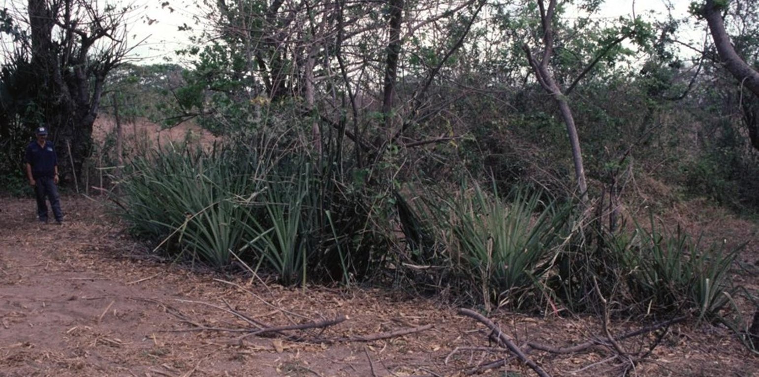
A fully developed check dam: The stem cuttings - in this case associated with Bromelia pinguin - have grown to form a dense living barrier, and the area behind the dam has become level. (Mats Gurtner)

Check dams from stem cuttings (Nicaragua)

Diques de postes prendedizos (Spanish)

Description

Gully rehabilitation by check dams made of stem cuttings from trees. These living barriers retard concentrated runoff and fill up the gullies gradually with sediment.

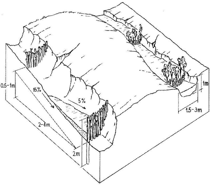
Stem cuttings from specific tree species have the ability to strike roots and continue growing after being planted into the earth. In this case study local species have been used to create check dams in gullies: these include jinocuebo (Simaroubaceaes bombacaceaes, and also jobo, tiguilote, pochote from the same family). Other suitable species are jocote (Spondias purpurea) and madero negro (Gliricidia sepium). As an option the pinapple-like piñuela (Bromelia pinguin) can be planted in association with the stem cuttings to further reinforce the system. Tree stems are cut into pieces 5-15 cm thick and 1.5-2.5 m long, depending on the depth of the gully. The cuttings are planted to half of their length, and formed into semi-circular barriers (see diagram). The dams retard runoff and thus retain eroded sediment. Spacing between dams depends on the gradient of the gully bed. For example on a 15% slope it is recommended to build a dam every 4 meters (see spacing under establishment activities). Between dams, the gully gradually fills up with eroded soil, the speed of the runoff is further reduced and agricultural land that has been divided by the gully is reconnected. Large and deep gullies may change over time into a sequence of narrow fertile terraces where crops can be grown.

However, the check dams should be seen as part of an integrated catchment management and protection plan, and thus be supported by other SWC measures on the lateral slopes, such as retention ditches and/or live barriers laid out along the contour. Erosion and runoff control on the sides of each gully is an essential part of the rehabilitation process. These check dams of rooted poles are more robust and durable than stone dams in soils of sandy/ loamy texture. On moderate and steep slopes a combination of stem cutting and stone dams is recommended.

After two to three years the barriers should be pruned - yielding wood and fodder. Dead poles should be replaced and the dam widened if necessary.

In this case study the dams are constructed in a semi-arid region with erratic rainfall where gullies are common on agricultural land, be it cropland or grazing land. The land users are mainly peasant farmers, growing crops for subsistence on smallholdings, and living in very poor conditions. This system of gully rehabilitation is promoted by an NGO entitled ‘Asociación Tierra y Vida’ through farmerto-farmer (campesino a campesino) extension.

Location

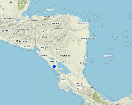
Location: Carazo, Nicaragua, Santa Teresa, Paso de la Solera, Nicaragua

No. of Technology sites analysed:

Geo-reference of selected sites
  • -86.19921, 11.72944

Spread of the Technology:

In a permanently protected area?:

Date of implementation: less than 10 years ago (recently)

Type of introduction
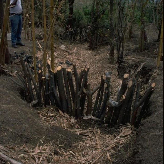
Check dams made of rooted tree stems reduce the speed of runoff water in the gully and trap sediment. (Mats Gurtner)

Classification of the Technology

Main purpose
  • improve production
  • reduce, prevent, restore land degradation
  • conserve ecosystem
  • protect a watershed/ downstream areas – in combination with other Technologies
  • preserve/ improve biodiversity
  • reduce risk of disasters
  • adapt to climate change/ extremes and its impacts
  • mitigate climate change and its impacts
  • create beneficial economic impact
  • create beneficial social impact
Land use

  • Cropland
    • Annual cropping
  • Grazing land

Water supply
  • rainfed
  • mixed rainfed-irrigated
  • full irrigation

Purpose related to land degradation
  • prevent land degradation
  • reduce land degradation
  • restore/ rehabilitate severely degraded land
  • adapt to land degradation
  • not applicable
Degradation addressed
  • soil erosion by water - Wg: gully erosion/ gullying
SLM group
  • cross-slope measure
SLM measures
  • vegetative measures - V5: Others
  • structural measures - S4: Level ditches, pits, S5: Dams, pans, ponds

Technical drawing

Technical specifications
Stem cuttings planted in gullies to form living check dams: recently planted (left) and cuttings that have begun to take root and sprout, resulting in the gully becoming filled with trapped sediment (right).

Technical knowledge required for field staff / advisors: low
Technical knowledge required for land users: moderate
Main technical functions: control of concentrated runoff: retain / trap, levelling of land
Secondary technical functions: reduction of slope angle, reduction of slope length

Construction material (wood): jinocuebo (Simaroubaceaes bombacaceaes, and also jobo, tiguilote, pochote from the same family), j
Slope (which determines the spacing indicated above): 15%
Author: Mats Gurtner

Establishment and maintenance: activities, inputs and costs

Calculation of inputs and costs
  • Costs are calculated:
  • Currency used for cost calculation: n.a.
  • Exchange rate (to USD): 1 USD = n.a
  • Average wage cost of hired labour per day: n.a
Most important factors affecting the costs
The wood (for poles) belongs to the land users themselves, thus the ‘cost’ does not involve purchase.
Establishment activities
  1. Calculate and mark spacing between structures. (Timing/ frequency: efore rainy season (April/May))
  2. Cut poles out of selected local trees (diameter: 5–15 cm,length: 1.5–2.5 m depending on gully depth). (Timing/ frequency: before rainy season (April/May))
  3. Dig small semi-circular ditches at the gully bottom (the depth of theditch is half the length of the cuttings). (Timing/ frequency: before rainy season (April/May))
  4. Plant the cuttings vertically into the ditch; put the thicker cuttingsin the middle of the gully where runoff velocity is higher. (Timing/ frequency: efore rainy season (April/May))
  5. Fill ditch with excavated earth to fix the cuttings. (Timing/ frequency: before rainy season (April/May))
  6. Water to encourage rooting. (Timing/ frequency: before rainy season (April/May))
Establishment inputs and costs
Specify input Unit Quantity Costs per Unit (n.a.) Total costs per input (n.a.) % of costs borne by land users
Labour
labour ha 1.0 100.0 100.0 100.0
Equipment
tools ha 1.0 20.0 20.0
wheelbarrow ha 1.0 10.0 10.0 100.0
Construction material
wood ha 1.0 60.0 60.0 100.0
Total costs for establishment of the Technology 190.0
Total costs for establishment of the Technology in USD 190.0
Maintenance activities
  1. Biotrampas: pruning the trees (Timing/ frequency: every three years.)
  2. Cut-off drains: clearing of sediment, cutting bushes and grasses. (Timing/ frequency: None)
  3. Stone check dams: pruning trees and bushes every three years. After fullsedimentation, the dam may be increased in height. (Timing/ frequency: None)
  4. Wooden check dams: pruning trees and bushes (Timing/ frequency: every three years.)
Maintenance inputs and costs
Specify input Unit Quantity Costs per Unit (n.a.) Total costs per input (n.a.) % of costs borne by land users
Labour
labour ha 1.0 30.0 30.0 100.0
Construction material
wood ha 1.0 5.0 5.0 100.0
Total costs for maintenance of the Technology 35.0
Total costs for maintenance of the Technology in USD 35.0

Natural environment

Average annual rainfall
  • < 250 mm
  • 251-500 mm
  • 501-750 mm
  • 751-1,000 mm
  • 1,001-1,500 mm
  • 1,501-2,000 mm
  • 2,001-3,000 mm
  • 3,001-4,000 mm
  • > 4,000 mm
Agro-climatic zone
  • humid
  • sub-humid
  • semi-arid
  • arid
Specifications on climate
n.a.
Slope
  • flat (0-2%)
  • gentle (3-5%)
  • moderate (6-10%)
  • rolling (11-15%)
  • hilly (16-30%)
  • steep (31-60%)
  • very steep (>60%)
Landforms
  • plateau/plains
  • ridges
  • mountain slopes
  • hill slopes
  • footslopes
  • valley floors
Altitude
  • 0-100 m a.s.l.
  • 101-500 m a.s.l.
  • 501-1,000 m a.s.l.
  • 1,001-1,500 m a.s.l.
  • 1,501-2,000 m a.s.l.
  • 2,001-2,500 m a.s.l.
  • 2,501-3,000 m a.s.l.
  • 3,001-4,000 m a.s.l.
  • > 4,000 m a.s.l.
Technology is applied in
  • convex situations
  • concave situations
  • not relevant
Soil depth
  • very shallow (0-20 cm)
  • shallow (21-50 cm)
  • moderately deep (51-80 cm)
  • deep (81-120 cm)
  • very deep (> 120 cm)
Soil texture (topsoil)
  • coarse/ light (sandy)
  • medium (loamy, silty)
  • fine/ heavy (clay)
Soil texture (> 20 cm below surface)
  • coarse/ light (sandy)
  • medium (loamy, silty)
  • fine/ heavy (clay)
Topsoil organic matter content
  • high (>3%)
  • medium (1-3%)
  • low (<1%)
Groundwater table
  • on surface
  • < 5 m
  • 5-50 m
  • > 50 m
Availability of surface water
  • excess
  • good
  • medium
  • poor/ none
Water quality (untreated)
  • good drinking water
  • poor drinking water (treatment required)
  • for agricultural use only (irrigation)
  • unusable
Is salinity a problem?
  • Ja
  • Nee

Occurrence of flooding
  • Ja
  • Nee
Species diversity
  • high
  • medium
  • low
Habitat diversity
  • high
  • medium
  • low

Characteristics of land users applying the Technology

Market orientation
  • subsistence (self-supply)
  • mixed (subsistence/ commercial)
  • commercial/ market
Off-farm income
  • less than 10% of all income
  • 10-50% of all income
  • > 50% of all income
Relative level of wealth
  • very poor
  • poor
  • average
  • rich
  • very rich
Level of mechanization
  • manual work
  • animal traction
  • mechanized/ motorized
Sedentary or nomadic
  • Sedentary
  • Semi-nomadic
  • Nomadic
Individuals or groups
  • individual/ household
  • groups/ community
  • cooperative
  • employee (company, government)
Gender
  • women
  • men
Age
  • children
  • youth
  • middle-aged
  • elderly
Area used per household
  • < 0.5 ha
  • 0.5-1 ha
  • 1-2 ha
  • 2-5 ha
  • 5-15 ha
  • 15-50 ha
  • 50-100 ha
  • 100-500 ha
  • 500-1,000 ha
  • 1,000-10,000 ha
  • > 10,000 ha
Scale
  • small-scale
  • medium-scale
  • large-scale
Land ownership
  • state
  • company
  • communal/ village
  • group
  • individual, not titled
  • individual, titled
Land use rights
  • open access (unorganized)
  • communal (organized)
  • leased
  • individual
Water use rights
  • open access (unorganized)
  • communal (organized)
  • leased
  • individual
Access to services and infrastructure

Impacts

Socio-economic impacts
Crop production
decreased
increased


where gullies planted

fodder production
decreased
increased


eg madero negro=Gliricidium sepium

wood production
decreased
increased


medium term

farm income
decreased
increased

workload
increased
decreased


during establishment phase

Socio-cultural impacts
community institutions
weakened
strengthened

conflict mitigation
worsened
improved

improves relationships between land users
decreased
increased

Ecological impacts
soil moisture
decreased
increased

soil loss
increased
decreased

nutrient cycling/ recharge
decreased
increased

Off-site impacts
downstream flooding (undesired)
increased
reduced

downstream siltation
increased
decreased

groundwater/ river pollution
increased
reduced

Cost-benefit analysis

Benefits compared with establishment costs
Short-term returns
very negative
very positive

Long-term returns
very negative
very positive

Benefits compared with maintenance costs
Short-term returns
very negative
very positive

Long-term returns
very negative
very positive

Climate change

-

Adoption and adaptation

Percentage of land users in the area who have adopted the Technology
  • single cases/ experimental
  • 1-10%
  • 11-50%
  • > 50%
Of all those who have adopted the Technology, how many have done so without receiving material incentives?
  • 0-10%
  • 11-50%
  • 51-90%
  • 91-100%
Has the Technology been modified recently to adapt to changing conditions?
  • Ja
  • Nee
To which changing conditions?
  • climatic change/ extremes
  • changing markets
  • labour availability (e.g. due to migration)

Conclusions and lessons learnt

Strengths: land user's view
Strengths: compiler’s or other key resource person’s view
  • Facilitated land management: area is no longer divided by gullies
  • Retards runoff speed: decreases erosion
  • Accumulation of fertile earth above the check dams, possibility of growing crops on ‘terraces’ between the structures
  • Increased soil moisture
Weaknesses/ disadvantages/ risks: land user's viewhow to overcome
Weaknesses/ disadvantages/ risks: compiler’s or other key resource person’s viewhow to overcome
  • The check dams used alone as SWC measure may not be adequate to withstand concentrated runoff It is important to combine this technology with other SWC practices (e.g. retention ditches on slopes at both sides of gully, live fences, etc).
  • Only likely to be applied where land use rights are guaranteed.
  • Labour intensive.

References

Compiler
  • Mathias Gurtner
Editors
Reviewer
  • Deborah Niggli
  • Alexandra Gavilano
Date of documentation: Maart 17, 2011
Last update: Junie 6, 2019
Resource persons
Full description in the WOCAT database
Linked SLM data
Documentation was faciliated by
Institution Project
Key references
  • Gurdiel G . La construcción de diques. Tierra Fresca, Simas-Enlace, Managua. 1993.:
  • Guía Técnica de Conservación de Suelos y Agua. PASOLAC, Managua. 2000.:
  • LUPE . Manual Práctico de Manejo de Suelos en Laderas. Secretaría de Recursos Naturales, Tegucigalpa, Honduras. 1994.:
This work is licensed under Creative Commons Attribution-NonCommercial-ShareaAlike 4.0 International