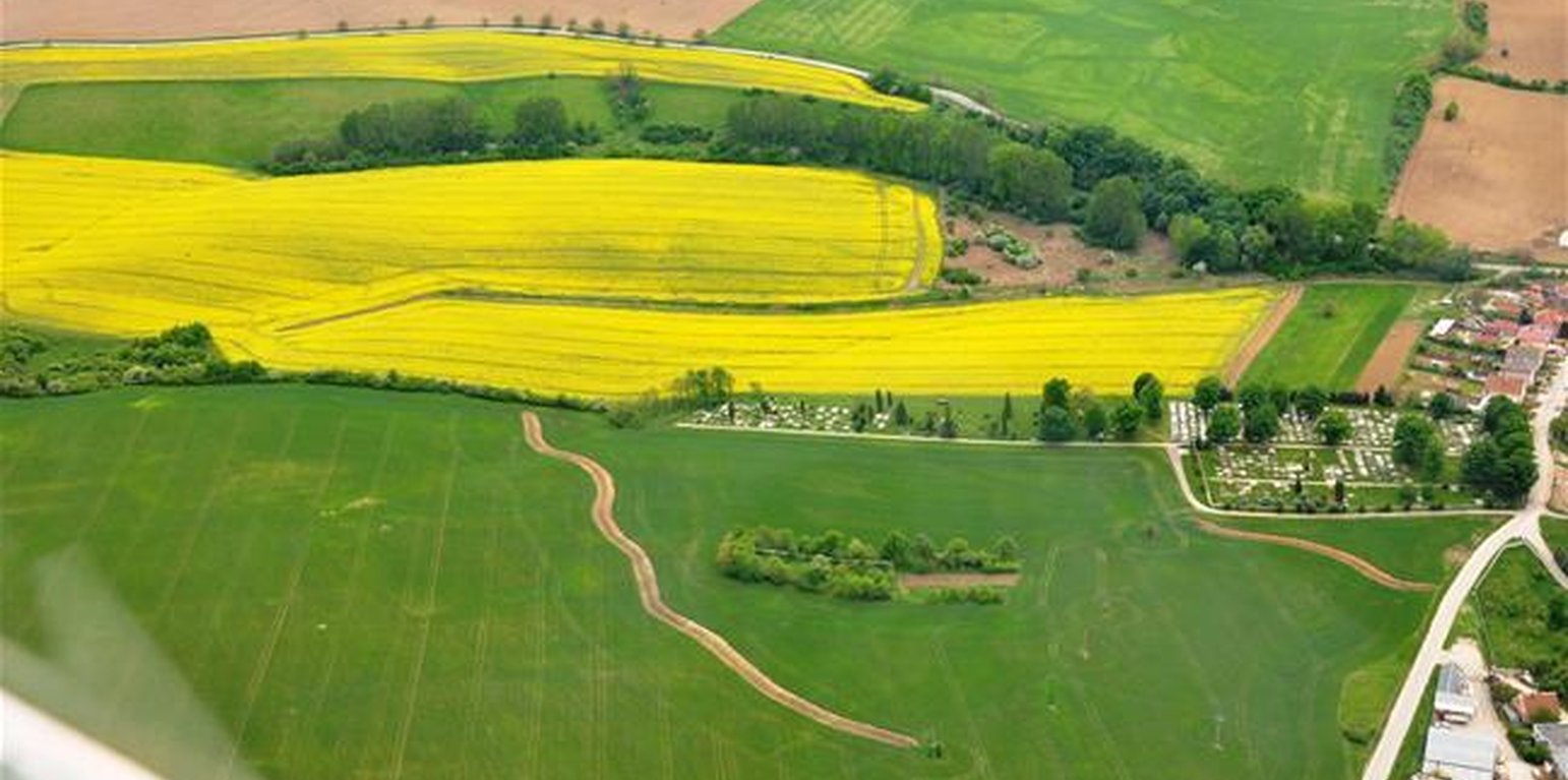
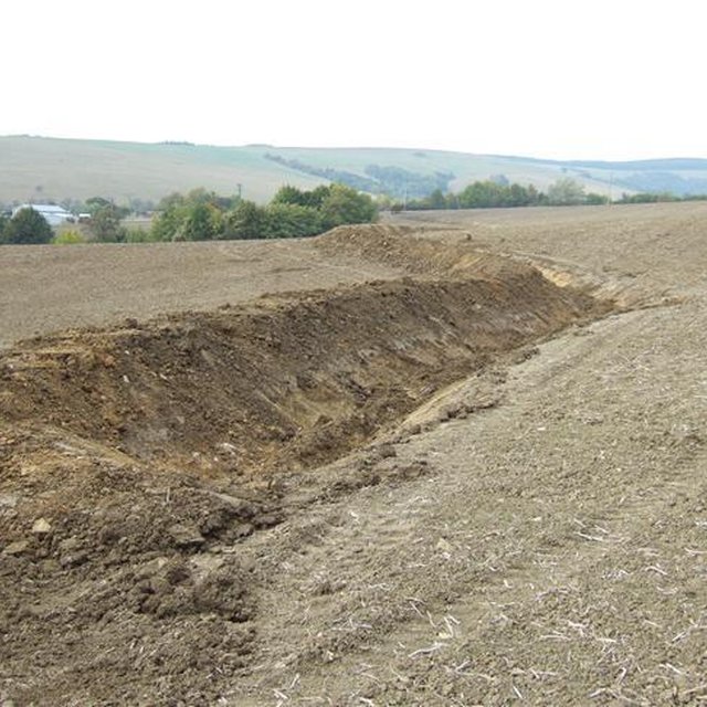
The photos show the level ditches that retain water on the field. ((http://www.obecsobotiste.sk/Vodozadrzne-opatrenia.aspx))

Level ditches in cropland (Slovakia)

Záchytné pásy na poľnohospodárskej pôde (Slovak language)

Description

Conservation measures for eroded cropland. The technology contains level ditches of various lengths, which are digged along a contour.

The structural measures are characterized as small technical structures to control and slow down surface runoff, created after extreme rainfall. The ditch is digged across the slope (along the contour) according to the terrain. Along the four of dithes there were also vegetative strips that should protect and retain rainfall.

Purpose of the Technology: Some damage has been observed on the farmland during storm rainfalls, long-lasting rainfalls, and periods of melting snow. The aim of the conservation measures is to eliminate hazards and damage to health and the economy, to improve the accumulation and infiltration of water into the soil, and to retard the surface runoff on the farmland.

Establishment / maintenance activities and inputs: There are 7 ditches in the area (2842 m in total/ 23873 m3). In the locality of Padelky there are level ditches with lengths of 160 m + 320 m+ 830m = 1310 m; in the locality of Kubíny there are level ditches with lengths of 500 m + 100 m + 175 m = 775 m; in the locality of Šlachovec there is one ditch with the length of 750 m. The total water retention volume is 23873 m3. The ditches are in the shape of a trapezoid with a base width of 1 m, a height according to the terrain, and a slope of 1:1.5 while the digged soil is moved to the lower part of the ditch.

Natural / human environment: Sobotište is a village in the Teplica river basin; it is situated near the town of Senica in the Trnava region of western Slovakia. It is located in a valley at the foothills of the White Carpathians, which are part of the Carpathian Flysch Belt. The sedimentary flysh rocks are erodible, disintegrable, and sensitive to erosion.

Location

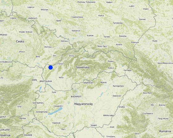
Location: Sobotište, Slovakia, Slovakia

No. of Technology sites analysed:

Geo-reference of selected sites
  • 17.41206, 48.73606

Spread of the Technology:

In a permanently protected area?:

Date of implementation:

Type of introduction
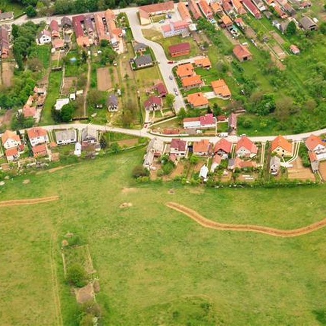
The photo shows two ditches. ((http://www.obecsobotiste.sk/Vodozadrzne-opatrenia.aspx))
This photo shows the process of level ditch realization. ((http://www.obecsobotiste.sk/Vodozadrzne-opatrenia.aspx))

Classification of the Technology

Main purpose
  • improve production
  • reduce, prevent, restore land degradation
  • conserve ecosystem
  • protect a watershed/ downstream areas – in combination with other Technologies
  • preserve/ improve biodiversity
  • reduce risk of disasters
  • adapt to climate change/ extremes and its impacts
  • mitigate climate change and its impacts
  • create beneficial economic impact
  • create beneficial social impact
Land use

  • Cropland
    • Annual cropping: oilseed crops - sunflower, rapeseed, other
    Number of growing seasons per year: 1
Water supply
  • rainfed
  • mixed rainfed-irrigated
  • full irrigation

Purpose related to land degradation
  • prevent land degradation
  • reduce land degradation
  • restore/ rehabilitate severely degraded land
  • adapt to land degradation
  • not applicable
Degradation addressed
  • soil erosion by water - Wt: loss of topsoil/ surface erosion, Wo: offsite degradation effects
SLM group
  • cross-slope measure
SLM measures
  • vegetative measures - V2: Grasses and perennial herbaceous plants
  • structural measures - S4: Level ditches, pits

Technical drawing

Technical specifications

Establishment and maintenance: activities, inputs and costs

Calculation of inputs and costs
  • Costs are calculated:
  • Currency used for cost calculation: Eur
  • Exchange rate (to USD): 1 USD = 0.88 Eur
  • Average wage cost of hired labour per day: n.a
Most important factors affecting the costs
The costs differ from project to project, it depends on the design, building company atc.
Establishment activities
  1. Digging of the ditch for 600 mm width (Timing/ frequency: None)
  2. Adjustment of the ditch´s embankment (Timing/ frequency: None)
  3. Digging of the ditch for 600-2000 mm width (Timing/ frequency: None)
  4. Digging of the ditch for over 2000 mm width (Timing/ frequency: None)
  5. expert guarantor and planner (Timing/ frequency: None)
  6. Transfer (Timing/ frequency: None)
  7. Vegetative strips next to the ditch in 40 m width. Red clover. (Timing/ frequency: spring)
Establishment inputs and costs
Specify input Unit Quantity Costs per Unit (Eur) Total costs per input (Eur) % of costs borne by land users
Labour
Digging of the ditch for 600 mm width m3 9.9 18.14 179.59
Adjustment of the ditch´s embankment m2 3861.0 0.82 3166.02
Digging of the ditch for 600-2000 mm width m2 5253.0 10.24 53790.72
or Digging of the ditch for over 2000 mm width m2 5253.0 1.26 6618.78
Plant material
Seeds for vegetative strips next to the ditch in 40 m width. Red clover. kg 704.0 8.15 5737.6
Other
expert guarantor and planner person 1.0 3062.61 3062.61
Transfer t 58.655 46.11 2704.58
Total costs for establishment of the Technology 75'259.9
Total costs for establishment of the Technology in USD 85'522.61
Maintenance activities
n.a.

Natural environment

Average annual rainfall
  • < 250 mm
  • 251-500 mm
  • 501-750 mm
  • 751-1,000 mm
  • 1,001-1,500 mm
  • 1,501-2,000 mm
  • 2,001-3,000 mm
  • 3,001-4,000 mm
  • > 4,000 mm
Agro-climatic zone
  • humid
  • sub-humid
  • semi-arid
  • arid
Specifications on climate
Thermal climate class: temperate
Slope
  • flat (0-2%)
  • gentle (3-5%)
  • moderate (6-10%)
  • rolling (11-15%)
  • hilly (16-30%)
  • steep (31-60%)
  • very steep (>60%)
Landforms
  • plateau/plains
  • ridges
  • mountain slopes
  • hill slopes
  • footslopes
  • valley floors
Altitude
  • 0-100 m a.s.l.
  • 101-500 m a.s.l.
  • 501-1,000 m a.s.l.
  • 1,001-1,500 m a.s.l.
  • 1,501-2,000 m a.s.l.
  • 2,001-2,500 m a.s.l.
  • 2,501-3,000 m a.s.l.
  • 3,001-4,000 m a.s.l.
  • > 4,000 m a.s.l.
Technology is applied in
  • convex situations
  • concave situations
  • not relevant
Soil depth
  • very shallow (0-20 cm)
  • shallow (21-50 cm)
  • moderately deep (51-80 cm)
  • deep (81-120 cm)
  • very deep (> 120 cm)
Soil texture (topsoil)
  • coarse/ light (sandy)
  • medium (loamy, silty)
  • fine/ heavy (clay)
Soil texture (> 20 cm below surface)
  • coarse/ light (sandy)
  • medium (loamy, silty)
  • fine/ heavy (clay)
Topsoil organic matter content
  • high (>3%)
  • medium (1-3%)
  • low (<1%)
Groundwater table
  • on surface
  • < 5 m
  • 5-50 m
  • > 50 m
Availability of surface water
  • excess
  • good
  • medium
  • poor/ none
Water quality (untreated)
  • good drinking water
  • poor drinking water (treatment required)
  • for agricultural use only (irrigation)
  • unusable
Water quality refers to:
Is salinity a problem?
  • Ja
  • Nee

Occurrence of flooding
  • Ja
  • Nee
Species diversity
  • high
  • medium
  • low
Habitat diversity
  • high
  • medium
  • low

Characteristics of land users applying the Technology

Market orientation
  • subsistence (self-supply)
  • mixed (subsistence/ commercial)
  • commercial/ market
Off-farm income
  • less than 10% of all income
  • 10-50% of all income
  • > 50% of all income
Relative level of wealth
  • very poor
  • poor
  • average
  • rich
  • very rich
Level of mechanization
  • manual work
  • animal traction
  • mechanized/ motorized
Sedentary or nomadic
  • Sedentary
  • Semi-nomadic
  • Nomadic
Individuals or groups
  • individual/ household
  • groups/ community
  • cooperative
  • employee (company, government)
Gender
  • women
  • men
Age
  • children
  • youth
  • middle-aged
  • elderly
Area used per household
  • < 0.5 ha
  • 0.5-1 ha
  • 1-2 ha
  • 2-5 ha
  • 5-15 ha
  • 15-50 ha
  • 50-100 ha
  • 100-500 ha
  • 500-1,000 ha
  • 1,000-10,000 ha
  • > 10,000 ha
Scale
  • small-scale
  • medium-scale
  • large-scale
Land ownership
  • state
  • company
  • communal/ village
  • group
  • individual, not titled
  • individual, titled
Land use rights
  • open access (unorganized)
  • communal (organized)
  • leased
  • individual
Water use rights
  • open access (unorganized)
  • communal (organized)
  • leased
  • individual
Access to services and infrastructure
health

poor
x
good
education

poor
x
good
technical assistance

poor
x
good
employment (e.g. off-farm)

poor
x
good
markets

poor
x
good
energy

poor
x
good
roads and transport

poor
x
good
drinking water and sanitation

poor
x
good
financial services

poor
x
good

Impacts

Socio-economic impacts
Crop production
decreased
x
increased

Socio-cultural impacts
Improved livelihoods and human well-being
decreased
x
increased


The technology decreased risk of the mud flows that are capable of destroying homes, washing out roads, knocking down trees, and obstructing roadways.

Ecological impacts
surface runoff
increased
x
decreased

soil cover
reduced
x
improved

soil loss
increased
x
decreased

Risk of mud flood
improved
x
reduced

Hazard towards averse events
improved
x
reduced

Off-site impacts
damage on public/ private infrastructure
increased
x
reduced


Reduced risk of flooding and damage of the gardens and household.
Reduced the hazards and damage of the surrounding area by heavy rainfall events.

Cost-benefit analysis

Benefits compared with establishment costs
Short-term returns
very negative
x
very positive

Long-term returns
very negative
x
very positive

Benefits compared with maintenance costs
Short-term returns
very negative
x
very positive

Long-term returns
very negative
x
very positive

There were no maintanance required so far.

Climate change

Gradual climate change
annual temperature increase

not well at all
x
very well
Climate-related extremes (disasters)
local rainstorm

not well at all
x
very well
local windstorm

not well at all
x
very well
drought

not well at all
x
very well
general (river) flood

not well at all
x
very well
Other climate-related consequences
reduced growing period

not well at all
x
very well

Adoption and adaptation

Percentage of land users in the area who have adopted the Technology
  • single cases/ experimental
  • 1-10%
  • 11-50%
  • > 50%
Of all those who have adopted the Technology, how many have done so without receiving material incentives?
  • 0-10%
  • 11-50%
  • 51-90%
  • 91-100%
Has the Technology been modified recently to adapt to changing conditions?
  • Ja
  • Nee
To which changing conditions?
  • climatic change/ extremes
  • changing markets
  • labour availability (e.g. due to migration)

Conclusions and lessons learnt

Strengths: land user's view
  • The technology shows to be effective, however the rainfall events that have occured so far were not that extreme as before the implementation.
Strengths: compiler’s or other key resource person’s view
  • The technology is easy to realize. There is no extra knowledge required. The mechanism used to implement the technology is easy to provide.
Weaknesses/ disadvantages/ risks: land user's viewhow to overcome
  • The land users are satisfied with effectivness of the technology.
Weaknesses/ disadvantages/ risks: compiler’s or other key resource person’s viewhow to overcome
  • I don´t see any disadvantage or weekness of the technology.

References

Compiler
  • Zuzana Studvova
Editors
Reviewer
  • Fabian Ottiger
  • Alexandra Gavilano
Date of documentation: April 22, 2015
Last update: Junie 20, 2019
Resource persons
Full description in the WOCAT database
Linked SLM data
Documentation was faciliated by
Institution Project
Key references
  • Project documentation, Hydrotechnológia Bratislava, s.r.o., April 2011:
This work is licensed under Creative Commons Attribution-NonCommercial-ShareaAlike 4.0 International