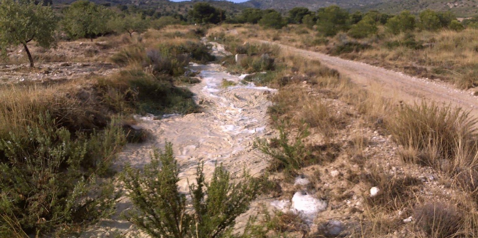
Water flowing through a traditional channel system (acequia) towards almond terraces (Joris de Vente)

Water harvesting from concentrated runoff for irrigation purposes (Spain)

Boqueras (Spanish)

Description

Water harvesting from intermittent streams towards nearby fields and terraces during runoff events.

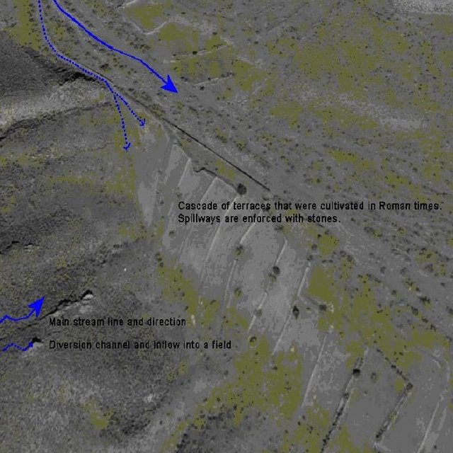
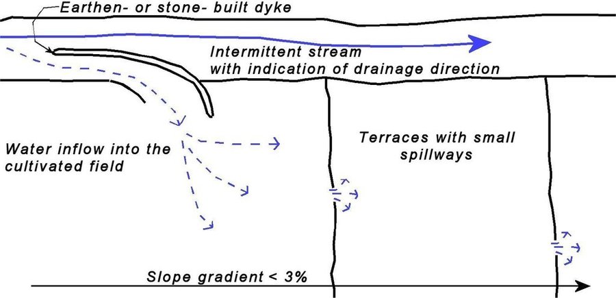
Water shortage is one of the most limiting factors for sustainable agriculture in large parts of SE-Spain. Part of the solution of this problem may come from the restoration of traditional water harvesting structures. Many of these structures were widely used in SE-Spain already during Arab and Roman times, and are also widespread in N-Africa and the Middle East. However, nowadays in Spain many of them are abandoned and forgotten. Here, we describe the technology of a small earthen- or stone- built bund that diverts flood water from intermittent streams towards cultivated fields with almond orchards and/or cereals. The diverted water will temporarily flood the fields and provide the crops with water. Depending on the slope gradient and the amount of water to be harvested, the fields are organised as single terraces, or as a staircase of terraces. On fields with gradients above ~3%, terraces are necessary to reduce the gradient and to retain the floodwater as long as possible. Water is diverted from one terrace to the next through small spillways in the terrace. The spillways can best be fortified with stones to prevent bank gully formation. The extra input of surface water can double the almond yield. The use of these water harvesting structures is only possible under certain environmental and topographic conditions. The cultivated fields should be at a relatively short distance from an intermittent stream (<~50m), and the stream should have a sufficiently large upstream contributing area to provide significant amounts of runoff water during rainfall events. With these systems, water can be harvested up to 8 times per year, mostly in spring and autumn during high intensity rainfall events. A well designed Boquera system may provide up to 550 mm of additional water, in areas with an average annual rainfall of 300 m.

Purpose of the Technology: The goal of this technology is to increase crop yield. In addition, these structures help to reduce the intensity of floods and reduce the damage caused by them by reducing runoff volume in intermittent streams.

Establishment / maintenance activities and inputs: Water harvesting requires the identification of a suitable location for the construction of a diversion structure. This requires assessment of expected water inflow, which can usually be based on simple field observation during rainfall events and based on local knowledge of land users. It is, however, important to consider whether there are activities upstream that possibly affect the water quality (e.g. farm animals) and to assess the implications the water harvesting might have downstream. Permission is required from the water authorities to construct any type of water harvesting structure. Such structures are built by creating a small bund (<1m height) in the centre or to the side of a stream. Depending on the size, the bund can be built with a shovel or a tractor. The water harvesting structure will require control and some maintenance after each important runoff event. When strengthened with concrete, maintenance will be reduced to approximately once every 5 years.

Natural / human environment: Soils are mostly of shallow to medium depth (20-60 cm), and slopes are gentle to moderate (5-15%). The climate is semi-arid with a mean annual rainfall around 300 mm. Droughts, centred in summer commonly last for more than 4-5 months. Annual potential evapotranspiration rates larger than 1000 mm are common.

Location

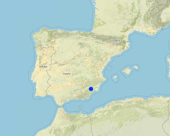
Location: Guadalentin catchment, Murcia, Spain

No. of Technology sites analysed:

Geo-reference of selected sites
  • -1.7076, 37.7931

Spread of the Technology: evenly spread over an area (approx. < 0.1 km2 (10 ha))

In a permanently protected area?:

Date of implementation: more than 50 years ago (traditional)

Type of introduction
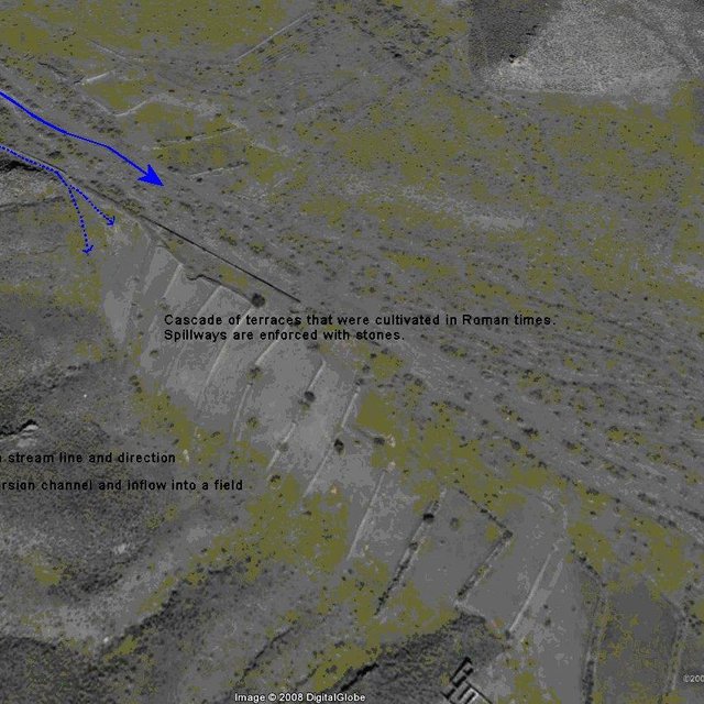
Aerial photograph of a water harvesting structure. A dyke in the lateral part of the stream diverts the water through a short channel towards a cascade of terraces that were cultivated during Roman times.
Aerial view of a traditional water harvesting system (boquera) in SE-Spain (Goggle Earth)

Classification of the Technology

Main purpose
  • improve production
  • reduce, prevent, restore land degradation
  • conserve ecosystem
  • protect a watershed/ downstream areas – in combination with other Technologies
  • preserve/ improve biodiversity
  • reduce risk of disasters
  • adapt to climate change/ extremes and its impacts
  • mitigate climate change and its impacts
  • create beneficial economic impact
  • create beneficial social impact
Land use
Land use mixed within the same land unit: Ja - Agroforestry

  • Cropland
    • Annual cropping: cereals - oats
    • Tree and shrub cropping
    Number of growing seasons per year: 1

Water supply
  • rainfed
  • mixed rainfed-irrigated
  • full irrigation

Purpose related to land degradation
  • prevent land degradation
  • reduce land degradation
  • restore/ rehabilitate severely degraded land
  • adapt to land degradation
  • not applicable
Degradation addressed
  • soil erosion by water - Wo: offsite degradation effects
  • water degradation - Ha: aridification
SLM group
  • water harvesting
SLM measures
  • structural measures - S1: Terraces, S4: Level ditches, pits, S11: Others

Technical drawing

Technical specifications
Sketch of a water harvesting structure consisting of an earthen- or stone- built dyke that diverts water into cultivated fields. Several terraces are present in the fields in order to reduce slope gradient and retain water longer within the fields to allow maximum infiltration. Depending on the expected inflow of water several spillways can be made per terrace to prevent excessive concentration of flow in each spillway.

Technical knowledge required for field staff / advisors: moderate (Selection of the proper location and assessment of up- and downstream linkages.)

Technical knowledge required for land users: low (Practical implementation of the water harvesting structure does not require a high level of knowledge)

Main technical functions: control of concentrated runoff: retain / trap, control of concentrated runoff: impede / retard, control of concentrated runoff: drain / divert, increase of infiltration, water harvesting / increase water supply

Secondary technical functions: increase of groundwater level / recharge of groundwater, water spreading

Spillway
Spacing between structures (m): 50
Depth of ditches/pits/dams (m): 0.5
Width of ditches/pits/dams (m): 1-3

Structural measure: water harvest dyke
Depth of ditches/pits/dams (m): <1
Width of ditches/pits/dams (m): <2
Length of ditches/pits/dams (m): <50

Construction material (earth): Soil from the stream banks is used to built the dyke and provide an opening into the cultivated fiel

Construction material (stone): Stones are used to fortify the dyke and spillways against the impact of flow.

Construction material (concrete): Potentially concrete is used to fortify the dyke and spillways against the impact of flow.

Specification of dams/ pans/ ponds: Capacity 5m3

Catchment area: >0.5km2m2

Beneficial area: 1-2 ham2

Slope of dam wall inside: 100%;
Slope of dam wall outside: 100%

Dimensions of spillways: 1-3m wide and <50 cm deep
Author: Joris de Vente

Establishment and maintenance: activities, inputs and costs

Calculation of inputs and costs
  • Costs are calculated:
  • Currency used for cost calculation: EURO
  • Exchange rate (to USD): 1 USD = 0.63 EURO
  • Average wage cost of hired labour per day: 79.00
Most important factors affecting the costs
Labour costs and price of concrete are the most determinate factors affecting the costs.
Establishment activities
  1. Construction of a dyke (dam) (Timing/ frequency: summer or winter)
Establishment inputs and costs
Specify input Unit Quantity Costs per Unit (EURO) Total costs per input (EURO) % of costs borne by land users
Labour
Labour 5 meter dyke 1.0 150.0 150.0 100.0
Equipment
Machine use 5 meter dyke 1.0 350.0 350.0 100.0
Construction material
Concrete 5 meter dyke 1.0 400.0 400.0 100.0
Total costs for establishment of the Technology 900.0
Total costs for establishment of the Technology in USD 1'428.57
Maintenance activities
  1. restoration of the dyke (Timing/ frequency: once in 5 yr (after important events))
Maintenance inputs and costs
Specify input Unit Quantity Costs per Unit (EURO) Total costs per input (EURO) % of costs borne by land users
Labour
Labour 5 meter dyke 1.0 4.0 4.0 100.0
Equipment
Machine use 5 meter dyke 1.0 12.0 12.0 100.0
Construction material
Concrete 5 meter dyke 1.0 25.0 25.0 100.0
Total costs for maintenance of the Technology 41.0
Total costs for maintenance of the Technology in USD 65.08

Natural environment

Average annual rainfall
  • < 250 mm
  • 251-500 mm
  • 501-750 mm
  • 751-1,000 mm
  • 1,001-1,500 mm
  • 1,501-2,000 mm
  • 2,001-3,000 mm
  • 3,001-4,000 mm
  • > 4,000 mm
Agro-climatic zone
  • humid
  • sub-humid
  • semi-arid
  • arid
Specifications on climate
Average annual rainfall in mm: 300.0
Thermal climate class: subtropics

Thermal climate class: temperate. The higher parts are generally somewhat colder
Slope
  • flat (0-2%)
  • gentle (3-5%)
  • moderate (6-10%)
  • rolling (11-15%)
  • hilly (16-30%)
  • steep (31-60%)
  • very steep (>60%)
Landforms
  • plateau/plains
  • ridges
  • mountain slopes
  • hill slopes
  • footslopes
  • valley floors
Altitude
  • 0-100 m a.s.l.
  • 101-500 m a.s.l.
  • 501-1,000 m a.s.l.
  • 1,001-1,500 m a.s.l.
  • 1,501-2,000 m a.s.l.
  • 2,001-2,500 m a.s.l.
  • 2,501-3,000 m a.s.l.
  • 3,001-4,000 m a.s.l.
  • > 4,000 m a.s.l.
Technology is applied in
  • convex situations
  • concave situations
  • not relevant
Soil depth
  • very shallow (0-20 cm)
  • shallow (21-50 cm)
  • moderately deep (51-80 cm)
  • deep (81-120 cm)
  • very deep (> 120 cm)
Soil texture (topsoil)
  • coarse/ light (sandy)
  • medium (loamy, silty)
  • fine/ heavy (clay)
Soil texture (> 20 cm below surface)
  • coarse/ light (sandy)
  • medium (loamy, silty)
  • fine/ heavy (clay)
Topsoil organic matter content
  • high (>3%)
  • medium (1-3%)
  • low (<1%)
Groundwater table
  • on surface
  • < 5 m
  • 5-50 m
  • > 50 m
Availability of surface water
  • excess
  • good
  • medium
  • poor/ none
Water quality (untreated)
  • good drinking water
  • poor drinking water (treatment required)
  • for agricultural use only (irrigation)
  • unusable
Water quality refers to:
Is salinity a problem?
  • Ja
  • Nee

Occurrence of flooding
  • Ja
  • Nee
Species diversity
  • high
  • medium
  • low
Habitat diversity
  • high
  • medium
  • low

Characteristics of land users applying the Technology

Market orientation
  • subsistence (self-supply)
  • mixed (subsistence/ commercial)
  • commercial/ market
Off-farm income
  • less than 10% of all income
  • 10-50% of all income
  • > 50% of all income
Relative level of wealth
  • very poor
  • poor
  • average
  • rich
  • very rich
Level of mechanization
  • manual work
  • animal traction
  • mechanized/ motorized
Sedentary or nomadic
  • Sedentary
  • Semi-nomadic
  • Nomadic
Individuals or groups
  • individual/ household
  • groups/ community
  • cooperative
  • employee (company, government)
Gender
  • women
  • men
Age
  • children
  • youth
  • middle-aged
  • elderly
Area used per household
  • < 0.5 ha
  • 0.5-1 ha
  • 1-2 ha
  • 2-5 ha
  • 5-15 ha
  • 15-50 ha
  • 50-100 ha
  • 100-500 ha
  • 500-1,000 ha
  • 1,000-10,000 ha
  • > 10,000 ha
Scale
  • small-scale
  • medium-scale
  • large-scale
Land ownership
  • state
  • company
  • communal/ village
  • group
  • individual, not titled
  • individual, titled
Land use rights
  • open access (unorganized)
  • communal (organized)
  • leased
  • individual
Water use rights
  • open access (unorganized)
  • communal (organized)
  • leased
  • individual
Access to services and infrastructure
health

poor
good
education

poor
good
technical assistance

poor
good
employment (e.g. off-farm)

poor
good
markets

poor
good
energy

poor
good
roads and transport

poor
good
drinking water and sanitation

poor
good
financial services

poor
good

Impacts

Socio-economic impacts
Crop production
decreased
increased


Depending on the amount of water harvested yield may be the same or increase slightly

risk of production failure
increased
decreased

irrigation water availability
decreased
increased

irrigation water quality
decreased
increased

expenses on agricultural inputs
increased
decreased


Implementation of dykes is considered relatively expensive

farm income
decreased
increased

Socio-cultural impacts
conflict mitigation
worsened
improved


Water extraction by a water harvesting may cause less water at downstream locations, whihc may cause conflicts

Improved livelihoods and human well-being
decreased
increased


during Roman and Arab times when most structures were operative they increased significantly the production. Nowadays, most of them are abandoned. However, those that are operational do cause increased crop yields.

Ecological impacts
water quantity
decreased
increased

harvesting/ collection of water (runoff, dew, snow, etc)
reduced
improved

surface runoff
increased
decreased

excess water drainage
reduced
improved


For small flood events only

groundwater table/ aquifer
lowered
recharge


Possibly a small effect

soil moisture
decreased
increased

Off-site impacts
reliable and stable stream flows in dry season (incl. low flows)
reduced
increased

downstream flooding (undesired)
increased
reduced


If various structures are present in a stream and only for relatively low intensity events

damage on public/ private infrastructure
increased
reduced

Cost-benefit analysis

Benefits compared with establishment costs
Short-term returns
very negative
very positive

Long-term returns
very negative
very positive

Benefits compared with maintenance costs
Short-term returns
very negative
very positive

Long-term returns
very negative
very positive

Implementation of the technology is relatively expensive. Once installed, maintenance is not expensive and pays off because of higher productivity.

Climate change

Gradual climate change
annual temperature increase

not well at all
very well
Climate-related extremes (disasters)
local rainstorm

not well at all
very well
local windstorm

not well at all
very well
drought

not well at all
very well
general (river) flood

not well at all
very well
Other climate-related consequences
reduced growing period

not well at all
very well

Adoption and adaptation

Percentage of land users in the area who have adopted the Technology
  • single cases/ experimental
  • 1-10%
  • 11-50%
  • > 50%
Of all those who have adopted the Technology, how many have done so without receiving material incentives?
  • 0-10%
  • 11-50%
  • 51-90%
  • 91-100%
Has the Technology been modified recently to adapt to changing conditions?
  • Ja
  • Nee
To which changing conditions?
  • climatic change/ extremes
  • changing markets
  • labour availability (e.g. due to migration)

Conclusions and lessons learnt

Strengths: land user's view
  • The extra input of free water allows higher crop productivity.
Strengths: compiler’s or other key resource person’s view
  • This technology is very effective at increasing water available for crop production and so increasing crop yield and farm income

    How can they be sustained / enhanced? Temporarily store the harvested water in a cistern to be used for irrigation using drip irrigation when most needed.
  • The technology takes advantage of floodwater that is otherwise lost because of the erratic character and short duration of flow

    How can they be sustained / enhanced? Finding the optimal location for the water harvesting structures using a modelling approach
Weaknesses/ disadvantages/ risks: land user's viewhow to overcome
  • Farmers consider it relatively expensive to implement and there is no guarantee for water as this depends on the rainfall events. Subsidies might help to install these structures where feasible. Therefore, good assessments of expected water inflow volumes are required before construction
Weaknesses/ disadvantages/ risks: compiler’s or other key resource person’s viewhow to overcome
  • The implementation costs are relatively high when the bunds are made of concrete Use of cheap materials that are freely available (stones from the fields). However, it is important to make the structure as resistant as possible against flood events.
  • The water provided by these techniques is mostly interesting for small- and medium- scale rainfed farming. Intensively irrigated farming requires more water and a guarantee for water independently of flood events Intensively irrigated farming might use this technology as an additional source of water and may store the harvested water in a cistern for use when needed.

References

Compiler
  • Joris De Vente
Editors
Reviewer
  • Deborah Niggli
  • Alexandra Gavilano
Date of documentation: Julie 1, 2011
Last update: Julie 23, 2019
Resource persons
Full description in the WOCAT database
Linked SLM data
Documentation was faciliated by
Institution Project
Key references
  • rot, E., van Wesemael, B., Benet, A.S. and House, M.A., 2008. Water harvesting potential in function of hillslope characteristics: A case study from the Sierra de Gador Journal of Arid Environments 72(7):1213-1231: Internet
  • Giráldez, J.V., Ayuso, J.L., Garcia, A., López, J.G. and Roldán, J., 1988. Water harvesting strategies in the semiarid climate of southeastern Spain. Agricultural Water Management, 14(1-4): 253-263.: Internet
  • Hooke, J.M. and Mant, J.M., 2002. Floodwater use and management strategies in valleys of southeast Spain. Land Degradation & Development, 13(2): 165-175.: Internet
  • López-Gálvez, J. and Losada, A., 1998. EVOLUCIÓN DE TÉCNICAS DE RIEGO EN EL SUDESTE DE ESPAÑA. Ingeniería del Agua, 5(3): 41-50.: Internet
  • Nasri, S., Albergel, J., Cudennec, C. and Berndtsson, R., 2004. Hydrological processes in macrocatchment water harvestingin the arid region of Tunisia: the traditional system of tabias. Hydrological Sciences-Journal, 49(2): 261-272.: Internet
  • van Wesemael, B., et al., 1998. Collection and storage of runoff from hillslopes in a semi-arid environment: geomorphic and hydrologic aspects of the aljibe system in Almeria (Spain). Journal of Arid Environments 40(1):1-14: Internet
  • Greenpeace, 2007. El negocio del agua en la cuenca del Segura, Greenpeace.: www.greenpeace.es
This work is licensed under Creative Commons Attribution-NonCommercial-ShareaAlike 4.0 International