Aserpiado in a vineyard (Wolfgang Duifhuizen)

Aserpiado (Spain)

Aserpiado or Alumbrado

Description

Aserpias are micro-depressions within a field along all or alternate inter vines rows, made by a tillage tool. The main objective of implementing Aserpiado is to let water infiltrate on-site, thereby increasing soil moisture and plant available water, decreasing runoff and associated losses of soil.

Aserpiado (also known as Alumbrado) is applied in vineyards in Southern Spain in lower and mid altitudes where the climate is characterized by relative high rainfall during winter, but almost none in summer. This requires adoptions in the water management like irrigation or on-site storage of water.
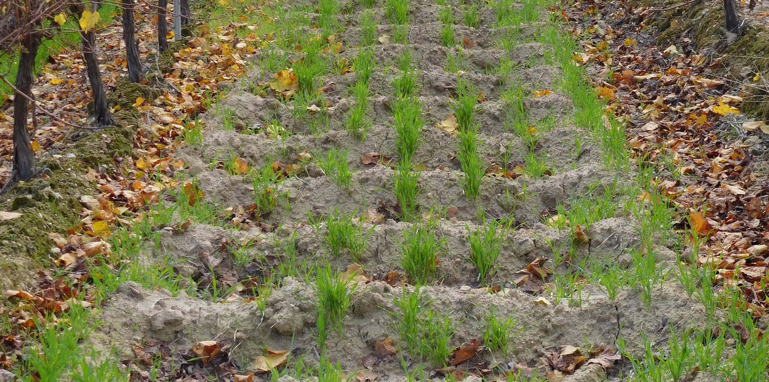
With the aserpiado technique, seasonal soil bunds are made every autumn in order to limit irrigation requirements and to protect the soil against erosion. These contour bunds in the allies remain in place the entire winter to make best use of precipitation that occurs mostly during this period.

The functioning of Aserpias was analysed in a vineyard within the Appellation of Origin Montilla-Moriles in Córdoba, the only previously existing documentation on this measure comes from vineyards in the Jerez wine region. Farmers use Aserpiado because it is the only way to get enough water without irrigation, as when irrigation is applied it cannot get the protected ‘Jerez-Sherry’ label.

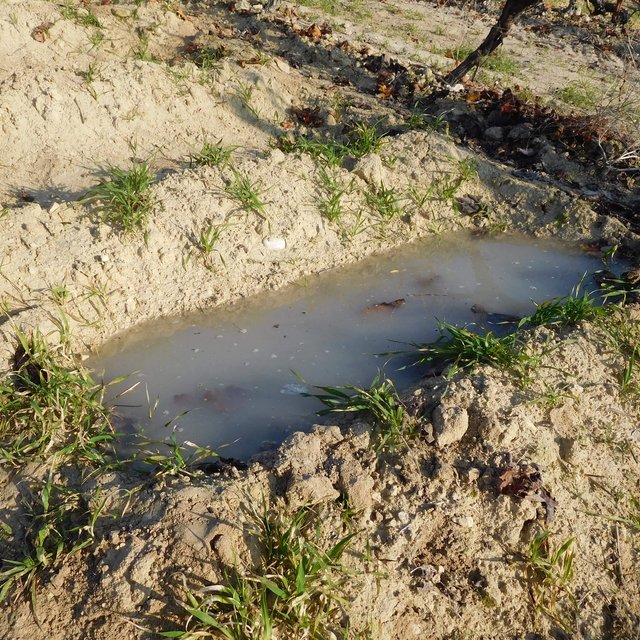
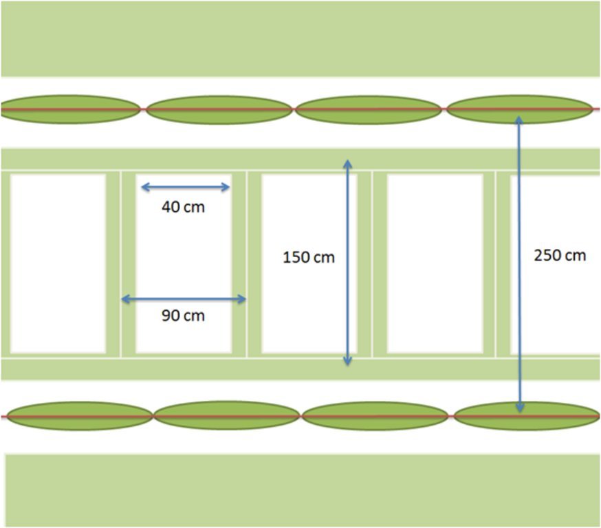
The microbasins are made in the inter-row area by dragging a caterpillar tractor pulled (see picture Aserpiadora) hydraulic beam over the field which lifts leaving a heap of soil behind. The speed and interval of the beam are set in such a way that a bund is made every 1.5 meter. Some users sow barely directly in advance of making the aserpiado which results in a high plant cover of the bunds during winter. The main function of Aserpiado is to catch rainwater which otherwise would be lost runoff. With Aserpiado the runoff is close to zero this means more water should become available for the crops.

The required inputs for creating and maintaining aserpias depends upon whether the bunds are permanent or seasonal. If permanent the ridges should be checked regulary and maintained by hand. When the aserpiado is only present during the winter season regular tillage in summer is necessary to keep the soil workable so the 'aserpiadora' (specialized tillage tool) can create the aserpias in autumn which are removed in spring to ease field traffic. With a modern-day Aserpiadora a farmer can create 3 to 5 ha of aserpias a day (Narvaez, 1980). The impacts of establishing aserpias are less soil erosion, less runoff and more water storage in the soil. Land users like Aserpiado as it is a very effective way to increase soil moisture and reduce soil erosion, when used in combination with cover crops the soil quality also improves over time.

Location

Location: Finca Cañada Navarro, Montilla, Andalucia, Cordoba Province, Spain

No. of Technology sites analysed: single site

Geo-reference of selected sites
  • -4.5573, 37.54113

Spread of the Technology: applied at specific points/ concentrated on a small area

In a permanently protected area?:

Date of implementation: less than 10 years ago (recently)

Type of introduction
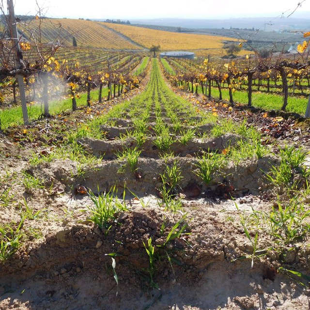
Aserpias; the soil bunds prevent runoff (Wolfgang Duifhuizen)
Some aserpias were filled with water for infiltration tests. (Gema Guzmán)

Classification of the Technology

Main purpose
  • improve production
  • reduce, prevent, restore land degradation
  • conserve ecosystem
  • protect a watershed/ downstream areas – in combination with other Technologies
  • preserve/ improve biodiversity
  • reduce risk of disasters
  • adapt to climate change/ extremes and its impacts
  • mitigate climate change and its impacts
  • create beneficial economic impact
  • create beneficial social impact
Land use

  • Cropland
    • Annual cropping: cereals - barley
    • Perennial (non-woody) cropping
    • Tree and shrub cropping: grapes
    Number of growing seasons per year: 1
Water supply
  • rainfed
  • mixed rainfed-irrigated
  • full irrigation

Purpose related to land degradation
  • prevent land degradation
  • reduce land degradation
  • restore/ rehabilitate severely degraded land
  • adapt to land degradation
  • not applicable
Degradation addressed
  • soil erosion by water - Wt: loss of topsoil/ surface erosion, Wg: gully erosion/ gullying
SLM group
  • improved ground/ vegetation cover
  • water harvesting
  • irrigation management (incl. water supply, drainage)
SLM measures
  • agronomic measures - A1: Vegetation/ soil cover, A3: Soil surface treatment
  • vegetative measures - V2: Grasses and perennial herbaceous plants

Technical drawing

Technical specifications
The bunds stretch over most of the inter-row alley, but in order not to expose superficial roots the bunds are 1.5 m wide so at each side there is about half a meter distance from the stems. Often the bunds are covered with barley and pruning residues. The bunds itself are 15 to 20 cm high and usually spaced 90 cm apart leaving 40 cm space at the base. At Cañada Navarro the Aserpia-bunds and sides are covered with barley as a cover crop during winter, in other sites where Aserpiado is applied the bunds remain bare.
Author: Wolfgang Duifhuizen

Establishment and maintenance: activities, inputs and costs

Calculation of inputs and costs
  • Costs are calculated: per Technology area (size and area unit: 22 hectares)
  • Currency used for cost calculation: Euros
  • Exchange rate (to USD): 1 USD = 0.94 Euros
  • Average wage cost of hired labour per day: n.a
Most important factors affecting the costs
The cost of Aserpiado and sown tasks compared to conventional farming.
Establishment activities
  1. (Timing/ frequency: None)
  2. (Timing/ frequency: None)
Maintenance activities
  1. Tillage with cultivator (15-20 cm deep) (Timing/ frequency: After harvest crop)
  2. Sowing barley in allies (Timing/ frequency: Autumn)
  3. Making aserpias in every other alley (Timing/ frequency: Soon after sowing barley)
  4. Killing cover crop (Timing/ frequency: Early in march)
  5. Tillage with cultivator (removing aserpias) (Timing/ frequency: After killing the cover crop)
Maintenance inputs and costs (per 22 hectares)
Specify input Unit Quantity Costs per Unit (Euros) Total costs per input (Euros) % of costs borne by land users
Labour
Tractor driver h/ha 5.5 40.0 220.0 96.0
Equipment
Scarifier h/ha 1.5 40.0 60.0 100.0
Seeder h/ha 2.25 40.0 90.0 100.0
Aserpiadora h/ha 1.5 40.0 60.0 100.0
Cultivator h/ha 1.5 40.0 60.0 100.0
Plant material
Barley seed kg/ha 80.0 0.2 16.0
Fertilizers and biocides
Herbicide** l/ha 3.0 6.67 20.01
Total costs for maintenance of the Technology 526.01
Total costs for maintenance of the Technology in USD 559.59

Natural environment

Average annual rainfall
  • < 250 mm
  • 251-500 mm
  • 501-750 mm
  • 751-1,000 mm
  • 1,001-1,500 mm
  • 1,501-2,000 mm
  • 2,001-3,000 mm
  • 3,001-4,000 mm
  • > 4,000 mm
Agro-climatic zone
  • humid
  • sub-humid
  • semi-arid
  • arid
Specifications on climate
Average annual rainfall in mm: 600.0
High annual variability and erratic rainfall patterns, historical precipitation records show an annual variation between 300 and 1200 mm.
Name of the meteorological station: Santaella IFAPA station
The Montilla region characterized by hot and dry summers, chilly winters and very few days of rainfall.
Slope
  • flat (0-2%)
  • gentle (3-5%)
  • moderate (6-10%)
  • rolling (11-15%)
  • hilly (16-30%)
  • steep (31-60%)
  • very steep (>60%)
Landforms
  • plateau/plains
  • ridges
  • mountain slopes
  • hill slopes
  • footslopes
  • valley floors
Altitude
  • 0-100 m a.s.l.
  • 101-500 m a.s.l.
  • 501-1,000 m a.s.l.
  • 1,001-1,500 m a.s.l.
  • 1,501-2,000 m a.s.l.
  • 2,001-2,500 m a.s.l.
  • 2,501-3,000 m a.s.l.
  • 3,001-4,000 m a.s.l.
  • > 4,000 m a.s.l.
Technology is applied in
  • convex situations
  • concave situations
  • not relevant
Soil depth
  • very shallow (0-20 cm)
  • shallow (21-50 cm)
  • moderately deep (51-80 cm)
  • deep (81-120 cm)
  • very deep (> 120 cm)
Soil texture (topsoil)
  • coarse/ light (sandy)
  • medium (loamy, silty)
  • fine/ heavy (clay)
Soil texture (> 20 cm below surface)
  • coarse/ light (sandy)
  • medium (loamy, silty)
  • fine/ heavy (clay)
Topsoil organic matter content
  • high (>3%)
  • medium (1-3%)
  • low (<1%)
Groundwater table
  • on surface
  • < 5 m
  • 5-50 m
  • > 50 m
Availability of surface water
  • excess
  • good
  • medium
  • poor/ none
Water quality (untreated)
  • good drinking water
  • poor drinking water (treatment required)
  • for agricultural use only (irrigation)
  • unusable
Water quality refers to:
Is salinity a problem?
  • Ja
  • Nee

Occurrence of flooding
  • Ja
  • Nee
Species diversity
  • high
  • medium
  • low
Habitat diversity
  • high
  • medium
  • low

Characteristics of land users applying the Technology

Market orientation
  • subsistence (self-supply)
  • mixed (subsistence/ commercial)
  • commercial/ market
Off-farm income
  • less than 10% of all income
  • 10-50% of all income
  • > 50% of all income
Relative level of wealth
  • very poor
  • poor
  • average
  • rich
  • very rich
Level of mechanization
  • manual work
  • animal traction
  • mechanized/ motorized
Sedentary or nomadic
  • Sedentary
  • Semi-nomadic
  • Nomadic
Individuals or groups
  • individual/ household
  • groups/ community
  • cooperative
  • employee (company, government)
Gender
  • women
  • men
Age
  • children
  • youth
  • middle-aged
  • elderly
Area used per household
  • < 0.5 ha
  • 0.5-1 ha
  • 1-2 ha
  • 2-5 ha
  • 5-15 ha
  • 15-50 ha
  • 50-100 ha
  • 100-500 ha
  • 500-1,000 ha
  • 1,000-10,000 ha
  • > 10,000 ha
Scale
  • small-scale
  • medium-scale
  • large-scale
Land ownership
  • state
  • company
  • communal/ village
  • group
  • individual, not titled
  • individual, titled
Land use rights
  • open access (unorganized)
  • communal (organized)
  • leased
  • individual
Water use rights
  • open access (unorganized)
  • communal (organized)
  • leased
  • individual
Access to services and infrastructure
health

poor
x
good
education

poor
x
good
technical assistance

poor
x
good
employment (e.g. off-farm)

poor
x
good
markets

poor
x
good
energy

poor
x
good
roads and transport

poor
x
good
drinking water and sanitation

poor
x
good
financial services

poor
x
good

Impacts

Socio-economic impacts
demand for irrigation water
increased
x
decreased

Socio-cultural impacts
Ecological impacts
harvesting/ collection of water (runoff, dew, snow, etc)
reduced
x
improved

surface runoff
increased
x
decreased

groundwater table/ aquifer
lowered
x
recharge


Water balance modelling on aserpiado fields indicate a high percolation rate

soil moisture
decreased
x
increased

soil loss
increased
x
decreased

Off-site impacts

Cost-benefit analysis

Benefits compared with establishment costs
Short-term returns
very negative
x
very positive

Long-term returns
very negative
x
very positive

Benefits compared with maintenance costs
Short-term returns
very negative
x
very positive

Long-term returns
very negative
x
very positive

Climate change

-

Adoption and adaptation

Percentage of land users in the area who have adopted the Technology
  • single cases/ experimental
  • 1-10%
  • 11-50%
  • > 50%
Of all those who have adopted the Technology, how many have done so without receiving material incentives?
  • 0-10%
  • 11-50%
  • 51-90%
  • 91-100%
Number of households and/ or area covered
120 ha (in Montilla-Moriles region)
Has the Technology been modified recently to adapt to changing conditions?
  • Ja
  • Nee
To which changing conditions?
  • climatic change/ extremes
  • changing markets
  • labour availability (e.g. due to migration)

Conclusions and lessons learnt

Strengths: land user's view
  • 1. Storage of water from winter rainfalls.
    2. Control of soil erosion.
    3. Benefits associated to the cover crops.
Strengths: compiler’s or other key resource person’s view
  • Control of erosion
    Increasing infiltration
Weaknesses/ disadvantages/ risks: land user's viewhow to overcome
  • No significant disadvantages or higher cost have been noticed compared to a cover crop farm.
Weaknesses/ disadvantages/ risks: compiler’s or other key resource person’s viewhow to overcome
  • If the aserpiado fails, concentration of runoff in rills will easily occur. To make aserpiado large enough to not be overtopped by regular rainstorms, also bunds need to be checked for stability.

References

Compiler
  • Wolfgang Duifhuizen
Editors
  • Gema Guzmán
Reviewer
  • Ursula Gaemperli
  • Alexandra Gavilano
Date of documentation: Des. 5, 2016
Last update: Aug. 1, 2019
Resource persons
Full description in the WOCAT database
Linked SLM data
Documentation was faciliated by
Institution Project
Links to relevant information which is available online
This work is licensed under Creative Commons Attribution-NonCommercial-ShareaAlike 4.0 International