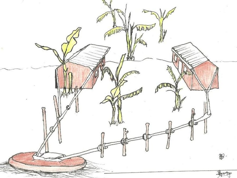
The water harvesting system with 3 components: the corrugated iron roof, the gutters and the storage tank (Charles L Malingu (Kagera TAMP, Kabale))

Rubagano rooftop rainwater harvesting system (with concrete/brick tank) (Uganda)

Okwombeka tanka z'amaizi ahamaju (Runyankore)

Description

Rain-water from all corrugated iron roof structures in one compound is harvested and stored in underground tanks.

Despite high precipitation (>1200 mm), Rubagano still experiences water shortage. It is hilly, with steep (>30%) to very steep (>58%) slopes. Rain water runs off to the valleys below, causing erosion and damaging infrastructure such as roads along its course. There is little rain water infiltration and the ground water level low. The few boreholes that government constructed in the area are often dry. Therefore women and children normally walk distances of up to 4 km to fetch water which, in many cases, is actually runoff dammed behind a concrete wall built across an open rock patch. To alleviate water scarcity, farmers have been mobilized by Kagera TAMP project to harvest the rain water from their own roofs. Because water sources are far from most households, rooftop water harvesting has a very high utility for the farmers. Adoption is high.

Purpose of the Technology: The primary goal of the technology is to increase household water availability. It also reduces runoff, produces water for the tree nursery and backyard gardens..

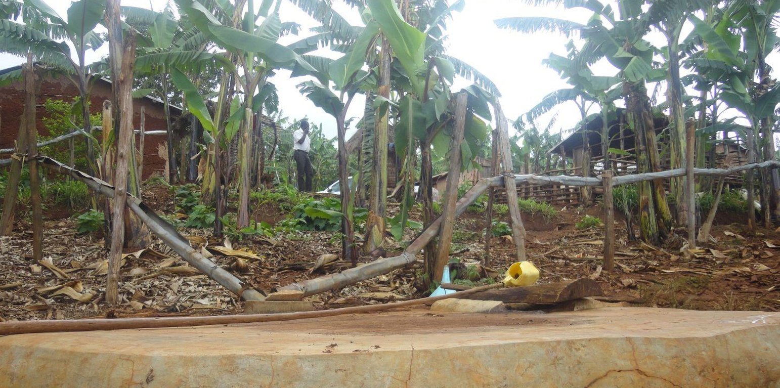
Establishment / maintenance activities and inputs: Requirements for harvesting water on an iron roof are water collection gutters and an underground tank. Rain falling on the roof flows into collection gutters constructed around the roof which angle gently away from the house and end at one or more underground tanks. Excavation and construction of the storage tank is costly and requires well qualified artisans. These are trained locally and are available within the community to minimize costs. The underground tank is constructed by excavating the ground between 3.0 m and 3.5 m deep and 2.0 m to 2.5 m diameter. Thus, a small tank will have a capacity of 38,000 litres (38 cubic metres). The bottom and walls of the pit is then built up throughout with brick and mortar. The top is a concrete slab with 2 openings of 0.3 m diameter, one connected to the gutters and the other through which a plastic container is lowered to fetch water. Though establishment costs appear high for farmers, the longer term benefits outweigh the original cost. Once established the maintenance costs are limited to periodic cleaning.

Natural / human environment: Heavy rainstorms may blow the gutters out of position.

Location

Location: Mbarara District (Rubagano, Mwizi), Uganda, Uganda

No. of Technology sites analysed:

Geo-reference of selected sites
  • 30.62128, -0.85527

Spread of the Technology:

In a permanently protected area?:

Date of implementation: less than 10 years ago (recently)

Type of introduction
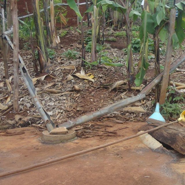
Th storage tank capacity determines how long, during a dry spell, the farm household will stay water secure. A typical tank is 3m to 4m deep and 2.5m to 3.0m in diameter (Charles L Mlingu (Kagera TAMP, Kabale))

Classification of the Technology

Main purpose
  • improve production
  • reduce, prevent, restore land degradation
  • conserve ecosystem
  • protect a watershed/ downstream areas – in combination with other Technologies
  • preserve/ improve biodiversity
  • reduce risk of disasters
  • adapt to climate change/ extremes and its impacts
  • mitigate climate change and its impacts
  • create beneficial economic impact
  • create beneficial social impact
Land use

  • Cropland
    • Perennial (non-woody) cropping: banana/plantain/abaca
    • Tree and shrub cropping: coffee, open grown
  • Waterways, waterbodies, wetlands -
Water supply
  • rainfed
  • mixed rainfed-irrigated
  • full irrigation

Purpose related to land degradation
  • prevent land degradation
  • reduce land degradation
  • restore/ rehabilitate severely degraded land
  • adapt to land degradation
  • not applicable
Degradation addressed
  • water degradation - Hs: change in quantity of surface water, Hp: decline of surface water quality
SLM group
  • water harvesting
SLM measures
  • structural measures - S5: Dams, pans, ponds

Technical drawing

Technical specifications
Details of rainwater harvesting system: roof catchment, gutters and underground storage tank

Location: Rubagano, Mwizi Sub-county, Mbarara District. Uganda

Date: 18 December 2013

Technical knowledge required for field staff / advisors: moderate

Technical knowledge required for land users: low (Artisan's work once the land user has decided on the size of the water tank required)

Main technical functions: water harvesting / increase water supply

Secondary technical functions: control of dispersed runoff: retain / trap, control of concentrated runoff: drain / divert, water spreading

Dam/ pan/ pond
Depth of ditches/pits/dams (m): d=3.0
Width of ditches/pits/dams (m): r=2.0
Length of ditches/pits/dams (m): n/a

Specification of dams/ pans/ ponds: Capacity 38m3

Catchment area: 900 m2m2

Beneficial area: 900 m2m2

For water harvesting: the ratio between the area where the harvested water is applied and the total area from which water is collected is: 1:0.1
Author: Byonabye Proscovia, Kabale, Uganda

Establishment and maintenance: activities, inputs and costs

Calculation of inputs and costs
  • Costs are calculated:
  • Currency used for cost calculation: UGX
  • Exchange rate (to USD): 1 USD = 2500.0 UGX
  • Average wage cost of hired labour per day: 10.00
Most important factors affecting the costs
Skilled labor for the construction of the underground tank
Establishment activities
  1. Tank construction (Timing/ frequency: Throughout the year)
  2. Procurement and raising of collection gutters (Timing/ frequency: Throughout the year)
  3. Wooden poles (Timing/ frequency: Throughout the year)
Establishment inputs and costs
Specify input Unit Quantity Costs per Unit (UGX) Total costs per input (UGX) % of costs borne by land users
Labour
Labour ha 1.0 500.0 500.0 100.0
Equipment
Tools ha 1.0 30.0 30.0 100.0
Construction material
Wood ha 1.0 16.0 16.0 100.0
Bricks ha 1.0 400.0 400.0 100.0
Cement ha 1.0 420.0 420.0 100.0
Sand ha 1.0 160.0 160.0 100.0
Total costs for establishment of the Technology 1'526.0
Total costs for establishment of the Technology in USD 0.61
Maintenance activities
  1. Tank maintenance (above ground) (Timing/ frequency: Once a year)
  2. Gutter replacement (Timing/ frequency: Twice a year)
  3. Wooden poles (Timing/ frequency: Twice a year)
Maintenance inputs and costs
Specify input Unit Quantity Costs per Unit (UGX) Total costs per input (UGX) % of costs borne by land users
Labour
Labour ha 1.0 80.0 80.0 100.0
Equipment
Tools ha 1.0 10.0 10.0 100.0
Construction material
Wood ha 1.0 4.0 4.0 100.0
Bricks ha 1.0 40.0 40.0 100.0
Cement ha 1.0 42.0 42.0 100.0
Sand ha 1.0 40.0 40.0 100.0
Total costs for maintenance of the Technology 216.0
Total costs for maintenance of the Technology in USD 0.09

Natural environment

Average annual rainfall
  • < 250 mm
  • 251-500 mm
  • 501-750 mm
  • 751-1,000 mm
  • 1,001-1,500 mm
  • 1,501-2,000 mm
  • 2,001-3,000 mm
  • 3,001-4,000 mm
  • > 4,000 mm
Agro-climatic zone
  • humid
  • sub-humid
  • semi-arid
  • arid
Specifications on climate
Average annual rainfall for Rubagano is >1200 mm
Thermal climate class: tropics
Slope
  • flat (0-2%)
  • gentle (3-5%)
  • moderate (6-10%)
  • rolling (11-15%)
  • hilly (16-30%)
  • steep (31-60%)
  • very steep (>60%)
Landforms
  • plateau/plains
  • ridges
  • mountain slopes
  • hill slopes
  • footslopes
  • valley floors
Altitude
  • 0-100 m a.s.l.
  • 101-500 m a.s.l.
  • 501-1,000 m a.s.l.
  • 1,001-1,500 m a.s.l.
  • 1,501-2,000 m a.s.l.
  • 2,001-2,500 m a.s.l.
  • 2,501-3,000 m a.s.l.
  • 3,001-4,000 m a.s.l.
  • > 4,000 m a.s.l.
Technology is applied in
  • convex situations
  • concave situations
  • not relevant
Soil depth
  • very shallow (0-20 cm)
  • shallow (21-50 cm)
  • moderately deep (51-80 cm)
  • deep (81-120 cm)
  • very deep (> 120 cm)
Soil texture (topsoil)
  • coarse/ light (sandy)
  • medium (loamy, silty)
  • fine/ heavy (clay)
Soil texture (> 20 cm below surface)
  • coarse/ light (sandy)
  • medium (loamy, silty)
  • fine/ heavy (clay)
Topsoil organic matter content
  • high (>3%)
  • medium (1-3%)
  • low (<1%)
Groundwater table
  • on surface
  • < 5 m
  • 5-50 m
  • > 50 m
Availability of surface water
  • excess
  • good
  • medium
  • poor/ none
Water quality (untreated)
  • good drinking water
  • poor drinking water (treatment required)
  • for agricultural use only (irrigation)
  • unusable
Water quality refers to:
Is salinity a problem?
  • Ja
  • Nee

Occurrence of flooding
  • Ja
  • Nee
Species diversity
  • high
  • medium
  • low
Habitat diversity
  • high
  • medium
  • low

Characteristics of land users applying the Technology

Market orientation
  • subsistence (self-supply)
  • mixed (subsistence/ commercial)
  • commercial/ market
Off-farm income
  • less than 10% of all income
  • 10-50% of all income
  • > 50% of all income
Relative level of wealth
  • very poor
  • poor
  • average
  • rich
  • very rich
Level of mechanization
  • manual work
  • animal traction
  • mechanized/ motorized
Sedentary or nomadic
  • Sedentary
  • Semi-nomadic
  • Nomadic
Individuals or groups
  • individual/ household
  • groups/ community
  • cooperative
  • employee (company, government)
Gender
  • women
  • men
Age
  • children
  • youth
  • middle-aged
  • elderly
Area used per household
  • < 0.5 ha
  • 0.5-1 ha
  • 1-2 ha
  • 2-5 ha
  • 5-15 ha
  • 15-50 ha
  • 50-100 ha
  • 100-500 ha
  • 500-1,000 ha
  • 1,000-10,000 ha
  • > 10,000 ha
Scale
  • small-scale
  • medium-scale
  • large-scale
Land ownership
  • state
  • company
  • communal/ village
  • group
  • individual, not titled
  • individual, titled
Land use rights
  • open access (unorganized)
  • communal (organized)
  • leased
  • individual
Water use rights
  • open access (unorganized)
  • communal (organized)
  • leased
  • individual
Access to services and infrastructure
health

poor
x
good
education

poor
x
good
technical assistance

poor
x
good
employment (e.g. off-farm)

poor
x
good
markets

poor
x
good
energy

poor
x
good
roads and transport

poor
x
good
drinking water and sanitation

poor
x
good
financial services

poor
x
good

Impacts

Socio-economic impacts
Crop production
decreased
x
increased

wood production
decreased
x
increased

risk of production failure
increased
x
decreased

production area (new land under cultivation/ use)
decreased
x
increased

drinking water availability
decreased
x
increased

expenses on agricultural inputs
increased
x
decreased

farm income
decreased
x
increased

Socio-cultural impacts
food security/ self-sufficiency
reduced
x
improved

health situation
worsened
x
improved

SLM/ land degradation knowledge
reduced
x
improved

situation of socially and economically disadvantaged groups (gender, age, status, ehtnicity etc.)
worsened
x
improved


Women and children

Improved livelihoods and human well-being
decreased
x
increased


Women and children no longer have to walk long distances in search of water.

Ecological impacts
water quantity
decreased
x
increased

water quality
decreased
x
increased

harvesting/ collection of water (runoff, dew, snow, etc)
reduced
x
improved

surface runoff
increased
x
decreased

evaporation
increased
x
decreased

soil moisture
decreased
x
increased

plant diversity
decreased
x
increased

Off-site impacts
water availability (groundwater, springs)
decreased
x
increased

downstream flooding (undesired)
increased
x
reduced

damage on public/ private infrastructure
increased
x
reduced


E.g. Roads

Cost-benefit analysis

Benefits compared with establishment costs
Short-term returns
very negative
x
very positive

Long-term returns
very negative
x
very positive

Benefits compared with maintenance costs
Short-term returns
very negative
x
very positive

Long-term returns
very negative
x
very positive

The technology may appear expensive to the farmer at the time of establishment but it is cost-effective in the long-term.

Climate change

Gradual climate change
annual temperature increase

not well at all
x
very well
Climate-related extremes (disasters)
local rainstorm

not well at all
x
very well
local windstorm

not well at all
x
very well
drought

not well at all
x
very well
general (river) flood

not well at all
x
very well
Other climate-related consequences
reduced growing period

not well at all
x
very well

Adoption and adaptation

Percentage of land users in the area who have adopted the Technology
  • single cases/ experimental
  • 1-10%
  • 11-50%
  • > 50%
Of all those who have adopted the Technology, how many have done so without receiving material incentives?
  • 0-10%
  • 11-50%
  • 51-90%
  • 91-100%
Number of households and/ or area covered
25
Has the Technology been modified recently to adapt to changing conditions?
  • Ja
  • Nee
To which changing conditions?
  • climatic change/ extremes
  • changing markets
  • labour availability (e.g. due to migration)

Conclusions and lessons learnt

Strengths: land user's view
Strengths: compiler’s or other key resource person’s view
  • Makes water for drinking and domestic use more readily available to the household

    How can they be sustained / enhanced? Encourage adoption and maintenance through farmer-to-farmer information
  • Saves women and children from walking long distances in search of clean water

    How can they be sustained / enhanced? Empower women and children to demand and obtain rooftop water harvesting at home
  • Rooftop harvested water is cleaner than trapped runoff used by many members of the community

    How can they be sustained / enhanced? Help households to acquire materials for rooftop water harvesting
Weaknesses/ disadvantages/ risks: land user's viewhow to overcome
Weaknesses/ disadvantages/ risks: compiler’s or other key resource person’s viewhow to overcome
  • Technology is expensive to establish Support government and private sector to subsidize tanking systems for farmers
  • Requires technical expertise especially in concrete preparation to prevent cracks and leakages Ensure farmers who express the need to adapt get access to construction technicians

References

Compiler
  • Wilson Bamwerinde
Editors
Reviewer
  • Fabian Ottiger
  • Alexandra Gavilano
Date of documentation: Des. 9, 2013
Last update: Aug. 11, 2019
Resource persons
Full description in the WOCAT database
Linked SLM data
Documentation was faciliated by
Institution Project
Key references
  • Kagera TAMP project website: www.fao.org/nr/kagera/en
This work is licensed under Creative Commons Attribution-NonCommercial-ShareaAlike 4.0 International