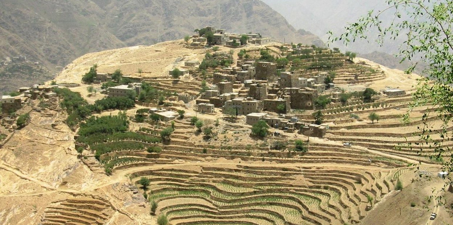
Agricultural contour terraces next to the upper catchment area

Flat Contour Terraces (Yemen)

المدرجات الكنتورية

Description

Old flat terraces were built in accordance with the contour lines and surrounded by stones to create a suitable environment for the growth of crops, slope stabilization and reduce the risk of runoff and increasing water harvesting.

The Yemeni farmer challenged the nature cruel and adopted to cope with the needs and requirements, including the construction of agricultural terraces utilizing all the resources available in the region, where he worked first on the extraction of soil located on the slopes of the mountains and booked by building a wall of stones around where were collected and brought stones from different places. Walls were built in very geometric creativity very well designed so that they work to minimize the risk of soil erosion and increase the use of water runoff without damages to the established terraces so through the construction of terraces along contour lines and making outlets in each terrace to drain excess water.

The process of building terraces using stones according to the contours, which works to prevent soil erosion and erosion, as well as help to increase soil moisture as a result harvest runoff, which leads to meet the needs of crop water and thereby increase production.

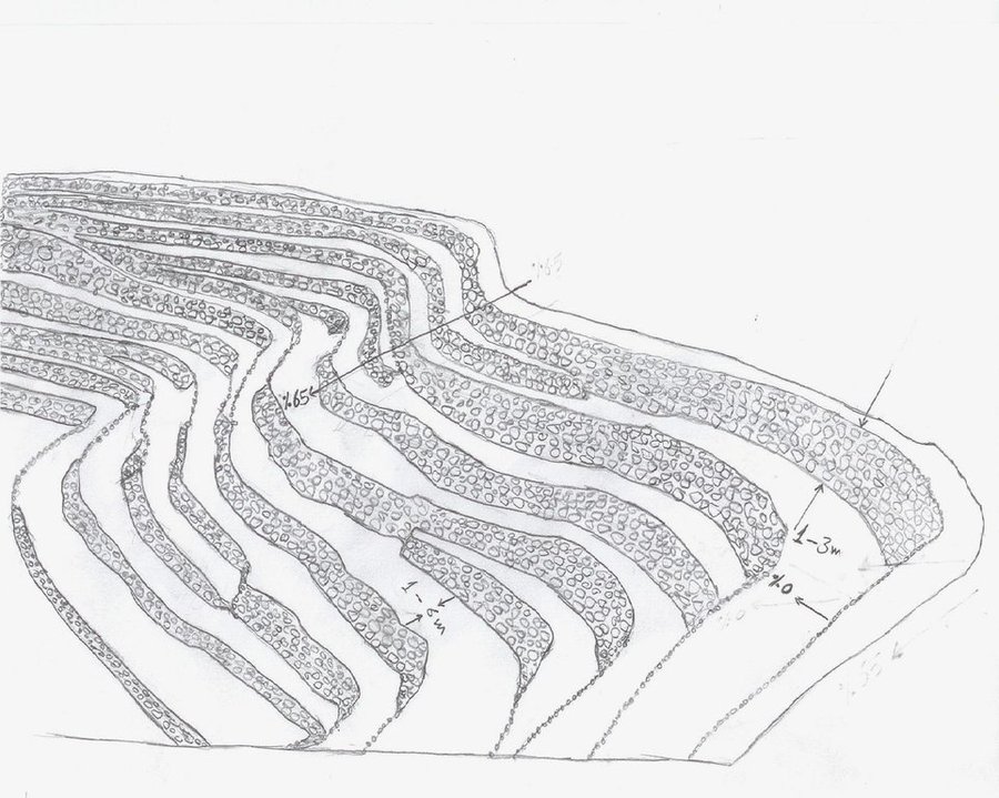
The main objective of building terraces is to increase production. The soil depth at the beginning of the establishment of the stands to be very shallow and increasing soil depth as a result of increasing deposits the soil.This process is booked by increasing the height of the wall that range between 1-3 meters, and a width runway between 1-6 meters As for the length of the runway It is 5 - 80 meters according to the contour line, which runs on reserve deposits and protect the soil from erosion.. Finally terraces are planted with annual crops mainly cereals crops, as well as perennial trees such as coffee, diamond, Qat and other perennial trees.

The terraces of the projects long-term where you need a long time to build due to the use of hands in the construction process as a result you cannot use the mechanisms, for maintenance operations in view of the building stands on the regions of steep and where the rate of runoff high result of heavy rains in a short time in addition to Regression factor that leads to increase the speed of the flow of water, which operate on a cliff erosion terraces in the event of lack of maintenance, which makes the process of ongoing maintenance is an urgent need to ensure the preservation and sustainability of the stands.

Location

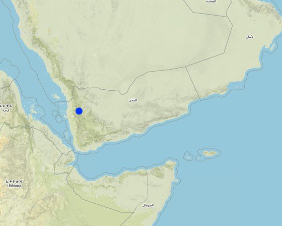
Location: Kahlan Afar, Hajah Governorate, Yemen

No. of Technology sites analysed:

Geo-reference of selected sites
  • 43.70736, 15.70772

Spread of the Technology: evenly spread over an area

In a permanently protected area?:

Date of implementation: more than 50 years ago (traditional)

Type of introduction
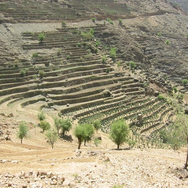
Agricultural terraces in the middle of the catchment area

Classification of the Technology

Main purpose
  • improve production
  • reduce, prevent, restore land degradation
  • conserve ecosystem
  • protect a watershed/ downstream areas – in combination with other Technologies
  • preserve/ improve biodiversity
  • reduce risk of disasters
  • adapt to climate change/ extremes and its impacts
  • mitigate climate change and its impacts
  • create beneficial economic impact
  • create beneficial social impact
Land use

  • Cropland
    • Annual cropping: cereals - barley, cereals - maize, cereals - other, cereals - wheat (spring), legumes and pulses - beans, lentils
    • Tree and shrub cropping: coffee, open grown, Qat, Diamond
    Number of growing seasons per year: 2
Water supply
  • rainfed
  • mixed rainfed-irrigated
  • full irrigation

Purpose related to land degradation
  • prevent land degradation
  • reduce land degradation
  • restore/ rehabilitate severely degraded land
  • adapt to land degradation
  • not applicable
Degradation addressed
  • soil erosion by water - Wt: loss of topsoil/ surface erosion, Wg: gully erosion/ gullying
  • biological degradation - Bc: reduction of vegetation cover
  • water degradation - Ha: aridification
SLM group
  • cross-slope measure
SLM measures
  • agronomic measures - A3: Soil surface treatment
  • structural measures - S1: Terraces

Technical drawing

Technical specifications
terraces built along contour lines

Location: Hajah Governorate. Kahlan Afer

Date: 10-2-2013

Technical knowledge required for field staff / advisors: moderate (does not have only a little experience)

Technical knowledge required for land users: low (Has enough experience)

Main technical functions: reduction of slope angle, reduction of slope length, water harvesting / increase water supply, sediment retention / trapping, sediment harvesting, reduction surface runoff

Secondary technical functions: increase of infiltration, water spreading

Contour tillage
Material/ species: agricultural tools, animal traction

Terrace: bench level
Vertical interval between structures (m): 1 - 3
Spacing between structures (m): 1 - 6
Height of bunds/banks/others (m): 1 - 3
Width of bunds/banks/others (m): 1 - 6
Length of bunds/banks/others (m): 5 - 80

Construction material (earth): Collecting soil and reserve deposits to increase the soil depth

Construction material (stone): Stones available in the region

Slope (which determines the spacing indicated above): 65%

If the original slope has changed as a result of the Technology, the slope today is: 0%

Lateral gradient along the structure: 0%

For water harvesting: the ratio between the area where the harvested water is applied and the total area from which water is collected is: 1:1
Author: Algalal

Establishment and maintenance: activities, inputs and costs

Calculation of inputs and costs
  • Costs are calculated:
  • Currency used for cost calculation: USD
  • Exchange rate (to USD): 1 USD = n.a
  • Average wage cost of hired labour per day: 7.00
Most important factors affecting the costs
Collecting and transporting stones Severe slopes
Establishment activities
  1. Extraction of soil (Timing/ frequency: Before the rainy season)
  2. Collecting stones (Timing/ frequency: Before the rainy season)
  3. Build a wall to establish a terrace (Timing/ frequency: Before the rainy season)
Establishment inputs and costs
Specify input Unit Quantity Costs per Unit (USD) Total costs per input (USD) % of costs borne by land users
Labour
Extraction of soil ha 1.0 2500.0 2500.0 100.0
Collecting stones ha 1.0 1162.8 1162.8 100.0
Build a wall to establish a terrace ha 1.0 558.0 558.0 100.0
Equipment
Tools ha 1.0 46.5 46.5 100.0
Animal traction ha 1.0 186.0 186.0 100.0
Total costs for establishment of the Technology 4'453.3
Total costs for establishment of the Technology in USD 4'453.3
Maintenance activities
  1. plowing along contour lines (Timing/ frequency: Before planting)
  2. Repairing damaged walls (Timing/ frequency: annually after the rain)
Maintenance inputs and costs
Specify input Unit Quantity Costs per Unit (USD) Total costs per input (USD) % of costs borne by land users
Labour
Plowing along contour lines ha 1.0 50.0 50.0 100.0
Repairing damaged walls ha 1.0 100.0 100.0 100.0
Equipment
Tools ha 1.0 30.0 30.0 100.0
Animal traction ha 1.0 50.0 50.0 100.0
Tools ha 1.0 18.6 18.6 100.0
Total costs for maintenance of the Technology 248.6
Total costs for maintenance of the Technology in USD 248.6

Natural environment

Average annual rainfall
  • < 250 mm
  • 251-500 mm
  • 501-750 mm
  • 751-1,000 mm
  • 1,001-1,500 mm
  • 1,501-2,000 mm
  • 2,001-3,000 mm
  • 3,001-4,000 mm
  • > 4,000 mm
Agro-climatic zone
  • humid
  • sub-humid
  • semi-arid
  • arid
Specifications on climate
Thermal climate class: temperate
Slope
  • flat (0-2%)
  • gentle (3-5%)
  • moderate (6-10%)
  • rolling (11-15%)
  • hilly (16-30%)
  • steep (31-60%)
  • very steep (>60%)
Landforms
  • plateau/plains
  • ridges
  • mountain slopes
  • hill slopes
  • footslopes
  • valley floors
Altitude
  • 0-100 m a.s.l.
  • 101-500 m a.s.l.
  • 501-1,000 m a.s.l.
  • 1,001-1,500 m a.s.l.
  • 1,501-2,000 m a.s.l.
  • 2,001-2,500 m a.s.l.
  • 2,501-3,000 m a.s.l.
  • 3,001-4,000 m a.s.l.
  • > 4,000 m a.s.l.
Technology is applied in
  • convex situations
  • concave situations
  • not relevant
Soil depth
  • very shallow (0-20 cm)
  • shallow (21-50 cm)
  • moderately deep (51-80 cm)
  • deep (81-120 cm)
  • very deep (> 120 cm)
Soil texture (topsoil)
  • coarse/ light (sandy)
  • medium (loamy, silty)
  • fine/ heavy (clay)
Soil texture (> 20 cm below surface)
  • coarse/ light (sandy)
  • medium (loamy, silty)
  • fine/ heavy (clay)
Topsoil organic matter content
  • high (>3%)
  • medium (1-3%)
  • low (<1%)
Groundwater table
  • on surface
  • < 5 m
  • 5-50 m
  • > 50 m
Availability of surface water
  • excess
  • good
  • medium
  • poor/ none
Water quality (untreated)
  • good drinking water
  • poor drinking water (treatment required)
  • for agricultural use only (irrigation)
  • unusable
Water quality refers to:
Is salinity a problem?
  • Ja
  • Nee

Occurrence of flooding
  • Ja
  • Nee
Species diversity
  • high
  • medium
  • low
Habitat diversity
  • high
  • medium
  • low

Characteristics of land users applying the Technology

Market orientation
  • subsistence (self-supply)
  • mixed (subsistence/ commercial)
  • commercial/ market
Off-farm income
  • less than 10% of all income
  • 10-50% of all income
  • > 50% of all income
Relative level of wealth
  • very poor
  • poor
  • average
  • rich
  • very rich
Level of mechanization
  • manual work
  • animal traction
  • mechanized/ motorized
Sedentary or nomadic
  • Sedentary
  • Semi-nomadic
  • Nomadic
Individuals or groups
  • individual/ household
  • groups/ community
  • cooperative
  • employee (company, government)
Gender
  • women
  • men
Age
  • children
  • youth
  • middle-aged
  • elderly
Area used per household
  • < 0.5 ha
  • 0.5-1 ha
  • 1-2 ha
  • 2-5 ha
  • 5-15 ha
  • 15-50 ha
  • 50-100 ha
  • 100-500 ha
  • 500-1,000 ha
  • 1,000-10,000 ha
  • > 10,000 ha
Scale
  • small-scale
  • medium-scale
  • large-scale
Land ownership
  • state
  • company
  • communal/ village
  • group
  • individual, not titled
  • individual, titled
Land use rights
  • open access (unorganized)
  • communal (organized)
  • leased
  • individual
  • Waqf
Water use rights
  • open access (unorganized)
  • communal (organized)
  • leased
  • individual
  • Waqf
Access to services and infrastructure
health

poor
x
good
education

poor
x
good
technical assistance

poor
x
good
employment (e.g. off-farm)

poor
x
good
markets

poor
x
good
energy

poor
x
good
roads and transport

poor
x
good
drinking water and sanitation

poor
x
good
financial services

poor
x
good

Impacts

Socio-economic impacts
Crop production
decreased
x
increased

fodder production
decreased
x
increased

risk of production failure
increased
x
decreased

production area (new land under cultivation/ use)
decreased
x
increased

land management
hindered
x
simplified

drinking water availability
decreased
x
increased


As a result of the infiltration process

farm income
decreased
x
increased

workload
increased
x
decreased

Socio-cultural impacts
food security/ self-sufficiency
reduced
x
improved

cultural opportunities (eg spiritual, aesthetic, others)
reduced
x
improved

SLM/ land degradation knowledge
reduced
x
improved

livelihood and human well-being
reduced
x
improved

Ecological impacts
water quantity
decreased
x
increased

harvesting/ collection of water (runoff, dew, snow, etc)
reduced
x
improved

surface runoff
increased
x
decreased

excess water drainage
reduced
x
improved

groundwater table/ aquifer
lowered
x
recharge

soil moisture
decreased
x
increased

soil loss
increased
x
decreased

plant diversity
decreased
x
increased

habitat diversity
decreased
x
increased

Off-site impacts
water availability (groundwater, springs)
decreased
x
increased

downstream flooding (undesired)
increased
x
reduced

downstream siltation
increased
x
decreased


reduction of sediments

Cost-benefit analysis

Benefits compared with establishment costs
Short-term returns
very negative
x
very positive

Long-term returns
very negative
x
very positive

Benefits compared with maintenance costs
Short-term returns
very negative
x
very positive

Long-term returns
very negative
x
very positive

Climate change

Gradual climate change
annual temperature increase

not well at all
x
very well
Climate-related extremes (disasters)
local rainstorm

not well at all
x
very well

Adoption and adaptation

Percentage of land users in the area who have adopted the Technology
  • single cases/ experimental
  • 1-10%
  • 11-50%
  • > 50%
Of all those who have adopted the Technology, how many have done so without receiving material incentives?
  • 0-10%
  • 11-50%
  • 51-90%
  • 91-100%
Number of households and/ or area covered
994 households covering 100 percent of stated area
Has the Technology been modified recently to adapt to changing conditions?
  • Ja
  • Nee
To which changing conditions?
  • climatic change/ extremes
  • changing markets
  • labour availability (e.g. due to migration)

Conclusions and lessons learnt

Strengths: land user's view
Strengths: compiler’s or other key resource person’s view
  • Creating a suitable environment for the growth of various crops

    How can they be sustained / enhanced? continue the process of maintenance to maintain walls and outlets
  • Water harvesting to increase soil moisture

    How can they be sustained / enhanced? maintenance of water outlet constantly ensure that no water erosion by allowing excess water to drain out through the outlets.
  • reduce runoff and Prevention of soil erosion

    How can they be sustained / enhanced? ongoing maintenance of outlets.
  • discharge excess water in a systematic manner

    How can they be sustained / enhanced? ongoing maintenance of water exits
  • reduce the length and angle of the slope

    How can they be sustained / enhanced? Maintaining the terraces
Weaknesses/ disadvantages/ risks: land user's viewhow to overcome
Weaknesses/ disadvantages/ risks: compiler’s or other key resource person’s viewhow to overcome
  • Low productivity in the first years of the Created stands terraces due to poor soil fertility and lack of depth apply fertilizer and chemical and organic fertilizers
  • In the event of very heavy rain may be susceptible to erosion terraces ongoing maintenance of the waterways and channels to ensure that no diversion of water to areas prone to erosion and maintenance of the walls of the terraces and drain excess water.
  • Due to the construction of terraces on the hillsides with steep slopes, which makes it difficult to use farm machinery and agricultural work is done by hand, which requires many labor somewhat the search for new technologies that fit this purpose

References

Compiler
  • ahmed algalal
Editors
Reviewer
  • David Streiff
  • Alexandra Gavilano
Date of documentation: Sept. 14, 2013
Last update: Aug. 13, 2019
Resource persons
Full description in the WOCAT database
Linked SLM data
Documentation was faciliated by
Institution Project
Key references
  • Mountain terraces study in the Kahlan Afar region (Mashreqi, et, al 2003)- 44. General Census of Population, Housing and Establishment (Census, 2004).- 45. Guide of agricultural climate in Yemen (Al Khorasani, 2005).: Agricultural Research and Extension Authority, AREA Central Bureau of Statistics.Agricultural Research and Extension Authority, AREA
This work is licensed under Creative Commons Attribution-NonCommercial-ShareaAlike 4.0 International