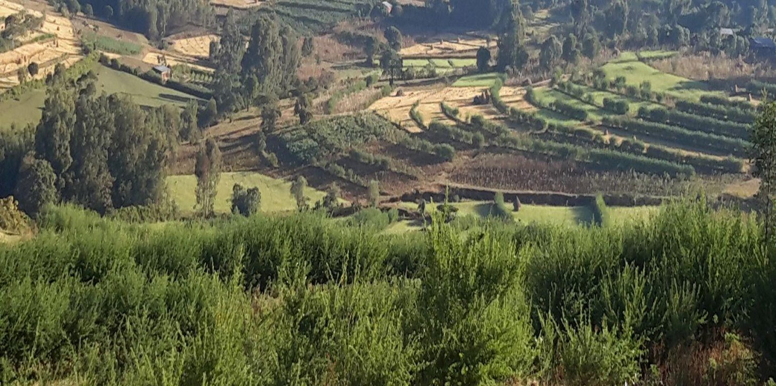
Hedgerows of vegetative graded bunds in Gosh Learning Watershed (Gizaw Desta (WLRC))

Vegetated graded soil bund (Ethiopia)

Yeafer Erken (Amharic)

Description

Vegetated graded soil bund is a soil conservation practice meant for cultivated lands and constructed by excavating graded channel on upper side and develop embankment on lower side which is planted with grass or shrub species in order to control soil erosion and drain excess runoff implemented through community mobilization.

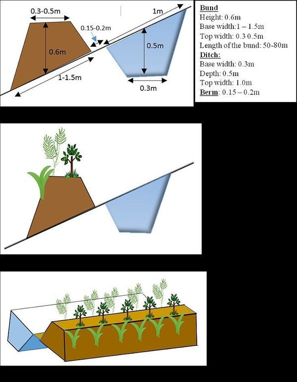
Vegetated graded soil bund is a practice or soil conservation technology for cultivated lands and constructed by excavating graded channel and form embankment. It is practiced in areas where there is excess runoff to be disposed and where there is no stones available for construction. The design specifications (ditch gradient, width and height) and layout (spacing/vertical interval) vary on the amount of excess runoff and slope of the land. Soil bund construction begins from top of the catchment. Cut off drains are constructed on top of the catchment and where needed to drain excess runoff to well stabilized natural or man-made waterways. this helps to reduce runoff impact on gullies. The bund ditch/channel should be sufficient enough to drain excess runoff safely without causing channel erosion and creating downstream damages. At same time the embankment should be stable to withstand overflows and damage due to free grazing. One technique to stabilize bunds is to plant the embankment with grass and shrub species of multiple economic value in order to compensate production area lost by bund construction. Often, the species are preferably used for livestock feed. Thus, free grazing has to be controlled. To protect damage of channels and embankments by extreme runoff and floods, frequent supervision and maintenance is required.

The purposes are:
1) Reduce nutrient loss and soil erosion by shortening the slope length,
2) Safely drain excess runoff from upstream of gully into protected waterways,
4) Produce biomass of fodder and cash values.

Vegetated graded bunds are established by doing surveying using hand level to determine the layout of the technology along the slope. During the surveying, the position of bunds (spacing) and cutoff drains and connection to waterways are determined. Bunds are laid following 0.05% gradient and up to 80 m maximum length. The specifications of the structure are: height of bund is a minimum of 60 cm after compaction; depending on the soil, base width range between 1.0 and 1.5m; top width is between 30 and 50 cm. The construction is made across different parcels owned by different land users. If there is no natural waterways and where it is appropriate, paved waterways are constructed at every 80 m or less bund length to dispose drainage water. At the beginning of the rainy season, the embankments are covered with grass and/or shrubs either by direct sowing of seeds or planting the seedlings raised in the nurseries. Monitoring of damages due to flooding and animals, maintenance of the structure as well as replanting of dead seedlings on bunds is required to sustain the soil conservation technology.

The technology is appropriately applied in high rainfall and sub-humid areas of the sub-tropics, particularly where the soil is moderately deep and poorly drained. It is constructed on cultivated lands having slopes in the range of 3-15%. The practice can be constructed by land users. It also requires collective decision and actions to drain excess runoff through waterways. The living condition depends on subsistence crop-livestock mixed farming. On average households have 5-6 family size. Crop production is meant for home consumption with small surplus for local market. The services related to water supply, energy supply, and infrastructure are low. Besides it is an asset, animals often used to cope shocks during drought periods.

Location

Location: Mecha, Bahirdar Zuria and Yilmana Densa, Amhara National Regional State (ANRS), Ethiopia

No. of Technology sites analysed:

Geo-reference of selected sites
  • n.a.

Spread of the Technology:

In a permanently protected area?:

Date of implementation: less than 10 years ago (recently)

Type of introduction
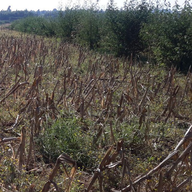
Susbania mixed with napier vegetative soil bund in Debre Mewi Learning Watershed (Gizaw Desta (Water and Land Resource Center))

Classification of the Technology

Main purpose
  • improve production
  • reduce, prevent, restore land degradation
  • conserve ecosystem
  • protect a watershed/ downstream areas – in combination with other Technologies
  • preserve/ improve biodiversity
  • reduce risk of disasters
  • adapt to climate change/ extremes and its impacts
  • mitigate climate change and its impacts
  • create beneficial economic impact
  • create beneficial social impact
Land use

  • Cropland
    • Annual cropping
    • Perennial (non-woody) cropping
    • Tree and shrub cropping
    Number of growing seasons per year: 1
  • Grazing land
    • free grazing
Water supply
  • rainfed
  • mixed rainfed-irrigated
  • full irrigation

Purpose related to land degradation
  • prevent land degradation
  • reduce land degradation
  • restore/ rehabilitate severely degraded land
  • adapt to land degradation
  • not applicable
Degradation addressed
  • soil erosion by water - Wt: loss of topsoil/ surface erosion, Wo: offsite degradation effects
  • water degradation - Hs: change in quantity of surface water
SLM group
  • cross-slope measure
SLM measures
  • vegetative measures - V1: Tree and shrub cover, V2: Grasses and perennial herbaceous plants
  • structural measures - S2: Bunds, banks, S3: Graded ditches, channels, waterways

Technical drawing

Technical specifications
Vegetated graded soil bund showing the excavated ditch or channel and the embankment planted with grass and shrubs
Location: Amhara Region. Mecha, Yilmana Densa, Bahir Dar Zuria and Dessie Z

Technical knowledge required for field staff / advisors: high (Layout and design specification of soil bunds and cutoff drains vary on soil types, slopes, and rainfall conditions. Experts thus should acquire knowledge on specific hydrologic conditions)
Technical knowledge required for land users: moderate (Land users need skill to layout and construct bunds, monitor structures before the occurrence of excessive damage, and do regular maintenance)

Main technical functions: control of dispersed runoff: impede / retard, reduction of slope length, sediment retention / trapping, sediment harvesting, increase of biomass (quantity)
Secondary technical functions: control of dispersed runoff: retain / trap, reduction of slope angle, increase / maintain water stored in soil, increase of groundwater level / recharge of groundwater

Aligned: -graded strips
Vegetative material: T : trees / shrubs, C : perennial crops, G : grass
Number of plants per (ha): T=5333, C=160, G=1600
Vertical interval between rows / strips / blocks (m): 1-1.5
Spacing between rows / strips / blocks (m): 10-20
Vertical interval within rows / strips / blocks (m): T=0.3, C=5, G=0.5
Width within rows / strips / blocks (m): 0.3
Trees/ shrubs species: Cordia Africana, Polycantha, Sesbania Susban, Pigeon pea, Treelucer
Perennial crops species: Rhamnus
Grass species: Napier grass
Slope (which determines the spacing indicated above): 3-15%
Gradient along the rows / strips: 0.05%
Diversion ditch/ drainage
Depth of ditches/pits/dams (m): 0.3-0.7
Width of ditches/pits/dams (m): 1.2-2.8
Length of ditches/pits/dams (m): 100-250

Waterway
Depth of ditches/pits/dams (m): 0.3
Width of ditches/pits/dams (m): 1.5-2.0

Bund/ bank: graded
Vertical interval between structures (m): 1-1.5
Spacing between structures (m): 10-20
Depth of ditches/pits/dams (m): 0.5
Width of ditches/pits/dams (m): 0.3
Height of bunds/banks/others (m): 0.6
Width of bunds/banks/others (m): 1-1.5
Length of bunds/banks/others (m): 50-80

Construction material (earth): in-situ excavated soil
Slope (which determines the spacing indicated above): 3-15%
Lateral gradient along the structure: 0.05%
Vegetation is used for stabilisation of structures.
Author: Bekure Melesse, WLRC, P.O.Box 8707, Addis Ababa, Ethiopia

Establishment and maintenance: activities, inputs and costs

Calculation of inputs and costs
  • Costs are calculated:
  • Currency used for cost calculation: ETH BIRR
  • Exchange rate (to USD): 1 USD = 20.0 ETH BIRR
  • Average wage cost of hired labour per day: 2.50
Most important factors affecting the costs
The cost variation in implementing vegetated soil bund is dependent upon availability of stones, workability of the soil, cost of seeds or seedlings for plantation, and distance for transporting seedlings.
Establishment activities
  1. Preparing planting materials (Timing/ frequency: January-May)
  2. Preparation of planting materials (Timing/ frequency: January-May)
  3. Transportation of grass splits/cuttings (Timing/ frequency: Start of rainy season/July)
  4. Transporting tree seedlings (Timing/ frequency: Start of rain season/July)
  5. Planting grass splits/cuttings (Timing/ frequency: Start of rainy season/July)
  6. Sowing seeds on bunds (Timing/ frequency: Start of rainy season/July)
  7. Planting tree seedlings on bunds (Timing/ frequency: Starting of rainy season/July)
  8. Surveying (layout of structures) (Timing/ frequency: After crop harvest and before first tillage operation)
  9. Construction of cutoff drains (Timing/ frequency: January-April)
  10. Construction of bunds (ditch and embankment) (Timing/ frequency: January-April)
  11. Construction of waterways (Timing/ frequency: January - April)
Establishment inputs and costs
Specify input Unit Quantity Costs per Unit (ETH BIRR) Total costs per input (ETH BIRR) % of costs borne by land users
Labour
labour ha 1.0 1107.0 1107.0 79.0
Equipment
animal traction ha 1.0 4.0 4.0 100.0
tools ha 1.0 300.6 300.6 50.0
Plant material
seedlings ha 1.0 32.0 32.0 100.0
seeds ha 1.0 9.0 9.0 100.0
compost manure ha 1.0 2.0 2.0 100.0
Construction material
stone ha 1.0 1300.0 1300.0 100.0
wood ha 1.0 110.0 110.0 100.0
earth ha 1.0 25.2 25.2 100.0
Total costs for establishment of the Technology 2'889.8
Total costs for establishment of the Technology in USD 144.49
Maintenance activities
  1. Preparation of planting materials (Timing/ frequency: January - May)
  2. Transportation of seedlings (Timing/ frequency: July)
  3. Re-plantation of seedlings and grass splits (Timing/ frequency: July)
  4. Maintenance of bunds, cutoff drain and waterways (Timing/ frequency: January-April)
Maintenance inputs and costs
Specify input Unit Quantity Costs per Unit (ETH BIRR) Total costs per input (ETH BIRR) % of costs borne by land users
Labour
labour ha 1.0 279.0 279.0 100.0
Plant material
seedlings ha 1.0 20.0 20.0 100.0
Total costs for maintenance of the Technology 299.0
Total costs for maintenance of the Technology in USD 14.95

Natural environment

Average annual rainfall
  • < 250 mm
  • 251-500 mm
  • 501-750 mm
  • 751-1,000 mm
  • 1,001-1,500 mm
  • 1,501-2,000 mm
  • 2,001-3,000 mm
  • 3,001-4,000 mm
  • > 4,000 mm
Agro-climatic zone
  • humid
  • sub-humid
  • semi-arid
  • arid
Specifications on climate
Monsoon, 5-6 months rain and 6-7 dry months
Thermal climate class: subtropics. he lowest temperature is above 5oc but below 18oc etween November to January
Slope
  • flat (0-2%)
  • gentle (3-5%)
  • moderate (6-10%)
  • rolling (11-15%)
  • hilly (16-30%)
  • steep (31-60%)
  • very steep (>60%)
Landforms
  • plateau/plains
  • ridges
  • mountain slopes
  • hill slopes
  • footslopes
  • valley floors
Altitude
  • 0-100 m a.s.l.
  • 101-500 m a.s.l.
  • 501-1,000 m a.s.l.
  • 1,001-1,500 m a.s.l.
  • 1,501-2,000 m a.s.l.
  • 2,001-2,500 m a.s.l.
  • 2,501-3,000 m a.s.l.
  • 3,001-4,000 m a.s.l.
  • > 4,000 m a.s.l.
Technology is applied in
  • convex situations
  • concave situations
  • not relevant
Soil depth
  • very shallow (0-20 cm)
  • shallow (21-50 cm)
  • moderately deep (51-80 cm)
  • deep (81-120 cm)
  • very deep (> 120 cm)
Soil texture (topsoil)
  • coarse/ light (sandy)
  • medium (loamy, silty)
  • fine/ heavy (clay)
Soil texture (> 20 cm below surface)
  • coarse/ light (sandy)
  • medium (loamy, silty)
  • fine/ heavy (clay)
Topsoil organic matter content
  • high (>3%)
  • medium (1-3%)
  • low (<1%)
Groundwater table
  • on surface
  • < 5 m
  • 5-50 m
  • > 50 m
Availability of surface water
  • excess
  • good
  • medium
  • poor/ none
Water quality (untreated)
  • good drinking water
  • poor drinking water (treatment required)
  • for agricultural use only (irrigation)
  • unusable
Water quality refers to:
Is salinity a problem?
  • Ja
  • Nee

Occurrence of flooding
  • Ja
  • Nee
Species diversity
  • high
  • medium
  • low
Habitat diversity
  • high
  • medium
  • low

Characteristics of land users applying the Technology

Market orientation
  • subsistence (self-supply)
  • mixed (subsistence/ commercial)
  • commercial/ market
Off-farm income
  • less than 10% of all income
  • 10-50% of all income
  • > 50% of all income
Relative level of wealth
  • very poor
  • poor
  • average
  • rich
  • very rich
Level of mechanization
  • manual work
  • animal traction
  • mechanized/ motorized
Sedentary or nomadic
  • Sedentary
  • Semi-nomadic
  • Nomadic
Individuals or groups
  • individual/ household
  • groups/ community
  • cooperative
  • employee (company, government)
Gender
  • women
  • men
Age
  • children
  • youth
  • middle-aged
  • elderly
Area used per household
  • < 0.5 ha
  • 0.5-1 ha
  • 1-2 ha
  • 2-5 ha
  • 5-15 ha
  • 15-50 ha
  • 50-100 ha
  • 100-500 ha
  • 500-1,000 ha
  • 1,000-10,000 ha
  • > 10,000 ha
Scale
  • small-scale
  • medium-scale
  • large-scale
Land ownership
  • state
  • company
  • communal/ village
  • group
  • individual, not titled
  • individual, titled
Land use rights
  • open access (unorganized)
  • communal (organized)
  • leased
  • individual
Water use rights
  • open access (unorganized)
  • communal (organized)
  • leased
  • individual
Access to services and infrastructure
health

poor
x
good
education

poor
x
good
technical assistance

poor
x
good
employment (e.g. off-farm)

poor
x
good
markets

poor
x
good
energy

poor
x
good
roads and transport

poor
x
good
drinking water and sanitation

poor
x
good
financial services

poor
x
good

Impacts

Socio-economic impacts
Crop production
decreased
x
increased


Crop yield increase on sedimentation area of bunds

fodder production
decreased
x
increased


Introduction of fodder crops on bunds

fodder quality
decreased
x
increased


Introduction of high value forage crops

production area (new land under cultivation/ use)
decreased
x
increased


The area used for ditch construction can be taken as a loss of land

land management
hindered
x
simplified


In slope classes where spacing is narrow farm operation will be hindered

farm income
decreased
x
increased


Increase in income due to yield increase and fodder production

Socio-cultural impacts
community institutions
weakened
x
strengthened


Watershed users committee established to regulate the development

SLM/ land degradation knowledge
reduced
x
improved


Field staffs and land users aware of erosion and soil conservation

conflict mitigation
worsened
x
improved

Ecological impacts
water quantity
decreased
x
increased


Overall effect of bunds show increase in surface water downstreams

surface runoff
increased
x
decreased


reduction of concentrated runoff

soil moisture
decreased
x
increased


Increase the rate of infiltration

soil loss
increased
x
decreased


Soil loss is reduced by breaking the slope length

Off-site impacts
reliable and stable stream flows in dry season (incl. low flows)
reduced
x
increased


In good drainage soils it increases infiltrated water and interflows

downstream flooding (undesired)
increased
x
reduced


Since it helps to reduce concentration of runoff it contributes to reduce flooding

downstream siltation
increased
x
decreased


The main function of bunds is to reduce soil loss

damage on neighbours' fields
increased
x
reduced


All fields are treated with integrated bund, cutoff drain and waterways

Cost-benefit analysis

Benefits compared with establishment costs
Short-term returns
very negative
x
very positive

Long-term returns
very negative
x
very positive

Benefits compared with maintenance costs
Short-term returns
very negative
x
very positive

Long-term returns
very negative
x
very positive

The short term economic benefits of the technology includes increase in fodder production and slightly crop productivity due to improved soil moisture. Whereas the long term benefit can be obtained as a result of increased yield on areas where sediment accumulation occurs as well as production of fodder on soil bunds for livestock feed

Climate change

Climate-related extremes (disasters)
local rainstorm

not well at all
x
very well
general (river) flood

not well at all
x
very well

Adoption and adaptation

Percentage of land users in the area who have adopted the Technology
  • single cases/ experimental
  • 1-10%
  • 11-50%
  • > 50%
Of all those who have adopted the Technology, how many have done so without receiving material incentives?
  • 0-10%
  • 11-50%
  • 51-90%
  • 91-100%
Has the Technology been modified recently to adapt to changing conditions?
  • Ja
  • Nee
To which changing conditions?
  • climatic change/ extremes
  • changing markets
  • labour availability (e.g. due to migration)

Conclusions and lessons learnt

Strengths: land user's view
  • Increase in fodder production for livestock feed
  • Reduce conflict among adjacent land users (i.e., upstream and downstream land users) that arise due to concentrated runoff
  • Reduce soil erosion
Strengths: compiler’s or other key resource person’s view
  • The technology reduces soil loss and associated nutrient loss significantly in the first 3 to 4 years and further reduce siltation of reservoirs and land degradation
  • Increase the soil moisture in the landscape/watershed
  • Improves the greenness, soil carbon and micro-climate
  • Increase level of awareness of land users to produce fodder and diversify production and income
  • Reduce the concentration of runoff and safely drain without causing damage
Weaknesses/ disadvantages/ risks: land user's viewhow to overcome
  • Hinder farm operations like turning oxen become difficult while ploughing It can be sustained through proper layout and allow space for human and animal paths
  • Plantation on bunds harbor birds This can be avoided by harvesting the mature branches of the shrubs for livestock feed on seasonal basis.
  • Appearance of new weeds species along the drainage ditches Regular weed monitoring and manual control
  • Hinders livestock to graze on crop residues Try to use cut and carry grazing system (both crop residues and fodders) and develop forage development strategies in every possible niches
Weaknesses/ disadvantages/ risks: compiler’s or other key resource person’s viewhow to overcome
  • High labor requirement to establish and maintain the technology Increase the awareness level of land users and strength collective actions and local organizational setups
  • Small land loss for construction Introduce production options (like fodder production) on bunds to compensate the lost land
  • It requires some years to accumulate sediment on bund area and form bench It can be improved by modifying the design of drainage ditchs

References

Compiler
  • Gizaw Desta Gessesse
Editors
Reviewer
  • Deborah Niggli
  • Alexandra Gavilano
Date of documentation: Mei 12, 2014
Last update: Sept. 10, 2019
Resource persons
Full description in the WOCAT database
Linked SLM data
Documentation was faciliated by
Institution Project
Key references
  • Vegetated Graded Soil Bund: A Technique to Reduce Runoff Impact and Increase Soil Moisture Storage and Fodder Biomass, WLRC Brief No. 4: WWW.wlrc-eth.org
This work is licensed under Creative Commons Attribution-NonCommercial-ShareaAlike 4.0 International