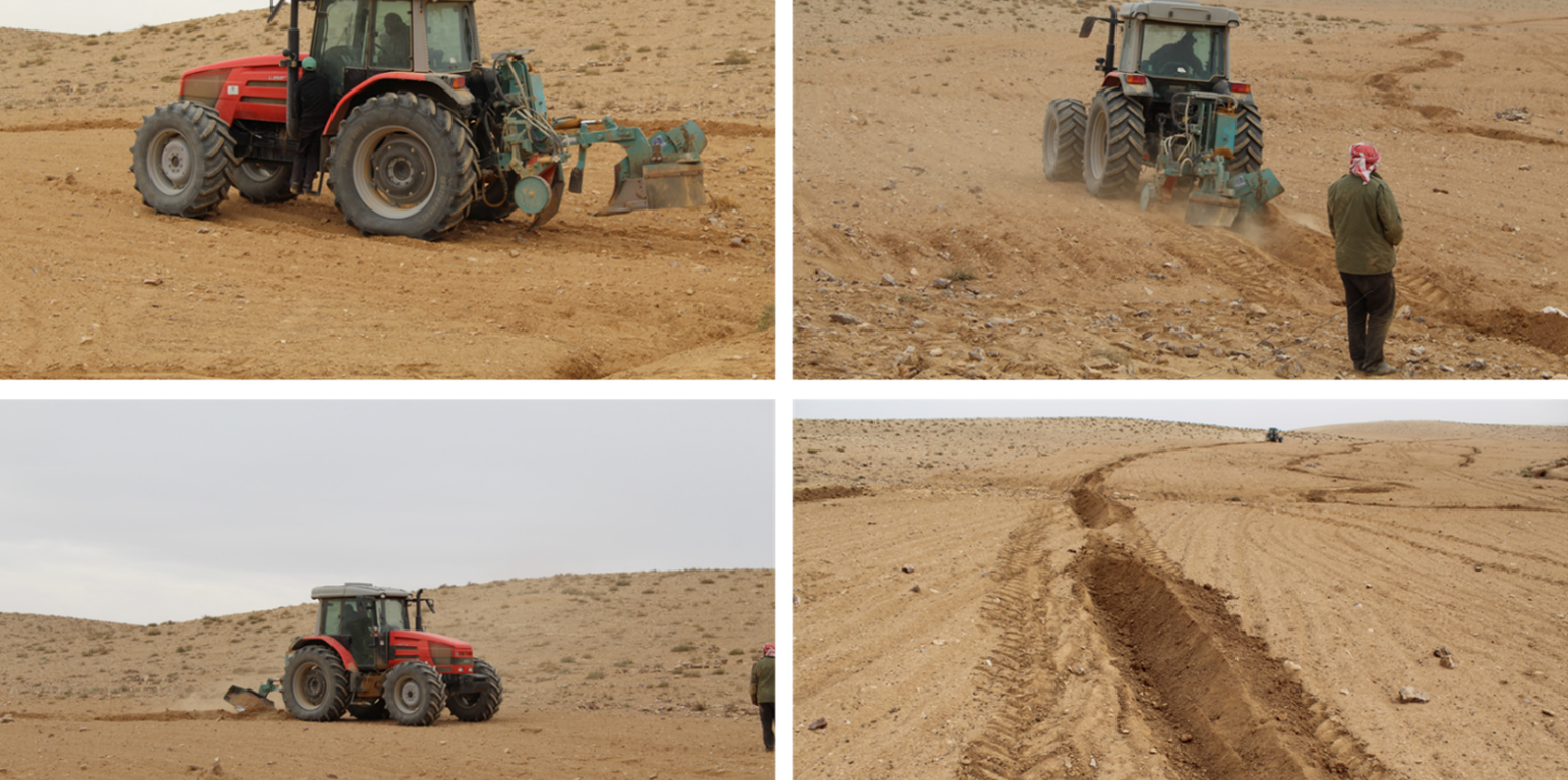
Site Implementation using the Vallerani Machine - Dec. 2016 (Mira Haddad)

Mechanized micro water harvesting through ‘Vallerani’ tractor plough for central Jordanian Badia (Jordan)

Vallerani (تقنية حصاد المياه بالمساقط الصغيرة (الفاليراني)

Description

Mechanized micro water harvesting breaks up crusted and compacted soils, and fosters the capture and retention and the deep-infiltration of surface runoff generated during heavy rainfall events. The micro water harvesting pits store water and provide soil moisture to the out-planted shrub seedlings and the emerging seeds - and thus boosts the development of resilient vegetation patches towards the eventual rehabilitation of degraded rangelands.

The micro water harvesting technology is part of a larger watershed rehabilitation initiative; It is the most upstream technology used in an integrated approach, including upland rehabilitation (Vallerani), gully erosion control, and revegetation (gully plugs), and downstream local barley agriculture using the ‘Marab’ technology.

1: Main Elements: The Vallerani tractor plow (Delfino 50 MI/CM) (Gammoh & Oweis, 2011) constructs intermittent water harvesting pits along the contour of terrain and transects the hill slopes at approximately 5-10 m between lines. The local hill slope (at the implementation site) ranges between 2% and 15%. Pit length is adjustable and relates to the speed of the tractor. At the implementation site, pit lengths are around 4.5 m. In the micro water harvesting pits, several native shrub seedlings can be out-planted (at the site, 2 per pit).

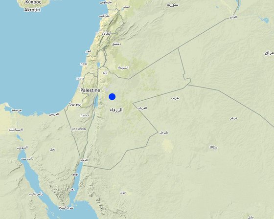
2: Where: This technology is used in a watershed context close to Al Majeddyeh village, located in the Middle Badia zone, approximately 30 km south-east of Amman. The climate is arid and warm (Palmer, 2013). The average annual rainfall is around 130 mm. The natural environment is classified as steppe, Bsh in the köppen classification. The human environment is characterized by agropastoralists. They are semi-nomadic and live in villages around the watershed, for example, Al Majeddyeh village.

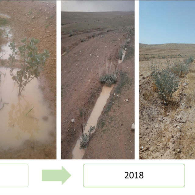
3: The purpose of the technology: Breaking the land degradation cycle by retaining and encouraging deep-infiltration of surface runoff, which supports native vegetation growth. The stored soil moisture boosts the growth of both out-planted shrub seedlings and emerging local seeds towards healthy and resilient vegetation patches. Over time, the plowed pits degrade, but vegetation takes over the dryland hydrological functions of rainfall interception, runoff deceleration, and fostering infiltration. The developing shrubland provides various ecosystem services, predominately fodder for livestock of local agropastoralists.

4: Major activities: 1) Mechanized micro water harvesting establishment through the Vallerani tractor plow. 2) plantation of native seedlings in the pits (2 shrubs per pit at the local site). 3) Manage rangelands through sustainable grazing.

5: Impact: The technology breaks up the degradation cycle, increases soil moisture, and eventually boosts vegetation development and biodiversity. Through retention of runoff, sediments and residues, it decreases erosion and enhances organic carbon storage. It reduces peak surface runoff and thus mitigates flooding. The enhanced biomass supports livestock (grazing) and reduces agricultural inputs required (such as those required for low input barley production).

6: Land users' opinion: Land users evaluate the technology ambivalently. In the short term, landowners are often skeptical, because the rehabilitation requires a recovery time and strict non-grazing/resting for (usually) the first 2 rainy seasons. Thereafter, the rehabilitated lands require sustainable management. Later, after vegetation development, most landowners are convinced of the improvements and understand the economic and environmental value. The acceptance strongly depends on the social and cultural context – many farmers continue preferring the already established barley monoculture, mainly due to lack of sustainable rangeland management options and land ownership. However, well-targeted awareness campaigns can be supportive.

Location

Location: Al Majeddyeh Village, Amman governorates /Al Jiza District/Al Majeddyeh Village, Jordan

No. of Technology sites analysed: single site

Geo-reference of selected sites
  • 36.1256, 31.71782

Spread of the Technology: evenly spread over an area (30.0 km²)

In a permanently protected area?: Nee

Date of implementation: 2016

Type of introduction
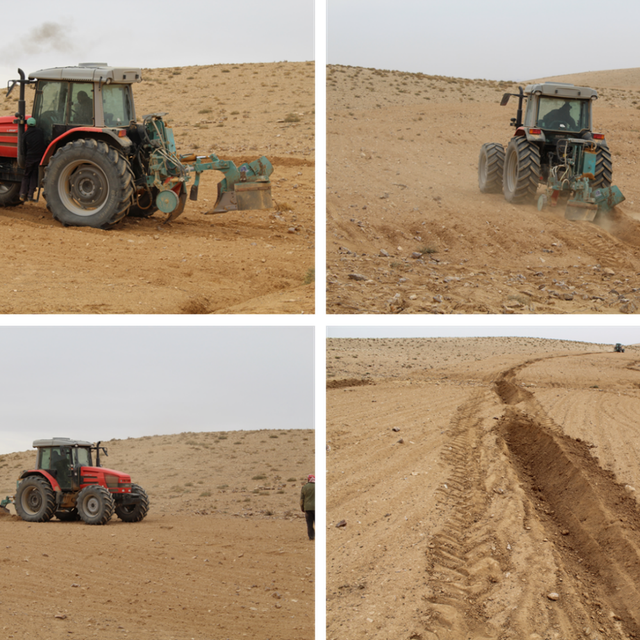
Site Implementation (Mira Haddad)
Plant growth in the Vallerani water harvesting

Classification of the Technology

Main purpose
  • improve production
  • reduce, prevent, restore land degradation
  • conserve ecosystem
  • protect a watershed/ downstream areas – in combination with other Technologies
  • preserve/ improve biodiversity
  • reduce risk of disasters
  • adapt to climate change/ extremes and its impacts
  • mitigate climate change and its impacts
  • create beneficial economic impact
  • create beneficial social impact
Land use
Land use mixed within the same land unit: Nee

  • Grazing land
    • Semi-nomadic pastoralism
    • Improved pastures
    • Grazing Management plan
    Animal type: goats, sheep
    Is integrated crop-livestock management practiced? Ja
      SpeciesCount
      goats300
      sheep50
    • Other - Specify: Restoration
      Remarks: Planting of native shrub species: Atriplex Halimus, Retama, and Salsola.

    Water supply
    • rainfed
    • mixed rainfed-irrigated
    • full irrigation

    Purpose related to land degradation
    • prevent land degradation
    • reduce land degradation
    • restore/ rehabilitate severely degraded land
    • adapt to land degradation
    • not applicable
    Degradation addressed
    • soil erosion by water - Wt: loss of topsoil/ surface erosion, Wg: gully erosion/ gullying, Wo: offsite degradation effects
    • soil erosion by wind - Et: loss of topsoil, Ed: deflation and deposition, Eo: offsite degradation effects
    • chemical soil deterioration - Cn: fertility decline and reduced organic matter content (not caused by erosion)
    • physical soil deterioration - Pc: compaction, Pk: slaking and crusting
    • biological degradation - Bc: reduction of vegetation cover, Bh: loss of habitats, Bs: quality and species composition/ diversity decline, Bl: loss of soil life
    • water degradation - Ha: aridification, Hs: change in quantity of surface water
    SLM group
    • improved ground/ vegetation cover
    • cross-slope measure
    • water harvesting
    SLM measures
    • agronomic measures - A4: Subsurface treatment, A6: Residue management
    • vegetative measures - V2: Grasses and perennial herbaceous plants, V5: Others
    • structural measures - S2: Bunds, banks, S11: Others
    • management measures - M2: Change of management/ intensity level, M3: Layout according to natural and human environment, M4: Major change in timing of activities, M5: Control/ change of species composition, M7: Others
    • other measures - Specify tillage system: reduced tillage (> 30% soil cover) Specify residue management: grazed Comments/ remarks: Vegetation biomass is used as fodder for livestock as well as retained (for recruitment) – managed through a sustainable grazing plan. The technology consists of a combination of structural and re-vegetative measures. The structural measure provides the opportunity for vegetation development beyond the out-planted species.

    Technical drawing

    Technical specifications
    The dimensions of the water harvesting pits, constructed by the Vallerani tractor plow, are 4.5m, 0.5m, and 0.3m in length, width, and depth. With those dimensions, the effective water capturing total volume of one pit reaches approximately 0.2 to 0.3 m3 – depending on the formation process (e.g., depending on terrain, local soil, tractor speed). The interspace between the contours of water harvesting pits (in downslope direction) is approximately 7 meters at the implementation site. However, interspace strongly varies due to local terrain, soil, and rainfall pattern. The lateral spacing between pits is around 0.5m-1.0m.
    Two local shrub seedlings of either Atriplex Halimus, Retama, or Salsola have been out-planted in the pit. These plants are native (adapted to the local environment) and drought tolerant. However, the early stage seedlings are vulnerable, and micro water harvesting substantially increases survival and fast development and allows the cumulation of top-soil, residues, and seed material.
    At the specific site, micro water harvesting was established on slopes varying between 2% and 15%. The local rehabilitated area is around 10 hectares large. Around 1500 pits have been developed corresponding to 3000 planted shrub seedlings.
    Author: Sayo Fukai

    Establishment and maintenance: activities, inputs and costs

    Calculation of inputs and costs
    • Costs are calculated: per Technology area (size and area unit: 1ha)
    • Currency used for cost calculation: USD
    • Exchange rate (to USD): 1 USD = n.a
    • Average wage cost of hired labour per day: n.a
    Most important factors affecting the costs
    The most important cost is the high-quality seedlings and the local labor costs. Both can be reduced.
    Establishment activities
    1. Site Selection (biophysical suitability) (Timing/ frequency: At least 1 year prior implementation)
    2. Site inspection & local community consultation (social assessment, awareness and planning) (Timing/ frequency: Around 1 year prior implementation)
    3. Ploughing of micro water harvesting pits along the contour (e.g. laser guided) (Timing/ frequency: Late dry season (at least 1 month prior rainy season onset))
    4. Out-planting of native shrubs seedlings (e.g. Atriplex and Ratameh) – potentially community inclusive activity (Timing/ frequency: After first substantial rainfall (e.g. > 5mm rainfall event))
    5. Sustainable management by the local community (grazing and resting plan) (Timing/ frequency: Approximately after 2 years (sustainable grazing includes certain resting – chance for seeds production and recruitment))
    Establishment inputs and costs (per 1ha)
    Specify input Unit Quantity Costs per Unit (USD) Total costs per input (USD) % of costs borne by land users
    Labour
    Tractor plough operation Labour Day per hectare 0.2 25.0 5.0
    Technical assistance LD 0.2 50.0 10.0
    Seedling planters (local community) LD 5.0 20.0 100.0
    Equipment
    Tractor + Vallerani Plough (transport & fuel) Day 0.2 200.0 40.0
    Field equipment Day 1.0 20.0 20.0
    Plant material
    Atriplex Halimus Seedling 100.0 0.5 50.0
    Retama Seedling 100.0 0.5 50.0
    Salsola Seedling 100.0 0.5 50.0
    Other
    Transportation and storage (e.g. seedlings) Lumpsum per hectare 1.0 20.0 20.0
    Total costs for establishment of the Technology 345.0
    Total costs for establishment of the Technology in USD 345.0
    Maintenance activities
    1. Sustainable grazing (take half / leave half concept) (Timing/ frequency: 1-2 times per season)
    2. Cut and carry (Timing/ frequency: locally)
    3. Resting for shrub-seed production and new recruitment (Timing/ frequency: Some selected resting seasons)

    Natural environment

    Average annual rainfall
    • < 250 mm
    • 251-500 mm
    • 501-750 mm
    • 751-1,000 mm
    • 1,001-1,500 mm
    • 1,501-2,000 mm
    • 2,001-3,000 mm
    • 3,001-4,000 mm
    • > 4,000 mm
    Agro-climatic zone
    • humid
    • sub-humid
    • semi-arid
    • arid
    Specifications on climate
    Average annual rainfall in mm: 130.0
    Jordan has a rainy season from September to May – but locally, the effective rainy season sets on later (November or December) and lasts until April.
    The average annual rainfall on-site for the recent three years is approximately 130 mm.
    Name of the meteorological station: Queen Alia international airport reference station reports long term average annual rainfall of about 150 mm A rainfall tipping bucket installed in the site in 2016.
    The maximum temperature usually occurred between July and August.
    The average daily maximum temperature is 25.01 °C.
    The average daily minimum temperature is 8.5 °C
    Slope
    • flat (0-2%)
    • gentle (3-5%)
    • moderate (6-10%)
    • rolling (11-15%)
    • hilly (16-30%)
    • steep (31-60%)
    • very steep (>60%)
    Landforms
    • plateau/plains
    • ridges
    • mountain slopes
    • hill slopes
    • footslopes
    • valley floors
    Altitude
    • 0-100 m a.s.l.
    • 101-500 m a.s.l.
    • 501-1,000 m a.s.l.
    • 1,001-1,500 m a.s.l.
    • 1,501-2,000 m a.s.l.
    • 2,001-2,500 m a.s.l.
    • 2,501-3,000 m a.s.l.
    • 3,001-4,000 m a.s.l.
    • > 4,000 m a.s.l.
    Technology is applied in
    • convex situations
    • concave situations
    • not relevant
    Soil depth
    • very shallow (0-20 cm)
    • shallow (21-50 cm)
    • moderately deep (51-80 cm)
    • deep (81-120 cm)
    • very deep (> 120 cm)
    Soil texture (topsoil)
    • coarse/ light (sandy)
    • medium (loamy, silty)
    • fine/ heavy (clay)
    Soil texture (> 20 cm below surface)
    • coarse/ light (sandy)
    • medium (loamy, silty)
    • fine/ heavy (clay)
    Topsoil organic matter content
    • high (>3%)
    • medium (1-3%)
    • low (<1%)
    Groundwater table
    • on surface
    • < 5 m
    • 5-50 m
    • > 50 m
    Availability of surface water
    • excess
    • good
    • medium
    • poor/ none
    Water quality (untreated)
    • good drinking water
    • poor drinking water (treatment required)
    • for agricultural use only (irrigation)
    • unusable
    Water quality refers to: ground water
    Is salinity a problem?
    • Ja
    • Nee

    Occurrence of flooding
    • Ja
    • Nee
    Species diversity
    • high
    • medium
    • low
    Habitat diversity
    • high
    • medium
    • low

    Characteristics of land users applying the Technology

    Market orientation
    • subsistence (self-supply)
    • mixed (subsistence/ commercial)
    • commercial/ market
    Off-farm income
    • less than 10% of all income
    • 10-50% of all income
    • > 50% of all income
    Relative level of wealth
    • very poor
    • poor
    • average
    • rich
    • very rich
    Level of mechanization
    • manual work
    • animal traction
    • mechanized/ motorized
    Sedentary or nomadic
    • Sedentary
    • Semi-nomadic
    • Nomadic
    Individuals or groups
    • individual/ household
    • groups/ community
    • cooperative
    • employee (company, government)
    Gender
    • women
    • men
    Age
    • children
    • youth
    • middle-aged
    • elderly
    Area used per household
    • < 0.5 ha
    • 0.5-1 ha
    • 1-2 ha
    • 2-5 ha
    • 5-15 ha
    • 15-50 ha
    • 50-100 ha
    • 100-500 ha
    • 500-1,000 ha
    • 1,000-10,000 ha
    • > 10,000 ha
    Scale
    • small-scale
    • medium-scale
    • large-scale
    Land ownership
    • state
    • company
    • communal/ village
    • group
    • individual, not titled
    • individual, titled
    Land use rights
    • open access (unorganized)
    • communal (organized)
    • leased
    • individual
    Water use rights
    • open access (unorganized)
    • communal (organized)
    • leased
    • individual
    • NA
    Access to services and infrastructure
    health

    poor
    good
    education

    poor
    good
    technical assistance

    poor
    good
    employment (e.g. off-farm)

    poor
    good
    markets

    poor
    good
    energy

    poor
    good
    roads and transport

    poor
    good
    drinking water and sanitation

    poor
    good
    financial services

    poor
    good

    Impacts

    Socio-economic impacts
    fodder production
    decreased
    increased

    fodder quality
    decreased
    increased

    animal production
    decreased
    increased

    product diversity
    decreased
    increased

    land management
    hindered
    simplified

    expenses on agricultural inputs
    increased
    decreased

    workload
    increased
    decreased

    Socio-cultural impacts
    food security/ self-sufficiency
    reduced
    improved

    recreational opportunities
    reduced
    improved

    SLM/ land degradation knowledge
    reduced
    improved

    Ecological impacts
    water quantity
    decreased
    increased

    harvesting/ collection of water (runoff, dew, snow, etc)
    reduced
    improved

    surface runoff
    increased
    decreased

    evaporation
    increased
    decreased

    soil moisture
    decreased
    increased

    soil cover
    reduced
    improved

    soil loss
    increased
    decreased

    soil accumulation
    decreased
    increased

    soil crusting/ sealing
    increased
    reduced

    soil organic matter/ below ground C
    decreased
    increased

    vegetation cover
    decreased
    increased

    biomass/ above ground C
    decreased
    increased

    plant diversity
    decreased
    increased

    invasive alien species
    increased
    reduced

    habitat diversity
    decreased
    increased

    flood impacts
    increased
    decreased

    impacts of cyclones, rain storms
    increased
    decreased

    micro-climate
    worsened
    improved

    Off-site impacts
    reliable and stable stream flows in dry season (incl. low flows)
    reduced
    increased

    downstream flooding (undesired)
    increased
    reduced

    downstream siltation
    increased
    decreased

    wind transported sediments
    increased
    reduced

    Cost-benefit analysis

    Benefits compared with establishment costs
    Short-term returns
    very negative
    very positive

    Long-term returns
    very negative
    very positive

    Benefits compared with maintenance costs
    Short-term returns
    very negative
    very positive

    Long-term returns
    very negative
    very positive

    Climate change

    Gradual climate change
    annual temperature increase

    not well at all
    very well
    annual rainfall decrease

    not well at all
    very well
    Climate-related extremes (disasters)
    local rainstorm

    not well at all
    very well
    extreme winter conditions

    not well at all
    very well
    flash flood

    not well at all
    very well

    Adoption and adaptation

    Percentage of land users in the area who have adopted the Technology
    • single cases/ experimental
    • 1-10%
    • 11-50%
    • > 50%
    Of all those who have adopted the Technology, how many have done so without receiving material incentives?
    • 0-10%
    • 11-50%
    • 51-90%
    • 91-100%
    Has the Technology been modified recently to adapt to changing conditions?
    • Ja
    • Nee
    To which changing conditions?
    • climatic change/ extremes
    • changing markets
    • labour availability (e.g. due to migration)
    • watershed approach and transition status of the structures
    Implementation efficiency increase through adding contour laser technique and using the reversible blade (2 directions plowing)

    Conclusions and lessons learnt

    Strengths: land user's view
    • Opportunity for agro-pastoralism (grazing up to twice a year)
    • Improved livestock health, milk quantity, and quality.
    • No input costs needed (compared with e.g. barley agriculture)
    • Flexibility in timing: grazing of healthy rangelands can be done ‘at any time’(certainly spring season is most beneficial for livestock) – which differs from barley agriculture approach.
    Strengths: compiler’s or other key resource person’s view
    • Besides out-planting of native shrub seedlings, native biodiversity evolves through the emergence of dormant seed material.
    • Out-planted shrub seedlings withstand extreme weather conditions (droughts) through water harvesting. The survival rate and eventual success of the rehabilitation approach are high.
    • Micro water harvesting structures and upcoming vegetation patches reduce erosion and increase trapping of sediments, including organic carbon and seed materials.
    • Water harvesting reduces the peak of surface runoff and thus mitigates downstream flooding
    Weaknesses/ disadvantages/ risks: land user's viewhow to overcome
    • Costs of implementation and availability of high-quality seedlings and the Vallerani plow. Develop large-scale procedure/initiative that allows farmers to request and restore vulnerable areas using the Vallerani micro-water harvesting technique. Include incentives for implementation (ex. free seedlings, free of charge using of Vallerani machine, subsidies on arley as fodder for the first two years in order for farmers to maintain the site)
    • Change: Not all farmers are willing to forgo barley agriculture Demonstrating the effects this technology through pilot projects. Local communities on the forefront of communication.
    • Vegetation growth may attract herders from different areas. Clear rules and legislation on land facilitation in terms of grazing.
    • Requires higher understanding of the environment and long-term planning Introduce knowledge sharing events to teach local farmers on the effects of land degradation and the benefits of healthy ecosystems
    Weaknesses/ disadvantages/ risks: compiler’s or other key resource person’s viewhow to overcome
    • Land ownership: current land tenure system in Jordan slows the adoption of the intervention. A landowner can reside in a city (no much value for the land), and the land user may be a herder. A large flock owner can rent huge areas for barley cultivation (actual cost of 1 donum of barley plantation ranges between 1.5-3 USD; possible to prepare up to 10 ha per day). Cheap labor/herders will move flocks and graze until all cover is gone (usually for 1-3 months maximum per year (March-May)). Rehabilitated areas will be of less interest for such users. Develop and apply strict land management plans and policies. Create a strong monitoring system. Apply penalties for actions that increase land degradation with various on-site and off-sites impacts
    • Lack of institutional collaboration for rangeland management and rehabilitation. Land management in the Badia is the responsibility of several ministries in Jordan. The lack of institutional collaboration and the absence of the rangeland areas' valuation create a difficult environment for sustainability measures. Increase the collaboration between ministries and stakeholders. Evaluate the impact of restoration solutions on the site and off site.
    • Lack of clear government policy for restoration, incentives for farmers, and funding availability. Develop a clear action plan among the responsible government institutions of restoration activities.
    • Complex social context. The majority of land users and/or landowners don’t value the restoration. The bare cultivation practices have more (quick) value without resting time. Capacity development for local communities for the value of soil, water, and biodiversity

    References

    Compiler
    • Mira Haddad
    Editors
    Reviewer
    • William Critchley
    • Rima Mekdaschi Studer
    Date of documentation: Maart 9, 2021
    Last update: Maart 29, 2021
    Resource persons
    Full description in the WOCAT database
    Linked SLM data
    Documentation was faciliated by
    Institution Project
    Key references
    • Akroush, S., & All, E. (2016). Factors Affecting the Adoption of Water Harvesting Technologies: A Case Study of Jordanian Arid Area. Sustainable Agriculture Research.:
    • Akroush, S., & Boubaker, D. (2015). Predicted Willingness of Farmers to Adopt Water Harvesting Technologies: A Case Study from the Jordanian Badia (Jordan). American-Eurasian J. Agricultural & Environmental science , 1502-1513.:
    • Gammoh, & Oweis. (2011). Performance and Adaptation of the Vallerani Mechanized Water Harvesting System in Degraded Badia Rangelands . Journal of Environmental Science and Engineering, 1370-1380.:
    • Haddad, M. (2019). Exploring Jordan's Rangeland Transition: Merging Restoration Eperiment with Modeling - A Case study from Al Majdiyya Village. Amman: The University of Jordan.:
    • Vallerani. (n.d.). Vallerani system. Retrieved from Vallerani: http://www.vallerani.com/wp/:
    Links to relevant information which is available online
    This work is licensed under Creative Commons Attribution-NonCommercial-ShareaAlike 4.0 International