Slope stabilisation and progressive terracing with vetiver grass (Joana Eichenberger)

Progressive bench terraces formed by a vetiver hedge system and trees (Haiti)

Ranp vivan (fran. rampes vivantes)

Description

Progressive terracing technology is established through successive deposits of sediments behind (upstream) any anti-erosional structure, in this case contour strips of vetiver grass (vetiveria zizanioides). To better stabilize the slopes in the long-term, trees are planted downstream of the vetiver hedges.

Vetiver hedges are applied to prevent degradation and increase slope stabilization on areas prone to erosion. In Haiti, the Swiss Red Cross (SRC) has used cross-slope vetiver hedges as a restoration measure where soil has been degraded by surface erosion. Terraces are progressively formed and these reshape steep-sloped terrain into a succession of platforms with little or no gradient. Over time, these areas receive deposits of sediments from upstream: these sediments are captured by the terraces. Vetiver grass is used to establish anti-erosive structures because it is a common, deep-rooted species that can also be cut and used as mulch. Below the vetiver hedges, fruit trees may be planted to better stabilize the soil and simultaneously improve food security. However, if the soil is too degraded, forest trees are an alternative as they are less demanding. Between the vetiver hedges, land users can cultivate crops. It is recommended not to plant root crops (potatoes, cassava etc) or even groundnuts, but rather to plant legumes that bear fruit above ground and fix nitrogen, and perennial crops. Vetiver may be cut and used for mulching on the terrace beds.
This technology has several on- and offsite benefits. Besides stabilizing slopes and reducing landslide risks, vetiver strips are proven to reduce and retain surface runoff in ditches just above the hedges. Therefore, rainfall water can infiltrate more easily and recharge groundwater. Another onsite advantage is the accumulation of fertile sediments on the terrace beds, which support cropping. Offsite benefits include downstream protection for communities and agricultural fields against landslides, floods and siltation. Despite these advantages, land users claim there is significant loss of arable area when applying this technology. Farmers tend to exploit their plots of cultivated land, and only apply vetiver terraces when the soil is completely degraded. This, however, means that the soil needs time to regenerate before it can be cultivated again. Therefore, although very protective, this technology is not necessarily productive immediately after its implementation on heavily degraded soil. Furthermore, the vetiver grass itself has little use for the land users. Although its roots contain aromatic oil that is highly sought after in the cosmetic industry, land users should not dig up vetiver roots as this would severely weaken the stabilizing function of the technology.
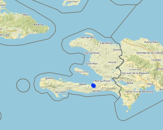
Location

Location: Léogâne, Département de l'Ouest, Haiti

No. of Technology sites analysed: 10-100 sites

Geo-reference of selected sites
  • -72.63595, 18.38481
  • -72.636, 18.38739
  • -72.65844, 18.40364

Spread of the Technology: evenly spread over an area (approx. 0.1-1 km2)

In a permanently protected area?: Nee

Date of implementation: 2014

Type of introduction
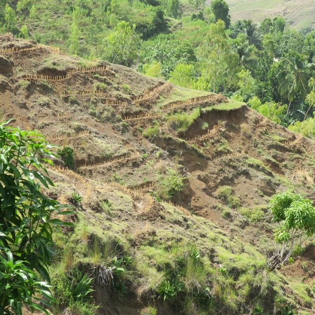
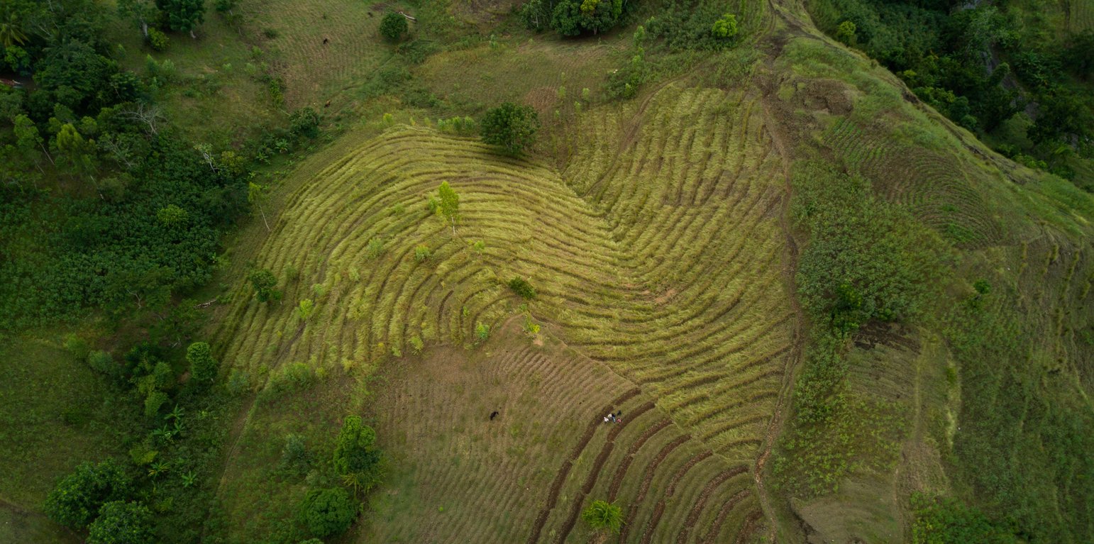
In Haiti, progressive terracing is rather a measure of restoration of severely degraded land. This photograph has been taken one month after the implementation of the technology. (Joana Eichenberger)
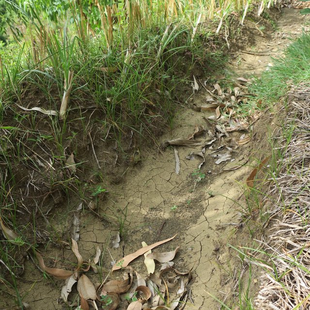
Behind each line of vetiver there is a small channel where water and sediments accumulate. (Joana Eichenberger)

Classification of the Technology

Main purpose
  • improve production
  • reduce, prevent, restore land degradation
  • conserve ecosystem
  • protect a watershed/ downstream areas – in combination with other Technologies
  • preserve/ improve biodiversity
  • reduce risk of disasters
  • adapt to climate change/ extremes and its impacts
  • mitigate climate change and its impacts
  • create beneficial economic impact
  • create beneficial social impact
  • adapt to steep slopes
Land use

  • Cropland
    • Annual cropping: oilseed crops - groundnuts, cereals - maize, legumes and pulses - beans, root/tuber crops - sweet potatoes, yams, taro/cocoyam, other
    • Perennial (non-woody) cropping: banana/plantain/abaca, pigeon peas
    Number of growing seasons per year: 2
    Is intercropping practiced? Ja
  • Forest/ woodlands
    • Tree plantation, afforestation. Varieties: Mixed varieties
    Tree types (deciduous): n.a.
    Products and services: Fruits and nuts, Nature conservation/ protection

Water supply
  • rainfed
  • mixed rainfed-irrigated
  • full irrigation

Purpose related to land degradation
  • prevent land degradation
  • reduce land degradation
  • restore/ rehabilitate severely degraded land
  • adapt to land degradation
  • not applicable
Degradation addressed
  • soil erosion by water - Wt: loss of topsoil/ surface erosion, Wg: gully erosion/ gullying, Wm: mass movements/ landslides, Wo: offsite degradation effects
  • water degradation - Ha: aridification, Hs: change in quantity of surface water, Hg: change in groundwater/aquifer level, Hp: decline of surface water quality
SLM group
  • agroforestry
  • cross-slope measure
  • ecosystem-based disaster risk reduction
SLM measures
  • agronomic measures - A2: Organic matter/ soil fertility
  • vegetative measures - V1: Tree and shrub cover, V2: Grasses and perennial herbaceous plants
  • structural measures - S1: Terraces

Technical drawing

Technical specifications
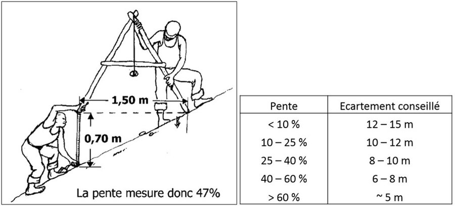
In order to implement this technology, the average slope has to be measured first. This is done with a "A-level"-called instrument. By placing one foot to the A-level and raising the lower foot (downstream in the direction of the slope), the A-level should be placed in a horizontal position. The slope corresponds to p=h/l*100, for p = slope, h = distance from the downstream foot of A-level to the ground, and l = distance between the two feet of level A. The average slope defines the distance between the vetiver lines. The steeper the slope, the smaller the distance.
Author: Régis and Roy
After having calculated the average slope of the terrain, one can start picketing the contour lines where the vetivers will be planted. First, an alignment in the direction of the slope from upstream to downstream is done by planting stakes. The first stake is placed at the upper limit of the plot, the distance the other stakes is a function of the average slope of the terrain (here: 50% --> 7m). This alignment forms the baseline. Once the baseline is set, the contour lines can be picketed. This is done again with the A-level instrument.
Author: Régis and Roy
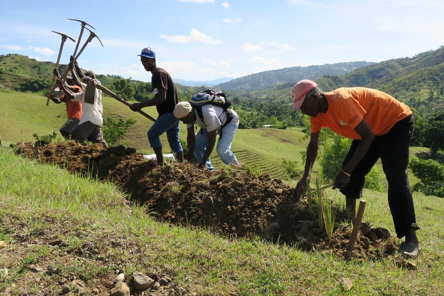
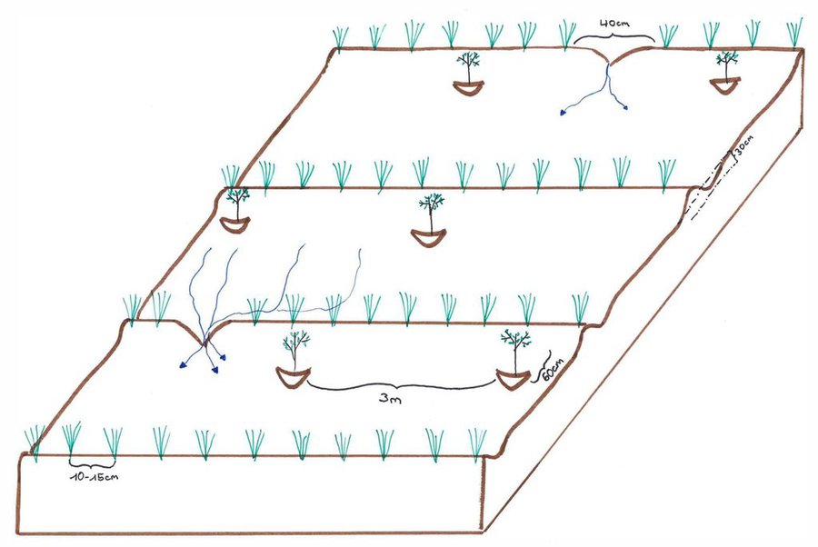
In a third step, channels (about 30cm deep) are dug following the picketed contour lines. The material removed is used to form ridges downstream of the channels. On the ridges, vetiver cuttings are planted every 10-15cm.
Author: Joana Eichenberger
It is recommended to leave a space of approx. 40cm in each line (see drawing). These spaces a) facilitate the passage for the land users once the vetiver grass is high and b) make it possible for extra water to escape (if there is too much water accumulated in the channels, the ridgesmay break). 60cm downstream of the vetiver hedges, fruit or forest tree seedlings are planted every 3m. After about three months, the roots of the vetivers are deep enough. Depending on the soil degradation’s degree, land users may begin to cultivate the spaces between the lines.
Author: Joana Eichenberger

Establishment and maintenance: activities, inputs and costs

Calculation of inputs and costs
  • Costs are calculated: per Technology unit (unit: Vetiver line volume, length: 200m)
  • Currency used for cost calculation: HTG
  • Exchange rate (to USD): 1 USD = 62.0 HTG
  • Average wage cost of hired labour per day: 200 HTG per person and day
Most important factors affecting the costs
1) Skilled labourers 2) Maintenance costs depends very much on the weather: if it rains too much, runoff destroys the ridges by forming gullies and removing the vetiver cuttings which were not sufficiently rooted. If it does not rain enough during the first weeks, the vetivers can not form roots, dry out and must be replaced.
Establishment activities
  1. If necessary: deforest the plot (Timing/ frequency: None)
  2. Measure the slope with A-level and calculate the necessary distance between the lines of vetiver (Timing/ frequency: None)
  3. Mark out the contour lines (put a stake every 3m) (Timing/ frequency: Beginning of the rainy season so that the vetiver can grow well -> March / April)
  4. Dig a channel following marked contour lines (Timing/ frequency: March / April)
  5. Plant the vetiver seedlings every 10-15cm on the ridges of soil below(downstream) the canal (Timing/ frequency: March / April)
  6. Plant the tree seedlings every 3m below (downstream) the vetiver lines (Timing/ frequency: March / April)
Establishment inputs and costs (per Vetiver line)
Specify input Unit Quantity Costs per Unit (HTG) Total costs per input (HTG) % of costs borne by land users
Labour
Unskilled labourer person-days 20.0 200.0 4000.0 100.0
Skilled labourer person-days 5.0 1000.0 5000.0
Equipment
Machete pieces 1.0 5.0 5.0 100.0
Pickaxe pieces 3.0 5.0 15.0 100.0
A-level pieces 1.0 5.0 5.0 100.0
Hoe pieces 5.0 5.0 25.0 100.0
Plant material
Vetiver grass cuttings 2000.0 2.0 4000.0
Trees cuttings 67.0 50.0 3350.0
Total costs for establishment of the Technology 16'400.0
Total costs for establishment of the Technology in USD 264.52
Maintenance activities
  1. Replant dead cuttings (Timing/ frequency: 2 times a year)
  2. Reparing broken ridges (Timing/ frequency: 2 times a year)
  3. Verify if ridges are ok (Timing/ frequency: In the beginning once a month, after that only once every three months)
  4. Cultivate normally (Timing/ frequency: From tree months after implementation)
Maintenance inputs and costs (per Vetiver line)
Specify input Unit Quantity Costs per Unit (HTG) Total costs per input (HTG) % of costs borne by land users
Labour
Land user and his family (monthly check, 1/2 day of work for 200m) person-days 6.0 200.0 1200.0 100.0
Replanting dead cuttings and reparing ridges (2 times a year total 5 working days for 20 people) person-days 100.0 200.0 20000.0 100.0
Equipment
Hoe pieces 1.0 5.0 5.0 100.0
Plant material
Vetiver cuttings replaced after rainy season (5%) cuttings 65.0 2.0 130.0
Vetiver cuttings replaced after dry period (40%) cuttings 533.0 2.0 1066.0
Total costs for maintenance of the Technology 22'401.0
Total costs for maintenance of the Technology in USD 361.31

Natural environment

Average annual rainfall
  • < 250 mm
  • 251-500 mm
  • 501-750 mm
  • 751-1,000 mm
  • 1,001-1,500 mm
  • 1,501-2,000 mm
  • 2,001-3,000 mm
  • 3,001-4,000 mm
  • > 4,000 mm
Agro-climatic zone
  • humid
  • sub-humid
  • semi-arid
  • arid
Specifications on climate
The windward sides (north-facing slopes) receive more rain than the leeward sides.

Léogâne has a tropical climate with a rainy season ranging from April to November (with two peaks in April-May and August-October) and a dry season from the end of November to March. The relative decrease in rainfall in June and July is called the "mid-summer drought". Due to climate change, the rainy season tends to start later than it used to.
Mean annual temperature: 25-27°C
Slope
  • flat (0-2%)
  • gentle (3-5%)
  • moderate (6-10%)
  • rolling (11-15%)
  • hilly (16-30%)
  • steep (31-60%)
  • very steep (>60%)
Landforms
  • plateau/plains
  • ridges
  • mountain slopes
  • hill slopes
  • footslopes
  • valley floors
Altitude
  • 0-100 m a.s.l.
  • 101-500 m a.s.l.
  • 501-1,000 m a.s.l.
  • 1,001-1,500 m a.s.l.
  • 1,501-2,000 m a.s.l.
  • 2,001-2,500 m a.s.l.
  • 2,501-3,000 m a.s.l.
  • 3,001-4,000 m a.s.l.
  • > 4,000 m a.s.l.
Technology is applied in
  • convex situations
  • concave situations
  • not relevant
Soil depth
  • very shallow (0-20 cm)
  • shallow (21-50 cm)
  • moderately deep (51-80 cm)
  • deep (81-120 cm)
  • very deep (> 120 cm)
Soil texture (topsoil)
  • coarse/ light (sandy)
  • medium (loamy, silty)
  • fine/ heavy (clay)
Soil texture (> 20 cm below surface)
  • coarse/ light (sandy)
  • medium (loamy, silty)
  • fine/ heavy (clay)
Topsoil organic matter content
  • high (>3%)
  • medium (1-3%)
  • low (<1%)
Groundwater table
  • on surface
  • < 5 m
  • 5-50 m
  • > 50 m
Availability of surface water
  • excess
  • good
  • medium
  • poor/ none
Water quality (untreated)
  • good drinking water
  • poor drinking water (treatment required)
  • for agricultural use only (irrigation)
  • unusable
Water quality refers to:
Is salinity a problem?
  • Ja
  • Nee

Occurrence of flooding
  • Ja
  • Nee
Species diversity
  • high
  • medium
  • low
Habitat diversity
  • high
  • medium
  • low

Characteristics of land users applying the Technology

Market orientation
  • subsistence (self-supply)
  • mixed (subsistence/ commercial)
  • commercial/ market
Off-farm income
  • less than 10% of all income
  • 10-50% of all income
  • > 50% of all income
Relative level of wealth
  • very poor
  • poor
  • average
  • rich
  • very rich
Level of mechanization
  • manual work
  • animal traction
  • mechanized/ motorized
Sedentary or nomadic
  • Sedentary
  • Semi-nomadic
  • Nomadic
Individuals or groups
  • individual/ household
  • groups/ community
  • cooperative
  • employee (company, government)
Gender
  • women
  • men
Age
  • children
  • youth
  • middle-aged
  • elderly
Area used per household
  • < 0.5 ha
  • 0.5-1 ha
  • 1-2 ha
  • 2-5 ha
  • 5-15 ha
  • 15-50 ha
  • 50-100 ha
  • 100-500 ha
  • 500-1,000 ha
  • 1,000-10,000 ha
  • > 10,000 ha
Scale
  • small-scale
  • medium-scale
  • large-scale
Land ownership
  • state
  • company
  • communal/ village
  • group
  • individual, not titled
  • individual, titled
Land use rights
  • open access (unorganized)
  • communal (organized)
  • leased
  • individual
Water use rights
  • open access (unorganized)
  • communal (organized)
  • leased
  • individual
Access to services and infrastructure
health

poor
good
education

poor
good
technical assistance

poor
good
employment (e.g. off-farm)

poor
good
markets

poor
good
energy

poor
good
roads and transport

poor
good
drinking water and sanitation

poor
good
financial services

poor
good

Impacts

Socio-economic impacts
Crop production
decreased
increased


When established on very degraded land, land users have to patient and wait the soil to recover. But in the long run agricultural production will increase.

crop quality
decreased
increased


When established on very degraded land, land users have to patient and wait the soil to recover. But in the long run crop quality will increase.

risk of production failure
increased
decreased

product diversity
decreased
increased

production area (new land under cultivation/ use)
decreased
increased

drinking water availability
decreased
increased

farm income
decreased
increased


When established on very degraded land, land users have to patient and wait the soil to recover. But in the long run farm income will increase.

Socio-cultural impacts
food security/ self-sufficiency
reduced
improved


When established on very degraded land, land users have to patient and wait the soil to recover. But in the long run food security will increase.

SLM/ land degradation knowledge
reduced
improved

Ecological impacts
water quantity
decreased
increased

water quality
decreased
increased

surface runoff
increased
decreased

evaporation
increased
decreased

soil moisture
decreased
increased

soil cover
reduced
improved

soil loss
increased
decreased

soil accumulation
decreased
increased

soil crusting/ sealing
increased
reduced

vegetation cover
decreased
increased

flood impacts
increased
decreased

landslides/ debris flows
increased
decreased

drought impacts
increased
decreased

impacts of cyclones, rain storms
increased
decreased

emission of carbon and greenhouse gases
increased
decreased

micro-climate
worsened
improved

Off-site impacts
water availability (groundwater, springs)
decreased
increased

reliable and stable stream flows in dry season (incl. low flows)
reduced
increased

downstream flooding (undesired)
increased
reduced

downstream siltation
increased
decreased

damage on neighbours' fields
increased
reduced

damage on public/ private infrastructure
increased
reduced

Cost-benefit analysis

Benefits compared with establishment costs
Short-term returns
very negative
very positive

Long-term returns
very negative
very positive

Benefits compared with maintenance costs
Short-term returns
very negative
very positive

Long-term returns
very negative
very positive

When established on very degraded land, it is necessary to wait a few months / years until land users can enjoy the benefits of this technology.

Climate change

Climate-related extremes (disasters)
tropical storm

not well at all
very well
local rainstorm

not well at all
very well
drought

not well at all
very well
landslide

not well at all
very well

Adoption and adaptation

Percentage of land users in the area who have adopted the Technology
  • single cases/ experimental
  • 1-10%
  • 11-50%
  • > 50%
Of all those who have adopted the Technology, how many have done so without receiving material incentives?
  • 0-10%
  • 11-50%
  • 51-90%
  • 91-100%
Has the Technology been modified recently to adapt to changing conditions?
  • Ja
  • Nee
To which changing conditions?
  • climatic change/ extremes
  • changing markets
  • labour availability (e.g. due to migration)
  • Terrain conditions
The Swiss Red Cross has tried out this technology by using sugar cane instead of vetiver. But since vetiver has deeper roots and is more resistant to dry periods, the SRC abandoned the variation with sugar cane. If the ground is too degraded it is not necessary to make long lines of vetiver with always the same distance between one and the other (see the photo under description). We must adapt to the terrain.

Conclusions and lessons learnt

Strengths: land user's view
  • vegetable matter for mulching
  • sediment retention
  • increased soil moisture
Strengths: compiler’s or other key resource person’s view
  • smoothens the slope
  • recuces soil erosion
  • improves soil fertility
Weaknesses/ disadvantages/ risks: land user's viewhow to overcome
  • Land users believe this technology recuces the arable surface. It is necessary to increase the land users awareness regarding the benefits of the technology, like for example the productivity which increases.
  • The implementation of the technology is very labour-intensive. Show that other technologies give even more work (e.g. progressive terraces with dry stones)
Weaknesses/ disadvantages/ risks: compiler’s or other key resource person’s viewhow to overcome
  • The technique with vetiver grass depends on rain and as a result it is more vulnerable than dry stone technology. The dry stone technology is only applied where there are stones locally available. Otherwise buying the stones and transporting them would cost too much.

References

Compiler
  • Joana Eichenberger
Editors
  • Hanspeter Liniger
  • Jean Carls Dessin
Reviewer
  • Hanspeter Liniger
Date of documentation: Okt. 19, 2017
Last update: Junie 27, 2021
Resource persons
Full description in the WOCAT database
Linked SLM data
Documentation was faciliated by
Institution Project
Key references
  • Policy Brief: Productive and protective land management – reducing disastrous floods and saving springs in Haiti Author: Eichenberger J, Liniger HP, Year: 2020: https://www.wocat.net/en/projects-and-countries/projects/onsite-and-offsite-benefits-sustainable-land-management/haiti
  • Video: Productive and protective land management – reducing disastrous floods and saving springs in Haiti Author: Liniger HP, Eichenberger J, Year: 2020: https://vimeo.com/429957516
This work is licensed under Creative Commons Attribution-NonCommercial-ShareaAlike 4.0 International