Vegetative riparian buffer (Brigitta Szabó)

Vegetative riparian buffers (Hungary)

Vízparti erdős puffersáv

Description

Vegetative riparian buffers are strips of trees, bushes and grass alongside surface water bodies such as streams or ponds. Their main function is to provide a natural buffer strip to filter out nutrient and sediment transported from agricultural fields and prevent it reaching the water bodies - as well as maintaining undisturbed green corridors.

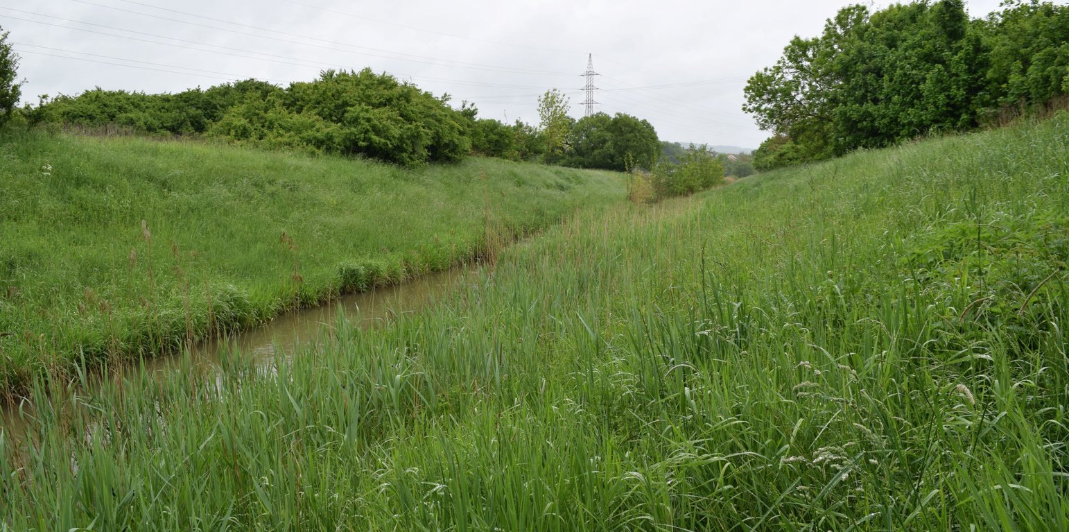
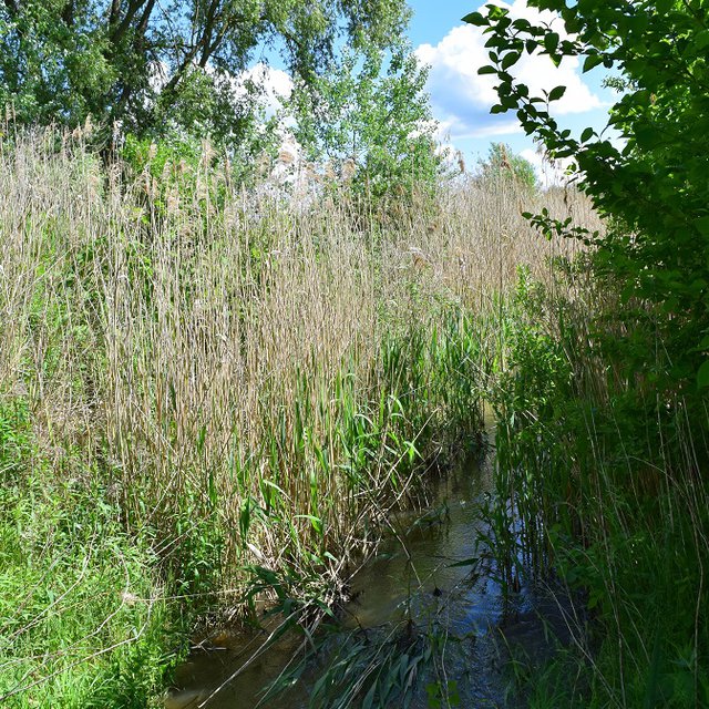
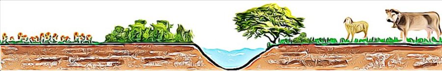
Vegetative riparian buffers are strips of trees and other vegetation alongside surface water bodies such as streams or ponds. They are used in natural environments, as well as in urban, agricultural and wetland areas. Their main function is to provide a natural buffer to increase infiltration, and to filter out nutrients and sediment transported from agricultural fields – thus preventing it reaching (and polluting) water bodies. Riparian buffers also help moderate flow. Creating such green corridors alongside waterlines is advantageous ecologically as well. However, land users usually prefer cultivating the largest possible area of land, so they dislike leaving significant areas abandoned to nature. Another complaint is that riparian buffers provide habitats for wildlife, often resulting in damage to cropland.

Where a natural buffer does not exist - mostly in the neighbourhood of agricultural fields - it can be created by planting trees and bushes alongside the water body. Variable buffer width design with an average width of 15 m (max. 20 m) is recommended.

Location

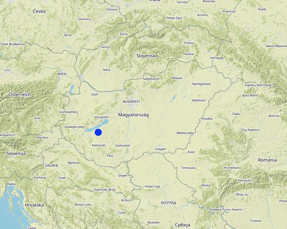
Location: The site where the technology is applied is situated within the catchment of Tetves stream, which belongs to the Balaton Catchment Area in the western Hungary. The climate is moderately warm, moderately humid, mean annual temperature is about 10 ˚C. The average amount of rainfall is between 600 and 700 mm / year., Somogy, Hungary

No. of Technology sites analysed: 2-10 sites

Geo-reference of selected sites
  • 17.77417, 46.69244

Spread of the Technology: applied at specific points/ concentrated on a small area

In a permanently protected area?: Nee

Date of implementation: 10-50 years ago

Type of introduction
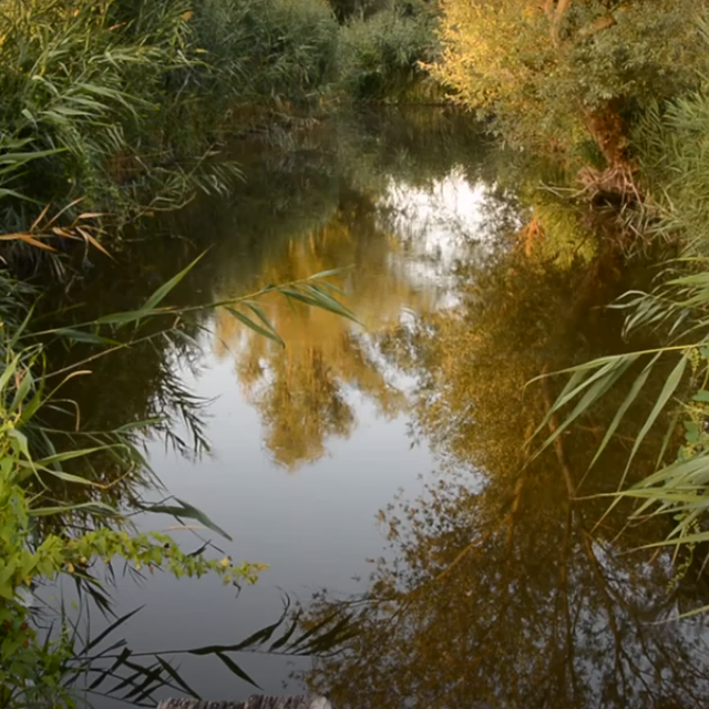
Vegetative riparian buffer (Piroska Kassai)
Riparian buffer (Brigitta Szabó)

Classification of the Technology

Main purpose
  • improve production
  • reduce, prevent, restore land degradation
  • conserve ecosystem
  • protect a watershed/ downstream areas – in combination with other Technologies
  • preserve/ improve biodiversity
  • reduce risk of disasters
  • adapt to climate change/ extremes and its impacts
  • mitigate climate change and its impacts
  • create beneficial economic impact
  • create beneficial social impact
Land use
Land use mixed within the same land unit: Nee

  • Cropland
    • Annual cropping: cereals - barley, cereals - maize, cereals - wheat (winter), oilseed crops - sunflower, rapeseed, other
    Number of growing seasons per year: 1
    Is intercropping practiced? Ja
    Is crop rotation practiced? Ja
  • Grazing land
    • Semi-nomadic pastoralism
    Animal type: cattle - dairy and beef (e.g. zebu)
  • Waterways, waterbodies, wetlands - Drainage lines, waterways

Water supply
  • rainfed
  • mixed rainfed-irrigated
  • full irrigation

Purpose related to land degradation
  • prevent land degradation
  • reduce land degradation
  • restore/ rehabilitate severely degraded land
  • adapt to land degradation
  • not applicable
Degradation addressed
  • soil erosion by water - Wr: riverbank erosion, Wo: offsite degradation effects
  • water degradation - Hp: decline of surface water quality, Hq: decline of groundwater quality
SLM group
  • natural and semi-natural forest management
  • forest plantation management
  • surface water management (spring, river, lakes, sea)
SLM measures
  • vegetative measures - V1: Tree and shrub cover

Technical drawing

Technical specifications
A variable buffer width design with a basic width of 15 m (max 20 m) is recommended.
Author: Piroska Kassai

Establishment and maintenance: activities, inputs and costs

Calculation of inputs and costs
  • Costs are calculated: per Technology area (size and area unit: hectare (20X500 m))
  • Currency used for cost calculation: USD
  • Exchange rate (to USD): 1 USD = n.a
  • Average wage cost of hired labour per day: 50
Most important factors affecting the costs
-
Establishment activities
  1. Soil preparation (Timing/ frequency: any season)
  2. Planting (Timing/ frequency: autumn)
Establishment inputs and costs (per hectare (20X500 m))
Specify input Unit Quantity Costs per Unit (USD) Total costs per input (USD) % of costs borne by land users
Labour
Soil preparation person-day 2.0 50.0 100.0 100.0
Planting (4000 seedlings on 1 hectare) person-day 3.0 50.0 150.0 100.0
Equipment
Soil preparation hiring cost/day 1.0 400.0 400.0 100.0
Planting hiring cost/day 1.0 100.0 100.0 100.0
Plant material
Seedlings piece 4000.0 0.1 400.0 100.0
Total costs for establishment of the Technology 1'150.0
Total costs for establishment of the Technology in USD 1'150.0
Maintenance activities
  1. No maintenance required (Timing/ frequency: None)
Maintenance inputs and costs (per hectare (20X500 m))
Specify input Unit Quantity Costs per Unit (USD) Total costs per input (USD) % of costs borne by land users
Labour
No maintenance required

Natural environment

Average annual rainfall
  • < 250 mm
  • 251-500 mm
  • 501-750 mm
  • 751-1,000 mm
  • 1,001-1,500 mm
  • 1,501-2,000 mm
  • 2,001-3,000 mm
  • 3,001-4,000 mm
  • > 4,000 mm
Agro-climatic zone
  • humid
  • sub-humid
  • semi-arid
  • arid
Specifications on climate
Average annual rainfall in mm: 653.0
the distribution of the precipitation is uneven
Name of the meteorological station: Keszthely meteorological station
Slope
  • flat (0-2%)
  • gentle (3-5%)
  • moderate (6-10%)
  • rolling (11-15%)
  • hilly (16-30%)
  • steep (31-60%)
  • very steep (>60%)
Landforms
  • plateau/plains
  • ridges
  • mountain slopes
  • hill slopes
  • footslopes
  • valley floors
Altitude
  • 0-100 m a.s.l.
  • 101-500 m a.s.l.
  • 501-1,000 m a.s.l.
  • 1,001-1,500 m a.s.l.
  • 1,501-2,000 m a.s.l.
  • 2,001-2,500 m a.s.l.
  • 2,501-3,000 m a.s.l.
  • 3,001-4,000 m a.s.l.
  • > 4,000 m a.s.l.
Technology is applied in
  • convex situations
  • concave situations
  • not relevant
Soil depth
  • very shallow (0-20 cm)
  • shallow (21-50 cm)
  • moderately deep (51-80 cm)
  • deep (81-120 cm)
  • very deep (> 120 cm)
Soil texture (topsoil)
  • coarse/ light (sandy)
  • medium (loamy, silty)
  • fine/ heavy (clay)
Soil texture (> 20 cm below surface)
  • coarse/ light (sandy)
  • medium (loamy, silty)
  • fine/ heavy (clay)
Topsoil organic matter content
  • high (>3%)
  • medium (1-3%)
  • low (<1%)
Groundwater table
  • on surface
  • < 5 m
  • 5-50 m
  • > 50 m
Availability of surface water
  • excess
  • good
  • medium
  • poor/ none
Water quality (untreated)
  • good drinking water
  • poor drinking water (treatment required)
  • for agricultural use only (irrigation)
  • unusable
Water quality refers to: surface water
Is salinity a problem?
  • Ja
  • Nee

Occurrence of flooding
  • Ja
  • Nee
Species diversity
  • high
  • medium
  • low
Habitat diversity
  • high
  • medium
  • low

Characteristics of land users applying the Technology

Market orientation
  • subsistence (self-supply)
  • mixed (subsistence/ commercial)
  • commercial/ market
Off-farm income
  • less than 10% of all income
  • 10-50% of all income
  • > 50% of all income
Relative level of wealth
  • very poor
  • poor
  • average
  • rich
  • very rich
Level of mechanization
  • manual work
  • animal traction
  • mechanized/ motorized
Sedentary or nomadic
  • Sedentary
  • Semi-nomadic
  • Nomadic
Individuals or groups
  • individual/ household
  • groups/ community
  • cooperative
  • employee (company, government)
Gender
  • women
  • men
Age
  • children
  • youth
  • middle-aged
  • elderly
Area used per household
  • < 0.5 ha
  • 0.5-1 ha
  • 1-2 ha
  • 2-5 ha
  • 5-15 ha
  • 15-50 ha
  • 50-100 ha
  • 100-500 ha
  • 500-1,000 ha
  • 1,000-10,000 ha
  • > 10,000 ha
Scale
  • small-scale
  • medium-scale
  • large-scale
Land ownership
  • state
  • company
  • communal/ village
  • group
  • individual, not titled
  • individual, titled
Land use rights
  • open access (unorganized)
  • communal (organized)
  • leased
  • individual
Water use rights
  • open access (unorganized)
  • communal (organized)
  • leased
  • individual
Access to services and infrastructure
health

poor
good
education

poor
good
technical assistance

poor
good
employment (e.g. off-farm)

poor
good
markets

poor
good
energy

poor
good
roads and transport

poor
good
drinking water and sanitation

poor
good
financial services

poor
good

Impacts

Socio-economic impacts
Crop production
decreased
increased


Crop production will decrease slightly because the cultivated area will be less, but it is not significant from an economic point of view.

production area (new land under cultivation/ use)
decreased
increased

Socio-cultural impacts
Ecological impacts
water quality
decreased
increased


Both on-site and off-site positive effect can be observed because the inflow waters (e.g Tetves) quality can help to protect Lake Balaton from eutrophication.

soil loss
increased
decreased

vegetation cover
decreased
increased


Riparian buffers are permanent vegetation covers.

habitat diversity
decreased
increased


It provides a wildlife habitat and corridors for terrestrial organisms

Off-site impacts
groundwater/ river pollution
increased
reduced

buffering/ filtering capacity (by soil, vegetation, wetlands)
reduced
improved


It can filter nutrients, pesticides, and animal waste from agricultural land runoff

Cost-benefit analysis

Benefits compared with establishment costs
Short-term returns
very negative
very positive

Long-term returns
very negative
very positive

Benefits compared with maintenance costs
Short-term returns
very negative
very positive

Long-term returns
very negative
very positive

Climate change

Gradual climate change
annual temperature increase

not well at all
very well
seasonal rainfall decrease

not well at all
very well
Season: summer
Climate-related extremes (disasters)
landslide

not well at all
very well

Adoption and adaptation

Percentage of land users in the area who have adopted the Technology
  • single cases/ experimental
  • 1-10%
  • 11-50%
  • > 50%
Of all those who have adopted the Technology, how many have done so without receiving material incentives?
  • 0-10%
  • 11-50%
  • 51-90%
  • 91-100%
Has the Technology been modified recently to adapt to changing conditions?
  • Ja
  • Nee
To which changing conditions?
  • climatic change/ extremes
  • changing markets
  • labour availability (e.g. due to migration)

Conclusions and lessons learnt

Strengths: land user's view
  • Soil erosion/sediment control
Strengths: compiler’s or other key resource person’s view
  • Trees in riparian areas can efficiently take up excess nutrients
  • It can decrease sediment inputs to surface waters
  • It can create riparian habitat
Weaknesses/ disadvantages/ risks: land user's viewhow to overcome
  • It overshadows the edge of the neighboring parcel and decrease the yield
  • Wild animals living there can cause damages on croplands
  • Can cause the spread of weeds on the neighboring parcels
Weaknesses/ disadvantages/ risks: compiler’s or other key resource person’s viewhow to overcome
  • Conflicts can occur between the water managment authority and farmers regarding the border of the cultivated area

References

Compiler
  • Brigitta Szabó
Editors
  • Piroska Kassai
  • Zoltan Toth
Reviewer
  • William Critchley
  • Rima Mekdaschi Studer
Date of documentation: Maart 29, 2022
Last update: Maart 28, 2023
Resource persons
Full description in the WOCAT database
Linked SLM data
Documentation was faciliated by
Institution Project
Key references
  • Jiang et al. 2020: Riparian buffer effectiveness as a function of buffer design and input loads: https://acsess.onlinelibrary.wiley.com/doi/10.1002/jeq2.20149
Links to relevant information which is available online
This work is licensed under Creative Commons Attribution-NonCommercial-ShareaAlike 4.0 International