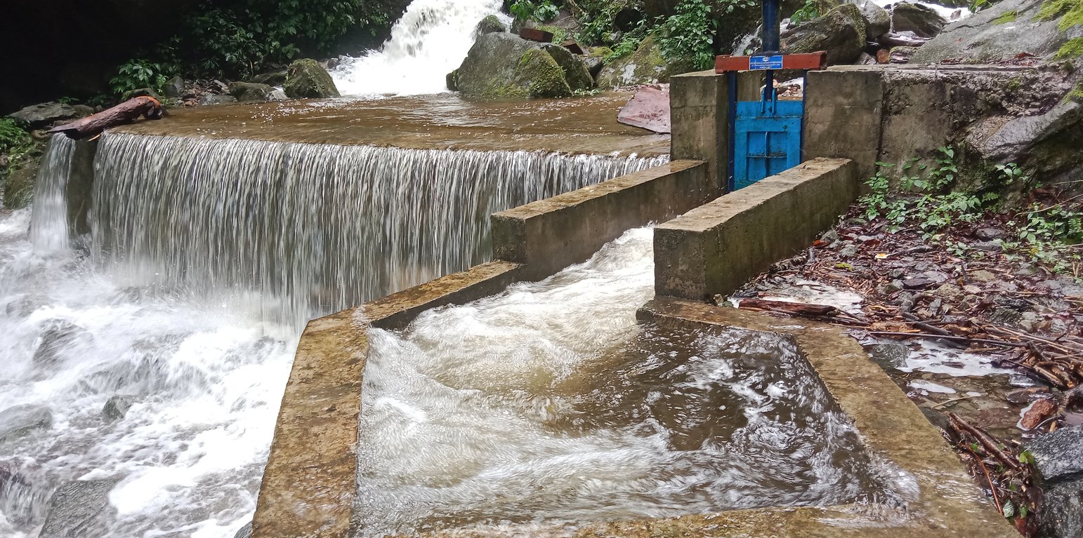
Climate Resilient Irrigation Scheme (sluice gate of the irrigation system) (Kuenzang Nima)

Climate Resilient Irrigation Scheme (Bhutan)

Nam Shi Thub Pai Zhing Chhu Yu Wa (གནམ་གཤིས་ཐུབ་པའི་ཞིང་ཆུ་གཡུར་བ།)

Description

A climate-resilient irrigation scheme is one that aims to successfully cope with and manage the impacts of climate change while preventing those impacts on the scheme from growing worse. The pipes are retrofitted with new and climate-resilient technology. Such a climate-proof irrigation system is designed to better withstand extreme weather conditions.

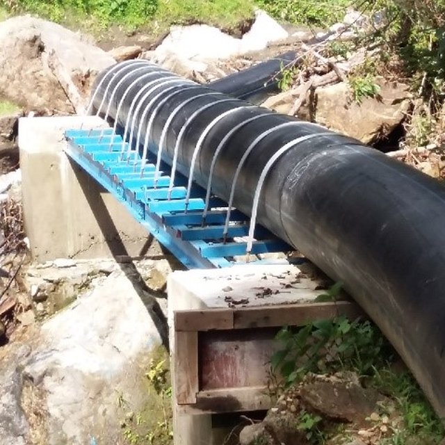
The climate-resilient irrigation scheme in Khomshar Chiwog under Bardho Gewog (Block), Zhemgang Dzongkhag (District), was funded by the Green Climate Fund (GCF), UNDP-Bhutan. The 3.9 km irrigation system was designed with a high-density polyethylene (HDPE) pipe system benefiting 150 households with a command area of 955 acres (approx. 386 ha). The total irrigation cost incurred was Nu. 18,055,180 (approx. USD 225,700) and was completed in 11 months (7 December 2020 - 7 November 2021). The irrigation scheme was officially handed over to the community on 27 August 2021, upon the formation of a water-user group (WUG).
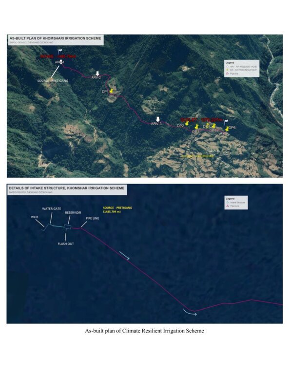
The smart irrigation system consists of key components, viz. intake, sluice gate, silt-cum-inlet tank, flush-out valves, air release valve, water distribution points, and tail point. The intake collects and diverts the water from the source to the sluice gate. The land users were taught to maintain the intake by regularly clearing it from bushes and removing debris. The sluice gate controls the flow of the water into the tank based on the water requirement. The silt-cum-inlet tank holds the water to settle out sediments and debris before clean water flows through the pipe at a constant rate. Flush out valves clear the sediment and debris from the tank. The air release valve vents out the air trapped in the pipe and water distribution points. Water distribution points deliver water to the users, as required, up to the tail point where water is discharged.
The irrigation scheme fulfils the need for a continuous water supply for both drinking and irrigation purposes. To ensure sustainability, a WUG headed by a chairman, a secretary, and a treasurer was instituted. The WUG ensures operations, maintenance, and harmonious distribution of water. The group is also responsible for the safety of the irrigation system.
The main reason for considering such irrigation scheme as being “climate resilient” is that unlike open earthen channels, this type of irrigation scheme results in zero loss of water through evaporation and leakage, as it is a closed channel. Furthermore, being closed, it is not prone to blockages caused by landslides triggered by rainfall. There is also complete end-to-end management, i.e., management at source including the watershed, and management at tail-end.
The irrigation scheme was constructed by a private company through a contract award: community members were not involved. The irrigation scheme was also accompanied by a land development programme (bench terracing) by a separate contractor, with the prospect of transitioning to irrigated paddy cultivation in the future after adequate soil stabilization. More than 90 acres (36 ha) of fallow lands were revived. This blended approach was applied to ensure the food self-security/sufficiency of the beneficiaries.
Though at a very initial stage, the construction and operation of the irrigation scheme have brought happiness to the beneficiaries. They expressed their hope and expectation of improved crop production, stable and reliable water availability, and major fallow land reversion.

Location

Location: Khomshar Chiwog, Bardho Gewog, Zhemgang Dzongkhag, Bhutan

No. of Technology sites analysed: single site

Geo-reference of selected sites
  • 90.94878, 27.1353

Spread of the Technology: applied at specific points/ concentrated on a small area

In a permanently protected area?: Nee

Date of implementation: 2021

Type of introduction
Climate Resilient Irrigation Scheme (sluice gate) (Kuenzang Nima)
High-density polyethylene (HDPE) pipe (Kuenzang Nima)

Classification of the Technology

Main purpose
  • improve production
  • reduce, prevent, restore land degradation
  • conserve ecosystem
  • protect a watershed/ downstream areas – in combination with other Technologies
  • preserve/ improve biodiversity
  • reduce risk of disasters
  • adapt to climate change/ extremes and its impacts
  • mitigate climate change and its impacts
  • create beneficial economic impact
  • create beneficial social impact
Land use
Land use mixed within the same land unit: Ja - Agroforestry

  • Cropland
    • Annual cropping: cereals - maize, cereals - rice (wetland)
    • Perennial (non-woody) cropping: banana/plantain/abaca, herbs, chili, capsicum
    • Tree and shrub cropping: avocado
    Number of growing seasons per year: 2
    Is intercropping practiced? Nee
    Is crop rotation practiced? Nee
  • Forest/ woodlands
    • (Semi-)natural forests/ woodlands. Management: Selective felling, Non-wood forest use
    Tree types (mixed deciduous/ evergreen): n.a.
    Products and services: Timber, Fuelwood, Grazing/ browsing

Water supply
  • rainfed
  • mixed rainfed-irrigated
  • full irrigation

Purpose related to land degradation
  • prevent land degradation
  • reduce land degradation
  • restore/ rehabilitate severely degraded land
  • adapt to land degradation
  • not applicable
Degradation addressed
  • water degradation - Hs: change in quantity of surface water, Hp: decline of surface water quality
SLM group
  • irrigation management (incl. water supply, drainage)
SLM measures
  • structural measures - S7: Water harvesting/ supply/ irrigation equipment

Technical drawing

Technical specifications
Source: https://www.bhutangcf.gov.bt/wp-content/uploads/2022/06/Khomshar-WUA_Training-Report.pdf

Establishment and maintenance: activities, inputs and costs

Calculation of inputs and costs
  • Costs are calculated: per Technology unit (unit: Irrigation line volume, length: Irrigation line: 3.9 km)
  • Currency used for cost calculation: Nu.
  • Exchange rate (to USD): 1 USD = 80.0 Nu.
  • Average wage cost of hired labour per day: n.a
Most important factors affecting the costs
n.a.
Establishment activities
n.a.
Total establishment costs (estimation)
18055180.0
Maintenance activities
  1. Replacement of pipe (Timing/ frequency: One time (just after the completion))
Total maintenance costs (estimation)
48000.0

Natural environment

Average annual rainfall
  • < 250 mm
  • 251-500 mm
  • 501-750 mm
  • 751-1,000 mm
  • 1,001-1,500 mm
  • 1,501-2,000 mm
  • 2,001-3,000 mm
  • 3,001-4,000 mm
  • > 4,000 mm
Agro-climatic zone
  • humid
  • sub-humid
  • semi-arid
  • arid
Specifications on climate
Annual rainfall: 1200-1800 mm
The rain estimate has been derived based on the agro-ecological zone (AEZ) the area falls under. Bhutan is divided into six AEZs (source: https://www.fao.org/3/ad103e/AD103E02.htm).
Bhutan has six AEZs. The wet sub-tropical zone is from 150 to 600 m, followed by the humid sub-tropical zone from 600 to 1,200 m. The dry sub-tropical zone starts at 1,200 m and extends to 1,800 m, followed by the warm temperate zone, which reaches 2,600 m. The cool temperate zone lies between 2,600 and 3,600 m and, finally, the alpine zone between 3,600 m and 4,600 m.
Dry Sub-tropical Zone in Bhutan
Slope
  • flat (0-2%)
  • gentle (3-5%)
  • moderate (6-10%)
  • rolling (11-15%)
  • hilly (16-30%)
  • steep (31-60%)
  • very steep (>60%)
Landforms
  • plateau/plains
  • ridges
  • mountain slopes
  • hill slopes
  • footslopes
  • valley floors
Altitude
  • 0-100 m a.s.l.
  • 101-500 m a.s.l.
  • 501-1,000 m a.s.l.
  • 1,001-1,500 m a.s.l.
  • 1,501-2,000 m a.s.l.
  • 2,001-2,500 m a.s.l.
  • 2,501-3,000 m a.s.l.
  • 3,001-4,000 m a.s.l.
  • > 4,000 m a.s.l.
Technology is applied in
  • convex situations
  • concave situations
  • not relevant
Soil depth
  • very shallow (0-20 cm)
  • shallow (21-50 cm)
  • moderately deep (51-80 cm)
  • deep (81-120 cm)
  • very deep (> 120 cm)
Soil texture (topsoil)
  • coarse/ light (sandy)
  • medium (loamy, silty)
  • fine/ heavy (clay)
Soil texture (> 20 cm below surface)
  • coarse/ light (sandy)
  • medium (loamy, silty)
  • fine/ heavy (clay)
Topsoil organic matter content
  • high (>3%)
  • medium (1-3%)
  • low (<1%)
Groundwater table
  • on surface
  • < 5 m
  • 5-50 m
  • > 50 m
Availability of surface water
  • excess
  • good
  • medium
  • poor/ none
Water quality (untreated)
  • good drinking water
  • poor drinking water (treatment required)
  • for agricultural use only (irrigation)
  • unusable
Water quality refers to: surface water
Is salinity a problem?
  • Ja
  • Nee

Occurrence of flooding
  • Ja
  • Nee
Species diversity
  • high
  • medium
  • low
Habitat diversity
  • high
  • medium
  • low

Characteristics of land users applying the Technology

Market orientation
  • subsistence (self-supply)
  • mixed (subsistence/ commercial)
  • commercial/ market
Off-farm income
  • less than 10% of all income
  • 10-50% of all income
  • > 50% of all income
Relative level of wealth
  • very poor
  • poor
  • average
  • rich
  • very rich
Level of mechanization
  • manual work
  • animal traction
  • mechanized/ motorized
Sedentary or nomadic
  • Sedentary
  • Semi-nomadic
  • Nomadic
Individuals or groups
  • individual/ household
  • groups/ community
  • cooperative
  • employee (company, government)
Gender
  • women
  • men
Age
  • children
  • youth
  • middle-aged
  • elderly
Area used per household
  • < 0.5 ha
  • 0.5-1 ha
  • 1-2 ha
  • 2-5 ha
  • 5-15 ha
  • 15-50 ha
  • 50-100 ha
  • 100-500 ha
  • 500-1,000 ha
  • 1,000-10,000 ha
  • > 10,000 ha
Scale
  • small-scale
  • medium-scale
  • large-scale
Land ownership
  • state
  • company
  • communal/ village
  • group
  • individual, not titled
  • individual, titled
  • Family land
Land use rights
  • open access (unorganized)
  • communal (organized)
  • leased
  • individual
Water use rights
  • open access (unorganized)
  • communal (organized)
  • leased
  • individual
Access to services and infrastructure
health

poor
good
education

poor
good
technical assistance

poor
good
employment (e.g. off-farm)

poor
good
markets

poor
good
energy

poor
good
roads and transport

poor
good
drinking water and sanitation

poor
good
financial services

poor
good

Impacts

Socio-economic impacts
Crop production
decreased
increased

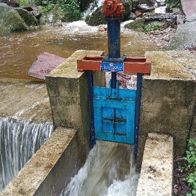
Quantity before SLM: 250-300 Drey from one acre paddy land
Quantity after SLM: 600-700 Drey from one acre
The old conventional irrigation channel used to suffer multiple breakdowns quite often. Due to this most of the paddy fields were left fallow (30%) because of insufficient irrigation water. Currently, all the wetlands (100%) are brought under cultivation. Hence, the production has been enhanced.
Note: Drey is a traditional grain measuring container. One Drey is about 1.5 kg.

crop quality
decreased
increased


The paddy harvest appears to be of better quality when there is enough irrigation. Otherwise, the growths are hampered, resulting in higher vegetative growths only.

fodder production
decreased
increased


The higher hay production (by-product) has been beneficial for farmers to feed livestock.

animal production
decreased
increased


Safe and readily available water to feed the livestock, facilitated by the irrigation scheme has enhanced animal production. Earlier, the farmers used to depend on the far-flung streams/ponds.

land management
hindered
simplified


Better access to irrigation water has motivated farmers to adopt land development. Hence, about 90 acres of fallow lands in the community have been revived through new terrace constructions.

drinking water availability
decreased
increased


The irrigation water is being used for drinking purposes too. The drinking water quantity has been enhanced. Earlier, the drinking water source was not enough to meet the requirements due to higher households, especially in winter.

drinking water quality
decreased
increased


The drinking water tapped from this irrigation is clean and hygienic, unlike before.

water availability for livestock
decreased
increased

water quality for livestock
decreased
increased

irrigation water availability
decreased
increased

irrigation water quality
decreased
increased

demand for irrigation water
increased
decreased


Due to new terrace construction, the demand for irrigation water has increased.

expenses on agricultural inputs
increased
decreased


One acre of paddy cultivation used to take 4-5 days. Now, one acre takes 1 day. Mechanization is enhanced.

farm income
decreased
increased


Currently, the impact is at the initial stage (1 year). The income could quantified in the later years.

Socio-cultural impacts
cultural opportunities (eg spiritual, aesthetic, others)
reduced
improved


Irrigation and land development interventions have beautified the community (aesthetic). The external visitors are astonished.

SLM/ land degradation knowledge
reduced
improved

conflict mitigation
worsened
improved


Community dispute over water demand and mid night water guarding during paddy cultivation due to water scarcity used to be rampant before.

situation of socially and economically disadvantaged groups (gender, age, status, ehtnicity etc.)
worsened
improved

Ecological impacts
water quantity
decreased
increased

water quality
decreased
increased

soil moisture
decreased
increased

biomass/ above ground C
decreased
increased

flood impacts
increased
decreased


The conventional irrigation channel used to result in water seepage and accumulation of groundwater, leading to flooding of underneath fields. Now, this pipe irrigation has been solved and flooding is not evident.

landslides/ debris flows
increased
decreased


Due to improper irrigation source management before, the water outflow was used to wash away a huge portion of lands and roads below. Due to enhanced source protection, this issue is solved.

Off-site impacts

Cost-benefit analysis

Benefits compared with establishment costs
Short-term returns
very negative
very positive

Long-term returns
very negative
very positive

Benefits compared with maintenance costs
Short-term returns
very negative
very positive

Long-term returns
very negative
very positive

Climate change

Gradual climate change
annual temperature increase

not well at all
very well
annual rainfall increase

not well at all
very well
Climate-related extremes (disasters)
local rainstorm

not well at all
very well
local thunderstorm

not well at all
very well
local windstorm

not well at all
very well
extreme winter conditions

not well at all
very well
landslide

not well at all
very well

Adoption and adaptation

Percentage of land users in the area who have adopted the Technology
  • single cases/ experimental
  • 1-10%
  • 11-50%
  • > 50%
Of all those who have adopted the Technology, how many have done so without receiving material incentives?
  • 0-10%
  • 11-50%
  • 51-90%
  • 91-100%
Number of households and/ or area covered
150
Has the Technology been modified recently to adapt to changing conditions?
  • Ja
  • Nee
To which changing conditions?
  • climatic change/ extremes
  • changing markets
  • labour availability (e.g. due to migration)

Conclusions and lessons learnt

Strengths: land user's view
  • Enough irrigation and drinking water compared to earlier conventional system.
  • Fallow land reversion is being enhanced.
  • Cleanliness (social hygiene) due to better water availability.
Strengths: compiler’s or other key resource person’s view
  • Fallow land reversion is being enhanced.
Weaknesses/ disadvantages/ risks: land user's viewhow to overcome
  • Risk of source destruction due to landslide. Shifting the current source tank to a different location.
  • No proper filtration at the source. Currently, a locally fabricated filter is being used. Permanent filter is required.
Weaknesses/ disadvantages/ risks: compiler’s or other key resource person’s viewhow to overcome
  • The road leading to source, constructed exclusively to monitor the irrigation line is not being maintained well. Timely road maintenance by the beneficiaries.
  • The source tank premise needs proper fencing to avoid casualties. Fencing the irrigation source premises.

References

Compiler
  • Tshering Yangzom
Editors
  • chenga Tshering
Reviewer
  • William Critchley
  • Rima Mekdaschi Studer
  • Joana Eichenberger
Date of documentation: Julie 12, 2023
Last update: Junie 4, 2024
Resource persons
Full description in the WOCAT database
Linked SLM data
Documentation was faciliated by
Institution Project
Links to relevant information which is available online
This work is licensed under Creative Commons Attribution-NonCommercial-ShareaAlike 4.0 International