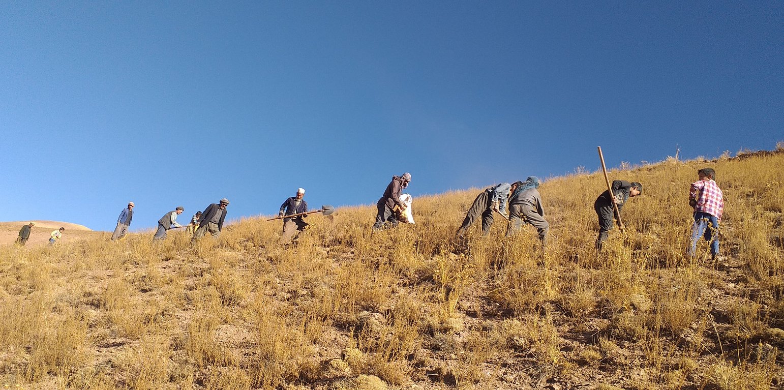
Members of the Rangeland Management Association actively engaged in reseeding local fodder species to restore and sustain the rangeland ecosystem. (Gul Nabi Khan)

Reseeding local fodder species in Bamyan rangelands using indigenous and scientific methods (Afghanistan)

کاشت انواع علوفه جات محلی در علفچرهای بامیان با استفاده از رویشهای های بومی و علمی

Description

Artificial reseeding is a key method for restoring degraded rangelands. It involves reintroducing native, palatable fodder species to improve vegetation cover, soil health, and biodiversity. This process boosts forage for grazing animals, stabilizes soil, and helps combat desertification, enhancing ecosystem health and productivity.

The Food and Agriculture Organization (FAO) project of “Community-based sustainable land and forest management in Afghanistan” aimed to conserve vegetation cover and ecosystems through introducing community-based sustainable land and forest management (SLM/SFM) practices in rangeland and forest areas within five targeted provinces, including Bamyan, that benefited rural communities that rely on these ecosystems for their livelihood. The project introduced an integrated, community-based approach of SLM/SFM in Afghanistan for promoting biodiversity conservation, climate change mitigation, and rangeland productivity.

To enhance rangeland productivity in Bamyan province, artificial reseeding of native, locally adapted, and drought-resistant fodder species plays a vital role in restoring health and productivity of the degraded rangeland ecosystem, improving soil quality, and increasing fodder availability for livestock, which contributed to local livelihoods and environmental resilience.

Communities carefully identify highly vulnerable and degraded rangelands for reseeding initiatives. These include previously rain-fed wheat fields cultivated for human consumption, overgrazed sites, and areas with restricted grazing to support vegetation recovery before reseeding. Attention is also given to areas prone to snow avalanches and flash floods causing landslides and soil erosion, which impact downstream residential areas, irrigation systems, trails, roads, and farmlands. These zones are prioritized and mutually agreed upon for reseeding and restoration efforts.

This reseeding local fodder species technology involves several key activities.

1.Identification of locally adapted drought-resistant and palatable fodder species by livestock owners and land users.
2.Identification of highly producing areas of selected fodder species to collect quality seeds.
3.Defer grazing and delay fodder harvest for the purpose of seed maturity in the targeted area.
4.Awareness raising about the maturity stages of different fodder species seeds: Through project intervention and awareness campaigns, rural residents have gained a better understanding of the seed ripening, collecting, and cultivation stages.
5.Collecting, drying, and storing seed: The fodder species’ seeds are collected manually by hand. These fodder species produce longer main stems with inflorescence and spikelets on the top at an average person's breast height. Collected seed is brought to the storing facility and laid out under sunlight for drying. Once seed reaches a certain moisture content, it's stored in a cool and dry place until the day of reseeding under the direct supervision of the rangeland management association (RMA).
6.Season of reseeding local fodder seed: Reseeding activities typically begin in the autumn season, just before the first snowfall. Seeds remain in the soil throughout the winter, allowing them to overcome dormancy and germinate in the spring of the following year. Local fodder species used for reseeding include various Fennel species and other plants traditionally relied upon for winter fodder. These include: Umbelliferae ferulus (Gheghu), Winklera silaifolia (Pali), Prangos sp. (Kami), Ferula sp. (Badran), Rheum spp. (Chukri), Koeleria cristata (Khola), a shrub locally known as Qarghna.
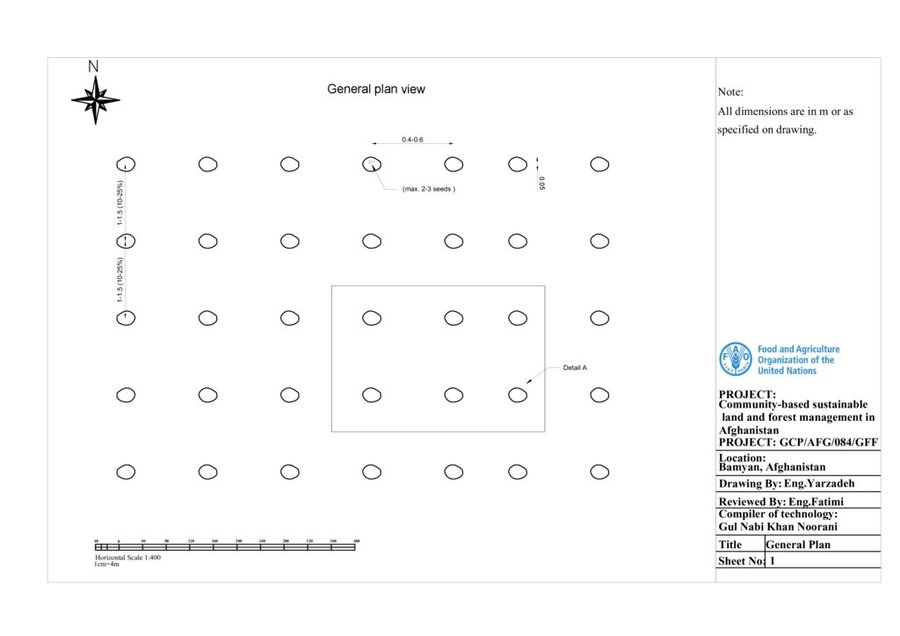
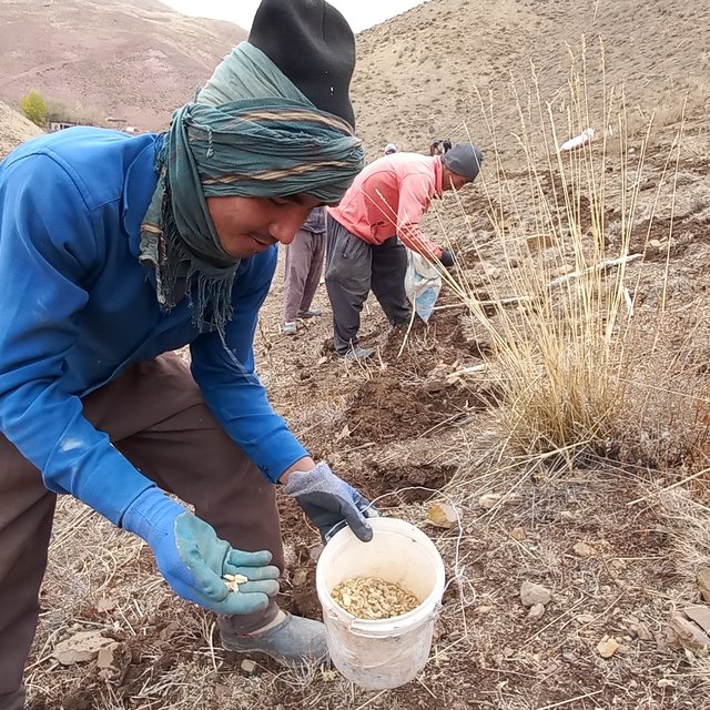
7.Method of Reseeding: The inter and intra-row space between seeding pits (max. 2-3 seeds in one pit) depends on the slope of the terrain, canopy of the fodder, and extent of vegetation cover. If the % slope of the terrain is increasing and canopy of planted species is small, then the space between two rows and two plants decreases and vice versa. Normally, the space between two rows is 1-1.5 m and two plants are about 40-60 cms apart. On the day of reseeding, some land users dig small pits using a hoe and shovel approximately five centimeters deep, followed by another person who puts seeds in the pit and covers the seed with soil using his own boot. The distance between pits is estimated through a person's step. One person reseeds 3.5 kgs of seed per working day. Roughly, a total of 15 kgs of fodder seed is needed for 1 ha of rangeland. It's worth mentioning that the quantity of seed per ha depends on the space between rows and plants and the size of the fodder seed itself.

The seeds are collected using the cash-for-work model. This served (i) to provide income support to poor, vulnerable men and women through short-term employment and (ii) to rehabilitate public assets (rangelands) that are vital for sustaining the livelihoods of livestock rearing. Both men and women-headed vulnerable households benefited from the cash-for-work program of seed collection. More importantly, these fodder species’ seeds are fresh, locally adapted, nutritious for livestock (help fatten livestock), available locally, and inexpensive compared to other types of fodder seed. The germination percentage of the seed and growth of the fodder is significantly high in the reseeded area.

Traditionally, rural communities knew that fodder crops grew from seeds; however, the main stems with inflorescences and spikelets were harvested before maturity and used as fuelwood for heating and cooking. Through awareness-raising campaigns and training workshops within the project, farmers were encouraged to leave the main stems intact for seed maturation, allowing for natural seed dispersal and seed collection for reseeding. The success of natural reseeding is limited compared to artificial reseeding due to several factors. In natural reseeding, seeds are often exposed and not covered by soil, making them vulnerable to environmental conditions. Moisture availability may also be insufficient for germination, and existing vegetation can compete with new growth. In contrast, artificial reseeding ensures that seeds are properly covered, protected, and placed in areas with optimal moisture, which increases the likelihood of successful germination and establishment. Recently, the demand for the local fodder seed has dramatically increased because many non-profit organizations and private businesses are purchasing these seeds. It created a new source of income for the rural communities.

Finally, the technology combines both traditional knowledge and scientific understanding, contributing to more effective restoration of the degraded rangeland ecosystem, improving soil health, and increasing fodder availability, which contributed to livelihood resilience and improvement.

Location

Location: Punjab and Yakawalang districts, Bamyan, Afghanistan

No. of Technology sites analysed: 10-100 sites

Geo-reference of selected sites
  • 66.97805, 34.61111
  • 66.97783, 34.61121
  • 67.01033, 34.61149
  • 66.82883, 34.62109
  • 66.88161, 34.79239
  • 66.99602, 34.6162
  • 66.81328, 34.70845
  • 66.99691, 34.34084
  • 67.15063, 34.36734
  • 67.18082, 34.38401
  • 67.10792, 34.41338
  • 66.9622, 34.58658
  • 66.98435, 34.60009
  • 66.97794, 34.61083
  • 66.97805, 34.61111

Spread of the Technology: applied at specific points/ concentrated on a small area

In a permanently protected area?: Nee

Date of implementation: 2021

Type of introduction
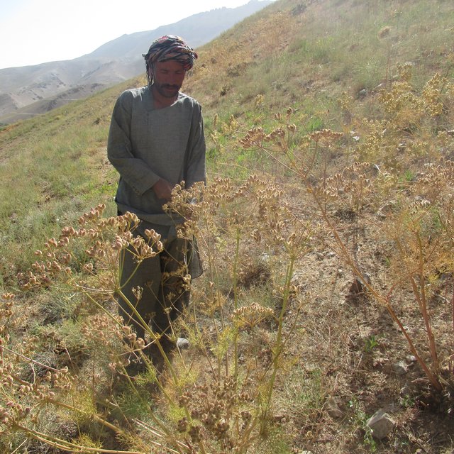
Collection of local fodder Umbelliferae ferulus (Gheghu) seeds at their maturity stage. (Gul Nabi Khan)
Reseeding process, where 2–3 seeds are carefully placed into each pit. (Gul Nabi Khan)

Classification of the Technology

Main purpose
  • improve production
  • reduce, prevent, restore land degradation
  • conserve ecosystem
  • protect a watershed/ downstream areas – in combination with other Technologies
  • preserve/ improve biodiversity
  • reduce risk of disasters
  • adapt to climate change/ extremes and its impacts
  • mitigate climate change and its impacts
  • create beneficial economic impact
  • create beneficial social impact
Land use
Land use mixed within the same land unit: Nee

  • Grazing land
    • Semi-nomadic pastoralism
    • Improved pastures
    • Direct grazing and remaining fodder is cut for animal feeding
    Animal type: cattle - dairy, goats, sheep
    Is integrated crop-livestock management practiced? Nee
    Products and services: meat, milk, whool
      SpeciesCount
      sheep647703
      goats250869
      cattle - dairy165274
    Water supply
    • rainfed
    • mixed rainfed-irrigated
    • full irrigation

    Purpose related to land degradation
    • prevent land degradation
    • reduce land degradation
    • restore/ rehabilitate severely degraded land
    • adapt to land degradation
    • not applicable
    Degradation addressed
    • soil erosion by water - Wt: loss of topsoil/ surface erosion, Wg: gully erosion/ gullying, Wm: mass movements/ landslides
    • biological degradation - Bc: reduction of vegetation cover, Bh: loss of habitats, Bq: quantity/ biomass decline, Bs: quality and species composition/ diversity decline
    SLM group
    • area closure (stop use, support restoration)
    • pastoralism and grazing land management
    • improved ground/ vegetation cover
    • rangeland restoration
    SLM measures
    • vegetative measures - V2: Grasses and perennial herbaceous plants
    • management measures - M1: Change of land use type

    Technical drawing

    Technical specifications
    General specifications of the technology:
    1. Local fodder crops, such as species from the Ferula and Prangos genera, are well-suited to semi-arid conditions due to their drought and cold resistance.
    2. A moderate slope of 10-25% is ideal for reseeding.
    3. On such slopes, the recommended distance between two rows is 1-1.5 meters, while the spacing between two seeding pits should be 0.40-0.60 meters. The spacing between pits can be estimated using a person’s step. The depth of each pit should be approximately 0.05 meters.
    4.The width of the pit is determined by a single strike with a hoe or mattock.
    5. The distance between rows and plants can vary depending on the slope, soil type, vegetation cover, and canopy size of the fodder crop. For steeper slopes or species with small canopies, the spacing between rows and plants should be reduced, and vice versa.
    6.Small pits for planting are dug using tools such as hoes or mattocks.
    7. 2-3 seeds are placed in each pit.
    8. The seeds are covered with soil using a person's foot, boot, or a similar implement.
    9. Approximately 15 kilograms of seed are required per hectare for reseeding using this technology.
    10. It is important to note that the quantity of seed required per hectare depends on the spacing between rows and plants, as well as the size of the seed.
    Author: Ms. Samira Yarzadeh and Mr. Sayed Habibullah Fatimi

    Establishment and maintenance: activities, inputs and costs

    Calculation of inputs and costs
    • Costs are calculated: per Technology area (size and area unit: 539 hectares)
    • Currency used for cost calculation: AFN
    • Exchange rate (to USD): 1 USD = 69.0 AFN
    • Average wage cost of hired labour per day: 350 AFN
    Most important factors affecting the costs
    The most important factors affecting the costs are the seed of local fodder types and their availability during the growing season, as well as the cost of rangers patrolling the technology area.
    Establishment activities
    1. Identification of locally adapted drought-resistant and palatable fodder species by livestock owners and land users. (Timing/ frequency: April and May)
    2. Identification of highly producing areas of selected fodder species for seed collection. (Timing/ frequency: June and July)
    3. Defer grazing and delay fodder harvest for the purpose of seed maturity in the targeted area. (Timing/ frequency: June, July, August and September)
    4. Awareness raising about the maturity stages of different fodder species seeds: (Timing/ frequency: August and September)
    5. Collecting, drying, and storing seed (Timing/ frequency: September)
    6. Sites identification for reseeding (Timing/ frequency: September)
    7. Mobilization of community members for reseeding campaign (Timing/ frequency: September and October)
    8. Reseeding: Transporting seed and agricultural tools to the area, preparation of field, digging planting pits, reseeding and covering the seed. (Timing/ frequency: October and November)
    9. Control grazing in the next growing season (Timing/ frequency: April, May, June, July (following year))
    Establishment inputs and costs (per 539 hectares)
    Specify input Unit Quantity Costs per Unit (AFN) Total costs per input (AFN) % of costs borne by land users
    Labour
    Collecting of local fodder seed (Kami, Ghegho, Chukri, Khola, Badra, Qarghana) person-days 5.0 350.0 1750.0
    Drying and storing of local fodder seed person-days 3.0 350.0 1050.0
    Reseeding of local fodder seed in rangeland person-days 8.0 350.0 2800.0 100.0
    Equipment
    Pit digging equipment i.e., shovel, hoe, pick mattock no. 5.0 250.0 1250.0 100.0
    Plastic bags for collecting seed (reusable) pieces 3.0 20.0 60.0 100.0
    Total costs for establishment of the Technology 6'910.0
    Total costs for establishment of the Technology in USD 100.14
    Maintenance activities
    1. Control grazing and fodder harvesting (Timing/ frequency: 12 months/ annually)
    2. Restrict cutting perennial shrubs for forage, firewood and their uprooting (Timing/ frequency: 12 months/ annually)
    3. Reseeding is done in the pits where there was no germination. (Timing/ frequency: Growing season/ once a year)
    4. Conduct workshops and awareness raising for herders on SLM. (Timing/ frequency: Growing season/ twice a year)
    Maintenance inputs and costs (per 539 hectares)
    Specify input Unit Quantity Costs per Unit (AFN) Total costs per input (AFN) % of costs borne by land users
    Labour
    Community members, acting as rangers, patrol the area to control grazing, fodder collection, and shrub harvesting person-day 240.0 200.0 48000.0 100.0
    Reseeding of pits where there was no germination. person-day 2.0 350.0 700.0 100.0
    Conduct awareness raising for herders on SLM. no. 3.0 3000.0 9000.0
    Total costs for maintenance of the Technology 57'700.0
    Total costs for maintenance of the Technology in USD 836.23

    Natural environment

    Average annual rainfall
    • < 250 mm
    • 251-500 mm
    • 501-750 mm
    • 751-1,000 mm
    • 1,001-1,500 mm
    • 1,501-2,000 mm
    • 2,001-3,000 mm
    • 3,001-4,000 mm
    • > 4,000 mm
    Agro-climatic zone
    • humid
    • sub-humid
    • semi-arid
    • arid
    Specifications on climate
    Average annual rainfall in mm: 150.0
    The average annual rainfall in Bamyan, Afghanistan, is relatively low, as the region is characterized by a semi-arid to arid climate. On average it is around 100–150 mm annually.
    Most of the precipitation occurs during the spring season (March to May) and occasionally in the early summer. Snowfall is common in the winter months due to Bamyan's high elevation (about 2,500-3,000 meters above sea level), contributing to water availability through snowmelt in spring and summer seasons.
    Name of the meteorological station: World weather online
    The mean annual temperature in Bamyan varies around 6–8°C (43–46°F). The region experiences a wide temperature range throughout the year due to its high-altitude and semi-arid climate. Bamyan winters are very cold and snowy, while summers are hot and dry.
    Winter (December–February): Extremely cold, with average temperatures ranging from -10°C to -15°C (14°F to 5°F). Nights can be even colder, with temperatures dropping below -30°C (-4°F).
    Summer (June–August): Relatively mild, with average daytime temperatures around 20–25°C (68–77°F). Nights remain cool due to the high altitude.
    Spring and Autumn: Transition seasons with moderate temperatures, ranging from 5–15°C (41–59°F).
    Slope
    • flat (0-2%)
    • gentle (3-5%)
    • moderate (6-10%)
    • rolling (11-15%)
    • hilly (16-30%)
    • steep (31-60%)
    • very steep (>60%)
    Landforms
    • plateau/plains
    • ridges
    • mountain slopes
    • hill slopes
    • footslopes
    • valley floors
    Altitude
    • 0-100 m a.s.l.
    • 101-500 m a.s.l.
    • 501-1,000 m a.s.l.
    • 1,001-1,500 m a.s.l.
    • 1,501-2,000 m a.s.l.
    • 2,001-2,500 m a.s.l.
    • 2,501-3,000 m a.s.l.
    • 3,001-4,000 m a.s.l.
    • > 4,000 m a.s.l.
    Technology is applied in
    • convex situations
    • concave situations
    • not relevant
    Soil depth
    • very shallow (0-20 cm)
    • shallow (21-50 cm)
    • moderately deep (51-80 cm)
    • deep (81-120 cm)
    • very deep (> 120 cm)
    Soil texture (topsoil)
    • coarse/ light (sandy)
    • medium (loamy, silty)
    • fine/ heavy (clay)
    Soil texture (> 20 cm below surface)
    • coarse/ light (sandy)
    • medium (loamy, silty)
    • fine/ heavy (clay)
    Topsoil organic matter content
    • high (>3%)
    • medium (1-3%)
    • low (<1%)
    Groundwater table
    • on surface
    • < 5 m
    • 5-50 m
    • > 50 m
    Availability of surface water
    • excess
    • good
    • medium
    • poor/ none
    Water quality (untreated)
    • good drinking water
    • poor drinking water (treatment required)
    • for agricultural use only (irrigation)
    • unusable
    Water quality refers to: ground water
    Is salinity a problem?
    • Ja
    • Nee

    Occurrence of flooding
    • Ja
    • Nee
    Species diversity
    • high
    • medium
    • low
    Habitat diversity
    • high
    • medium
    • low

    Characteristics of land users applying the Technology

    Market orientation
    • subsistence (self-supply)
    • mixed (subsistence/ commercial)
    • commercial/ market
    Off-farm income
    • less than 10% of all income
    • 10-50% of all income
    • > 50% of all income
    Relative level of wealth
    • very poor
    • poor
    • average
    • rich
    • very rich
    Level of mechanization
    • manual work
    • animal traction
    • mechanized/ motorized
    Sedentary or nomadic
    • Sedentary
    • Semi-nomadic
    • Nomadic
    Individuals or groups
    • individual/ household
    • groups/ community
    • cooperative
    • employee (company, government)
    Gender
    • women
    • men
    Age
    • children
    • youth
    • middle-aged
    • elderly
    Area used per household
    • < 0.5 ha
    • 0.5-1 ha
    • 1-2 ha
    • 2-5 ha
    • 5-15 ha
    • 15-50 ha
    • 50-100 ha
    • 100-500 ha
    • 500-1,000 ha
    • 1,000-10,000 ha
    • > 10,000 ha
    Scale
    • small-scale
    • medium-scale
    • large-scale
    Land ownership
    • state
    • company
    • communal/ village
    • group
    • individual, not titled
    • individual, titled
    Land use rights
    • open access (unorganized)
    • communal (organized)
    • leased
    • individual
    Water use rights
    • open access (unorganized)
    • communal (organized)
    • leased
    • individual
    Access to services and infrastructure
    health

    poor
    x
    good
    education

    poor
    x
    good
    technical assistance

    poor
    x
    good
    employment (e.g. off-farm)

    poor
    x
    good
    markets

    poor
    x
    good
    energy

    poor
    x
    good
    roads and transport

    poor
    x
    good
    drinking water and sanitation

    poor
    x
    good
    financial services

    poor
    x
    good
    Comments

    Access to services and infrastructure in Bamyan Province is limited due to its remote location and mountainous terrain. Basic services such as healthcare, education, and clean water are available but often insufficient, particularly in rural areas. Infrastructure like roads and electricity is underdeveloped.

    Impacts

    Socio-economic impacts
    fodder production
    decreased
    x
    increased

    Quantity before SLM: 560 Kg/hectare
    Quantity after SLM: 1050 kg/hectare
    The fodder production per hectare in Bamyan’s rangelands varies significantly based on land conditions and management practices. In rehabilitated rangelands, such as those supported by FAO projects, forage production enhanced through reseeding and rotational grazing strategies.

    animal production
    decreased
    x
    increased

    Quantity before SLM: 6 litters milk/cow/day
    Quantity after SLM: 12 litters milk/cow/day
    The integration of indigenous and scientific fodder production techniques (reseeding of local fodder) and availability of nutritious fodder has boosted both health and livestock productivity sustainably.

    production area (new land under cultivation/ use)
    decreased
    x
    increased

    Quantity before SLM: 0
    Quantity after SLM: 539 hectares
    The fodder producing area has been increased from zero to hunderd hectares of rangeland.

    drinking water availability
    decreased
    x
    increased

    Quantity before SLM: 5 liters/minute (discharge of spring)
    Quantity after SLM: 11 liters/minute (discharge of spring)
    Reseeding and improving vegetation cover on rangelands significantly enhanced the infiltration of rainfall and snowmelt, ultimately benefiting underground water reserves and increasing the availability of animal drinking points, irrigation water and drinking water sources such as spring.

    water availability for livestock
    decreased
    x
    increased

    irrigation water availability
    decreased
    x
    increased

    diversity of income sources
    decreased
    x
    increased

    Quantity before SLM: Potato cultivation and Livestock
    Quantity after SLM: Potato cultivation, livestock and seed collection
    RMA members now harvest fodder seeds once they reach maturity and sell them in the market, contributing to both local livelihoods (income) and the sustainability of rangeland management.

    Socio-cultural impacts
    community institutions
    weakened
    x
    strengthened

    Quantity before SLM: Zero community institution
    Quantity after SLM: 7 rangeland management associations (RMAs)
    The community institutions in the area are primarily organized as Rangeland Management Associations (RMAs).

    SLM/ land degradation knowledge
    reduced
    x
    improved

    Quantity before SLM: Zero capacity building workshop
    Quantity after SLM: Capacity of 10,000 RMA's member build.
    The capacity of RMA members is enhanced through training, community-based workshops, and awareness-raising initiatives focused on Sustainable Land Management (SLM) and Sustainable Forest Management (SFM).

    conflict mitigation
    worsened
    x
    improved

    Quantity before SLM: 4 conflicts / village/year
    Quantity after SLM: 0 conflicts/village/year
    Increasing the quantity and availability of water and fodder helps reduce conflicts by addressing resource scarcity, which is often a source of tension. When communities have enough access to these essential resources, competition decreases, and cooperation can grow.

    Ecological impacts
    soil cover
    reduced
    x
    improved

    Quantity before SLM: 30-40%
    Quantity after SLM: 70-80%
    Reseeding improves soil cover, protecting it from erosion, stabilizing the soil, enhancing water retention, and restoring nutrients. This supports ecosystem recovery and promotes healthier soils and sustainable land use.

    soil loss
    increased
    x
    decreased

    Quantity before SLM: 40-50%
    Quantity after SLM: 0
    Soil loss varies depending on topography, land use, and management practices. Soil loss rates typically range between 2.2 to 38 tons per hectare per year (t/ha/year), depending on slope steepness and vegetation cover. Higher rates are observed in areas with steep terrain and minimal vegetation, while conservation practices can reduce these rates significantly.

    vegetation cover
    decreased
    x
    increased

    Quantity before SLM: 30-40%
    Quantity after SLM: 70-80%
    Reseeding improved vegetation coverage by introducing new plant seeds to degraded areas, promoting their regrowth and restoring ecosystems.

    biomass/ above ground C
    decreased
    x
    increased

    Quantity before SLM: 0.2-2 Ton/hectare
    Quantity after SLM: 4-5 ton/hectare
    Reseeding local fodder seeds in rangelands enhances aboveground biomass carbon by increasing vegetation growth, which sequesters more carbon.

    plant diversity
    decreased
    x
    increased

    Quantity before SLM: 5-15 species/species/square meter
    Quantity after SLM: 15-25 species/species/square meter
    Plant diversity is relatively high, featuring a variety of native grasses, shrubs, and medicinal plants adapted to the region's arid and semi-arid conditions. The plant diversity can vary widely depending on factors like altitude, grazing pressure, and management practices.

    beneficial species (predators, earthworms, pollinators)
    decreased
    x
    increased

    Quantity before SLM: 0
    Quantity after SLM: 2-5 species/ technology area
    Bees and birds

    flood impacts
    increased
    x
    decreased

    Quantity before SLM: 2-3 floods / year
    Quantity after SLM: 0 floods/year
    Reseeding reduces flooding by establishing vegetation cover that stabilizes the soil, enhances water infiltration, and slows surface runoff, thus decreasing the volume and velocity of water that can lead to floods.

    landslides/ debris flows
    increased
    x
    decreased

    Quantity before SLM: 50,000 m3/winter season
    Quantity after SLM: 5000 m3/winter season
    Reseeding helps reduce landslides by promoting the growth of vegetation, the roots bind soil particles together, increasing slope stability and reducing soil erosion caused by water runoff and snow fall.

    drought impacts
    increased
    x
    decreased

    Quantity before SLM: 560 Kg/hectare (fodder yield)
    Quantity after SLM: 1050 kg/hectare (fodder yield)
    Reseeding of different fodder species enhances soil moisture retention, reduce surface evaporation, and improve water infiltration.

    Off-site impacts
    water availability (groundwater, springs)
    decreased
    x
    increased

    Quantity before SLM: 5 liters/minute (discharge of spring)
    Quantity after SLM: 11 liters/minute (discharge of spring)
    Reseeding and improving vegetation cover enhanced the infiltration of rainfall and snowmelt, ultimately benefiting ground water recharge and increasing water availability: animal drinking points, irrigation water and drinking water sources such as springs.

    downstream flooding (undesired)
    increased
    x
    reduced

    Quantity before SLM: 2-3 floods/year
    Quantity after SLM: 0 floods/year
    Vegetation cover stabilizes the soil, enhances water infiltration, and slows surface runoff, thus decreasing the volume and velocity of water that can lead downstream floodsing and damage.

    downstream siltation
    increased
    x
    decreased

    Quantity before SLM: 2-3 floods/year
    Quantity after SLM: 0 floods/year
    Reseeding helps reduce downstream siltation and river water pollution by stabilizing the soil, preventing erosion, and promoting the growth of vegetation that intercepts and filters runoff.

    buffering/ filtering capacity (by soil, vegetation, wetlands)
    reduced
    x
    improved


    Reseeding helped increase buffering and filtering capacity by reintroducing vegetation that acts as a natural barrier against pollutants and runoff. The plant roots stabilize the soil, reducing erosion, while the vegetation cover slows water movement, allowing it to infiltrate the ground.

    damage on neighbours' fields
    increased
    x
    reduced

    Quantity before SLM: 2-3 floods/year
    Quantity after SLM: 0 floods/year
    Reseeding and better soil cover helped reduce flash flood damage to neighboring agricultural fields downstream.

    impact of greenhouse gases
    increased
    x
    reduced

    Quantity before SLM: 0.5-2 tons of sequestered CO₂/ hectare annually
    Quantity after SLM: 3-4 tons of sequestered CO₂/ hectare annually
    Reseeding reduces greenhouse gases by enhancing carbon sequestration in plants and soil, while also minimizing emissions of nitrous oxide and methane from degraded areas.

    Cost-benefit analysis

    Benefits compared with establishment costs
    Short-term returns
    very negative
    x
    very positive

    Long-term returns
    very negative
    x
    very positive

    Benefits compared with maintenance costs
    Short-term returns
    very negative
    x
    very positive

    Long-term returns
    very negative
    x
    very positive

    Reseeding Bamyan rangelands requires investment in seeds, labor, and maintenance, but provides long-term benefits like better vegetation, soil stability, and carbon sequestration. It improves grazing, reduces flood and erosion risks, and helps mitigate climate impacts. The ecological and economic gains outweigh the initial costs.

    Climate change

    Gradual climate change
    annual temperature decrease

    not well at all
    x
    very well
    annual rainfall increase

    not well at all
    x
    very well
    Climate-related extremes (disasters)
    drought

    not well at all
    x
    very well
    flash flood

    not well at all
    x
    very well
    landslide

    not well at all
    x
    very well
    avalanche

    not well at all
    x
    very well

    Adoption and adaptation

    Percentage of land users in the area who have adopted the Technology
    • single cases/ experimental
    • 1-10%
    • 11-50%
    • > 50%
    Of all those who have adopted the Technology, how many have done so without receiving material incentives?
    • 0-10%
    • 11-50%
    • 51-90%
    • 91-100%
    Has the Technology been modified recently to adapt to changing conditions?
    • Ja
    • Nee
    To which changing conditions?
    • climatic change/ extremes
    • changing markets
    • labour availability (e.g. due to migration)

    Conclusions and lessons learnt

    Strengths: land user's view
    • Enhances the availability of high-quality forage, leading to better livestock health and productivity.
    • Restores degraded land which increasing grazing rangeland area.
    • Alternative source of income through temporary employment.
    • It's easy to adopt and many pastoral communities have already replicated.
    • It requires locally available seeds, labor, and traditional knowledge, making it cost-effective and practical for communities to implement.
    • Community members choose palatable, nutritious and drought resistant fodder species which enhance their livestock production.
    Strengths: compiler’s or other key resource person’s view
    • Reseeded areas help control soil erosion and improve soil fertility through vegetation cover.
    • Improved biodiversity through the reintroduction of native species.
    • Reseeding supports carbon sequestration and contributes to climate resilience and adaptation.
    • The technology involved local communities which ensures better understanding, ownership, replication and sustainability of the process.
    • Local or indigenous species used in reseeding are well-adapted to local conditions, increasing the likelihood of successful germination and growth.
    • Through training and awareness raising, now community members are allowing fodder to grow until seeds are fully mature ensures effective seed production (collection) and natural dispersal, aiding in rangeland regeneration and biodiversity improvement.
    • Alternative income through employment in local fodder seed collection and sales.
    Weaknesses/ disadvantages/ risks: land user's viewhow to overcome
    • Reseeding requires an initial investment in establishing a rangeland management association, seeds and labor. By establishing RMA and mobilizing community members to contribute and seek funding from governments, NGOs, or international organizations.
    • Control grazing: Livestock grazing in reseeded areas can damage young plants, reducing effectiveness. Require an agreement with community to control grazing in the area. Also, implement rotational grazing systems and fencing to protect reseeded areas until vegetation is established.
    • Benefits from reseeding take time to return, potentially discouraging land users seeking quick results. Identify alternative grazing area. Provide short-term solution of supplemental feed to address immediate needs.
    Weaknesses/ disadvantages/ risks: compiler’s or other key resource person’s viewhow to overcome
    • Implementing reseeding may limit access to grazing lands temporarily, potentially causing disputes among land users, especially in areas with shared resources. Agreement of all land users is required.
    • Reseeding success is highly dependent on favorable weather conditions. Drought or erratic rainfall can lead to poor germination and growth. Explore the potential to integrate rainwater harvesting structures in future reseeding activities

    References

    Compiler
    • Gul Nabi Khan Noorani
    Editors
    • Mir Wali Khan Lakanwal
    • Mohammad Mustafa Sahebzada
    Reviewer
    • Rima Mekdaschi Studer
    • Illias Animon
    • Muhammad Ishaq Safi
    Date of documentation: Nov. 13, 2024
    Last update: Maart 24, 2025
    Resource persons
    Full description in the WOCAT database
    Linked SLM data
    Documentation was faciliated by
    Institution Project
    Key references
    • The Status of Forage Production in Afghanistan: Forage Options for Smallholder Livestock in Water-Scarce Environments of Afghanistan. Ates, S., Hassan, S., Soofizada, Q., Biradar, C., Esmati, H., & Louhaichi, M. (2018).: https://research.aciar.gov.au/aik-saath/sites/_co-lab.aciar.gov.au.aik-saath/files/2020-08/ICARDA%20forage%20Afghanistan_0.pdf
    • FAO brings life to degraded rangeland thanks to GEF funding. FAO, 2022: https://www.fao.org/afghanistan/news/detail-events/en/c/1505486/
    • Community-based Sustainable Land and Forest Management in Afghanistan,: https://www.thegef.org/projects-operations/projects/9285
    • An introductory guide to sources of traditional fodder and forage and usage, Anthony Fitzherbert, 2014: https://www.acbar.org/upload/1493193872857.pdf
    Links to relevant information which is available online
    This work is licensed under Creative Commons Attribution-NonCommercial-ShareaAlike 4.0 International