Sunken gully pits [India]
- Creation:
- Update:
- Compiler: SATYANARAYANA SAHU
- Editor: –
- Reviewer: Fabian Ottiger
khancha, Dhuda
technologies_1479 - India
View sections
Expand all Collapse all1. General information
1.2 Contact details of resource persons and institutions involved in the assessment and documentation of the Technology
SLM specialist:
SLM specialist:
Nayak Pradeep Kumar
Nuapada, Orissa, India
India
1.3 Conditions regarding the use of data documented through WOCAT
When were the data compiled (in the field)?
10/10/2006
The compiler and key resource person(s) accept the conditions regarding the use of data documented through WOCAT:
Ja
1.5 Reference to Questionnaire(s) on SLM Approaches
Participatory Watershed Development Approach [India]
Livelihood asset base development through participatory watershed developemnt keeping people at the center stage of development and promoting village level institutions.
- Compiler: Narendra Kumar Panigrahi
2. Description of the SLM Technology
2.1 Short description of the Technology
Definition of the Technology:
Runoff management pit in the gully with provision of waterway for excess runoff water.
2.2 Detailed description of the Technology
Description:
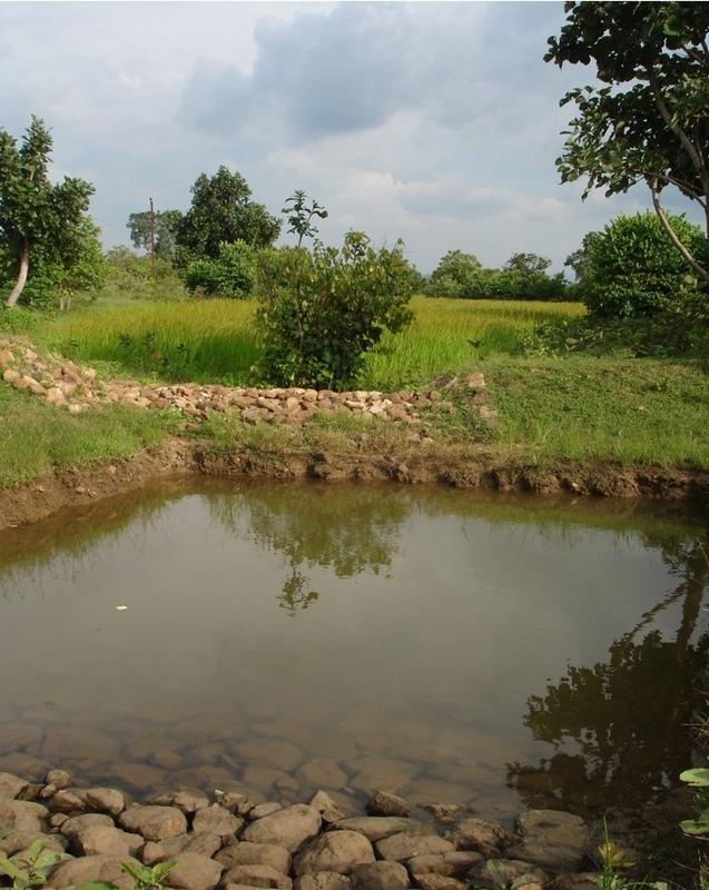
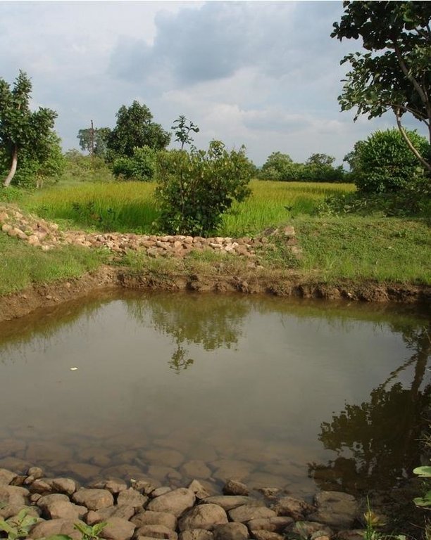
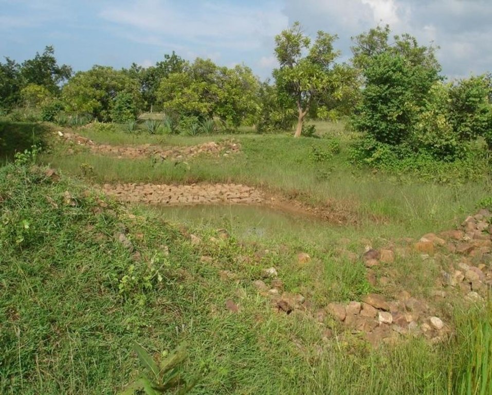
Adopted in 4-8% sloped gully at an interval varying from 20 M to 30 M . Pits are dug on the upsteam of the bund with graded slope or the upsteam of the pits. Also having provision of safe water disposal. Purpose: 1. Reduction in flow velocity 2. Withheld and impound the flow water 3. Ground water recharge 4. Increase in soil moisture regime 5. For supplemental irrigation by the middle and lower reach structure. Establishment/maintenance: Turfing, Placing in position of displaced boulder. Excavation of deposited earth from the pit. Environment: User friendly, Low maintenance, Promotes vegetation,Eco-friendly
2.3 Photos of the Technology
2.5 Country/ region/ locations where the Technology has been applied and which are covered by this assessment
Country:
India
Region/ State/ Province:
ORISSA
Further specification of location:
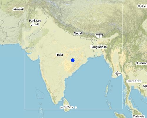
ORISSA/NUAPADA/MAHANADI/CHAKAPADA
Map
×2.6 Date of implementation
If precise year is not known, indicate approximate date:
- more than 50 years ago (traditional)
2.7 Introduction of the Technology
Specify how the Technology was introduced:
- through projects/ external interventions
Comments (type of project, etc.):
ANDHRA PRADESH By Hanumant Rao based upon Four- Water concept.
3. Classification of the SLM Technology
3.1 Main purpose(s) of the Technology
- reduce, prevent, restore land degradation
- adapt to climate change/ extremes and its impacts
3.2 Current land use type(s) where the Technology is applied

Mixed (crops/ grazing/ trees), incl. agroforestry
- Silvo-pastoralism
Main products/ services:
Shrubs, trees and fodder cultivation. Also: fuelwood, fruits and nuts, grazing / browsing, other forest products / uses (honey, medical, etc.), nature conservation / protection, recreation / tourism
Comments:
Major land use problems (compiler’s opinion): Formation and development of gully in course of time.
Major land use problems (land users’ perception): Problem of sand casting in crop land and graduallly coverted into unproductive lands.
Semi-nomadism / pastoralism: Animals reside in the Watershed area
Grazingland comments: Trend increasing towards livestock production. Trend to have stall feeding. Trend to produce better and improved quality fodder.
Plantation forestry: Yes
Other type of forest: Natural forest
Problems / comments regarding forest use: Management and protection of existing forest and species are increasing by providing watch and ward by the Watershed members through Vana Surakhya Samiti(Forest Protection Committee)
3.3 Further information about land use
Water supply for the land on which the Technology is applied:
- rainfed
Number of growing seasons per year:
- 2
Specify:
Longest growing period in days: 150 Longest growing period from month to month: Jun - Oct Second longest growing period in days: 75 Second longest growing period from month to month: Nov - Jan
3.4 SLM group to which the Technology belongs
- water harvesting
- irrigation management (incl. water supply, drainage)
- ground water management
3.5 Spread of the Technology
Specify the spread of the Technology:
- evenly spread over an area
If the Technology is evenly spread over an area, indicate approximate area covered:
- 0.1-1 km2
Comments:
Total area covered by the SLM Technology is 0.4 m2.
Technology adopted following T.Hanumanth Rao's four- Water concept.
3.6 SLM measures comprising the Technology
3.7 Main types of land degradation addressed by the Technology

soil erosion by water
- Wt: loss of topsoil/ surface erosion
- Wg: gully erosion/ gullying
- Wo: offsite degradation effects
Comments:
Main type of degradation addressed: Wg: gully erosion / gullying
Secondary types of degradation addressed: Wt: loss of topsoil / surface erosion, Wo: offsite degradation effects
3.8 Prevention, reduction, or restoration of land degradation
Specify the goal of the Technology with regard to land degradation:
- prevent land degradation
- reduce land degradation
Comments:
Main goals: prevention of land degradation
Secondary goals: mitigation / reduction of land degradation
4. Technical specifications, implementation activities, inputs, and costs
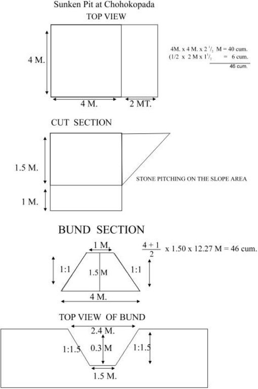
4.1 Technical drawing of the Technology
4.2 Technical specifications/ explanations of technical drawing
Sunken pit technical drawing
Technical knowledge required for field staff / advisors: moderate
Technical knowledge required for land users: low
Main technical functions: control of dispersed runoff: retain / trap, control of concentrated runoff: impede / retard, increase of infiltration, increase / maintain water stored in soil
Secondary technical functions: control of concentrated runoff: retain / trap, control of concentrated runoff: drain / divert, reduction of slope angle, reduction of slope length, sediment retention / trapping, sediment harvesting, increase in soil fertility
Vegetative measure: Turf on bund
Vegetative material: G : grass
Vegetative measure: Vegetative material: G : grass
Vegetative measure: Vegetative material: G : grass
Vegetative measure: Vegetative material: G : grass
Grass species: Local grass
Slope (which determines the spacing indicated above): 3.00%
If the original slope has changed as a result of the Technology, the slope today is (see figure below): 2.00%
Gradient along the rows / strips: 0.00%
Structural measure: Sunken gully pit
Vertical interval between structures (m): 1
Spacing between structures (m): 20
Depth of ditches/pits/dams (m): 1
Width of ditches/pits/dams (m): 2
Length of ditches/pits/dams (m): 3
Height of bunds/banks/others (m): 1
Width of bunds/banks/others (m): 2.5
Length of bunds/banks/others (m): 3
Construction material (earth): Excavated earth over 4.5 cum is utilised for construction of down stream bund
Construction material (stone): 1.08 cum of stone is used in upstream pit slope
Slope (which determines the spacing indicated above): 3%
If the original slope has changed as a result of the Technology, the slope today is: 2%
Lateral gradient along the structure: 0%
Vegetation is used for stabilisation of structures.
4.3 General information regarding the calculation of inputs and costs
other/ national currency (specify):
Rupees
Indicate exchange rate from USD to local currency (if relevant): 1 USD =:
50.0
Indicate average wage cost of hired labour per day:
1.00
4.4 Establishment activities
| Activity | Type of measure | Timing | |
|---|---|---|---|
| 1. | Local grass collection | Vegetative | Onset of monsoon(Jun-july) |
| 2. | Putting the turf on the bund | Vegetative | Onset of monsoon(Jun-july) |
| 3. | Establishment of grass | Vegetative | During monsoon |
| 4. | Survey and layout | Structural | before onset of rain. |
| 5. | digging of pit & construction of earthen bund | Structural | pre-monsoon |
| 6. | stone pitching on upstream slope of pit | Structural | pre-monsoon |
| 7. | grass turffing | Structural | monsoon |
4.5 Costs and inputs needed for establishment
| Specify input | Unit | Quantity | Costs per Unit | Total costs per input | % of costs borne by land users | |
|---|---|---|---|---|---|---|
| Labour | Labour | ha | 1.0 | 37.0 | 37.0 | |
| Construction material | Stone | ha | 1.0 | 3.0 | 3.0 | |
| Total costs for establishment of the Technology | 40.0 | |||||
Comments:
Duration of establishment phase: 12 month(s)
4.6 Maintenance/ recurrent activities
| Activity | Type of measure | Timing/ frequency | |
|---|---|---|---|
| 1. | Replanting of grass in the dried out patches | Vegetative | During rainy season(July-Sept) /When required. |
| 2. | stabilisatioin of bund with grass | Structural | during rain/annual |
| 3. | de-silting of pit | Structural | Before onset of monsoon/annual |
| 4. | Maintaing upstream & down stream bund slope | Structural | Before onset of rain/annual |
| 5. | Re-arrangement of displaced stones | Structural | before onset of rain/annual |
4.7 Costs and inputs needed for maintenance/ recurrent activities (per year)
Comments:
Length of structure , deapth of gully , stone availability
4.8 Most important factors affecting the costs
Describe the most determinate factors affecting the costs:
Labour availability, stone transportation.
5. Natural and human environment
5.1 Climate
Annual rainfall
- < 250 mm
- 251-500 mm
- 501-750 mm
- 751-1,000 mm
- 1,001-1,500 mm
- 1,501-2,000 mm
- 2,001-3,000 mm
- 3,001-4,000 mm
- > 4,000 mm
Specify average annual rainfall (if known), in mm:
1250.00
Agro-climatic zone
- semi-arid
5.2 Topography
Slopes on average:
- flat (0-2%)
- gentle (3-5%)
- moderate (6-10%)
- rolling (11-15%)
- hilly (16-30%)
- steep (31-60%)
- very steep (>60%)
Landforms:
- plateau/plains
- ridges
- mountain slopes
- hill slopes
- footslopes
- valley floors
Altitudinal zone:
- 0-100 m a.s.l.
- 101-500 m a.s.l.
- 501-1,000 m a.s.l.
- 1,001-1,500 m a.s.l.
- 1,501-2,000 m a.s.l.
- 2,001-2,500 m a.s.l.
- 2,501-3,000 m a.s.l.
- 3,001-4,000 m a.s.l.
- > 4,000 m a.s.l.
5.3 Soils
Soil depth on average:
- very shallow (0-20 cm)
- shallow (21-50 cm)
- moderately deep (51-80 cm)
- deep (81-120 cm)
- very deep (> 120 cm)
Soil texture (topsoil):
- medium (loamy, silty)
Topsoil organic matter:
- medium (1-3%)
If available, attach full soil description or specify the available information, e.g. soil type, soil PH/ acidity, Cation Exchange Capacity, nitrogen, salinity etc.
Soil fertility: Medium
Soil drainage/infiltration: Medium
Soil water storage capacity: Medium (ranked 1) and high (ranked 2)
5.6 Characteristics of land users applying the Technology
Off-farm income:
- less than 10% of all income
Relative level of wealth:
- poor
- average
Indicate other relevant characteristics of the land users:
Population density: 100-200 persons/km2
Annual population growth: 1% - 2%
5% of the land users are very rich and own 40% of the land.
5% of the land users are rich and own 20% of the land.
30% of the land users are average wealthy and own 30% of the land.
40% of the land users are poor and own 10% of the land.
20% of the land users are poor.
Off-farm income specification: Income from offl farm activities like stone cutting, stone transporation, dry stone pitching
Market orientation of grazing land: Mixed (ranked 1, shrubs, trees and fodder cultivation) and subsistence (self-supply, ranked 2, to supplement the fodder requirements of watershed)
Market orientation of forest land: Commercial/market (ranked 1, sale of oil producing seeds), mixed (ranked 2, supply of excess fodder to nearby area/watershed) and self subsistence (ranked 3, trend increasing towards livestock production. Trend to have stall feeding. Trend to produce better and improved quality fodder.)
5.7 Average area of land owned or leased by land users applying the Technology
- < 0.5 ha
- 0.5-1 ha
- 1-2 ha
- 2-5 ha
- 5-15 ha
- 15-50 ha
- 50-100 ha
- 100-500 ha
- 500-1,000 ha
- 1,000-10,000 ha
- > 10,000 ha
5.8 Land ownership, land use rights, and water use rights
Land ownership:
- state
6. Impacts and concluding statements
6.1 On-site impacts the Technology has shown
Socio-economic impacts
Production
crop production
Comments/ specify:
Low fertile and degraded soil
fodder production
Comments/ specify:
Cowpea, Stylo
fodder quality
Comments/ specify:
Cowpea, Stylo
wood production
production area
Comments/ specify:
Private land
Income and costs
farm income
Comments/ specify:
Rs. 400/- per ha
workload
Comments/ specify:
Crop area increased.
Awareness and willingness for maintenance required needs to develop
Other socio-economic impacts
On farm employment
Comments/ specify:
Farm production
Off farm employment
Comments/ specify:
Stone cutting and T.C. of stone and dry packing
Input constraints
Socio-cultural impacts
community institutions
Comments/ specify:
User group formation
SLM/ land degradation knowledge
conflict mitigation
Comments/ specify:
Communitymobilization is required to restore the conflicts.
Ecological impacts
Water cycle/ runoff
surface runoff
Quantity before SLM:
60
Quantity after SLM:
25
excess water drainage
Soil
soil moisture
Comments/ specify:
Retention of water in pit. But might lead to waterlogging
soil cover
Comments/ specify:
Plantation of fodder crops
soil loss
Quantity before SLM:
20
Quantity after SLM:
18
Other ecological impacts
Soil fertility
Comments/ specify:
Top soil loss checked
Biodiversity
Comments/ specify:
Ecological changes/Eco. Dev./benefits to environment not assesed in short period of time.
6.2 Off-site impacts the Technology has shown
downstream flooding
Comments/ specify:
Recharge to ground water
groundwater/ river pollution
wind transported sediments
6.4 Cost-benefit analysis
How do the benefits compare with the establishment costs (from land users’ perspective)?
Short-term returns:
positive
Long-term returns:
positive
How do the benefits compare with the maintenance/ recurrent costs (from land users' perspective)?
Short-term returns:
positive
Long-term returns:
slightly positive
6.5 Adoption of the Technology
If available, quantify (no. of households and/ or area covered):
13
Of all those who have adopted the Technology, how many have did so spontaneously, i.e. without receiving any material incentives/ payments?
- 0-10%
Comments:
25% of land user families have adopted the Technology with external material support
10 land user families have adopted the Technology with external material support
Comments on acceptance with external material support: estimates
2% of land user families have adopted the Technology without any external material support
3 land user families have adopted the Technology without any external material support
Comments on spontaneous adoption: estimates
There is a strong trend towards spontaneous adoption of the Technology
Comments on adoption trend: Because this technology shows successful result in moisture retention, check soil erosioin and prevents sand casting.
6.7 Strengths/ advantages/ opportunities of the Technology
| Strengths/ advantages/ opportunities in the land user’s view |
|---|
| Low cost & affordable. |
| Maintainable based upon traditional practices with some additional techniques. |
| Farmers friendly. |
| Strengths/ advantages/ opportunities in the compiler’s or other key resource person’s view |
|---|
|
Best upon traditional practices, reducing runoff and soil loss How can they be sustained / enhanced? proper planning Water disposal at higher elevation Regular maintenance Adoption of proper cropping pattern depending on water availability Water disposal at higher alevation Regular maintenance Adoption of proper cropping pattern depending upon water availability. Water disposal at higher elevation Regular maintenance Adoption of proper cropping pattern depending upon water availability. water disposal at higher elevatioin regular maintenance Adoptioin of proper cropping pattern depending upon water availability. |
| low cost |
| Farmers can maintain and very less area is lost |
| Efficient soil & moisture conservation. |
| Protection of top soil, Increase Productivity and production of land |
6.8 Weaknesses/ disadvantages/ risks of the Technology and ways of overcoming them
| Weaknesses/ disadvantages/ risks in the compiler’s or other key resource person’s view | How can they be overcome? |
|---|---|
| Expected conflicts from adjecent farmers | Community mobilisation |
| Contribution mobilisation to have their ownership | Participatory planning |
| To be liable for its future care & maintenance | Awareness among the community |
Links and modules
Expand all Collapse allLinks

Participatory Watershed Development Approach [India]
Livelihood asset base development through participatory watershed developemnt keeping people at the center stage of development and promoting village level institutions.
- Compiler: Narendra Kumar Panigrahi
Modules
No modules


