Micro irrigation in poplar plantation [Afghanistan]
- Creation:
- Update:
- Compiler: Aqila Haidery
- Editor: –
- Reviewer: Deborah Niggli
Abyari joychayi
technologies_1603 - Afghanistan
View sections
Expand all Collapse all1. General information
1.2 Contact details of resource persons and institutions involved in the assessment and documentation of the Technology
SLM specialist:
SLM specialist:
Name of the institution(s) which facilitated the documentation/ evaluation of the Technology (if relevant)
HELVETAS (Swiss Intercooperation)1.3 Conditions regarding the use of data documented through WOCAT
When were the data compiled (in the field)?
10/05/2014
The compiler and key resource person(s) accept the conditions regarding the use of data documented through WOCAT:
Ja
1.4 Declaration on sustainability of the described Technology
Is the Technology described here problematic with regard to land degradation, so that it cannot be declared a sustainable land management technology?
Nee
2. Description of the SLM Technology
2.1 Short description of the Technology
Definition of the Technology:
Micro irrigation canal system for supplying water to poplar plantations on sloping lands.
2.2 Detailed description of the Technology
Description:
The Micro Irrigation system technology is documented by SLM Project/HELVETAS Swiss Intercooperation with financial support of Swiss Agency for Development and Cooperation (SDC). The presented micro-irrigation system, a structural SLM technology, was applied in Central Highland’s Province of Bamyan (Afghanistan). The micro-irrigation technology is applied to bring marginal land under cultivation for economic benefits, with the added benefit of rehabilitating degraded sloping land. The main irrigation canal also conveys water to agricultural land. It is a traditional technology applied by a land user without external support. It is also implemented by many other land users with some variations to the technology.
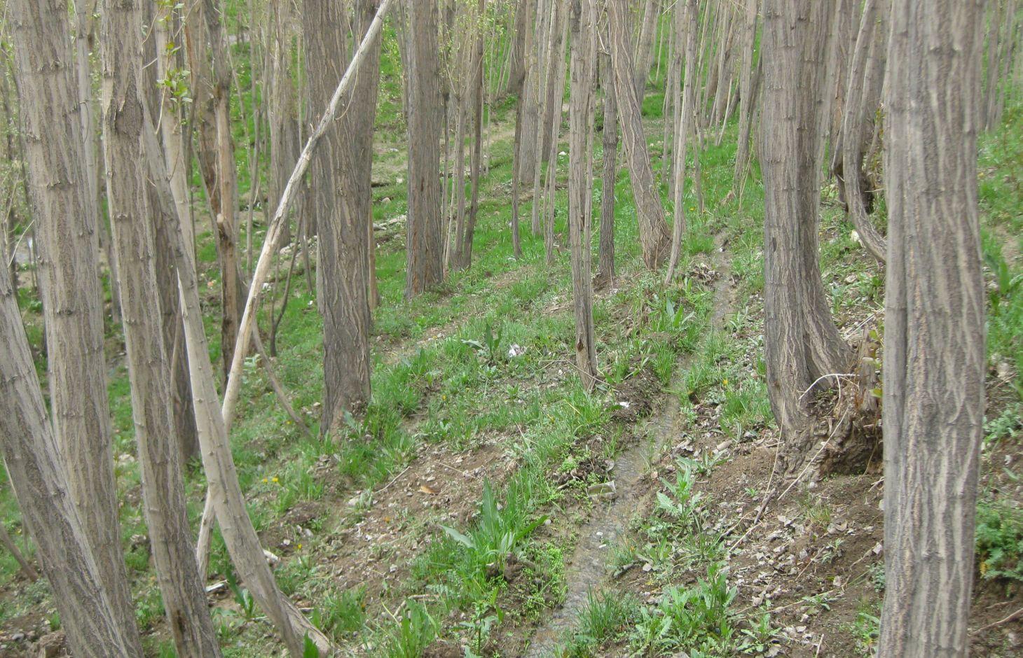
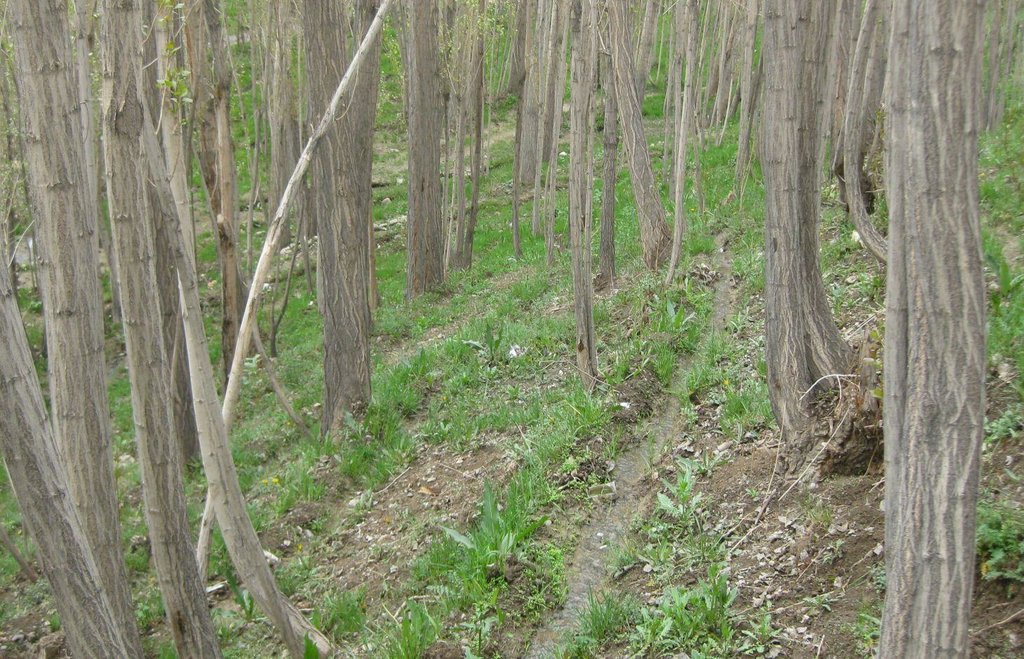
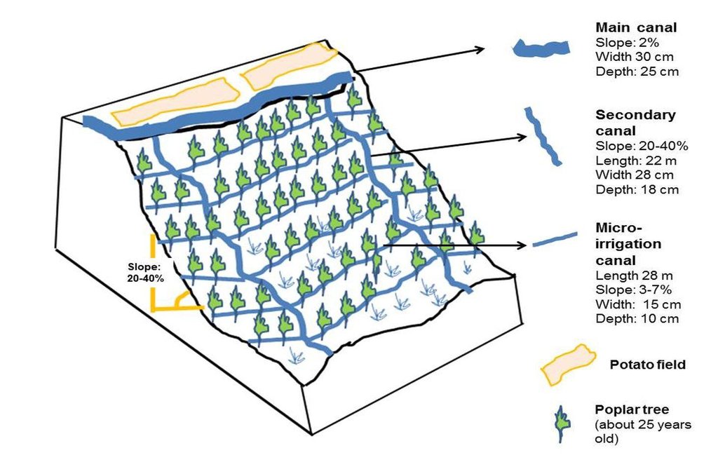
The technology consists of a network of main irrigation canal, secondary canals from which water is conveyed to sloping micro irrigation canals. The water reaches to the roots of each tree through infiltration/seepage.
The main canal has about 2% gradient and the micro-channels from 2-7% gradient. The slope of the site ranges between 20-40%. A micro irrigation canal is 28 m long, 15 cm wide and 10 cm deep. While the cross section remains same, the length can differ according to the land size.
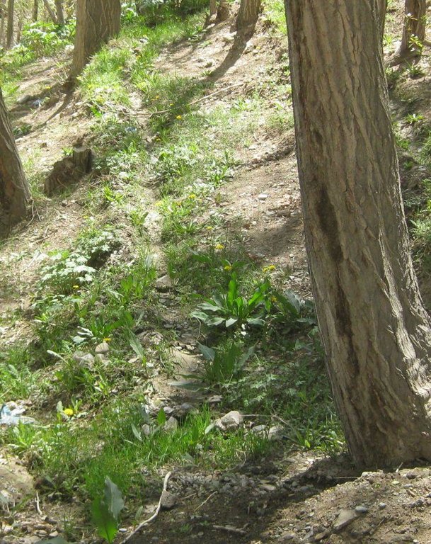
The site was originally a degraded site with gravel soil. According to the land user, the site was not at all suitable for agriculture due to soil degradation and bad water shortage possibilities. Approximately 25 years after the plantation of poplar trees, the site's physical and biological conditions of the slope have improved due to the establishment of poplar trees. The poplar trees can be used for timber for construction and firewood. The poplar timber has good market in Bamyan and can fetch up to 35 USD per tree.
The micro-irrigation systems, which help establishing poplar plantations, contribute to multiple benefits for the land user's family and also the environment. As the poplar plantations are irrigated, their growth increases and their mortality, due to water shortage, is reduced.
As a result of re-vegetating the relatively steep slope, soil erosion from the site has reduced and the fertility of the soil has improved. Improved soil moisture and fertility has also helped in establishment of a good ground canopy. Many birds visit the site for shelter. The plantation has reached its harvesting stage and the land user is planning to cut the trees for sale, expecting an income of about 10,500 USD from the site.
A close look at this technology shows that the system works well and that it is easily managed by the land user. Some minor improvements, such as reducing the slope gradient of the micro-irrigation canals for reducing canal erosion, construction of pits to capture sediments at the drainage points and planting suitable grasses with good roots along the canal bunds could make the system more effective and sustainable. The measures could also help in reducing the sensitivity of the micro-irrigation canals towards intense rainfall.
The farmers are applying this SLM technology without any external financial or technical support and there is growing trend towards spontaneous adoption. According to the land user's estimate, of about 400 families in his village, 80 families have applied the technology
The basic purpose of the micro-irrigation system is to supply irrigation water to the poplar trees for reducing plant mortality and increasing plant growth.
The main establishment activities include layout of the micro canals across the sloping land using shovels and pick axe without use of any alignment equipment. Approximately 150 persons-days/ha were employed for constructing the micro-irrigation canals and 5 person-days/ha sufficed for on-site maintenance works. About 970 USD/ha was spent on the construction and most of the cost for labour was covered by the family of the owner.
The site is owned by a land user with clear land use rights. The water rights are common and organized as there is a traditional social water management institution (Mirab), which ensures an equitable distribution of irrigation water to all the farmers taking water from the main canal. A command area on a turn-by-turn basis exists. Water users pay service fees to the Mirab mostly in kind. The land users mentioned that they give about 14 kg of wheat and/or potato each year to the Mirab for this site. The land user has to also participate in main canal repair works on a voluntary basis. Bamyan Centre receives about 230 mm rainfall per year. Most of the rain falls in the months of April and May. Winters are severe with temperatures falling below minus 20 degrees. The area receives snowfall up to 180 cm per year in normal years. Bamyan center has an arid and temperate climate with one main growing season of about 6 months, which is from April to September. The plantation site is located at an altitude of about 2300 m. It is north-facing slope with a soil depth of about 30-50 cm. The soil is sandy loam with a medium soil fertility.
2.3 Photos of the Technology
2.5 Country/ region/ locations where the Technology has been applied and which are covered by this assessment
Country:
Afghanistan
Region/ State/ Province:
Bamyan
Further specification of location:
Bamyan center
2.6 Date of implementation
If precise year is not known, indicate approximate date:
- 10-50 years ago
2.7 Introduction of the Technology
Specify how the Technology was introduced:
- through land users' innovation
Comments (type of project, etc.):
The technology is being applied on the site since about 25 years.
3. Classification of the SLM Technology
3.1 Main purpose(s) of the Technology
- improve production
3.2 Current land use type(s) where the Technology is applied

Forest/ woodlands
(Semi-)natural forests/ woodlands:
- Selective felling
Tree plantation, afforestation:
- Monoculture local variety
Products and services:
- Timber
- Fuelwood
Comments:
Major land use problems (compiler’s opinion): Gravely site, shortage of water for irrigation, sloping land affected by soil erosion. Heavy shrub harvesting for firewood and overgrazing on common/rangeland leading to land degradation.
Major land use problems (land users’ perception): Sloping land with sandy soil unsuitable for agriculture.
Plantation forestry: Plantation of poplar trees (mono culture)
Problems / comments regarding forest use: Land users do selective felling when they need cash. The trees are lopped for fuel wood.
Future (final) land use (after implementation of SLM Technology): Forests / woodlands: Fp: Plantations, afforestations
3.3 Further information about land use
Number of growing seasons per year:
- 1
Specify:
Longest growing period in days: 170, Longest growing period from month to month: April to September in the valley bottom
3.4 SLM group to which the Technology belongs
- irrigation management (incl. water supply, drainage)
3.5 Spread of the Technology
Specify the spread of the Technology:
- evenly spread over an area
If the Technology is evenly spread over an area, indicate approximate area covered:
- 0.1-1 km2
Comments:
Total area covered by the SLM Technology is 0.16 m2.
3.6 SLM measures comprising the Technology

structural measures
- S3: Graded ditches, channels, waterways
3.7 Main types of land degradation addressed by the Technology

biological degradation
- Bc: reduction of vegetation cover

water degradation
- Ha: aridification
Comments:
Main causes of degradation: over-exploitation of vegetation for domestic use (Particulary for firewood), overgrazing (Mainly by sheep and goats), population pressure, inputs and infrastructure: (roads, markets, distribution of water points, other, …) (Lack of irrigation water), governance / institutional (Specifically in the case of common lands)
Secondary causes of degradation: droughts
3.8 Prevention, reduction, or restoration of land degradation
Specify the goal of the Technology with regard to land degradation:
- reduce land degradation
4. Technical specifications, implementation activities, inputs, and costs
4.1 Technical drawing of the Technology
4.2 Technical specifications/ explanations of technical drawing
Technical specifications of micro-irrigation system for poplar plantation. The system comprises main canal, secondary canals and micro irrigation canals which receive water from and drain into secondary canals.
Location: Tape Chauni. Bamyan Centre
Date: 10 May 2014
Technical knowledge required for field staff / advisors: low
Technical knowledge required for land users: low
Main technical functions: water harvesting / increase water supply
Secondary technical functions: increase of biomass (quantity)
Vertical interval between structures (m): 0.22-0.6
Spacing between structures (m): 1.8-2
Depth of ditches/pits/dams (m): 0.1
Width of ditches/pits/dams (m): 0.15
Length of ditches/pits/dams (m): 0.28
Construction material (earth): Soil from the site is used for canal consturction
Slope (which determines the spacing indicated above): 20-40%
Lateral gradient along the structure: 3-7%
4.3 General information regarding the calculation of inputs and costs
other/ national currency (specify):
Afghani
Indicate exchange rate from USD to local currency (if relevant): 1 USD =:
57.0
Indicate average wage cost of hired labour per day:
70.00
4.4 Establishment activities
| Activity | Type of measure | Timing | |
|---|---|---|---|
| 1. | Construction of secondary and micro-irrigation canals | Structural | Spring |
4.5 Costs and inputs needed for establishment
| Specify input | Unit | Quantity | Costs per Unit | Total costs per input | % of costs borne by land users | |
|---|---|---|---|---|---|---|
| Labour | labour | ha | 1.0 | 921.0 | 921.0 | 100.0 |
| Equipment | tools | ha | 1.0 | 52.0 | 52.0 | 100.0 |
| Total costs for establishment of the Technology | 973.0 | |||||
Comments:
Duration of establishment phase: 0.25 month(s)
4.6 Maintenance/ recurrent activities
| Activity | Type of measure | Timing/ frequency | |
|---|---|---|---|
| 1. | Maintenance of canals | Structural | Spring/once per year |
4.7 Costs and inputs needed for maintenance/ recurrent activities (per year)
| Specify input | Unit | Quantity | Costs per Unit | Total costs per input | % of costs borne by land users | |
|---|---|---|---|---|---|---|
| Labour | labour | ha | 1.0 | 30.0 | 30.0 | 100.0 |
| Equipment | tools | ha | 1.0 | 52.0 | 52.0 | 100.0 |
| Total costs for maintenance of the Technology | 82.0 | |||||
Comments:
Machinery/ tools: Pick axe and shovels
The presented costs were calculated on the basis of the exisiting local labour rate and the currency exchange rate which may vary from one year to another. For instance in 2010/11, 1 USD was 50 Afghani.
The cost of payment to the Mirab (Water distributor appointed by the land users) is not included. According to the land user, the Mirabs receive about 700 kg wheat/year from all the land users who use the main canal.
4.8 Most important factors affecting the costs
Describe the most determinate factors affecting the costs:
Labour is the most determinate factor affecting the costs. All the work is done manually.
5. Natural and human environment
5.1 Climate
Annual rainfall
- < 250 mm
- 251-500 mm
- 501-750 mm
- 751-1,000 mm
- 1,001-1,500 mm
- 1,501-2,000 mm
- 2,001-3,000 mm
- 3,001-4,000 mm
- > 4,000 mm
Specifications/ comments on rainfall:
Most rainfall is in May. According to provincial agriculture department, Bamyan centre receives about 230 mm rain a year
Agro-climatic zone
- semi-arid
Thermal climate class: temperate. Winter temperatures can go below minus 20 degree C and maximum in summer up to 34 degree C
5.2 Topography
Slopes on average:
- flat (0-2%)
- gentle (3-5%)
- moderate (6-10%)
- rolling (11-15%)
- hilly (16-30%)
- steep (31-60%)
- very steep (>60%)
Landforms:
- plateau/plains
- ridges
- mountain slopes
- hill slopes
- footslopes
- valley floors
Altitudinal zone:
- 0-100 m a.s.l.
- 101-500 m a.s.l.
- 501-1,000 m a.s.l.
- 1,001-1,500 m a.s.l.
- 1,501-2,000 m a.s.l.
- 2,001-2,500 m a.s.l.
- 2,501-3,000 m a.s.l.
- 3,001-4,000 m a.s.l.
- > 4,000 m a.s.l.
5.3 Soils
Soil depth on average:
- very shallow (0-20 cm)
- shallow (21-50 cm)
- moderately deep (51-80 cm)
- deep (81-120 cm)
- very deep (> 120 cm)
Soil texture (topsoil):
- coarse/ light (sandy)
- medium (loamy, silty)
Topsoil organic matter:
- medium (1-3%)
5.4 Water availability and quality
Ground water table:
5-50 m
Availability of surface water:
good
Water quality (untreated):
for agricultural use only (irrigation)
5.5 Biodiversity
Species diversity:
- medium
5.6 Characteristics of land users applying the Technology
Market orientation of production system:
- mixed (subsistence/ commercial
Off-farm income:
- 10-50% of all income
Relative level of wealth:
- average
Individuals or groups:
- individual/ household
Gender:
- men
Indicate other relevant characteristics of the land users:
Land users applying the Technology are mainly common / average land users
Difference in the involvement of women and men: Women are however involved in other agriculture works but at the plantation site, they are not involved at all. The land user has about 0.4 ha irrigated crop land used for potato and wheat cultivation on a rotation basis.
Population density: 10-50 persons/km2
Annual population growth: 2% - 3%
Off-farm income specification: The land user family is food secure from its own production for up to 6 months only. For food security for 12 months, they have to depend on other sources of off farm income. The agriculture land is not enough to meet all the family needs.
5.7 Average area of land owned or leased by land users applying the Technology
- < 0.5 ha
- 0.5-1 ha
- 1-2 ha
- 2-5 ha
- 5-15 ha
- 15-50 ha
- 50-100 ha
- 100-500 ha
- 500-1,000 ha
- 1,000-10,000 ha
- > 10,000 ha
Is this considered small-, medium- or large-scale (referring to local context)?
- small-scale
5.8 Land ownership, land use rights, and water use rights
Land ownership:
- individual, titled
Land use rights:
- leased
Water use rights:
- communal (organized)
Comments:
For water distribution, there is a traditional system called as Mirab which is applied for the plantations as well. The land user applying the plantation/micro-irrigation technique have to participate in main irrigation canal repair and cleaning works. The land user also has to pay in kind or cash to the Mirab for his services.
5.9 Access to services and infrastructure
health:
- poor
- moderate
- good
education:
- poor
- moderate
- good
technical assistance:
- poor
- moderate
- good
employment (e.g. off-farm):
- poor
- moderate
- good
markets:
- poor
- moderate
- good
energy:
- poor
- moderate
- good
roads and transport:
- poor
- moderate
- good
drinking water and sanitation:
- poor
- moderate
- good
financial services:
- poor
- moderate
- good
6. Impacts and concluding statements
6.1 On-site impacts the Technology has shown
Socio-economic impacts
Production
fodder production
wood production
Comments/ specify:
Irrigation helps in Poplar establishment and growth
risk of production failure
Comments/ specify:
Important for reducing plant mortality
production area
Comments/ specify:
The area was degraded before
energy generation
Water availability and quality
irrigation water availability
Comments/ specify:
For plantations
Income and costs
farm income
Comments/ specify:
From sale of poplar trees but only in the long term
workload
Comments/ specify:
Irrigation needs more time and labour
Socio-cultural impacts
recreational opportunities
SLM/ land degradation knowledge
Comments/ specify:
Other land users see and learn
conflict mitigation
Fuel wood sufficiency
Comments/ specify:
Lopped branches are used for fuel wood
contribution to human well-being
Comments/ specify:
The technology contributes to increased household income in the long term and also towards increased production of fodder, fuel wood and timber.
Ecological impacts
Soil
soil moisture
soil organic matter/ below ground C
Comments/ specify:
Due to build of humus and ground cover
Biodiversity: vegetation, animals
biomass/ above ground C
Comments/ specify:
Due to plantations
plant diversity
Comments/ specify:
due to increased soil moisture
animal diversity
Comments/ specify:
habitat for birds
pest/ disease control
Climate and disaster risk reduction
wind velocity
Comments/ specify:
Due to plantations (indirect impact)
6.2 Off-site impacts the Technology has shown
buffering/ filtering capacity
Comments/ specify:
Due to plantations
wind transported sediments
Comments/ specify:
Plantations impact
damage on public/ private infrastructure
Comments/ specify:
Due to less sedimentation and runoff from the site
6.3 Exposure and sensitivity of the Technology to gradual climate change and climate-related extremes/ disasters (as perceived by land users)
Gradual climate change
Gradual climate change
| Season | Type of climatic change/ extreme | How does the Technology cope with it? | |
|---|---|---|---|
| annual temperature | increase | well |
Climate-related extremes (disasters)
Meteorological disasters
| How does the Technology cope with it? | |
|---|---|
| local rainstorm | not well |
Climatological disasters
| How does the Technology cope with it? | |
|---|---|
| drought | not well |
Hydrological disasters
| How does the Technology cope with it? | |
|---|---|
| general (river) flood | not well |
Comments:
Stabilize the technology with grasses and reduce the slope of the channels so that it is less sensitive to increase in rainfall intensities.
6.4 Cost-benefit analysis
How do the benefits compare with the establishment costs (from land users’ perspective)?
Short-term returns:
negative
Long-term returns:
very positive
How do the benefits compare with the maintenance/ recurrent costs (from land users' perspective)?
Short-term returns:
slightly negative
Long-term returns:
very positive
Comments:
The returns in the form of cash start coming after 10-12 years with this poplar variety following a selective felling and replanting approach.
6.5 Adoption of the Technology
Of all those who have adopted the Technology, how many have did so spontaneously, i.e. without receiving any material incentives/ payments?
- 90-100%
Comments:
100% of land user families have adopted the Technology without any external material support
80 land user families have adopted the Technology without any external material support
The total area under this plantation in the village is estimated to be 16 ha (80 jerib)
There is a small growing trend towards the adoption of the technology by communities and individuals in the area. Adoption depends on (and is hampered by) the availability of a reliable water source near the sites with potential for plantation and also about the land.
6.7 Strengths/ advantages/ opportunities of the Technology
| Strengths/ advantages/ opportunities in the land user’s view |
|---|
| The technology helps successful establishment of poplar trees and also natural grasses on sloping lands. |
| Strengths/ advantages/ opportunities in the compiler’s or other key resource person’s view |
|---|
| Micro-irrigation technology is important for the establishment and maintenance of poplar plantations. The technology is adapted for afforestation of sloping land. |
| The technology does not require much maintenance once the plantations are well established. A special attention need to be given to the secondary canals. |
| No external support for establishing or maintaining the technology. |
| The technology helps in improving the site's micro climate which leads to more plant and animal (bird) diversity. |
6.8 Weaknesses/ disadvantages/ risks of the Technology and ways of overcoming them
| Weaknesses/ disadvantages/ risks in the land user’s view | How can they be overcome? |
|---|---|
| There is no information available regarding the land user's view on the weaknesses of this technology. |
| Weaknesses/ disadvantages/ risks in the compiler’s or other key resource person’s view | How can they be overcome? |
|---|---|
| The canals break at some weak points. Also the slopes of the micro channels is more at many places leading to some soil erosion. | Proper alignment of micro-irrigation canals. |
| Rill and gully erosion due to rapid and uncontrolled flow of excessive drainage in secondary canals. | Plant grasses with robust root system along the canals. Strengthen points where water spills from the micro-irrigation canals into the secondary canals with vegetative measures and sediment pits. |
| Due to small sizes of the channels, irrigation needs more time and labour. | Improvements in micro irrigation canals will reduce this problem considering. Interested organisations could carry out action research on how to improve this system by also incorporating efficient water use measures. |
| The technology can be applied only when there is a reliable source of running water. | Action research on soil and water conservation techniques for plantations in areas where there is no easy access to irrigation water. |
7. References and links
7.1 Methods/ sources of information
- field visits, field surveys
- interviews with land users
Links and modules
Expand all Collapse allLinks
No links
Modules
No modules


