Terrasse [Morocco]
- Creation:
- Update:
- Compiler: Mohamed Sabir
- Editor: –
- Reviewers: Donia Mühlematter, Rima Mekdaschi Studer, Nicole Harari
Taghoulte
technologies_3208 - Morocco
View sections
Expand all Collapse all1. General information
1.2 Contact details of resource persons and institutions involved in the assessment and documentation of the Technology
land user:
Outrif Sidi Hammadi
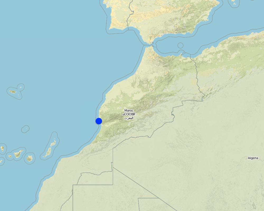
Douar Tazammourt, Commune Tamri, Province Agadir
Morocco
SLM specialist:
Name of project which facilitated the documentation/ evaluation of the Technology (if relevant)
Decision Support for Mainstreaming and Scaling out Sustainable Land Management (GEF-FAO / DS-SLM)Name of the institution(s) which facilitated the documentation/ evaluation of the Technology (if relevant)
Royaume du Maroc, Haut Commissariat aux Eaux et Forêts et à la Lutte Contre la Désertification (Royaume du Maroc) - Morocco1.3 Conditions regarding the use of data documented through WOCAT
When were the data compiled (in the field)?
24/01/2017
The compiler and key resource person(s) accept the conditions regarding the use of data documented through WOCAT:
Ja
1.4 Declaration on sustainability of the described Technology
Is the Technology described here problematic with regard to land degradation, so that it cannot be declared a sustainable land management technology?
Nee
2. Description of the SLM Technology
2.1 Short description of the Technology
Definition of the Technology:
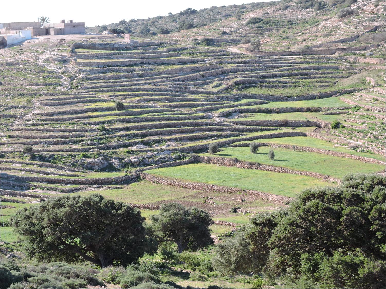
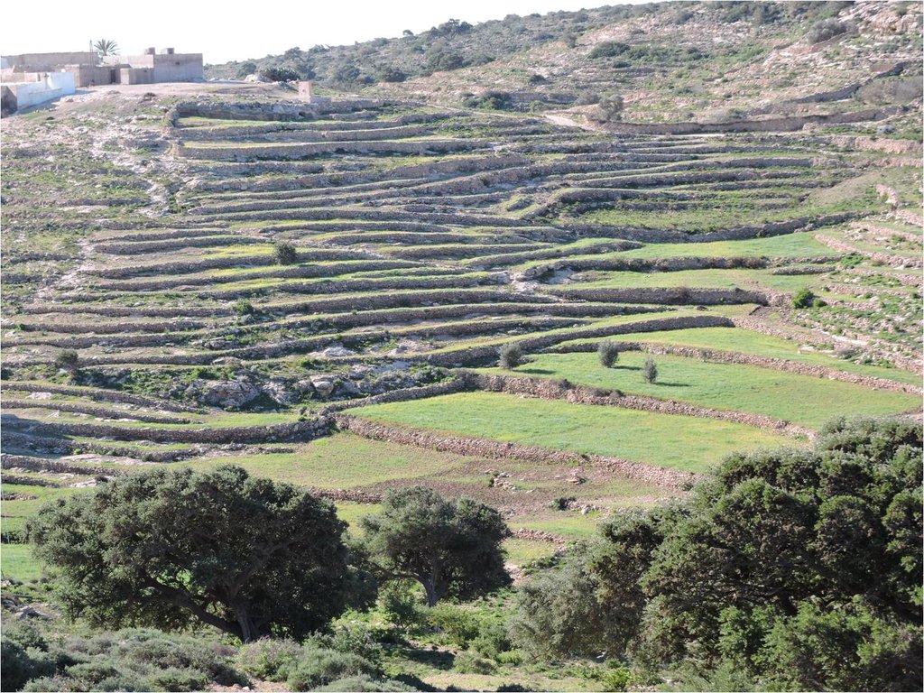
La terrasse correspond à une cassure de la pente du versant par la construction de murets, tallus ou de gradins. Elle permet de recueillir et infiltrer les eaux de pluie et par conséquent réduire le ruissellement et l'érosion des sols et améliorer le bilan hydrique du sol.
2.2 Detailed description of the Technology
Description:
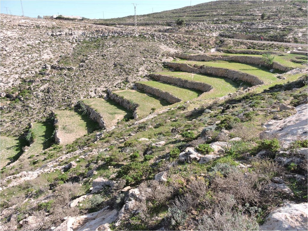
Les terrasses sont construites sur des versants à pente <60%, à substrats meubles faciles à travailler et à climat aride et semi aride. Elles sont souvent proches des douars pour faciliter le travail et le gardienage. Elles consistent à la cassure de la pente par des murets, talus et gradins. Elles sont de hauteur 1 à 2 m, d'épaisseur 80 cm à la base et 50 cm à la tête avec un fruit vers l'intérieur. La longueur peut aller de quelques m à plusieurs centaines de m (5-200m). La largeur du gradin est variable selon la pente, de 50cm sur pente forte à 10m sur pente faible. Le gradin a une légère pente vers le versant. Les murets ou les tallus sont souvent renforcés par de la végétation naturelle (arbustes fourragers) ou plantée (arbres fruitiers).
Les terrasses cassent la pente du versant, augmentent l'infiltration de l'eau de pluie, réduisent le ruissellement et les pertes en terres et accumulent les sédiments sur le gradin. Le bilan hydrique et la fertilité du sol sont améliorés. Le travail du sol est plus facile. La productivité de la terres est améliorée, notamment en fourrage et en grain (céréales).
Les murets sont construits progressivement à partir des pierres collectées sur la terrasse. Ils sont renforcés par les herbes (fourrage), les arbustes et les arbres à usage multiples (fourrage, fruits, bois). Les murets et talus sont entretenus avant et après chaque saison pluvieuse (hiver: octobre-janvier). Elles sont amendées à chaque début de compagne agricole (octobre) par du fumier produit par le cheptel de l'exploitation.
Les terrasses augmentent la productivité des terres (amélioration du bilan hydrique) en améliorant l'infiltration de l'eau, réduisent l'érosion et conservant la fertilité des sols. Le revenu de l'exploitation se trouve amélioré.
A chaque fois que le terrain le permet, les paysans en construisent parceque ces aménagements augmentent la productivité la terre. Cependant, elles nécessitent des entretines réguliers et donc beaucoup de main d'oeuvre.
2.3 Photos of the Technology
2.5 Country/ region/ locations where the Technology has been applied and which are covered by this assessment
Country:
Morocco
Region/ State/ Province:
Province Agadir-Ida Ou Tanane
Further specification of location:
Commune de Tamri
Map
×2.6 Date of implementation
If precise year is not known, indicate approximate date:
- more than 50 years ago (traditional)
2.7 Introduction of the Technology
Specify how the Technology was introduced:
- as part of a traditional system (> 50 years)
3. Classification of the SLM Technology
3.1 Main purpose(s) of the Technology
- improve production
- reduce, prevent, restore land degradation
- conserve ecosystem
- protect a watershed/ downstream areas – in combination with other Technologies
- preserve/ improve biodiversity
- reduce risk of disasters
- adapt to climate change/ extremes and its impacts
- mitigate climate change and its impacts
- create beneficial economic impact
3.2 Current land use type(s) where the Technology is applied

Cropland
- Annual cropping
- Tree and shrub cropping
Main crops (cash and food crops):
Céréales: orge, blé dur à usage domestique.

Mixed (crops/ grazing/ trees), incl. agroforestry
- Agroforestry
Main products/ services:
grain, paille, olive, noix d'argan.
3.3 Further information about land use
Water supply for the land on which the Technology is applied:
- rainfed
Number of growing seasons per year:
- 1
3.4 SLM group to which the Technology belongs
- agroforestry
- cross-slope measure
- water harvesting
3.5 Spread of the Technology
Specify the spread of the Technology:
- evenly spread over an area
If the Technology is evenly spread over an area, indicate approximate area covered:
- 10-100 km2
3.6 SLM measures comprising the Technology

agronomic measures
- A1: Vegetation/ soil cover
- A2: Organic matter/ soil fertility
- A3: Soil surface treatment

vegetative measures
- V1: Tree and shrub cover
- V2: Grasses and perennial herbaceous plants

structural measures
- S1: Terraces
- S2: Bunds, banks
- S6: Walls, barriers, palisades, fences
3.7 Main types of land degradation addressed by the Technology

soil erosion by water
- Wt: loss of topsoil/ surface erosion
- Wg: gully erosion/ gullying

chemical soil deterioration
- Cn: fertility decline and reduced organic matter content (not caused by erosion)
3.8 Prevention, reduction, or restoration of land degradation
Specify the goal of the Technology with regard to land degradation:
- prevent land degradation
- reduce land degradation
4. Technical specifications, implementation activities, inputs, and costs
4.1 Technical drawing of the Technology
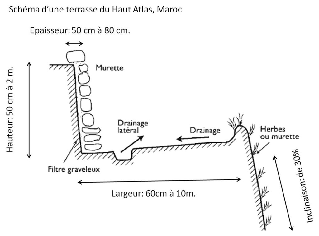
4.2 Technical specifications/ explanations of technical drawing
- Murette:
Hauteur: 50 cm à 2 m; Epaisseur: 80 cm à la base et 50 cm à la tête;
Fruit (inclinaison): de 30%;
Espacement: de 60 cm à 10 m;
- Gradin:
Largeur: 60 cm à 10 m (sur pente faible);
Longueur: 4 à 200 m.
4.3 General information regarding the calculation of inputs and costs
Specify how costs and inputs were calculated:
- per Technology unit
Specify unit:
ligne de pierre
Specify volume, length, etc. (if relevant):
de 50 m.
other/ national currency (specify):
Dirham marocain MAD
Indicate exchange rate from USD to local currency (if relevant): 1 USD =:
9.64971
Indicate average wage cost of hired labour per day:
70 MAD
4.4 Establishment activities
| Activity | Type of measure | Timing | |
|---|---|---|---|
| 1. | Collecte des pierres | Structural | Toute l'année |
| 2. | Transport des pierres | Structural | Automne |
| 3. | Construction des murets | Structural | Automne |
| 4. | Apport de la terre fine (remblais) | Structural | Automne |
| 5. | Terrassement | Structural | Automne |
4.5 Costs and inputs needed for establishment
| Specify input | Unit | Quantity | Costs per Unit | Total costs per input | % of costs borne by land users | |
|---|---|---|---|---|---|---|
| Labour | Ouvrier | Jour-personne | 50.0 | 70.0 | 3500.0 | 100.0 |
| Labour | Ouvrier qualifié (Maâlam) | Jour-personne | 10.0 | 120.0 | 1200.0 | 100.0 |
| Equipment | Pioches | Pioche | 5.0 | 120.0 | 600.0 | 100.0 |
| Equipment | Pelles | Pelle | 5.0 | 120.0 | 600.0 | 100.0 |
| Total costs for establishment of the Technology | 5900.0 | |||||
Comments:
Parfois, dans les villages les pyasans réalisent des ouvrages lourds (demandant beaucoup de main d'oeuvre) en solidarité dans le cadre d'un travail communautaire appelé "Twiza".
4.6 Maintenance/ recurrent activities
| Activity | Type of measure | Timing/ frequency | |
|---|---|---|---|
| 1. | Réhabilitation des murets et remises en place des pierres qui tombent du muret site aux événements pluvieux intenses. | Structural | Chaque saison de culture |
| 2. | Réhaussement des murets après atterissement des sédiments. | Structural | Chaque saison de culture |
4.7 Costs and inputs needed for maintenance/ recurrent activities (per year)
| Specify input | Unit | Quantity | Costs per Unit | Total costs per input | % of costs borne by land users | |
|---|---|---|---|---|---|---|
| Labour | Ouvrier | Jour - Personne | 1.0 | 70.0 | 70.0 | |
| Labour | Ouvrier qualifié (Maâlam) | Jour - Personne | 1.0 | 120.0 | 120.0 | 100.0 |
| Total costs for maintenance of the Technology | 190.0 | |||||
4.8 Most important factors affecting the costs
Describe the most determinate factors affecting the costs:
La main d'oeuvre (soit salariée, soit familiale) est le facteur le plus important.
La terre et les pierres sont disponibles soit sur le versant, soit dans l'oued.
Les ouvriers les ramassent et les compilent pour construire la murette et le gradin.
5. Natural and human environment
5.1 Climate
Annual rainfall
- < 250 mm
- 251-500 mm
- 501-750 mm
- 751-1,000 mm
- 1,001-1,500 mm
- 1,501-2,000 mm
- 2,001-3,000 mm
- 3,001-4,000 mm
- > 4,000 mm
Specify average annual rainfall (if known), in mm:
400.00
Specifications/ comments on rainfall:
Pluies irregulières dans le temps et dans l'espace.
Saison pluvieuse: hiver (novembre - février),
Saison sèche: été, 5 à 7 mois.
Orages en été (juillet-août), début automne (septembre).
Indicate the name of the reference meteorological station considered:
Agadir
Agro-climatic zone
- semi-arid
Climat méditerranéen.
5.2 Topography
Slopes on average:
- flat (0-2%)
- gentle (3-5%)
- moderate (6-10%)
- rolling (11-15%)
- hilly (16-30%)
- steep (31-60%)
- very steep (>60%)
Landforms:
- plateau/plains
- ridges
- mountain slopes
- hill slopes
- footslopes
- valley floors
Altitudinal zone:
- 0-100 m a.s.l.
- 101-500 m a.s.l.
- 501-1,000 m a.s.l.
- 1,001-1,500 m a.s.l.
- 1,501-2,000 m a.s.l.
- 2,001-2,500 m a.s.l.
- 2,501-3,000 m a.s.l.
- 3,001-4,000 m a.s.l.
- > 4,000 m a.s.l.
Indicate if the Technology is specifically applied in:
- concave situations
5.3 Soils
Soil depth on average:
- very shallow (0-20 cm)
- shallow (21-50 cm)
- moderately deep (51-80 cm)
- deep (81-120 cm)
- very deep (> 120 cm)
Soil texture (topsoil):
- coarse/ light (sandy)
- medium (loamy, silty)
Soil texture (> 20 cm below surface):
- coarse/ light (sandy)
- medium (loamy, silty)
Topsoil organic matter:
- low (<1%)
If available, attach full soil description or specify the available information, e.g. soil type, soil PH/ acidity, Cation Exchange Capacity, nitrogen, salinity etc.
Sol peu évolué.
pH = 7,5
5.4 Water availability and quality
Ground water table:
> 50 m
Availability of surface water:
poor/ none
Water quality (untreated):
good drinking water
Is water salinity a problem?
Nee
Is flooding of the area occurring?
Nee
Comments and further specifications on water quality and quantity:
En été, les nappes sont très profondes (100 m). Elles se rechargent en hiver. Mais la quantité n'est pas suffisante.
5.5 Biodiversity
Species diversity:
- medium
Habitat diversity:
- medium
5.6 Characteristics of land users applying the Technology
Sedentary or nomadic:
- Sedentary
Market orientation of production system:
- subsistence (self-supply)
Off-farm income:
- less than 10% of all income
- 10-50% of all income
Relative level of wealth:
- poor
- average
Individuals or groups:
- individual/ household
- groups/ community
Level of mechanization:
- manual work
- animal traction
Gender:
- men
Age of land users:
- middle-aged
- elderly
5.7 Average area of land owned or leased by land users applying the Technology
- < 0.5 ha
- 0.5-1 ha
- 1-2 ha
- 2-5 ha
- 5-15 ha
- 15-50 ha
- 50-100 ha
- 100-500 ha
- 500-1,000 ha
- 1,000-10,000 ha
- > 10,000 ha
Is this considered small-, medium- or large-scale (referring to local context)?
- medium-scale
5.8 Land ownership, land use rights, and water use rights
Land ownership:
- individual, not titled
- individual, titled
Land use rights:
- open access (unorganized)
Water use rights:
- communal (organized)
5.9 Access to services and infrastructure
health:
- poor
- moderate
- good
education:
- poor
- moderate
- good
technical assistance:
- poor
- moderate
- good
employment (e.g. off-farm):
- poor
- moderate
- good
markets:
- poor
- moderate
- good
energy:
- poor
- moderate
- good
roads and transport:
- poor
- moderate
- good
drinking water and sanitation:
- poor
- moderate
- good
financial services:
- poor
- moderate
- good
6. Impacts and concluding statements
6.1 On-site impacts the Technology has shown
Socio-economic impacts
Production
crop production
Quantity before SLM:
2 q/ha/an
Quantity after SLM:
5 q/ha/an
Comments/ specify:
Le bilan hydrique amélioré engendre une augmentation de la productivité.
crop quality
Quantity before SLM:
1 q/ha/an
Quantity after SLM:
4 q/ha/an
fodder production
fodder quality
animal production
Comments/ specify:
Les animaux sont mieux alimentés.
wood production
risk of production failure
product diversity
production area
land management
Comments/ specify:
La gestion de la terre est mieux organisée.
Income and costs
expenses on agricultural inputs
farm income
workload
Socio-cultural impacts
food security/ self-sufficiency
SLM/ land degradation knowledge
Ecological impacts
Water cycle/ runoff
water quantity
harvesting/ collection of water
surface runoff
Soil
soil moisture
soil loss
soil accumulation
soil organic matter/ below ground C
Biodiversity: vegetation, animals
biomass/ above ground C
animal diversity
beneficial species
habitat diversity
Climate and disaster risk reduction
flood impacts
drought impacts
impacts of cyclones, rain storms
6.2 Off-site impacts the Technology has shown
downstream flooding
damage on public/ private infrastructure
6.3 Exposure and sensitivity of the Technology to gradual climate change and climate-related extremes/ disasters (as perceived by land users)
Gradual climate change
Gradual climate change
| Season | Type of climatic change/ extreme | How does the Technology cope with it? | |
|---|---|---|---|
| annual temperature | not known | ||
| seasonal rainfall | summer | decrease | well |
Climate-related extremes (disasters)
Meteorological disasters
| How does the Technology cope with it? | |
|---|---|
| local rainstorm | well |
Climatological disasters
| How does the Technology cope with it? | |
|---|---|
| drought | well |
Other climate-related consequences
Other climate-related consequences
| How does the Technology cope with it? | |
|---|---|
| reduced growing period | well |
6.4 Cost-benefit analysis
How do the benefits compare with the establishment costs (from land users’ perspective)?
Short-term returns:
very positive
Long-term returns:
very positive
How do the benefits compare with the maintenance/ recurrent costs (from land users' perspective)?
Short-term returns:
very positive
Long-term returns:
very positive
6.5 Adoption of the Technology
- more than 50%
If available, quantify (no. of households and/ or area covered):
Tous les ménages ayant de la terre sur pente.
Of all those who have adopted the Technology, how many have did so spontaneously, i.e. without receiving any material incentives/ payments?
- 90-100%
6.6 Adaptation
Has the Technology been modified recently to adapt to changing conditions?
Nee
6.7 Strengths/ advantages/ opportunities of the Technology
| Strengths/ advantages/ opportunities in the land user’s view |
|---|
| Améliore le bilan hydrique du sol. |
| Réduit les pertes en sol. |
| Augmente les rendements des cultures. |
| Strengths/ advantages/ opportunities in the compiler’s or other key resource person’s view |
|---|
| Le bilan hydrique est nettement amélioré avec les terrasses. |
| Améliore la fertilité des sols et donc leur productivité. |
| Améliore le paysage (patrimoine national). |
6.8 Weaknesses/ disadvantages/ risks of the Technology and ways of overcoming them
| Weaknesses/ disadvantages/ risks in the land user’s view | How can they be overcome? |
|---|---|
| Entretien indispensable au moins une fois par an après la saison des pluies. |
Comblement des creusements par des pierres et de la terre. Remise en place des pierres tombées. |
| Accès aux parcelles agricoles. | Des chemins étroits sont laissés entre les terrasses. |
| Weaknesses/ disadvantages/ risks in the compiler’s or other key resource person’s view | How can they be overcome? |
|---|---|
| Nécessité d'entretien régulier (après les pluies). | |
| Réduisent la circulation des animaux et des outils. |
7. References and links
7.1 Methods/ sources of information
- field visits, field surveys
Plusieurs journées de prospection.
- interviews with land users
Plus de trente paysans.
- interviews with SLM specialists/ experts
3 spécialistes.
7.2 References to available publications
Title, author, year, ISBN:
Roose E., Sabir M. et Laouina A. Adaptation des stratégies paysannes de Gestion Conservatoire de l’Eau et des Sols (GCES) aux conditions agro-écologiques du Maroc. (Manuel de GCES du Maroc). Edition IRD 2010.
Available from where? Costs?
http://horizon.documentation.ird.fr/exl-doc/ pleins_textes/divers12-09/010054911.pdf
Title, author, year, ISBN:
Roose E. et Sabir M. Restauration des basses terrasses rasées par les torrents dans le Haut Atlas (Maroc). In Roose E. (Edit). Restauration de la productivité des sols tropicaux et méditerranéens-Contribution à l'agroécologie. Editions IRD, 2017.
Available from where? Costs?
http://horizon.documentation.ird.fr/exl-doc/ pleins_textes/divers16-05/010064961.pdf
7.3 Links to relevant information which is available online
Title/ description:
Roose E., Sabir M. et Laouina A. Adaptation des stratégies paysannes de Gestion Conservatoire de l’Eau et des Sols (GCES) aux conditions agro-écologiques du Maroc. (Manuel de GCES du Maroc). Edition IRD 2010.
URL:
http://horizon.documentation.ird.fr/exl-doc/ pleins_textes/divers12-09/010054911.pdf
Links and modules
Expand all Collapse allLinks
No links
Modules
No modules


