Soil Conservation Through Bench Terrace Technology in Highly Degradable Hilly Slopy Areas of Bangladesh [Bangladesh]
- Creation:
- Update:
- Compiler: Md Babul Hossain
- Editor: –
- Reviewer: Udo Höggel
"Dhap Poddoti" for soil erosion control in the highly degradable Chattagram Hill tract area of Bangladesh
technologies_4284 - Bangladesh
View sections
Expand all Collapse all1. General information
1.2 Contact details of resource persons and institutions involved in the assessment and documentation of the Technology
SLM specialist:
Islam Mahabubul
Soil Resource Development Institute
Bangladesh
land user:
Chakma Ushalaya
Soil Resource Development Institute
Bangladesh
co-compiler:
Md Zahid Ameer
Soil Resource Development Institute
Bangladesh
Name of the institution(s) which facilitated the documentation/ evaluation of the Technology (if relevant)
Soil Resource Development Institute (SRDI) (Soil Resource Development Institute (SRDI)) - Bangladesh1.3 Conditions regarding the use of data documented through WOCAT
The compiler and key resource person(s) accept the conditions regarding the use of data documented through WOCAT:
Ja
1.4 Declaration on sustainability of the described Technology
Is the Technology described here problematic with regard to land degradation, so that it cannot be declared a sustainable land management technology?
Nee
Comments:
It is a very effective technology for soil conservation in hilly areas.
2. Description of the SLM Technology
2.1 Short description of the Technology
Definition of the Technology:
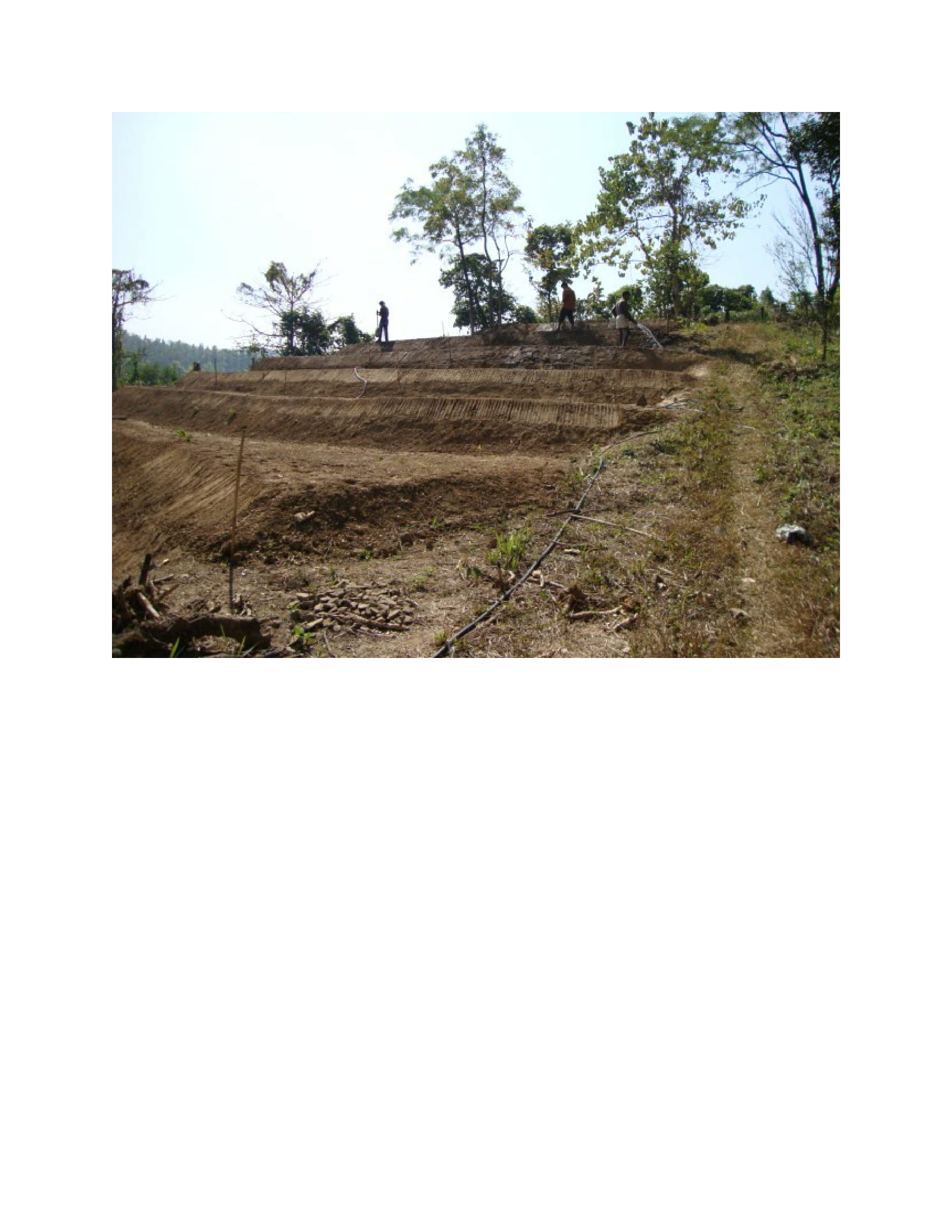
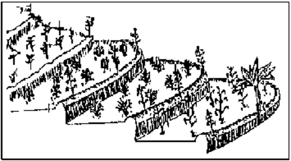
Bench terraces are a soil and water conservation measure used on sloping land with relatively deep soils to retain water and control erosion. They are normally constructed by cutting and filling to produce a series of level steps or benches. This allows water to infiltrate slowly into the soil. Bench terraces are reinforced by banks of soil or stone that block waterflow above the forward edges. This practice is typical for rice-based cropping systems.It is also helpful to increase the beauty of the land along with increasing the soil stability on these lands.
2.2 Detailed description of the Technology
Description:
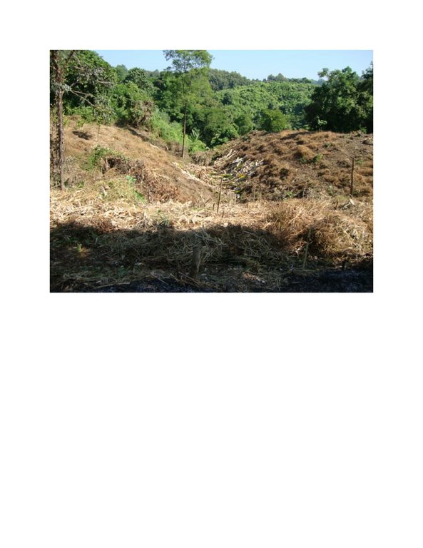
The Chittagong Hill Tracts (CHT) are undergoing deforestation and land degradation arising from environmentally unsuitable activities such as tobacco cultivation in sloping land, shifting cultivation and logging. Shifting cultivation, also known as slash-and-burn agriculture. The present shifting cultivation system with short fallow in the Chittagong Hill Tracts has accelerated erosion, land degradation, deforestation, and impoverishment of tribal people in CHT. If the present state of degradation continues, most of the areas under shifting cultivation will be severely degraded and future generations will face more difficulties to eke out their livelihoods on further degraded land. That land shows massive erosion impact as influenced by shifting cultivation (Jhum) at steep and continuously sloping lands.
To address the aforesaid constraints in hilly areas of CHT, the Soil Conservation and Watershed Management Centre (SCWMC) of the Soil Resource Development Institute (SRDI) has developed the "Bench Terrace" technology. In this technology, some bench like terraces are made on the slopy land of hills where the slope angle is more than 30 degree. The width of the terraces ranges from 2.5 to 3.0 metre. The height of the terraces is 0.6 metre to 1 metre. An embankment constructed at the outer rim of the terraces prevents run off and soil loss over the outer edge of the terrace during heavy rain in the monsoon. The length of such terraces depends on the topographical contexts within which the terraces are constructed. The technology has various benefits:
- To reduce the quantum of overland flow/sheet flow or runoff, and their velocity.
- To minimize the soil erosion.
- To conserve soil moisture.
- To conserve soil fertility and to facilitate farming operations such as ploughing, irrigation etc. on sloping land.
- To promote intensive land use, permanent agriculture and checking shifting cultivation on steep lands.
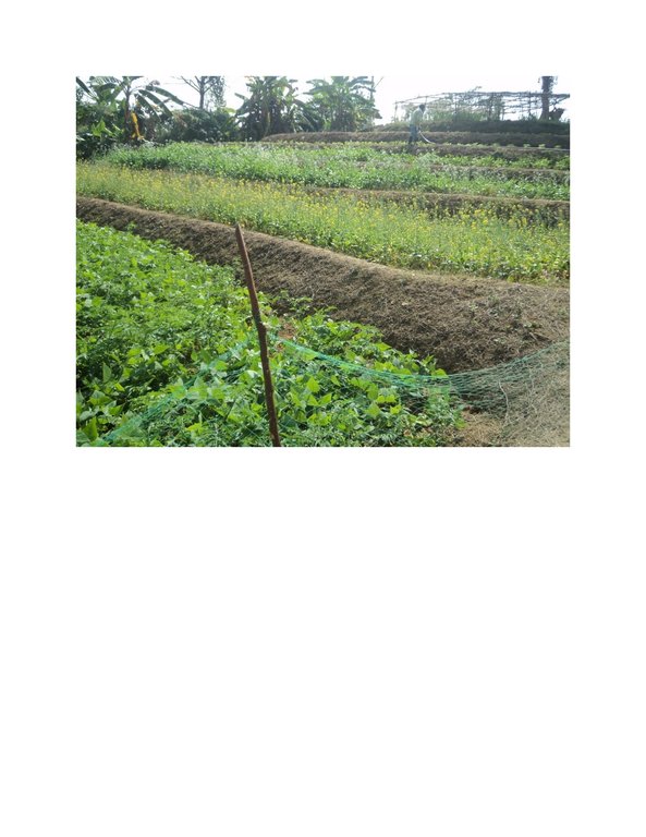
- Bench terraces support proper water management and fertilizers/manure application. They will also help in increasing cropping intensity within a stable farming system.
The hill dwellers, who are the owners of the land, are practicing the technology because it has established a permanent solution for crop production instead shifting cultivation. The technology contributes to a reduction in land slides, soil erosion and to increased farm income. Bench Terraces are widely being used in the hilly areas of India, Nepal, Srilanka, Tamilnadu etc.
.
2.3 Photos of the Technology
2.5 Country/ region/ locations where the Technology has been applied and which are covered by this assessment
Country:
Bangladesh
Region/ State/ Province:
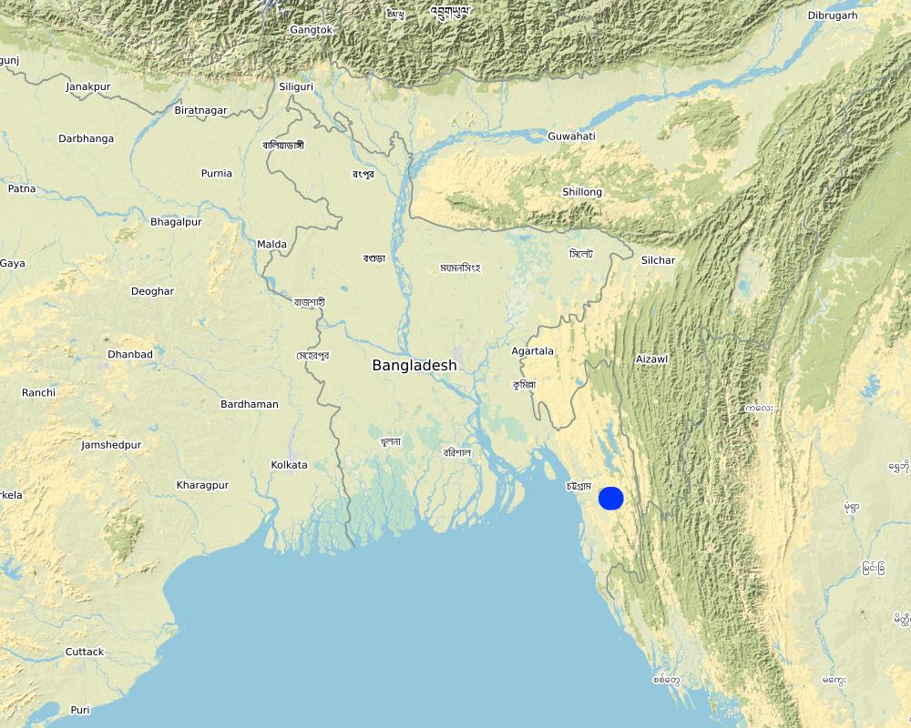
Bandarban
Further specification of location:
Its a region
Specify the spread of the Technology:
- evenly spread over an area
If precise area is not known, indicate approximate area covered:
- 10-100 km2
Is/are the technology site(s) located in a permanently protected area?
Nee
Comments:
This area is not under reserve forest area of Bangladesh forest department, instead it includes shifting cultivation areas of hill dwellers.
Map
×2.6 Date of implementation
If precise year is not known, indicate approximate date:
- less than 10 years ago (recently)
2.7 Introduction of the Technology
Specify how the Technology was introduced:
- during experiments/ research
Comments (type of project, etc.):
Soil conservation and watershed management centre of soil resource development institute(SRDI) has developed the technology through long term research trial in farmers field as well as in research station.
3. Classification of the SLM Technology
3.1 Main purpose(s) of the Technology
- improve production
- reduce, prevent, restore land degradation
- conserve ecosystem
- protect a watershed/ downstream areas – in combination with other Technologies
- reduce risk of disasters
- create beneficial economic impact
3.2 Current land use type(s) where the Technology is applied
Land use mixed within the same land unit:
Nee

Forest/ woodlands
- (Semi-)natural forests/ woodlands
(Semi-)natural forests/ woodlands: Specify management type:
- Shifting cultivation
- Non-wood forest use
Are the trees specified above deciduous or evergreen?
- mixed deciduous/ evergreen
Products and services:
- Fuelwood
3.3 Has land use changed due to the implementation of the Technology?
Has land use changed due to the implementation of the Technology?
- Yes (Please fill out the questions below with regard to the land use before implementation of the Technology)
Land use mixed within the same land unit:
Ja
Specify mixed land use (crops/ grazing/ trees):
- Agroforestry

Cropland
- Annual cropping
- Tree and shrub cropping
Annual cropping - Specify crops:
- vegetables - leafy vegetables (salads, cabbage, spinach, other)
Annual cropping system:
Continuous vegetables
Tree and shrub cropping - Specify crops:
- citrus
Is intercropping practiced?
Nee
Is crop rotation practiced?
Nee
Comments:
The land management and production system contains 3 cropping seasons per annum. The seasons are Rabi- Kharif1-Kharif-2.
3.4 Water supply
Water supply for the land on which the Technology is applied:
- mixed rainfed-irrigated
3.5 SLM group to which the Technology belongs
- agroforestry
- minimal soil disturbance
- cross-slope measure
3.6 SLM measures comprising the Technology

structural measures
- S1: Terraces
3.7 Main types of land degradation addressed by the Technology

soil erosion by water
- Wt: loss of topsoil/ surface erosion
- Wg: gully erosion/ gullying
3.8 Prevention, reduction, or restoration of land degradation
Specify the goal of the Technology with regard to land degradation:
- reduce land degradation
4. Technical specifications, implementation activities, inputs, and costs
4.1 Technical drawing of the Technology
Technical specifications (related to technical drawing):
According to the hill slope, the height, width (depth) and length of terrace can vary. Generally the width (depth) of a terrace is 2.5- 3 metre, the height is 1 metre and slope angle 10 to 15 degree. The contour is established by uplifting soil in a straight line and the wall is constructed by mud. The floor area is leveled and cultivated with spade or plough. Generally the floor area of a bench terrace is 40 square metres. An access path is kept open from one corner of the terrace.
The horizontal orientation of the terraces follow the contour line of the slope. That contour line is an imaginary line perpendicular to the sloping direction (uphill to downhill) of an area. The contour line runs horizontally along the slope of a farm.
Viewed from an opposite the face of the slope, all contour lines will appear horizontally. However, viewed from uphill, the lines may either be straight, curved like the outside of a sphere, or curved irregularly downward or upward depending on the presence of low- and high-lying surfaces on the face of the slope.
4.2 General information regarding the calculation of inputs and costs
Specify how costs and inputs were calculated:
- per Technology area
Indicate size and area unit:
1 acre
other/ national currency (specify):
Taka( Bangladeshi currency)
If relevant, indicate exchange rate from USD to local currency (e.g. 1 USD = 79.9 Brazilian Real): 1 USD =:
80.0
Indicate average wage cost of hired labour per day:
500 taka
4.3 Establishment activities
| Activity | Timing (season) | |
|---|---|---|
| 1. | Cleaning forest | Before making the terraces |
| 2. | Earth cutting | Before raining season |
| 3. | Making terraces | |
| 4. | Land preparation | every season |
| 5. | fertiliser application | every season |
| 6. | seed sowing | every season |
| 7. | Irrigation | 5 times per cropping season |
| 8. | Intercultural operation | occassionally |
| 9. | Reconstruction of terraces | Before rainy season |
4.4 Costs and inputs needed for establishment
| Specify input | Unit | Quantity | Costs per Unit | Total costs per input | % of costs borne by land users | |
|---|---|---|---|---|---|---|
| Labour | Cleaning forest | persons-per day | 5.0 | 500.0 | 2500.0 | 100.0 |
| Labour | Earth cutting | persons-per day | 4.0 | 500.0 | 2000.0 | 100.0 |
| Labour | Making terraces | persons-per day | 5.0 | 500.0 | 2500.0 | 100.0 |
| Labour | Land preparation | persons-per day | 3.0 | 500.0 | 1500.0 | 100.0 |
| Equipment | fertiliser application | persons-per day | 1.0 | 500.0 | 500.0 | 50.0 |
| Equipment | seed sowing | persons-per day | 2.0 | 500.0 | 1000.0 | 30.0 |
| Equipment | Irrigation | persons-per day | 3.0 | 500.0 | 1500.0 | 70.0 |
| Equipment | Intercultural operation | persons-per day | 4.0 | 500.0 | 2000.0 | 100.0 |
| Equipment | Machine operated cleaning tools | Number | 1.0 | 4000.0 | 4000.0 | 50.0 |
| Equipment | spade | Number | 5.0 | 300.0 | 1500.0 | 100.0 |
| Equipment | mower | Number | 1.0 | 2000.0 | 2000.0 | 100.0 |
| Equipment | sickle | Number | 5.0 | 200.0 | 1000.0 | 100.0 |
| Plant material | Tape | Piece | 2.0 | 100.0 | 200.0 | 100.0 |
| Plant material | rope | piece | 2.0 | 50.0 | 100.0 | 100.0 |
| Plant material | seed | Kg | 0.5 | 300.0 | 150.0 | |
| Plant material | seedlings | Number | 50.0 | 50.0 | 2500.0 | |
| Fertilizers and biocides | Nitrogen | Kg | 20.0 | 16.0 | 320.0 | 70.0 |
| Fertilizers and biocides | Phosphorus | Kg | 10.0 | 22.0 | 220.0 | 70.0 |
| Fertilizers and biocides | potassium | Kg | 15.0 | 30.0 | 450.0 | 70.0 |
| Fertilizers and biocides | Compost | Ton | 1.0 | 1000.0 | 1000.0 | 100.0 |
| Construction material | pesticide | Kg | 0.5 | 200.0 | 100.0 | 50.0 |
| Construction material | pipes | Number | 5.0 | 400.0 | 2000.0 | 50.0 |
| Total costs for establishment of the Technology | 29040.0 | |||||
| Total costs for establishment of the Technology in USD | 363.0 | |||||
If land user bore less than 100% of costs, indicate who covered the remaining costs:
Department of Agriculture Extension and other Government and non Government organisation
Comments:
The Government organisations always encourage the land owners to practice the technology by giving a portion of inputs.
4.5 Maintenance/ recurrent activities
| Activity | Timing/ frequency | |
|---|---|---|
| 1. | Reconstruction of terraces | Before rainy season |
4.6 Costs and inputs needed for maintenance/ recurrent activities (per year)
| Specify input | Unit | Quantity | Costs per Unit | Total costs per input | % of costs borne by land users | |
|---|---|---|---|---|---|---|
| Labour | Reconstruction of terraces | Persons-per day | 2.0 | 500.0 | 1000.0 | 80.0 |
| Total costs for maintenance of the Technology | 1000.0 | |||||
| Total costs for maintenance of the Technology in USD | 12.5 | |||||
4.7 Most important factors affecting the costs
Describe the most determinate factors affecting the costs:
Labour cost is the most important factor that affects the total cost.
5. Natural and human environment
5.1 Climate
Annual rainfall
- < 250 mm
- 251-500 mm
- 501-750 mm
- 751-1,000 mm
- 1,001-1,500 mm
- 1,501-2,000 mm
- 2,001-3,000 mm
- 3,001-4,000 mm
- > 4,000 mm
Agro-climatic zone
- sub-humid
Mean annual temperature 27 degree celcius
5.2 Topography
Slopes on average:
- flat (0-2%)
- gentle (3-5%)
- moderate (6-10%)
- rolling (11-15%)
- hilly (16-30%)
- steep (31-60%)
- very steep (>60%)
Landforms:
- plateau/plains
- ridges
- mountain slopes
- hill slopes
- footslopes
- valley floors
Altitudinal zone:
- 0-100 m a.s.l.
- 101-500 m a.s.l.
- 501-1,000 m a.s.l.
- 1,001-1,500 m a.s.l.
- 1,501-2,000 m a.s.l.
- 2,001-2,500 m a.s.l.
- 2,501-3,000 m a.s.l.
- 3,001-4,000 m a.s.l.
- > 4,000 m a.s.l.
Indicate if the Technology is specifically applied in:
- not relevant
5.3 Soils
Soil depth on average:
- very shallow (0-20 cm)
- shallow (21-50 cm)
- moderately deep (51-80 cm)
- deep (81-120 cm)
- very deep (> 120 cm)
Soil texture (topsoil):
- medium (loamy, silty)
Soil texture (> 20 cm below surface):
- medium (loamy, silty)
Topsoil organic matter:
- low (<1%)
If available, attach full soil description or specify the available information, e.g. soil type, soil PH/ acidity, Cation Exchange Capacity, nitrogen, salinity etc.
soils are clay loam to clay, soils are acidic in nature, nitrogen content in most cases low and presence of no salinity. Land type -very high
5.4 Water availability and quality
Ground water table:
> 50 m
Availability of surface water:
poor/ none
Water quality (untreated):
poor drinking water (treatment required)
Water quality refers to:
ground water
Is water salinity a problem?
Nee
Is flooding of the area occurring?
Nee
5.5 Biodiversity
Species diversity:
- medium
Habitat diversity:
- medium
5.6 Characteristics of land users applying the Technology
Sedentary or nomadic:
- Sedentary
Market orientation of production system:
- subsistence (self-supply)
Off-farm income:
- 10-50% of all income
Relative level of wealth:
- average
Individuals or groups:
- individual/ household
Level of mechanization:
- manual work
Gender:
- women
Age of land users:
- middle-aged
5.7 Average area of land used by land users applying the Technology
- < 0.5 ha
- 0.5-1 ha
- 1-2 ha
- 2-5 ha
- 5-15 ha
- 15-50 ha
- 50-100 ha
- 100-500 ha
- 500-1,000 ha
- 1,000-10,000 ha
- > 10,000 ha
Is this considered small-, medium- or large-scale (referring to local context)?
- small-scale
5.8 Land ownership, land use rights, and water use rights
Land ownership:
- individual, not titled
- individual, titled
Land use rights:
- individual
Water use rights:
- open access (unorganized)
Are land use rights based on a traditional legal system?
Ja
5.9 Access to services and infrastructure
health:
- poor
- moderate
- good
education:
- poor
- moderate
- good
technical assistance:
- poor
- moderate
- good
employment (e.g. off-farm):
- poor
- moderate
- good
markets:
- poor
- moderate
- good
energy:
- poor
- moderate
- good
roads and transport:
- poor
- moderate
- good
drinking water and sanitation:
- poor
- moderate
- good
financial services:
- poor
- moderate
- good
6. Impacts and concluding statements
6.1 On-site impacts the Technology has shown
Socio-economic impacts
Production
crop production
risk of production failure
production area
land management
Comments/ specify:
In hilly area , due to slopy land , it is difficult to manage because soil erosion is higher in rainy season, there are no structures to reduce soil erosion. But, due to the establishment of bench terraces, soil erosion in rainy season is significantly checked and long slopy stretches are interupted by a soil stabilising structure. In this way , land management is simplified.
Income and costs
expenses on agricultural inputs
farm income
diversity of income sources
economic disparities
workload
Socio-cultural impacts
food security/ self-sufficiency
health situation
land use/ water rights
cultural opportunities
recreational opportunities
Comments/ specify:
As the economic situation is improved through increased crop production due to this method, the land owners will beneift from new opportunities for recreational programmes.
community institutions
national institutions
SLM/ land degradation knowledge
conflict mitigation
situation of socially and economically disadvantaged groups
Ecological impacts
Soil
soil moisture
soil cover
soil loss
soil accumulation
nutrient cycling/ recharge
soil organic matter/ below ground C
acidity
Comments/ specify:
As the land owners use balanced fertiliser , with proper irrigation and other intercultural operations, so, soil acidity will reduce a little bit.
Biodiversity: vegetation, animals
Vegetation cover
biomass/ above ground C
plant diversity
animal diversity
Comments/ specify:
As planned cropping system is going to be established in bench terrace land management system, so soil flora and fauna will get a suitable environment to grow.
beneficial species
habitat diversity
pest/ disease control
Climate and disaster risk reduction
landslides/ debris flows
drought impacts
emission of carbon and greenhouse gases
Comments/ specify:
In this production system, cropping intensity is increased 2-3 times and the crops are absorbing more CO2 for photosynthesis. So, carbon emission will reduce.
fire risk
micro-climate
6.2 Off-site impacts the Technology has shown
downstream siltation
damage on neighbours' fields
damage on public/ private infrastructure
impact of greenhouse gases
Comments/ specify:
In this production system, cropping intensity is increased 2-3 times and the crops are absorbing more co2 for photosynthesis. So, carbon emission will reduce.
6.3 Exposure and sensitivity of the Technology to gradual climate change and climate-related extremes/ disasters (as perceived by land users)
Gradual climate change
Gradual climate change
| Season | increase or decrease | How does the Technology cope with it? | |
|---|---|---|---|
| annual temperature | increase | moderately | |
| seasonal temperature | summer | increase | well |
| annual rainfall | increase | moderately | |
| seasonal rainfall | wet/ rainy season | decrease | moderately |
Climate-related extremes (disasters)
Meteorological disasters
| How does the Technology cope with it? | |
|---|---|
| tropical storm | moderately |
| local rainstorm | well |
| local thunderstorm | moderately |
| local hailstorm | very well |
| local windstorm | moderately |
Climatological disasters
| How does the Technology cope with it? | |
|---|---|
| drought | moderately |
| forest fire | moderately |
| land fire | well |
Hydrological disasters
| How does the Technology cope with it? | |
|---|---|
| landslide | very well |
Biological disasters
| How does the Technology cope with it? | |
|---|---|
| insect/ worm infestation | well |
6.4 Cost-benefit analysis
How do the benefits compare with the establishment costs (from land users’ perspective)?
Short-term returns:
positive
Long-term returns:
very positive
How do the benefits compare with the maintenance/ recurrent costs (from land users' perspective)?
Short-term returns:
very positive
Long-term returns:
very positive
6.5 Adoption of the Technology
- > 50%
Of all those who have adopted the Technology, how many did so spontaneously, i.e. without receiving any material incentives/ payments?
- 11-50%
6.6 Adaptation
Has the Technology been modified recently to adapt to changing conditions?
Nee
6.7 Strengths/ advantages/ opportunities of the Technology
| Strengths/ advantages/ opportunities in the land user’s view |
|---|
| Risk of land slide reduced |
| Farm income increased |
| Strengths/ advantages/ opportunities in the compiler’s or other key resource person’s view |
|---|
| Soil erosion decreased |
| Crop production increased |
| Soil nutrient mining reduced |
| Soil nutrient availability enhanced |
| Soil moisture increased |
| Irrigation water use efficiency increased |
6.8 Weaknesses/ disadvantages/ risks of the Technology and ways of overcoming them
| Weaknesses/ disadvantages/ risks in the land user’s view | How can they be overcome? |
|---|---|
| Labour cost very high | Borrow money from financial institution |
| Weaknesses/ disadvantages/ risks in the compiler’s or other key resource person’s view | How can they be overcome? |
|---|---|
| Lack of knowledge regarding land management in slopy hilly areas | Take part in related training |
| Labour unavailability and labour cost is higher | Engaged family members |
7. References and links
7.1 Methods/ sources of information
- field visits, field surveys
10
- interviews with SLM specialists/ experts
10
- compilation from reports and other existing documentation
5
When were the data compiled (in the field)?
16/04/2018
7.2 References to available publications
Title, author, year, ISBN:
Soil erosion in hilly areas affecting biodiversity and climate change and its biological conservation strategy,Md. Mijanur Rahman Wildlife Conservation Officer Coastal & Wetland Biodiversity Management Project Department of Environment, Teknaf, Cox’s Bazar
Available from where? Costs?
FAO, 1978. Soil erosion by water. FAO, United Nations. PP. 63-111 Khan, L.R. Watershed management. Field document no.44. UNDP/FAO/BGD/85/011. PP.151-193 Negi, S.S. 1983. Soil conservation. Fundamental of forestry volume.3. Rahman, M.M. 1994. A review paper on erosion control measures in hilly areas. FWT discipline, Khulna University, Khulna, Bangladesh Young, Anthony. 1989. Agro forestry for soil conservation. ICRAF.
Title, author, year, ISBN:
Soil erosion in the Chittagong hill tract and its impact on nutrient status of soils [in Bangladesh] [1992],Farid, A.T.M. Iqbal, A. Karim, Z.
Available from where? Costs?
AGRIS, FAO
7.3 Links to relevant online information
Title/ description:
A review of the effect of terracing on erosion,
URL:
https://www.researchgate.net/profile/Luuk_Dorren
7.4 General comments
The questionnaire should be more generalised so that all the land degradation specialists can fill up the document smoothly.
Links and modules
Expand all Collapse allLinks
No links
Modules
No modules


