Intensive agroforestry system [Colombia]
- Creation:
- Update:
- Compiler: Mathias Gurtner
- Editor: –
- Reviewers: Deborah Niggli, Alexandra Gavilano
Silvoagricultura (spanish)
technologies_1023 - Colombia
View sections
Expand all Collapse all1. General information
1.2 Contact details of resource persons and institutions involved in the assessment and documentation of the Technology
Name of project which facilitated the documentation/ evaluation of the Technology (if relevant)
Book project: where the land is greener - Case Studies and Analysis of Soil and Water Conservation Initiatives Worldwide (where the land is greener)1.3 Conditions regarding the use of data documented through WOCAT
The compiler and key resource person(s) accept the conditions regarding the use of data documented through WOCAT:
Ja
1.4 Declaration on sustainability of the described Technology
Is the Technology described here problematic with regard to land degradation, so that it cannot be declared a sustainable land management technology?
Nee
1.5 Reference to Questionnaire(s) on SLM Approaches (documented using WOCAT)
Desarrollo Rural Integral Comunitario [Colombia]
En un proceso participativo y comunitario y a través de la capacitación, la asistencia técnica y la suministración de insumos importantes se fomenta el establecimiento de un sistema agrosilicultural en la comunidad indÃgena.
- Compiler: Mathias Gurtner
2. Description of the SLM Technology
2.1 Short description of the Technology
Definition of the Technology:
A protective and productive high-input agroforestry system comprising multi-purpose ditches with bunds, live barriers of grass, contour ridging,
annual crops and fruit trees.
2.2 Detailed description of the Technology
Description:
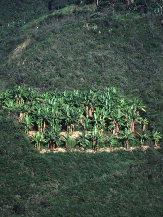
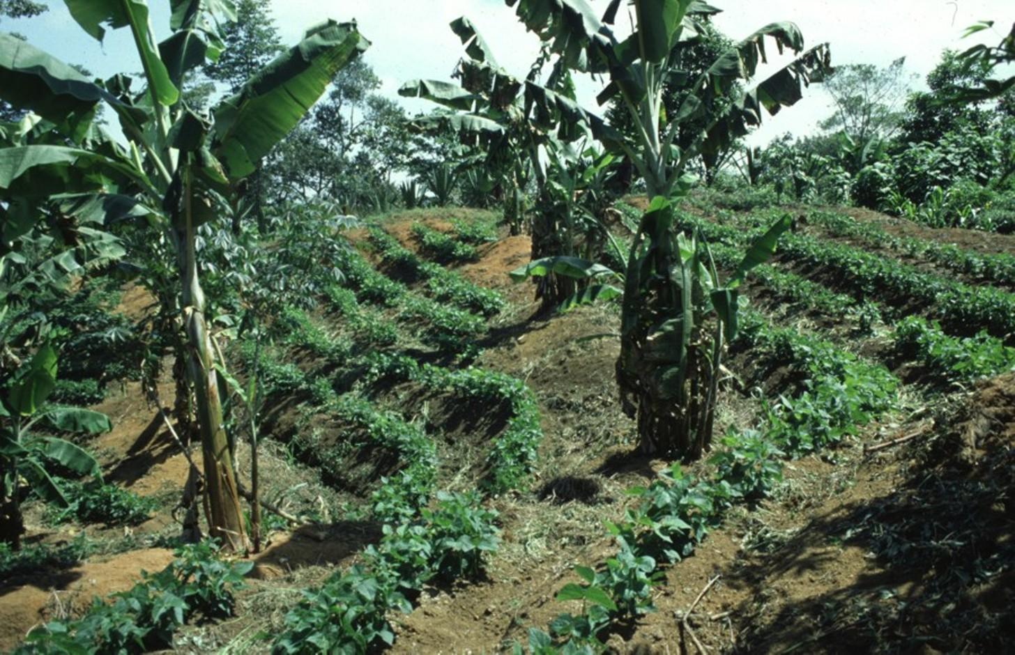
The intensive agroforestry system (silvoagricultura) combines traditional and newly developed practices adapted to the area’s conditions. The idea is to concentrate cropping on a limited area, a plot of 0.4 ha per household, in a highly integrated, intensive and diversified continuous land use system, thereby integrating soil and water conservation - specifically avoiding traditional slash and burn practices.
Each ‘agroforestry plot’ comprises four to five 50 cm wide and 40 m long multipurpose ditches that are excavated along the contour, 6 to 12 m apart, depending on the slope. The ditches retain runoff water which infiltrates the soil, thus reducing erosion and improving soil moisture. They also act as compost ditches for all types of organic residues on the farm. Residues, enriched with manure (from chickens and guinea pigs) are tipped into the ditches, and within 8 to12 months this decomposes into a fertile medium for the cultivation of vegetables and other crops.
The main purpose is to increase and diversify production, and at the same time to protect natural resources and regenerate degraded areas.
Grass strips are planted on the earth bund on the upper side of the ditch for stabilisation of the structure, retention of runoff and capture of eroded sediment. The grass is cut several times a year to feed guinea pigs, which in turn recycle this into manure. On the lower side of the contour ditches, fruit trees and bananas are planted. Rows of multipurpose trees (mainly indigenous species) are planted around each agroforestry plot as a windbreak and for economic reasons: yielding fruit and timber. Between the structures, annual (and semi-perennial) crops are grown on hand-dug micro-terraces/ridges, again sited along the contour. Some farmers intercrop with legumes. Supportive technologies are protection of wells,
afforestation and, where possible, irrigation to enhance production. Production is based on principles of organic farming.High initial inputs of external manure are subsidised by the project (CISEC; see associated approach). The remainder of each farmer’s land is left to natural regeneration, reforested, or where needed, used for conventional cropping
The system is implemented on degraded and often steep slopes in subhumid areas where intensive rainfall and dry periods alternate. The land is officially owned communally (an ‘Indigenous Reserve’), but land use rights are individual. The region has a high population density: people are basically of indigenous origin and live in very poor conditions.
2.3 Photos of the Technology
Media Gallery
2.5 Country/ region/ locations where the Technology has been applied and which are covered by this assessment
Country:
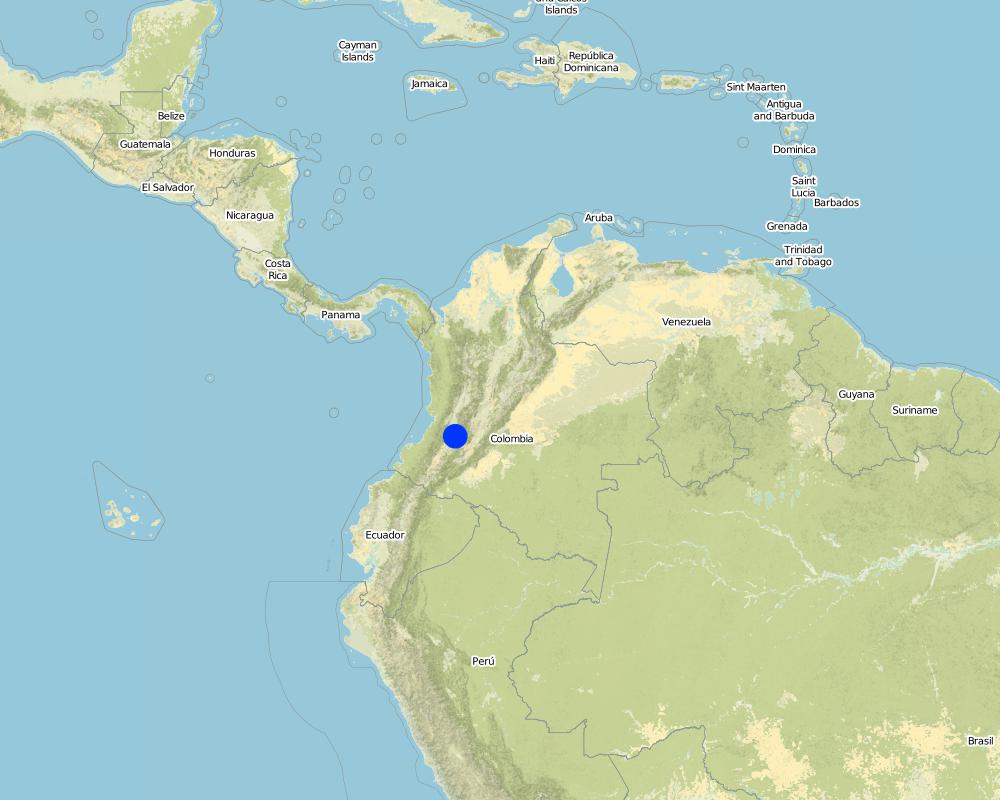
Colombia
Region/ State/ Province:
Cauca
Further specification of location:
Santander de Quilichao
Specify the spread of the Technology:
- evenly spread over an area
If the Technology is evenly spread over an area, specify area covered (in km2):
1.2
Comments:
Total area covered by the SLM Technology is 1.2 km2.
Map
×2.7 Introduction of the Technology
Specify how the Technology was introduced:
- through projects/ external interventions
3. Classification of the SLM Technology
3.1 Main purpose(s) of the Technology
- improve production
- reduce, prevent, restore land degradation
3.2 Current land use type(s) where the Technology is applied
Land use mixed within the same land unit:
Ja
Specify mixed land use (crops/ grazing/ trees):
- Agroforestry

Cropland
- Annual cropping
- Tree and shrub cropping
Specify:
Longest growing period in days: 240, Longest growing period from month to month: october untill may
Is intercropping practiced?
Ja
Comments:
Major land use problems (compiler’s opinion): - soil degradation/reduced soil fertility
- inappropriate soil management: monoculture, slash and burn, no or short fallow periods
- intensive rainfall on steep, unprotected slopes
- drought and wind erosion in dry season
- lack of economic resources
- high population density
3.4 Water supply
Water supply for the land on which the Technology is applied:
- rainfed
3.5 SLM group to which the Technology belongs
- agroforestry
- improved ground/ vegetation cover
- cross-slope measure
3.6 SLM measures comprising the Technology

agronomic measures
- A1: Vegetation/ soil cover

vegetative measures
- V1: Tree and shrub cover
- V2: Grasses and perennial herbaceous plants

structural measures
- S2: Bunds, banks
- S3: Graded ditches, channels, waterways
- S4: Level ditches, pits
Comments:
Type of agronomic measures: mixed cropping / intercropping, manure / compost / residues
3.7 Main types of land degradation addressed by the Technology

soil erosion by water
- Wt: loss of topsoil/ surface erosion

soil erosion by wind
- Et: loss of topsoil

chemical soil deterioration
- Cn: fertility decline and reduced organic matter content (not caused by erosion)
Comments:
Main causes of degradation: crop management (annual, perennial, tree/shrub) (inadequate management of land with steep slopes), overgrazing (prior degradation by landowner's livestock), industrial activities and mining (degradation of gold mining and other products), education, access to knowledge and support services, inter-generational subdivision of land (traditional custom)
Secondary causes of degradation: deforestation / removal of natural vegetation (incl. forest fires) (primary forest alomst disappeared), poverty / wealth (lack of capital, poverty and further agricultural employers)
3.8 Prevention, reduction, or restoration of land degradation
Specify the goal of the Technology with regard to land degradation:
- reduce land degradation
4. Technical specifications, implementation activities, inputs, and costs
4.1 Technical drawing of the Technology
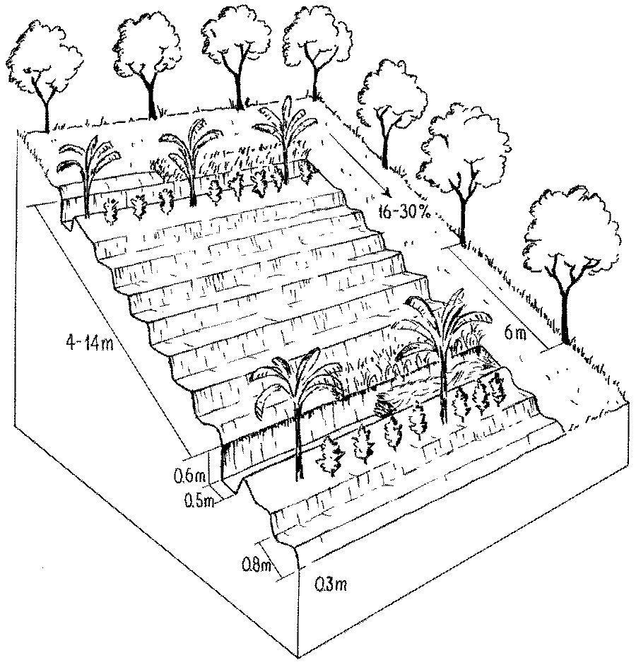
Technical specifications (related to technical drawing):
Detailed overview of the complex and intensive high-input, high output agroforestry system, usually limited to an area of 64 x 64 metres.
The agroforestry plots are bordered by trees of various species. Note the multipurpose ditches that serve as compost pits (lower ditch, right). Associated bunds are covered by grass (right).
Technical knowledge required for field staff / advisors: high
Technical knowledge required for land users: moderate
Main technical functions: control of raindrop splash, control of dispersed runoff: impede / retard, reduction of slope length, increase in organic matter, increase in nutrient availability (supply, recycling,…), increase / maintain water stored in soil
Secondary technical functions: reduction of slope angle, improvement of ground cover, increase of infiltration, sediment retention / trapping, sediment harvesting, reduction in wind speed
Vegetative measure: bananas
Vegetative material: F : fruit trees / shrubs
Vegetative measure: Vegetative material: F : fruit trees / shrubs
Slope (which determines the spacing indicated above): 16-30%
Author:
Mats Gurtner
4.3 Establishment activities
| Activity | Timing (season) | |
|---|---|---|
| 1. | 1. Clear land (only slashing, no burning). | Beginning of rainy season (April) |
| 2. | 2. Determine contours with A-frame, spacing between structures dependson slope (4 m between ditches on steepest slopes, 14 m on gentle slopes). | Beginning of rainy season (April) |
| 3. | 3. Dig ditches, build bunds above, and dig holes for tree seedlings. | Beginning of rainy season (April) |
| 4. | 4. Establish micro-terraces/ridges (earth enriched with manure and residues:all structures along the contour). | During the dry season (June to September) |
| 5. | 6. Plant grass strips on the bund (for stabilisation of structure). | During the dry season (June to September) |
| 6. | 7. Plant fruit/banana trees and legumes below the bunds. | During the dry season (June to September) |
| 7. | 8. Plant fruit and timber trees along the boundaries of the agroforestry | During the dry season (June to September) |
4.4 Costs and inputs needed for establishment
| Specify input | Unit | Quantity | Costs per Unit | Total costs per input | % of costs borne by land users | |
|---|---|---|---|---|---|---|
| Labour | labour | ha | 1.0 | 220.0 | 220.0 | 100.0 |
| Plant material | seeds | ha | 1.0 | 15.0 | 15.0 | 5.0 |
| Plant material | seedlings | ha | 1.0 | 450.0 | 450.0 | 5.0 |
| Fertilizers and biocides | compost/manure | ha | 1.0 | 600.0 | 600.0 | 5.0 |
| Total costs for establishment of the Technology | 1285.0 | |||||
| Total costs for establishment of the Technology in USD | 1285.0 | |||||
Comments:
Duration of establishment phase: 12 month(s)
4.5 Maintenance/ recurrent activities
| Activity | Timing/ frequency | |
|---|---|---|
| 1. | 5. Fill ditches with organic residues, adding earth mixed with manure. | During the dry season (June to September) / initial establishment |
| 2. | 4. Fill ditches with organic material, residues (after harvest), manure, etcand let it decompose. | |
| 3. | 6. Dig out compost and spread | (beginning of growing season (September) / |
| 4. | 7. Apply additional fertilizer/manure | / 3 times/year |
| 5. | 1. Cut grass ( grass used to feed guinea pigs). | /4–6 times/year |
| 6. | 2. Control weeds | /3 times/year |
| 7. | 5. Plant vegetables on fertile composted earth in ditches | /dry season, optional |
| 8. | 8. Plant various crops: contour cropping, intercropping, integrate greenmanures (legumes). | |
| 9. | 3. Rebuild/repair structures | dry season |
4.6 Costs and inputs needed for maintenance/ recurrent activities (per year)
| Specify input | Unit | Quantity | Costs per Unit | Total costs per input | % of costs borne by land users | |
|---|---|---|---|---|---|---|
| Labour | labour | ha | 1.0 | 100.0 | 100.0 | 100.0 |
| Fertilizers and biocides | biocides | ha | 1.0 | 45.0 | 45.0 | 100.0 |
| Total costs for maintenance of the Technology | 145.0 | |||||
| Total costs for maintenance of the Technology in USD | 145.0 | |||||
Comments:
Machinery/ tools: machete, shovel, pickaxes, A-frame, planting stick (chuzo)
As an exception in this case study costs are calculated per plot and not per ha, since establishment is strictly limited
to an area of 0.4 ha per household. The remaining area is not treated but left for natural regeneration of vegetation or
conventional farming (if needed). Labour costs vary according to slope: a typical/average situation is given in the tables above (no further details available). Note that for comparison purposes with other technologies on a per hectare basis these costs would equate to US$ 3,135 for establishment and US$ 355 for maintenance.
5. Natural and human environment
5.1 Climate
Annual rainfall
- < 250 mm
- 251-500 mm
- 501-750 mm
- 751-1,000 mm
- 1,001-1,500 mm
- 1,501-2,000 mm
- 2,001-3,000 mm
- 3,001-4,000 mm
- > 4,000 mm
Agro-climatic zone
- sub-humid
Thermal climate class: tropics
5.2 Topography
Slopes on average:
- flat (0-2%)
- gentle (3-5%)
- moderate (6-10%)
- rolling (11-15%)
- hilly (16-30%)
- steep (31-60%)
- very steep (>60%)
Landforms:
- plateau/plains
- ridges
- mountain slopes
- hill slopes
- footslopes
- valley floors
Altitudinal zone:
- 0-100 m a.s.l.
- 101-500 m a.s.l.
- 501-1,000 m a.s.l.
- 1,001-1,500 m a.s.l.
- 1,501-2,000 m a.s.l.
- 2,001-2,500 m a.s.l.
- 2,501-3,000 m a.s.l.
- 3,001-4,000 m a.s.l.
- > 4,000 m a.s.l.
5.3 Soils
Soil depth on average:
- very shallow (0-20 cm)
- shallow (21-50 cm)
- moderately deep (51-80 cm)
- deep (81-120 cm)
- very deep (> 120 cm)
Soil texture (topsoil):
- coarse/ light (sandy)
- medium (loamy, silty)
Topsoil organic matter:
- high (>3%)
- medium (1-3%)
5.6 Characteristics of land users applying the Technology
Market orientation of production system:
- subsistence (self-supply)
- mixed (subsistence/ commercial)
Off-farm income:
- less than 10% of all income
Level of mechanization:
- manual work
Indicate other relevant characteristics of the land users:
Off-farm income specification: most farmers depend economically entirely on their own crop production
5.7 Average area of land used by land users applying the Technology
- < 0.5 ha
- 0.5-1 ha
- 1-2 ha
- 2-5 ha
- 5-15 ha
- 15-50 ha
- 50-100 ha
- 100-500 ha
- 500-1,000 ha
- 1,000-10,000 ha
- > 10,000 ha
5.8 Land ownership, land use rights, and water use rights
Land ownership:
- communal/ village
- individual, not titled
Land use rights:
- communal (organized)
- individual
6. Impacts and concluding statements
6.1 On-site impacts the Technology has shown
Socio-economic impacts
Production
crop production
fodder production
fodder quality
wood production
Income and costs
farm income
economic disparities
workload
Socio-cultural impacts
community institutions
conflict mitigation
Comments/ specify:
friction between participants and non-participants
Ecological impacts
Soil
soil moisture
soil cover
soil loss
acidity
Comments/ specify:
high content of organic matter
Biodiversity: vegetation, animals
pest/ disease control
Climate and disaster risk reduction
wind velocity
6.2 Off-site impacts the Technology has shown
reliable and stable stream flows in dry season
Comments/ specify:
use of water for irrigation
downstream siltation
groundwater/ river pollution
wind transported sediments
6.4 Cost-benefit analysis
How do the benefits compare with the establishment costs (from land users’ perspective)?
Short-term returns:
positive
Long-term returns:
very positive
How do the benefits compare with the maintenance/ recurrent costs (from land users' perspective)?
Short-term returns:
positive
Long-term returns:
very positive
6.5 Adoption of the Technology
Comments:
100% of land user families have adopted the Technology with external material support
260 land user families have adopted the Technology with external material support
There is a little trend towards spontaneous adoption of the Technology. There is a slight growing spontaneous adoption by land users living outside the approach area.
6.7 Strengths/ advantages/ opportunities of the Technology
| Strengths/ advantages/ opportunities in the compiler’s or other key resource person’s view |
|---|
| Rehabilitation of soil fertility over short term |
| Increased and permanent production |
| Increased food security and balanced diet |
| Adapted to very heterogeneous climatic and topographic conditions. |
| Protective-productive system: compromise between land capability class (forest) and cultivation needs |
6.8 Weaknesses/ disadvantages/ risks of the Technology and ways of overcoming them
| Weaknesses/ disadvantages/ risks in the compiler’s or other key resource person’s view | How can they be overcome? |
|---|---|
| Rigid design of the technology and fixed guidelines for implementation activities (pre-conditions for incentive support by project) | Give more flexibility to the farmers for individual modifications. |
| High demand for manual labour |
Emphasis on group work, implement in dry season (when labour force is available at the household level). |
| High external inputs at the beginning (makes the technology very expensive) |
Manure is needed to restore soil fertility in the short-term, land users pay the inputs in form of labour in the CISEC; revolving funds and composting ensure manure supplies on the long term. |
| Decreased pH (soil acidity) |
Compensate by ecological improvements such as application of lime and ashes. |
7. References and links
7.1 Methods/ sources of information
- field visits, field surveys
- interviews with land users
When were the data compiled (in the field)?
01/07/2004
7.2 References to available publications
Title, author, year, ISBN:
CISEC . Establecimiento de Lotes de Silvoagricultura. 1998.
Title, author, year, ISBN:
Gurtner M . Bodendegradierung und Bodenkonservierung inden Anden Kolumbiens – Eine Nachhaltigkeitsstudie im Rahmen des WOCAT-Programms, unpublished MSc Thesis, Science Faculty, University of Berne,Centre for Development and Environment. 1999.
Links and modules
Expand all Collapse allLinks
Desarrollo Rural Integral Comunitario [Colombia]
En un proceso participativo y comunitario y a través de la capacitación, la asistencia técnica y la suministración de insumos importantes se fomenta el establecimiento de un sistema agrosilicultural en la comunidad indÃgena.
- Compiler: Mathias Gurtner
Modules
No modules