Dawa-Cheffa Traditional Checkdam [Ethiopia]
- Creation:
- Update:
- Compiler: Unknown User
- Editor: –
- Reviewers: Fabian Ottiger, Alexandra Gavilano
Kiter
technologies_1058 - Ethiopia
View sections
Expand all Collapse all1. General information
1.2 Contact details of resource persons and institutions involved in the assessment and documentation of the Technology
Key resource person(s)
SLM specialist:
Umer Kemal
Dewa Chefe Woreda Agriculture and Rural Development Office (DWARAO)
Ethiopia
Name of the institution(s) which facilitated the documentation/ evaluation of the Technology (if relevant)
Ministry of Agriculture and Rural Development (Ministry of Agriculture and Rural Development) - Ethiopia1.3 Conditions regarding the use of data documented through WOCAT
The compiler and key resource person(s) accept the conditions regarding the use of data documented through WOCAT:
Ja
2. Description of the SLM Technology
2.1 Short description of the Technology
Definition of the Technology:
A structural measure constructed by stone/soil/wood acrross the gully to control erosion and create favourble condition for crop cultivation.
2.2 Detailed description of the Technology
Description:
The technology is known by the farmers for more than a century. Since the area is highly affected by gully erosion, this practice is widely used by farmers in the area and also widely practiced. Its construction starts from the bottom of the gully and proceeds upslope with different dimensions. The height depends on the depth of the gully and it is increased from year to year. On the average the width is 1m and hieght is 1.80m. The technology is used to develop big gullies and treatment of small gully like depressions, attain slope change to enhance land suitability to crop production and to conserve soil and water. The construction of the stone checkdam starts with small heights and some height is added every year until the intended height is reached. The increase in height could be done during maintenance also. The major objective being to stop gully growth, trap sediment and retain water running down the gully. In the course of increasing the height, the area for sediment deposition gets wider. The technology is suitable to areas with low rainfalls of rugged topography having a network of gullies.
2.5 Country/ region/ locations where the Technology has been applied and which are covered by this assessment
Country:
Ethiopia
Region/ State/ Province:
Amhara Regional State
Further specification of location:
Koshem Watershed
Specify the spread of the Technology:
- evenly spread over an area
If precise area is not known, indicate approximate area covered:
- 10-100 km2
Comments:
Total area covered by the SLM Technology is 810 km2.
The technology is mostly practiced in the eastern escarpment of the the woreda experiencing low and erratic rains. Area is estimated
Map
×2.6 Date of implementation
If precise year is not known, indicate approximate date:
- more than 50 years ago (traditional)
2.7 Introduction of the Technology
Specify how the Technology was introduced:
- as part of a traditional system (> 50 years)
Comments (type of project, etc.):
Is developed by land users themselves
3. Classification of the SLM Technology
3.1 Main purpose(s) of the Technology
- improve production
- reduce, prevent, restore land degradation
3.2 Current land use type(s) where the Technology is applied

Cropland
- Annual cropping
- Perennial (non-woody) cropping
- Tree and shrub cropping
Annual cropping - Specify crops:
- cereals - maize
- cereals - sorghum
- legumes and pulses - beans
- legumes and pulses - other
- oilseed crops - sunflower, rapeseed, other
- haricot bean, teff
- sugar cane, elephant grass, local grass
Tree and shrub cropping - Specify crops:
- citrus
- coffee, open grown
- fruits, other
- mango, mangosteen, guava
- papaya
- acacia, eucalyptus, khata edulis, ageava sisal, banana, lemon
Number of growing seasons per year:
- 2
Specify:
Longest growing period in days: 210 Longest growing period from month to month: May - Nov Second longest growing period in days: 180 Second longest growing period from month to month: Jan - Apr
Is intercropping practiced?
Ja
If yes, specify which crops are intercropped:
sorghum/maize +haricot beans

Grazing land

Forest/ woodlands
- (Semi-)natural forests/ woodlands
(Semi-)natural forests/ woodlands: Specify management type:
- Clear felling
Products and services:
- Timber
- Fuelwood
- Grazing/ browsing
Comments:
Major land use problems (compiler’s opinion): Increase in human and animal population, overggrazing and expansion of cultivated lands to areas which are not suitable to cultivation is a problem. Meanwhile, owing to gully expansion and in the absence of preventive and control measures, there is considerable loss of soil from grazing and cultivated lands.
Major land use problems (land users’ perception): More area is getting out of production.
Other grazingland: extensive: pastoralism: in the eastern side of the SWC technology area
Other grazingland: extensive: semi-pastoralism: on the ridgea nd hilly slopes where land users are engaged in crop and livestock production
Grazingland comments: Livestock production is decreasing primarily because of decreasing grazing lands. The number of livestock being the most important factor for herd owners than the quailty. More extension work will be needed to promot the awarness of livestock owners in a way they give emphases to quality of livestock production than numbers.
Clear felling of (semi-)natural forests: to open land for cultivation, chrcoal making
Problems / comments regarding forest use: The natural forest/wood lands are decreasing mainly to expansion of cultivation and also due to high demand for use. However, because of plantations on gullies, hillside closures and woodlots there is a positive trend of increase of planted trees.
Type of cropping system and major crops comments: Fruit trees, sugar cane, pulses
Type of grazing system comments: Livestock production is decreasing primarily because of decreasing grazing lands. The number of livestock being the most important factor for herd owners than the quailty. More extension work will be needed to promot the awarness of livestock owners in a way they give emphases to quality of livestock production than numbers.
3.4 Water supply
Water supply for the land on which the Technology is applied:
- rainfed
Comments:
Water supply: Also mixed rainfed - irrigated
Water supply: post-flooding
3.5 SLM group to which the Technology belongs
- surface water management (spring, river, lakes, sea)
3.6 SLM measures comprising the Technology

agronomic measures
- A1: Vegetation/ soil cover
- A2: Organic matter/ soil fertility
- A3: Soil surface treatment
- A6: Residue management
- A7: Others

vegetative measures

structural measures
- S6: Walls, barriers, palisades, fences
Comments:
Main measures: structural measures
Secondary measures: agronomic measures, vegetative measures
Type of agronomic measures: mixed cropping / intercropping, contour planting / strip cropping, legume inter-planting, manure / compost / residues, contour tillage
Type of vegetative measures: aligned: -contour
3.7 Main types of land degradation addressed by the Technology

soil erosion by water
- Wt: loss of topsoil/ surface erosion
- Wg: gully erosion/ gullying

chemical soil deterioration
- Cn: fertility decline and reduced organic matter content (not caused by erosion)
Comments:
Main type of degradation addressed: Wg: gully erosion / gullying
Secondary types of degradation addressed: Wt: loss of topsoil / surface erosion, Cn: fertility decline and reduced organic matter content
Main causes of degradation: deforestation / removal of natural vegetation (incl. forest fires), overgrazing, other human induced causes (specify) (agricultural causes), labour availability (lack of labour), land subdivision
Secondary causes of degradation: over-exploitation of vegetation for domestic use, other natural causes (avalanches, volcanic eruptions, mud flows, highly susceptible natural resources, extreme topography, etc.) specify, poverty / wealth (lack of captial), education, access to knowledge and support services (lack of knowledge), lack of enforcement of legislat./authority
3.8 Prevention, reduction, or restoration of land degradation
Specify the goal of the Technology with regard to land degradation:
- restore/ rehabilitate severely degraded land
Comments:
Secondary goals: prevention of land degradation, mitigation / reduction of land degradation
4. Technical specifications, implementation activities, inputs, and costs
4.1 Technical drawing of the Technology
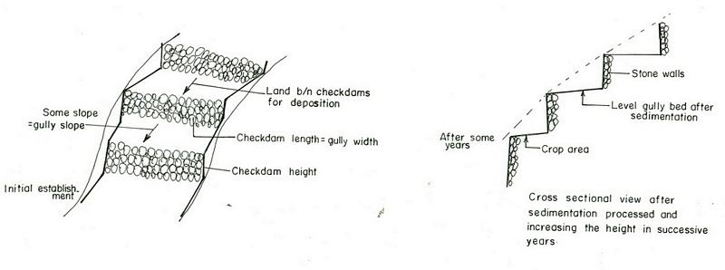
Technical specifications (related to technical drawing):
Amhara
Technical knowledge required for field staff / advisors: high
Technical knowledge required for land users: moderate
Main technical functions: increase / maintain water stored in soil, sediment retention / trapping, sediment harvesting
Secondary technical functions: reduction of slope angle, reduction of slope length, increase of infiltration
Mixed cropping / intercropping
Material/ species: sorghum/maize +haricot beans
Quantity/ density: 70,000 sor
Remarks: broadcast
Agronomic measure: mixed cropping / intercropping
Material/ species: teff + sunflower
Quantity/ density: -
Remarks: broadcast
Manure / compost / residues
Material/ species: Animal dung, fuelwood ash, leaves, soil
Quantity/ density: 0.6 ton/ha
Contour tillage
Remarks: along contour
Agronomic measure: Sediment trapped by checkdam
Remarks: along the contour
Agronomic measure: Seedbed preparation by hoe
Aligned: -contour
Vegetative material: T : trees / shrubs
Number of plants per (ha): 1500
Vertical interval between rows / strips / blocks (m): 1-1.8m
Spacing between rows / strips / blocks (m): 8-10m
Vertical interval within rows / strips / blocks (m): 1-2m
Width within rows / strips / blocks (m): 1x1
Vegetative measure: aligned: contour
Vegetative material: G : grass
Number of plants per (ha): -
Vertical interval between rows / strips / blocks (m): 1-1.8m
Spacing between rows / strips / blocks (m): 8-10m
Vertical interval within rows / strips / blocks (m): -
Width within rows / strips / blocks (m): -
Vegetative measure: aligned: contour
Vegetative material: G : grass
Number of plants per (ha): 2000
Vertical interval between rows / strips / blocks (m): 1-1.8m
Spacing between rows / strips / blocks (m): 8-10m
Vertical interval within rows / strips / blocks (m): -
Width within rows / strips / blocks (m): -
Vegetative measure: Vegetative material: G : grass
Vegetative measure: Vegetative material: G : grass
Trees/ shrubs species: acacia, eucalyptus, khata edulis, ageava sisal
Fruit trees / shrubs species: coffee, papaya, guava, banana, lemon, manago, orange
Grass species: elephant grass, local grass
Slope (which determines the spacing indicated above): 12.00%
If the original slope has changed as a result of the Technology, the slope today is (see figure below): 3.00%
Gradient along the rows / strips: 0.00%
Structural measure: Checkdam
Vertical interval between structures (m): 1
Spacing between structures (m): 8m
Depth of ditches/pits/dams (m): 0.3m
Width of ditches/pits/dams (m): 1m
Length of ditches/pits/dams (m): 5m
Height of bunds/banks/others (m): 0.5-1m
Width of bunds/banks/others (m): 1m
Length of bunds/banks/others (m): 5.m
Construction material (earth): Soil is embnked upslope of the stone wall as reinforcement
Construction material (stone): Stone is used to construct the embankment/wall/and is supported by soil in the upslope side to reinf
Construction material (wood): Wood used as support at the downslope side
Slope (which determines the spacing indicated above): 12%
If the original slope has changed as a result of the Technology, the slope today is: 3%
Lateral gradient along the structure: 0%
For water harvesting: the ratio between the area where the harvested water is applied and the total area from which water is collected is: 1:3
Vegetation is used for stabilisation of structures.
Change of land use type: gully converted to cropland
Other type of management: fencing and guarding - protect animals from interering to plantations
4.2 General information regarding the calculation of inputs and costs
other/ national currency (specify):
Birr
If relevant, indicate exchange rate from USD to local currency (e.g. 1 USD = 79.9 Brazilian Real): 1 USD =:
8.6
Indicate average wage cost of hired labour per day:
0.70
4.3 Establishment activities
| Activity | Timing (season) | |
|---|---|---|
| 1. | Seedling production | March to June |
| 2. | Planting | June to July |
| 3. | Excavation | dry season |
| 4. | Stone collection | dry season |
| 5. | Construction | dry season |
| 6. | Fencing | after plantation |
4.4 Costs and inputs needed for establishment
| Specify input | Unit | Quantity | Costs per Unit | Total costs per input | % of costs borne by land users | |
|---|---|---|---|---|---|---|
| Labour | Labour | ha | 1.0 | 4625.0 | 4625.0 | 90.0 |
| Equipment | Tools | ha | 1.0 | 120.0 | 120.0 | 95.0 |
| Construction material | Stone | ha | 1.0 | 100.0 | ||
| Total costs for establishment of the Technology | 4745.0 | |||||
| Total costs for establishment of the Technology in USD | 551.74 | |||||
Comments:
Duration of establishment phase: 180 month(s)
4.5 Maintenance/ recurrent activities
| Activity | Timing/ frequency | |
|---|---|---|
| 1. | clean crop residue | Early January / |
| 2. | primary digging | Feb-March / |
| 3. | harrowing | March / |
| 4. | manure application | March / |
| 5. | planting | April / |
| 6. | weeding and cultivation | Late June-August / |
| 7. | harvest | November-December / |
| 8. | replanting | during rains /once a year |
| 9. | pruning and thining | dry season /once a year |
| 10. | Stone collection | dry season/once a year |
| 11. | Placing the stones where maintenance is required | dry season/once a year |
| 12. | repairing breaks in fences | before replanting / annual |
4.6 Costs and inputs needed for maintenance/ recurrent activities (per year)
| Specify input | Unit | Quantity | Costs per Unit | Total costs per input | % of costs borne by land users | |
|---|---|---|---|---|---|---|
| Labour | Labour | ha | 1.0 | 624.0 | 624.0 | 100.0 |
| Equipment | Tools | ha | 1.0 | 30.0 | 30.0 | 100.0 |
| Construction material | Stone | ha | 1.0 | 100.0 | ||
| Total costs for maintenance of the Technology | 654.0 | |||||
| Total costs for maintenance of the Technology in USD | 76.05 | |||||
Comments:
Machinery/ tools: Shovel, hoe
Length per hectar of land
4.7 Most important factors affecting the costs
Describe the most determinate factors affecting the costs:
labour, slope and depth of the gully, width of the gully, availability of construction material, soil depth. The establishment cost considerts the cost incurred over 15 years.
5. Natural and human environment
5.1 Climate
Annual rainfall
- < 250 mm
- 251-500 mm
- 501-750 mm
- 751-1,000 mm
- 1,001-1,500 mm
- 1,501-2,000 mm
- 2,001-3,000 mm
- 3,001-4,000 mm
- > 4,000 mm
Specifications/ comments on rainfall:
Specification 500-750 mm (600mm)
Specification 750-1000 mm (900mm)
Agro-climatic zone
- sub-humid
- semi-arid
Semi-arid: In the SWC area the semiarid part is about 70%
Sub-humid: Comprises about 30%
5.2 Topography
Slopes on average:
- flat (0-2%)
- gentle (3-5%)
- moderate (6-10%)
- rolling (11-15%)
- hilly (16-30%)
- steep (31-60%)
- very steep (>60%)
Landforms:
- plateau/plains
- ridges
- mountain slopes
- hill slopes
- footslopes
- valley floors
Altitudinal zone:
- 0-100 m a.s.l.
- 101-500 m a.s.l.
- 501-1,000 m a.s.l.
- 1,001-1,500 m a.s.l.
- 1,501-2,000 m a.s.l.
- 2,001-2,500 m a.s.l.
- 2,501-3,000 m a.s.l.
- 3,001-4,000 m a.s.l.
- > 4,000 m a.s.l.
Comments and further specifications on topography:
Landforms: Hill slopes (ranked 1, relatively drier and the technology is most suitable to this area) and ridges (ranked 2, the ridge separates the east and west parts the SWC area)
Slopes on average: Hilly (ranked 1, mostly terraced of stone bunds), rolling (ranked 2, more number of gullies and more area under the technology) and steep (ranked 3, bush lands suitable for grazing)
5.3 Soils
Soil depth on average:
- very shallow (0-20 cm)
- shallow (21-50 cm)
- moderately deep (51-80 cm)
- deep (81-120 cm)
- very deep (> 120 cm)
Soil texture (topsoil):
- coarse/ light (sandy)
- medium (loamy, silty)
Topsoil organic matter:
- low (<1%)
If available, attach full soil description or specify the available information, e.g. soil type, soil PH/ acidity, Cation Exchange Capacity, nitrogen, salinity etc.
Soil depth on average: Shallow (ranked1, more on hill slopes), moderately deep (ranked 2, on rolling terrain) and very shallow (ranked 3, on hilly and steep slopes)
Soil texture: Medium (dominant on hilly slopes) and coarse/light (on rolling terrains)
Soil fertility is low (on hilly sloping areas) and medium (on rolling lands)
Topsoil organic matter: Low (in all land forms)
Soil drainage/infiltration is good (on hilly and rolling lands) and medium (ridge)
Soil water storage capacity is low (on hilly and rolling lands) and medium (ridge)
5.6 Characteristics of land users applying the Technology
Market orientation of production system:
- subsistence (self-supply)
- mixed (subsistence/ commercial)
Off-farm income:
- less than 10% of all income
Relative level of wealth:
- poor
- average
Level of mechanization:
- manual work
- animal traction
Indicate other relevant characteristics of the land users:
Population density: 50-100 persons/km2
Annual population growth: 2% - 3%
20% of the land users are rich and own 30% of the land.
35% of the land users are average wealthy and own 30% of the land.
45% of the land users are poor and own 40% of the land.
Market orientation of garzing land production system: Subsistence (self-supply, production ids for self consumption and even it does not satistfy household needs)
Market orientation of crop land production system: Subsistence (self-supply) and mixed (subsistence and commercial)
Market orientation of crop land production system: Subsistence (self-supply, fuel wood collection for home consumption , construction wood, sell fuel woo and , make charcoal )
5.7 Average area of land used by land users applying the Technology
- < 0.5 ha
- 0.5-1 ha
- 1-2 ha
- 2-5 ha
- 5-15 ha
- 15-50 ha
- 50-100 ha
- 100-500 ha
- 500-1,000 ha
- 1,000-10,000 ha
- > 10,000 ha
5.8 Land ownership, land use rights, and water use rights
Land ownership:
- state
Land use rights:
- individual
6. Impacts and concluding statements
6.1 On-site impacts the Technology has shown
Socio-economic impacts
Production
crop production
Comments/ specify:
The cost benefit anlysis for sorghum shows negative profit but for other crops such as combination of coffe, papaya, chat the profit is high
fodder production
fodder quality
Income and costs
farm income
Comments/ specify:
for cropping patterns which consider field crops + cash crops is high
Socio-cultural impacts
SLM/ land degradation knowledge
Ecological impacts
Water cycle/ runoff
surface runoff
Quantity before SLM:
70
Quantity after SLM:
5
Soil
soil moisture
Comments/ specify:
soil depth increased by depostion infiltration enhanced
soil cover
Comments/ specify:
plantations
soil loss
Quantity before SLM:
10
Quantity after SLM:
0
Comments/ specify:
checdams decrease gully slope
Other ecological impacts
Soil fertility
Comments/ specify:
Fertile top soil erdoed upslope is trapped in the gully
Biodiversity
Comments/ specify:
combined application of useful plants and crop
6.2 Off-site impacts the Technology has shown
reliable and stable stream flows in dry season
Comments/ specify:
high percolation rate of rain water
downstream flooding
Comments/ specify:
runoff is trapped by supportive technologies undertaken in the upper catchment and runoof velocity retarded by checkdams
downstream siltation
Comments/ specify:
sediment trapped in the gullies
6.4 Cost-benefit analysis
How do the benefits compare with the establishment costs (from land users’ perspective)?
Short-term returns:
negative
Long-term returns:
positive
How do the benefits compare with the maintenance/ recurrent costs (from land users' perspective)?
Short-term returns:
slightly negative
Long-term returns:
positive
6.5 Adoption of the Technology
If available, quantify (no. of households and/ or area covered):
25000
Of all those who have adopted the Technology, how many did so spontaneously, i.e. without receiving any material incentives/ payments?
- 91-100%
Comments:
25000 land user families have adopted the Technology with external material support
Comments on acceptance with external material support: estimates
100% of land user families have adopted the Technology without any external material support
25000 land user families have adopted the Technology without any external material support
Comments on spontaneous adoption: estimates
There is a little trend towards spontaneous adoption of the Technology
Comments on adoption trend: Reclaiming gullies for agricultural land (crop and livestock production) is labourous.
6.7 Strengths/ advantages/ opportunities of the Technology
| Strengths/ advantages/ opportunities in the land user’s view |
|---|
|
Land reclaimed How can they be sustained / enhanced? fertility of soils increased by accumulated top soil from other area. |
|
retain moisture How can they be sustained / enhanced? water stored in the soil. |
| Strengths/ advantages/ opportunities in the compiler’s or other key resource person’s view |
|---|
|
Reduce runoff speed How can they be sustained / enhanced? exercise frequent maintenance and stablize the structure with vegetative measures |
|
Reduce soil loss How can they be sustained / enhanced? soil is trapped by the checkdam |
|
Moisture retention How can they be sustained / enhanced? the soil trapped provides more space for water to be stored. |
|
reduce slope length How can they be sustained / enhanced? by raising the gully bed. |
7. References and links
7.1 Methods/ sources of information
7.2 References to available publications
Title, author, year, ISBN:
Monthly, quarterly and annual achievement reports of the DWARDO
Title, author, year, ISBN:
Work norm of MERET
Title, author, year, ISBN:
Ethiopian Highlands Reclamation stdy
Title, author, year, ISBN:
Soil and water conservation , Morgan 1986
Links and modules
Expand all Collapse allLinks
No links
Modules
No modules