Zai or tassa planting pits [Niger]
- Creation:
- Update:
- Compiler: Dieter Nill
- Editor: –
- Reviewers: Alexandra Gavilano, Deborah Niggli, Nina Lauterburg, Fabian Ottiger
Zaï - Tassa (French)
technologies_1219 - Niger
View sections
Expand all Collapse all1. General information
1.2 Contact details of resource persons and institutions involved in the assessment and documentation of the Technology
SLM specialist:
Dorlöchter-Sulser Sabine
Misereor
Germany
SLM specialist:
Mamadou Abdou Sani
Programme d’Appui à l’agriculture Productive (PROMAP)/GIZ
Niger
Name of project which facilitated the documentation/ evaluation of the Technology (if relevant)
Manual of Good Practices in Small Scale Irrigation in the Sahel (GIZ )Name of the institution(s) which facilitated the documentation/ evaluation of the Technology (if relevant)
Deutsche Gesellschaft für Internationale Zusammenarbeit (GIZ) - GermanyName of the institution(s) which facilitated the documentation/ evaluation of the Technology (if relevant)
Misereor - Germany1.3 Conditions regarding the use of data documented through WOCAT
The compiler and key resource person(s) accept the conditions regarding the use of data documented through WOCAT:
Ja
1.4 Declaration on sustainability of the described Technology
Is the Technology described here problematic with regard to land degradation, so that it cannot be declared a sustainable land management technology?
Nee
2. Description of the SLM Technology
2.1 Short description of the Technology
Definition of the Technology:
Zai planting pits are designed to collect rainwater and to conserve nutrients in order to improve crop production and food security.
2.2 Detailed description of the Technology
Description:
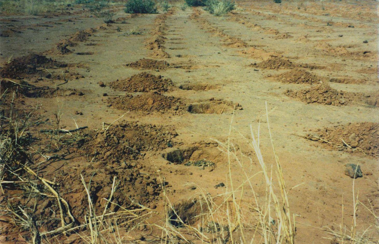
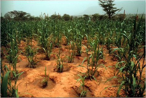
Zai or tassa planting pits are an old farming technique rediscovered after the great drought of 1973/74 and later perfected by development partners working with the farmers. It involves digging planting pits with a diameter of at least 30 to 40 cm and 10 to 15 cm deep. They are spaced 70 to 80 cm apart, resulting in around 10,000 pits per hectare. Staggered rows of holes are dug perpendicularly to the slope. The earth dug out of the hole is piled up to form a small ridge around the rim, which captures water. A couple of handfuls of organic fertiliser or compost are put into each pit. They are normally made in the dry season before the first rains start. However, it is recommended that the pits be made immediately after the rainy season, when the soil is still moist and the weather is not too hot. If the pits are in place early in the dry season, they act as traps during the windy period in February and March, retaining rich dust carried by the harmattan and wind-blown organic matter. At least 3 tonnes of compost per hectare is recommended.
Purpose of the Technology: The arrangement of the pits in staggered rows ensures the most efficient collection of rainwater and slows the flow of water over the surface. The zai technique concentrates and conserves nutrients and water near the roots of the plants grown in them. The application of organic fertiliser directly around the plants is an economical use of a factor of production to which most farmers have limited access. It also reactivates biological activity, increases fertility and loosens the soil.
As zai planting pits restore degraded, uncultivated land, they lessen the pressure to clear other land for farming. They also reduce the vulnerability of plants during dry spells and droughts, ensuring crop production and improving food security.
Plots with zai planting pits (with fertiliser) average yields of 409 kg of millet grain per hectare, compared to 195 kg per hectare registered on control plots. Millet yields can therefore be doubled with this technique.
Establishment / maintenance activities and inputs: The zai technique requires high labour input. It is estimated that between 40 and 60 man-days per hectare are required, depending on the density of the pits. There is a mechanised system for making the holes, using a special animal-drawn plough, which considerably reduces the number of man-days required to 7 per hectare.
If the pits are prepared each year or once every two years (using the same pits or making new ones in the spaces between the old ones), soil fertility is restored and the crop cycle can be resumed. The application of organic fertiliser in sufficient quantities enables the plot to be cultivated sustainably. After five years, it can be farmed in the normal way.
Covering extensive areas with zai planting pits requires a high level of community mobilisation and effective organisation and logistics. Apart from this, the technique is very simple to implement and easily mastered by the farmers.
Natural / human environment: Zai planting pits are used on marginal or degraded land that is no longer cultivated, such as low-gradient pediments and land with encrusted soil in areas with rainfall levels of less than 800 mm a year. They are not recommended for sandy soils, as they are not stable when dug in this type of soil, or for valley bottoms, where they risk being flooded. Zai planting pits are particularly useful in areas where land use pressure is high, as they permit the rehabilitation of unproductive land for farming.
From the point of view of climate change adaptation, zai planting pits are particularly useful in areas with erratic or low rainfall, as they prevent the loss of water. As the fertiliser is placed inside the pits, it is not washed away by heavy rain.
2.3 Photos of the Technology
Media Gallery
2.5 Country/ region/ locations where the Technology has been applied and which are covered by this assessment
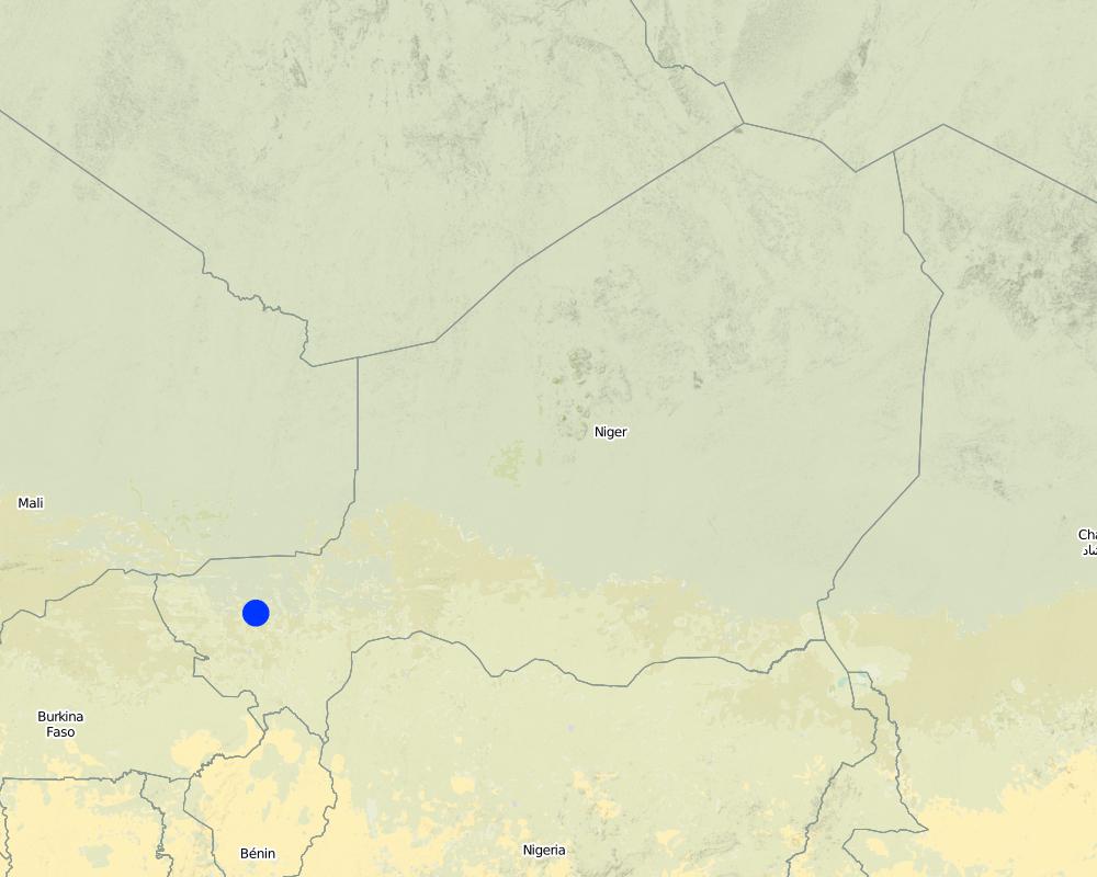
Country:
Niger
Region/ State/ Province:
Niger
Further specification of location:
Regions of Tillabéri, Filingué, Ouallam, Téra and Tahuoa
Map
×2.6 Date of implementation
If precise year is not known, indicate approximate date:
- 10-50 years ago
2.7 Introduction of the Technology
Specify how the Technology was introduced:
- through projects/ external interventions
Comments (type of project, etc.):
developed, implemented and disseminated as part of projects and programmes undertaken from the 1980s onwards to combat desertification and improve natural resource management. Implemented by GIZ (German Federal Enterprise for International Cooperation), PDRT (Projet de développement rural de Tahoua - Tahoua Rural Development Project), PASP (Projet de protection intégrée des ressources agro-sylvo-pastorales Tillabéri-Nord - Project for the Integrated Protection of Agricultural, Forest and Rangeland Resources in Tillabéri-Nord)
3. Classification of the SLM Technology
3.1 Main purpose(s) of the Technology
- improve production
- create beneficial economic impact
3.2 Current land use type(s) where the Technology is applied
Land use mixed within the same land unit:
Ja
Specify mixed land use (crops/ grazing/ trees):
- Agro-silvopastoralism

Cropland
- Annual cropping
- Tree and shrub cropping
Annual cropping - Specify crops:
- oilseed crops - groundnuts
- cereals - millet
- cereals - sorghum
- legumes and pulses - peas
Tree and shrub cropping - Specify crops:
- mango, mangosteen, guava
Number of growing seasons per year:
- 1
Specify:
Longest growing period in days: 120, Longest growing period from month to month: August to October

Grazing land
Extensive grazing:
- Nomadism
- Semi-nomadic pastoralism
Intensive grazing/ fodder production:
- Cut-and-carry/ zero grazing
- Improved pastures

Forest/ woodlands
- (Semi-)natural forests/ woodlands
(Semi-)natural forests/ woodlands: Specify management type:
- Selective felling
- Clear felling
Products and services:
- Timber
- Fuelwood
- Fruits and nuts
- Other forest products
- Grazing/ browsing
Comments:
Major cash crop: Ground nut
Major food crop: Millet
Major other crops: Sorghum, cow pea and mangos
Major land use problems (compiler’s opinion): soil erosion, fertility decline, aridification, loss of limited rainwater by runoff
Type of cropping system and major crops comments: farmers are mainly agropastoralists with some communities specialised on pure pastoralism
Constraints of forested government-owned land or commons
Type of grazing land: Extensive grazing: Nomadism, semi-nomadism/pastoralism. Intensive grazing: Cut-and-carry/zero grazing and improved pasture
Livestock density: 1-10 LU / km2
3.4 Water supply
Water supply for the land on which the Technology is applied:
- rainfed
3.5 SLM group to which the Technology belongs
- minimal soil disturbance
- integrated soil fertility management
3.6 SLM measures comprising the Technology

agronomic measures
- A2: Organic matter/ soil fertility

structural measures
- S4: Level ditches, pits
3.7 Main types of land degradation addressed by the Technology

soil erosion by water
- Wt: loss of topsoil/ surface erosion

soil erosion by wind
- Et: loss of topsoil

chemical soil deterioration
- Cn: fertility decline and reduced organic matter content (not caused by erosion)

biological degradation
- Bc: reduction of vegetation cover

water degradation
- Ha: aridification
Comments:
Main causes of degradation: soil management (Unadapted landuse methods, reduced or abandoned fallow periods), crop management (annual, perennial, tree/shrub) (Neglect of fallow periods and crop rotation), droughts (due to heat waves), population pressure (rapidly growing population increasing pressure on land), land tenure (insecure access to land and collectively managed communal land), poverty / wealth (very poor population)
Secondary causes of degradation: deforestation / removal of natural vegetation (incl. forest fires) (deforestation through overgrazing and fire wood collection), over-exploitation of vegetation for domestic use (firewood collection), overgrazing (cattle, sheep and goats), change in temperature (Climate change: heat waves), change of seasonal rainfall (more variable onset of rain), Heavy / extreme rainfall (intensity/amounts) (more variable and intensive rains), wind storms / dust storms (frequent storms), floods (due to intensive rain storms), labour availability (some migration of men to nearby cities), education, access to knowledge and support services (high level of illiteracy)
3.8 Prevention, reduction, or restoration of land degradation
Specify the goal of the Technology with regard to land degradation:
- restore/ rehabilitate severely degraded land
4. Technical specifications, implementation activities, inputs, and costs
4.1 Technical drawing of the Technology
Technical specifications (related to technical drawing):
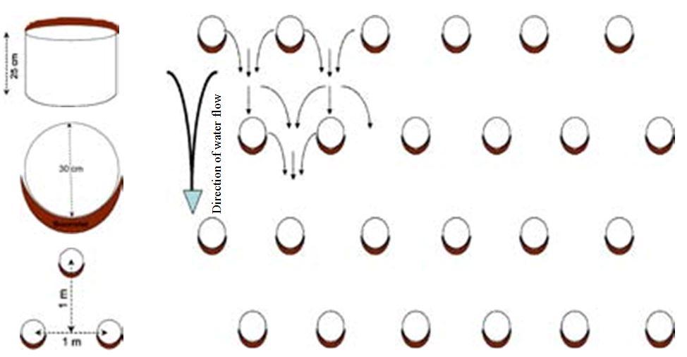
It involves digging planting pits with a diameter of at least 30 to 40 cm and 10 to 15 cm deep. They are spaced 70 to 80 cm apart, resulting in around 10,000 pits per hectare. Staggered rows of holes are dug perpendicularly to the slope. The earth dug out of the hole is piled up to form a small ridge around the rim, which captures water. A couple of handfuls of organic fertiliser or compost are put into each pit.
Location: Niger
Technical knowledge required for field staff / advisors: moderate
Technical knowledge required for land users: low
Main technical functions: control of dispersed runoff: retain / trap, control of dispersed runoff: impede / retard, control of concentrated runoff: retain / trap, control of concentrated runoff: impede / retard, increase in organic matter, increase in nutrient availability (supply, recycling,…), increase of infiltration, increase / maintain water stored in soil, water harvesting / increase water supply, sediment retention / trapping, sediment harvesting
Secondary technical functions: improvement of ground cover, stabilisation of soil (eg by tree roots against land slides), reduction in wind speed
Retention/infiltration ditch/pit, sediment/sand trap
Spacing between structures (m): 0.7-0.8
Depth of ditches/pits/dams (m): 0.15
Length of ditches/pits/dams (m): 0.3-0.4
Author:
PASP
4.2 General information regarding the calculation of inputs and costs
other/ national currency (specify):
CFA Franc
4.3 Establishment activities
| Activity | Timing (season) | |
|---|---|---|
| 1. | marking out the rows perpendicular to the slope | |
| 2. | digging pits in staggered rows | |
| 3. | forming a ridge on the downhill side | |
| 4. | A couple of handfuls of organic fertiliser or compost are put into each pit |
4.4 Costs and inputs needed for establishment
| Specify input | Unit | Quantity | Costs per Unit | Total costs per input | % of costs borne by land users | |
|---|---|---|---|---|---|---|
| Labour | labour | 1.0 | 16.3 | 16.3 | ||
| Labour | transport and planting trees | 1.0 | 12.3 | 12.3 | ||
| Equipment | machine use | 1.0 | 23.6 | 23.6 | ||
| Plant material | seedlings | |||||
| Total costs for establishment of the Technology | 52.2 | |||||
| Total costs for establishment of the Technology in USD | 52.2 | |||||
4.5 Maintenance/ recurrent activities
| Activity | Timing/ frequency | |
|---|---|---|
| 1. | the pits are prepared each year or once every two years (using the same pits or making new ones in the spaces between the old ones | |
| 2. | applying organic fertiliser every two years (1 to 2 hand-fuls per pit, amounting to around 3 tonnes per hectare). |
4.7 Most important factors affecting the costs
Describe the most determinate factors affecting the costs:
Labour: 40 to 60 man-days per hectare
• marking out the rows perpendicular to the slope
• digging pits in staggered rows
• forming a ridge on the downhill side
• applying organic fertiliser every two years (1 to 2 handfuls per pit, amounting to around 3 tonnes per hectare).
Other costs: transportation of 30 cartloads of manure.
5. Natural and human environment
5.1 Climate
Annual rainfall
- < 250 mm
- 251-500 mm
- 501-750 mm
- 751-1,000 mm
- 1,001-1,500 mm
- 1,501-2,000 mm
- 2,001-3,000 mm
- 3,001-4,000 mm
- > 4,000 mm
Agro-climatic zone
- semi-arid
Thermal climate class: subtropics
5.2 Topography
Slopes on average:
- flat (0-2%)
- gentle (3-5%)
- moderate (6-10%)
- rolling (11-15%)
- hilly (16-30%)
- steep (31-60%)
- very steep (>60%)
Landforms:
- plateau/plains
- ridges
- mountain slopes
- hill slopes
- footslopes
- valley floors
Altitudinal zone:
- 0-100 m a.s.l.
- 101-500 m a.s.l.
- 501-1,000 m a.s.l.
- 1,001-1,500 m a.s.l.
- 1,501-2,000 m a.s.l.
- 2,001-2,500 m a.s.l.
- 2,501-3,000 m a.s.l.
- 3,001-4,000 m a.s.l.
- > 4,000 m a.s.l.
5.3 Soils
Soil depth on average:
- very shallow (0-20 cm)
- shallow (21-50 cm)
- moderately deep (51-80 cm)
- deep (81-120 cm)
- very deep (> 120 cm)
Soil texture (topsoil):
- medium (loamy, silty)
- fine/ heavy (clay)
Topsoil organic matter:
- low (<1%)
If available, attach full soil description or specify the available information, e.g. soil type, soil PH/ acidity, Cation Exchange Capacity, nitrogen, salinity etc.
Soil texture: Fine to medium (sandy to clayey loams)
Soil fertility: Very low to medium
Soil drainage/infiltration: Poor and medium (ranked 2)
Soil water storage capacity: Low and medium (ranked 2)
5.4 Water availability and quality
Ground water table:
5-50 m
Availability of surface water:
medium
Water quality (untreated):
for agricultural use only (irrigation)
5.5 Biodiversity
Species diversity:
- low
5.6 Characteristics of land users applying the Technology
Market orientation of production system:
- subsistence (self-supply)
Relative level of wealth:
- very poor
- poor
Level of mechanization:
- manual work
- animal traction
Gender:
- men
Indicate other relevant characteristics of the land users:
Population density: 10-50 persons/km2
Annual population growth: 3% - 4% (mostly poor households below poverty line).
Off-farm income specification: men migrate temporarily or permanently to cities for off-farm income, women and men seasonally carry out paid farm work
Market orientation of production system: subsistence (self-supply, Most households crop for subsistence, mainly for small agropastoralists ), mixed (subsistence/commercial, crop surplus is sold on market, medium agropastoralists) and commercial market (Some vegetable growing, pastoralists)
Level of mechanization: Menual work (ranked 1) and animal traction (ranked 2, ox, donkey)
5.7 Average area of land used by land users applying the Technology
- < 0.5 ha
- 0.5-1 ha
- 1-2 ha
- 2-5 ha
- 5-15 ha
- 15-50 ha
- 50-100 ha
- 100-500 ha
- 500-1,000 ha
- 1,000-10,000 ha
- > 10,000 ha
Is this considered small-, medium- or large-scale (referring to local context)?
- small-scale
5.8 Land ownership, land use rights, and water use rights
Comments:
traditional land use rights prevail. On fields individual land use rights, communal rights on pasture and forest land (collection of wood and other products (fruits, medicinal plants))
5.9 Access to services and infrastructure
health:
- poor
- moderate
- good
education:
- poor
- moderate
- good
technical assistance:
- poor
- moderate
- good
employment (e.g. off-farm):
- poor
- moderate
- good
markets:
- poor
- moderate
- good
energy:
- poor
- moderate
- good
roads and transport:
- poor
- moderate
- good
drinking water and sanitation:
- poor
- moderate
- good
financial services:
- poor
- moderate
- good
6. Impacts and concluding statements
6.1 On-site impacts the Technology has shown
Socio-economic impacts
Production
crop production
risk of production failure
production area
Income and costs
farm income
workload
Socio-cultural impacts
food security/ self-sufficiency
SLM/ land degradation knowledge
Improved livelihoods and human well-being
Comments/ specify:
Plots with zai planting pits (with fertiliser) average yields of 409 kg of millet grain per hectare, compared to 195 kg per hectare registered on control plots. Millet yields can therefore be doubled with this technique. They also reduce the vulnerability of plants during dry spells and droughts, ensuring crop production and improving food security.
Ecological impacts
Water cycle/ runoff
surface runoff
Soil
soil moisture
soil cover
nutrient cycling/ recharge
soil organic matter/ below ground C
Biodiversity: vegetation, animals
plant diversity
Climate and disaster risk reduction
wind velocity
Other ecological impacts
Waterlogging in planting pits after heavy rains
6.2 Off-site impacts the Technology has shown
downstream flooding
downstream siltation
6.3 Exposure and sensitivity of the Technology to gradual climate change and climate-related extremes/ disasters (as perceived by land users)
Gradual climate change
Gradual climate change
| Season | increase or decrease | How does the Technology cope with it? | |
|---|---|---|---|
| annual temperature | increase | well |
Climate-related extremes (disasters)
Meteorological disasters
| How does the Technology cope with it? | |
|---|---|
| local rainstorm | not well |
| local windstorm | well |
Climatological disasters
| How does the Technology cope with it? | |
|---|---|
| drought | well |
Hydrological disasters
| How does the Technology cope with it? | |
|---|---|
| general (river) flood | not well |
Other climate-related consequences
Other climate-related consequences
| How does the Technology cope with it? | |
|---|---|
| reduced growing period | not known |
6.4 Cost-benefit analysis
How do the benefits compare with the establishment costs (from land users’ perspective)?
Short-term returns:
positive
Long-term returns:
very positive
How do the benefits compare with the maintenance/ recurrent costs (from land users' perspective)?
Short-term returns:
very positive
Long-term returns:
very positive
6.7 Strengths/ advantages/ opportunities of the Technology
| Strengths/ advantages/ opportunities in the compiler’s or other key resource person’s view |
|---|
| The arrangement of the pits in staggered rows ensures the most efficient collection of rainwater and slows the flow of water over the surface. The zai technique concentrates and conserves nutrients and water near the roots of the plants grown in them. |
| Zai planting pits are particularly useful in areas where land use pressure is high, as they permit the rehabilitation of unproductive land for farming. Therefore they lessen the pressure to clear other land for farming. |
| They also reduce the vulnerability of plants during dry spells and droughts, ensuring crop production and im- proving food security. |
| It permits a rational use of fertiliser. When fertiliser is spread on the surface of a plot without zai planting pits, it can be washed away by runoff. |
| very simple to implement and easily mastered by the farmers |
6.8 Weaknesses/ disadvantages/ risks of the Technology and ways of overcoming them
| Weaknesses/ disadvantages/ risks in the compiler’s or other key resource person’s view | How can they be overcome? |
|---|---|
| The zai technique requires high labour input. | |
| Zai planting pits are not recommended for light soils, as they fill in too quickly |
7. References and links
7.1 Methods/ sources of information
- field visits, field surveys
- interviews with land users
When were the data compiled (in the field)?
01/07/2012
7.3 Links to relevant online information
Title/ description:
Good Practices in Soil and Water Conservation. A contribution to adaptation and farmers´ resilience towards climate change in the Sahel. Published by GIZ in 2012.
URL:
http://agriwaterpedia.info/wiki/Main_Page
Links and modules
Expand all Collapse allLinks
No links
Modules
No modules