Zhuanglang loess terraces [China]
- Creation:
- Update:
- Compiler: Yaolin Wang
- Editor: –
- Reviewers: David Streiff, Deborah Niggli, Alexandra Gavilano
technologies_1419 - China
View sections
Expand all Collapse all1. General information
1.2 Contact details of resource persons and institutions involved in the assessment and documentation of the Technology
SLM specialist:
SLM specialist:
Zhanguo Zhanguo
ISRIC
Netherlands
SLM specialist:
Name of project which facilitated the documentation/ evaluation of the Technology (if relevant)
Book project: where the land is greener - Case Studies and Analysis of Soil and Water Conservation Initiatives Worldwide (where the land is greener)Name of the institution(s) which facilitated the documentation/ evaluation of the Technology (if relevant)
ISRIC World Soil Information (ISRIC World Soil Information) - NetherlandsName of the institution(s) which facilitated the documentation/ evaluation of the Technology (if relevant)
Department of Resources and Environmental Science, Beijing Normal University (Department of Resources and Environmental Science, Beijing Normal University) - ChinaName of the institution(s) which facilitated the documentation/ evaluation of the Technology (if relevant)
GEF/OP12 Gansu Project (GEF/OP12 Gansu Project) - China1.3 Conditions regarding the use of data documented through WOCAT
The compiler and key resource person(s) accept the conditions regarding the use of data documented through WOCAT:
Ja
1.5 Reference to Questionnaire(s) on SLM Approaches (documented using WOCAT)
Terrace approach [China]
Highly organised campaign to assist land users in creating terraces: support and planning from national down to local level.
- Compiler: Yaolin Wang
2. Description of the SLM Technology
2.1 Short description of the Technology
Definition of the Technology:
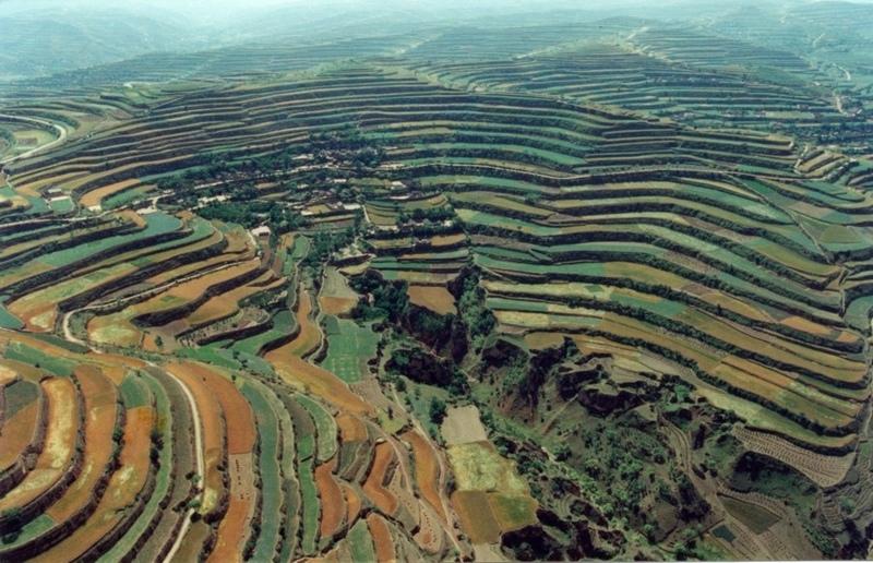
Level bench terraces on the Loess Plateau, converting eroded and degraded sloping land into a series of steps suitable for cultivation.
2.2 Detailed description of the Technology
Description:
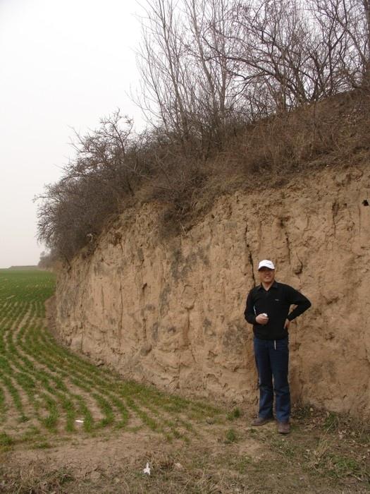
The Loess Plateau in north-central China is characterised by very deep loess parent material (up to 200 m), that is highly erodible and the source of most of the sediment in the lower reaches of the Yellow River.
The plateau is highly dissected by deep gullied valleys and gorges. The steep slopes, occupying 30-40% of the plateau area, have been heavily degraded by severe top soil and gully erosion. Over the whole Loess Plateau approximately 73,350 km2 of these erosion prone slopes have been conserved by terraces.
In the case study area (Zhuanglang County) the land that is suitable for terracing has been completely covered. The total terraced area is 1,088 km2, accounting for 90% of the hillsides. The terraces were constructed manually, starting at the bottom of the slopes and proceeding from valley to the ridge. The terraces comprise a riser of earth, with vertical or steeply sloping sides and an approximately flat bed (level bench). Depending on farmers preference some terrace beds are edged by a raised lip (a small earth ridge) which retains rainwater, others remain without lip. The semi-arid climate does not require a drainage system. For typical hillside terraces on slopes of 25-35% the bed width is about 3.5-5 metres with a 1-2 metre riser, involving moving about 2,000-2,500 cubic metres of soil (see table of technical specifications). Generally the risers are not specifically protected, but there may be some natural grasses growing on the upper part. The lower part of the riser is cut vertically into the original soil surface, and has no grass cover, being dry and compact. However it is not erosion-prone since it has a stable structure.
Over most of the Loess Plateau, the soil is very deep and therefore well suited to terrace construction. In addition to downstream benefits, the purpose is to create a better environment for crop production through improved moisture conservation, and improved ease of farming operations. In an average rainfall year, crop yields on terraced land are more than three times higher than they used to be on unterraced, sloping land. The implication is that terrace construction - though labour intensive - pays back in only three to four years when combined with agronomic improvements (such as applying farm yard manure and planting green manure). Some farmers try to make the best use of the upper part of terrace risers by planting cash trees or forage crops - including Hippophae rhamnoides (seabuckthorn), Caragana korshinskii (peashrub) and some leguminous grass. This is locally termed ‘terrace bund economy’. The plants stabilise the risers and at the same time provides extra benefits.
2.3 Photos of the Technology
Media Gallery
2.5 Country/ region/ locations where the Technology has been applied and which are covered by this assessment
Country:
China
Region/ State/ Province:
Gansu Province (Loess Plateau Region)
Further specification of location:
Zhuanglang County
Specify the spread of the Technology:
- evenly spread over an area
If the Technology is evenly spread over an area, specify area covered (in km2):
1080.0
Comments:
Total area covered by the SLM Technology is 1080 km2.
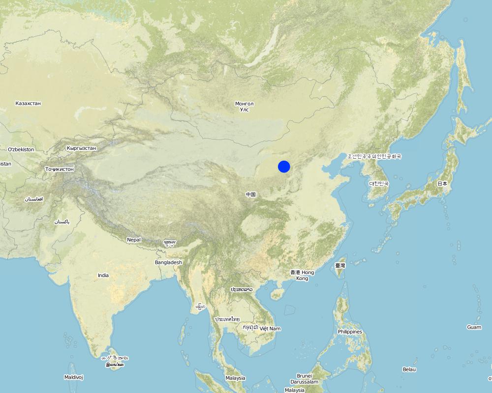
Map
×2.7 Introduction of the Technology
Specify how the Technology was introduced:
- through projects/ external interventions
3. Classification of the SLM Technology
3.2 Current land use type(s) where the Technology is applied
Land use mixed within the same land unit:
Ja
Specify mixed land use (crops/ grazing/ trees):
- Agroforestry

Cropland
- Annual cropping
- Tree and shrub cropping
Annual cropping - Specify crops:
- cereals - maize
- cereals - millet
- cereals - sorghum
- legumes and pulses - peas
- root/tuber crops - potatoes
- wheat
Tree and shrub cropping - Specify crops:
- pome fruits (apples, pears, quinces, etc.)
- stone fruits (peach, apricot, cherry, plum, etc)
- tree nuts (brazil nuts, pistachio, walnuts, almonds, etc.)
Number of growing seasons per year:
- 1
Specify:
Longest growing period in days: 160Longest growing period from month to month: May to September
Comments:
major cash crops: peas
major food crops: wheat, maize, potato, millet, sorghum
perrenial tree and shrub cropping: apple, pear and peach; walnut
Major land use problems (compiler’s opinion): Cultivation of unterraced hillside slopes leads to serious soil erosion and problems of downstream sedimentation.
Loss of topsoil and rainwater in uncontrolled runoff has contributed to declining crop yields.
3.4 Water supply
Water supply for the land on which the Technology is applied:
- rainfed
3.5 SLM group to which the Technology belongs
- cross-slope measure
- terraces
3.6 SLM measures comprising the Technology

structural measures
- S1: Terraces
Comments:
Main measures: structural measures
3.7 Main types of land degradation addressed by the Technology

soil erosion by water
- Wt: loss of topsoil/ surface erosion
- Wg: gully erosion/ gullying
- Wo: offsite degradation effects

chemical soil deterioration
- Cn: fertility decline and reduced organic matter content (not caused by erosion)

water degradation
- Ha: aridification
Comments:
Main type of degradation addressed: Wt: loss of topsoil / surface erosion, Wg: gully erosion / gullying, Wo: offsite degradation effects, Cn: fertility decline and reduced organic matter content, Ha: aridification
Main causes of degradation: soil management (Absence or bad maintenance of erosion control measures), other human induced causes (specify), poverty / wealth (Lack of captial), education, access to knowledge and support services (Lack of knowledge)
Secondary causes of degradation: labour availability (Lack of labour)
3.8 Prevention, reduction, or restoration of land degradation
Specify the goal of the Technology with regard to land degradation:
- restore/ rehabilitate severely degraded land
Comments:
Main goals: rehabilitation / reclamation of denuded land
4. Technical specifications, implementation activities, inputs, and costs
4.1 Technical drawing of the Technology
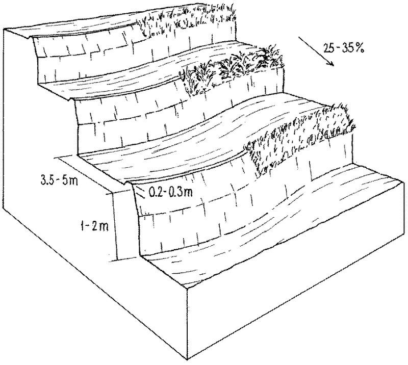
Technical specifications (related to technical drawing):
Layout of level bench terraces on the Loess Plateau: the lower, vertical section is cut into the compacted soil. Natural grasses -
or planted grass/ shrub species - protect the more erodible and less steep upper part of the riser. The low ‘lip’ is optional.
Technical knowledge required for field staff / advisors: high
Technical knowledge required for land users: low
Main technical functions: reduction of slope angle, reduction of slope length, increase of infiltration, increase / maintain water stored in soil, water harvesting / increase water supply, retains runoff in-situ, reduces downstream flooding, reduces sediment deposition (a national/regional concern)
Structural measure: level bench terraces
Height of bunds/banks/others (m): 1-2
Width of bunds/banks/others (m): 3.5-5
Construction material (earth): loess parent material
Slope (which determines the spacing indicated above): 30%
Author:
Mats Gurtner
4.2 General information regarding the calculation of inputs and costs
Specify how costs and inputs were calculated:
- per Technology area
Indicate size and area unit:
ha
Specify currency used for cost calculations:
- USD
4.3 Establishment activities
| Activity | Timing (season) | |
|---|---|---|
| 1. | Contour lines are marked out using pegs to show the location for the base of each terrace wall | - |
| 2. | A trench is dug out along the marked line to serve as the foundation | |
| 3. | A trench is dug out along the marked line to serve as the foundation | - |
| 4. | The topsoil between the pegged lines is removed and put aside | |
| 5. | See Annex T3: alternative ways of constructing the wall/riser, bed | |
| 6. | The wall is raised slightly higher to form a lip to retain rainwater on the | - |
4.4 Costs and inputs needed for establishment
| Specify input | Unit | Quantity | Costs per Unit | Total costs per input | % of costs borne by land users | |
|---|---|---|---|---|---|---|
| Labour | Voluntary and paid (building terraces) | ha | 1.0 | 1200.0 | 1200.0 | 97.0 |
| Labour | survey of labour | ha | 1.0 | 60.0 | 60.0 | |
| Equipment | tools | ha | 1.0 | 30.0 | 30.0 | 100.0 |
| Construction material | earth | ha | 1.0 | |||
| Total costs for establishment of the Technology | 1290.0 | |||||
| Total costs for establishment of the Technology in USD | 1290.0 | |||||
Comments:
Duration of establishment phase: 4 month(s)
4.5 Maintenance/ recurrent activities
| Activity | Timing/ frequency | |
|---|---|---|
| 1. | 1. Repairing any collapses in the terrace wall – often caused by heavy | |
| 2. | 2. Re-levelling of the terraces where necessary. This work is usually done by hand, using shovels and two-wheel carts. |
4.6 Costs and inputs needed for maintenance/ recurrent activities (per year)
| Specify input | Unit | Quantity | Costs per Unit | Total costs per input | % of costs borne by land users | |
|---|---|---|---|---|---|---|
| Labour | Reparing terraces | ha | 1.0 | 25.0 | 25.0 | 97.0 |
| Equipment | tools | ha | 1.0 | 10.0 | 10.0 | |
| Construction material | earth | ha | 1.0 | |||
| Total costs for maintenance of the Technology | 35.0 | |||||
| Total costs for maintenance of the Technology in USD | 35.0 | |||||
Comments:
Calculations above are based on the following situation: slopes of about 25-35%, bed width of 3.5-6 m, and a 1-2 m high riser, involving moving about 2,000-2,500 cubic metres of soil. Note: these calculations are based on several years experience in Zhuanglang: that is why they differ in some respects from the standardised table in 2.4.1.
5. Natural and human environment
5.1 Climate
Annual rainfall
- < 250 mm
- 251-500 mm
- 501-750 mm
- 751-1,000 mm
- 1,001-1,500 mm
- 1,501-2,000 mm
- 2,001-3,000 mm
- 3,001-4,000 mm
- > 4,000 mm
Agro-climatic zone
- semi-arid
5.2 Topography
Slopes on average:
- flat (0-2%)
- gentle (3-5%)
- moderate (6-10%)
- rolling (11-15%)
- hilly (16-30%)
- steep (31-60%)
- very steep (>60%)
Landforms:
- plateau/plains
- ridges
- mountain slopes
- hill slopes
- footslopes
- valley floors
Altitudinal zone:
- 0-100 m a.s.l.
- 101-500 m a.s.l.
- 501-1,000 m a.s.l.
- 1,001-1,500 m a.s.l.
- 1,501-2,000 m a.s.l.
- 2,001-2,500 m a.s.l.
- 2,501-3,000 m a.s.l.
- 3,001-4,000 m a.s.l.
- > 4,000 m a.s.l.
Indicate if the Technology is specifically applied in:
- not relevant
Comments and further specifications on topography:
Slopes on average: also rolling
Altitudinal zone: 501- 2000 m a.s.l.
Landforms: Also ridges
5.3 Soils
Soil depth on average:
- very shallow (0-20 cm)
- shallow (21-50 cm)
- moderately deep (51-80 cm)
- deep (81-120 cm)
- very deep (> 120 cm)
Soil texture (topsoil):
- medium (loamy, silty)
Topsoil organic matter:
- low (<1%)
If available, attach full soil description or specify the available information, e.g. soil type, soil PH/ acidity, Cation Exchange Capacity, nitrogen, salinity etc.
Soil fertility: low-medium
Soil drainage / infiltration: good
5.6 Characteristics of land users applying the Technology
Market orientation of production system:
- mixed (subsistence/ commercial)
Off-farm income:
- 10-50% of all income
Individuals or groups:
- individual/ household
Indicate other relevant characteristics of the land users:
Off-farm income specification: working in construction, temporary employments
Market orientation mixed (subsistence and commercial): ash crop (peas) and food crops (potatoes, wheat, maize, millet, sorghum)
5.7 Average area of land used by land users applying the Technology
- < 0.5 ha
- 0.5-1 ha
- 1-2 ha
- 2-5 ha
- 5-15 ha
- 15-50 ha
- 50-100 ha
- 100-500 ha
- 500-1,000 ha
- 1,000-10,000 ha
- > 10,000 ha
Is this considered small-, medium- or large-scale (referring to local context)?
- small-scale
Comments:
Average area of land owned or leased by land users applying the Technology: < 0.5 ha, 0.5-1 ha, 1-2 ha
5.8 Land ownership, land use rights, and water use rights
Land ownership:
- state
Land use rights:
- individual
6. Impacts and concluding statements
6.1 On-site impacts the Technology has shown
Socio-economic impacts
Production
crop production
Income and costs
farm income
Other socio-economic impacts
easier field operation
production during the first year of implementation
Socio-cultural impacts
community institutions
conflict mitigation
Ecological impacts
Soil
soil moisture
soil loss
6.2 Off-site impacts the Technology has shown
reliable and stable stream flows in dry season
downstream flooding
downstream siltation
transported sediments
6.4 Cost-benefit analysis
How do the benefits compare with the establishment costs (from land users’ perspective)?
Short-term returns:
negative
Long-term returns:
very positive
How do the benefits compare with the maintenance/ recurrent costs (from land users' perspective)?
Short-term returns:
positive
Long-term returns:
very positive
6.5 Adoption of the Technology
If available, quantify (no. of households and/ or area covered):
NA
Comments:
There is no trend towards spontaneous adoption of the Technology
Comments on adoption trend: - The technology was implemented on a large scale through government initiated mass campaigns.
- The technology has generally not spontaneously spread beyond the areas developed through government intervention: the area that is suitable for terracing has been covered.
- Uncertainty over future land use rights limits the willingness of households to meet the costs of terrace construction.
6.7 Strengths/ advantages/ opportunities of the Technology
| Strengths/ advantages/ opportunities in the land user’s view |
|---|
| Diversification of production: terracing makes cultivation of new cash crops possible: flax (for linseed oil), pears, apples, apricots, water melon; all these give high returns and thus make terrace construction profitable. |
| Benefits pay back the investments after only three to four years; approx. calculated on the basis of US$ 450 extra income per annum per hectare (for wheat) vs US$ 1,200 labour investment per hectare. |
| Strengths/ advantages/ opportunities in the compiler’s or other key resource person’s view |
|---|
|
Reduced erosion, reduced loss of rainwater through runoff (increased in water use efficiency) and reduced fertility loss due to reduced slope angle and length How can they be sustained / enhanced? Maintain the quality of terrace construction. |
|
Increased soil moisture How can they be sustained / enhanced? Construct/maintain a terrace lip to retain rainwater on the terrace |
|
Increased crop production (before 1983 hunger and starvation in the area) How can they be sustained / enhanced? Combine with improved crop husbandry. |
| Easier field operations: the level terrace is easier to cultivate than the original hill slope. |
| Improvements of farmers’ living standard and decline in poverty stricken population. |
6.8 Weaknesses/ disadvantages/ risks of the Technology and ways of overcoming them
| Weaknesses/ disadvantages/ risks in the compiler’s or other key resource person’s view | How can they be overcome? |
|---|---|
| Terrace riser can be destroyed by storms – and, sometimes, rodent holes | Good and timely repair and maintenance: planting upper parts of the risers with grass, bushes or even trees help to stabilise the risers but can lead to competition with the crop for water. |
| High cost/input for construction and establishment | Given the high erodibility of the soil and the steep slopes there is no real alternatives to labour-intensive terracing. |
| High loss of soil moisture due to evaporation from the soil surface. Wind erosion due to tillage | Protect soil surface for example by conservation agriculture – comprising permanent cover, crop rotation, reduced tillage – could be supplementary agronomic and vegetative options. |
| Decrease in production in first year | Apply manure and fertilizer. |
7. References and links
7.1 Methods/ sources of information
7.2 References to available publications
Title, author, year, ISBN:
Terraces In China. Published By Ministry Of Water Resources Beijing, PRC.. 1989.
Title, author, year, ISBN:
Conservancy engineering budgetary estimateration. Issued by Ministry of water resources of PRC, Published by Yellow-river water conservancy publishing company, Zhengzhou, PRC. 2003.
Title, author, year, ISBN:
A Great Cause for Centuries – 50 Years in Water and Soil Conservation in China. Published by Department of Soil and Water Conservation, Ministry ofWater Resources Beijing, PRC. 2000.
Title, author, year, ISBN:
Dongyinglin, Changpiguang, Wangzhihua: Discussion on several questions onincreasing production of the terrace with two banks; Soil and Water Conservation Science and Technology in Shanxi. No. 1, p 36–37. 1990.
Title, author, year, ISBN:
Liumingquan, Zhangaiqin, Liyouhua:Pattern engineering of reconstruction the slope cropland; Soil and Water Conservation Science and Technology in Shanxi,No. 3, p 18–21. 1992.
Title, author, year, ISBN:
Liangqichun, Changfushuang, Liming: A study on drawing up budgetary estimate quota of terraced field; Bulletin of Soil andWater Conservation, Vol. 21, No. 5, p 41–44. 2001.
Title, author, year, ISBN:
Lixuelian, Qiaojiping: Synthetic technology of fertilizing and improving production on the newterrace. Terraces in China. Soil and Water Conservation Science and Technology in Shanxi, No. 3, p 13–14. 1998.
Links and modules
Expand all Collapse allLinks
Terrace approach [China]
Highly organised campaign to assist land users in creating terraces: support and planning from national down to local level.
- Compiler: Yaolin Wang
Modules
No modules