Pasture management of a communal grazing land [Tajikistan]
- Creation:
- Update:
- Compiler: Malgorzata Conder
- Editor: –
- Reviewers: David Streiff, Alexandra Gavilano
technologies_1555 - Tajikistan
View sections
Expand all Collapse all1. General information
1.2 Contact details of resource persons and institutions involved in the assessment and documentation of the Technology
SLM specialist:
Name of the institution(s) which facilitated the documentation/ evaluation of the Technology (if relevant)
CDE Centre for Development and Environment (CDE Centre for Development and Environment) - SwitzerlandName of the institution(s) which facilitated the documentation/ evaluation of the Technology (if relevant)
CARITAS (Switzerland) - Switzerland1.3 Conditions regarding the use of data documented through WOCAT
The compiler and key resource person(s) accept the conditions regarding the use of data documented through WOCAT:
Ja
2. Description of the SLM Technology
2.1 Short description of the Technology
Definition of the Technology:
Pasture management of a communal land through daily rotation
2.2 Detailed description of the Technology
Description:
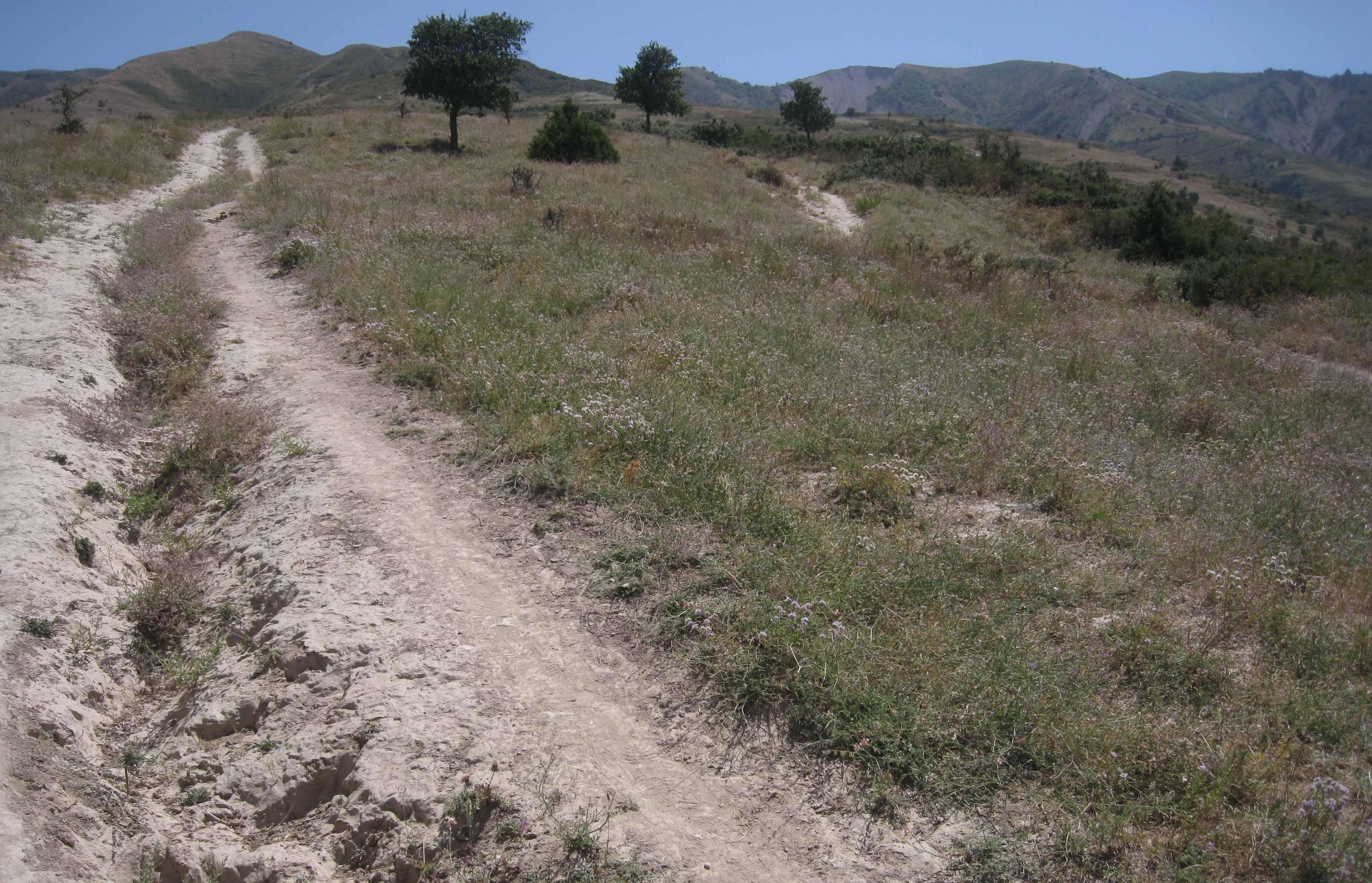
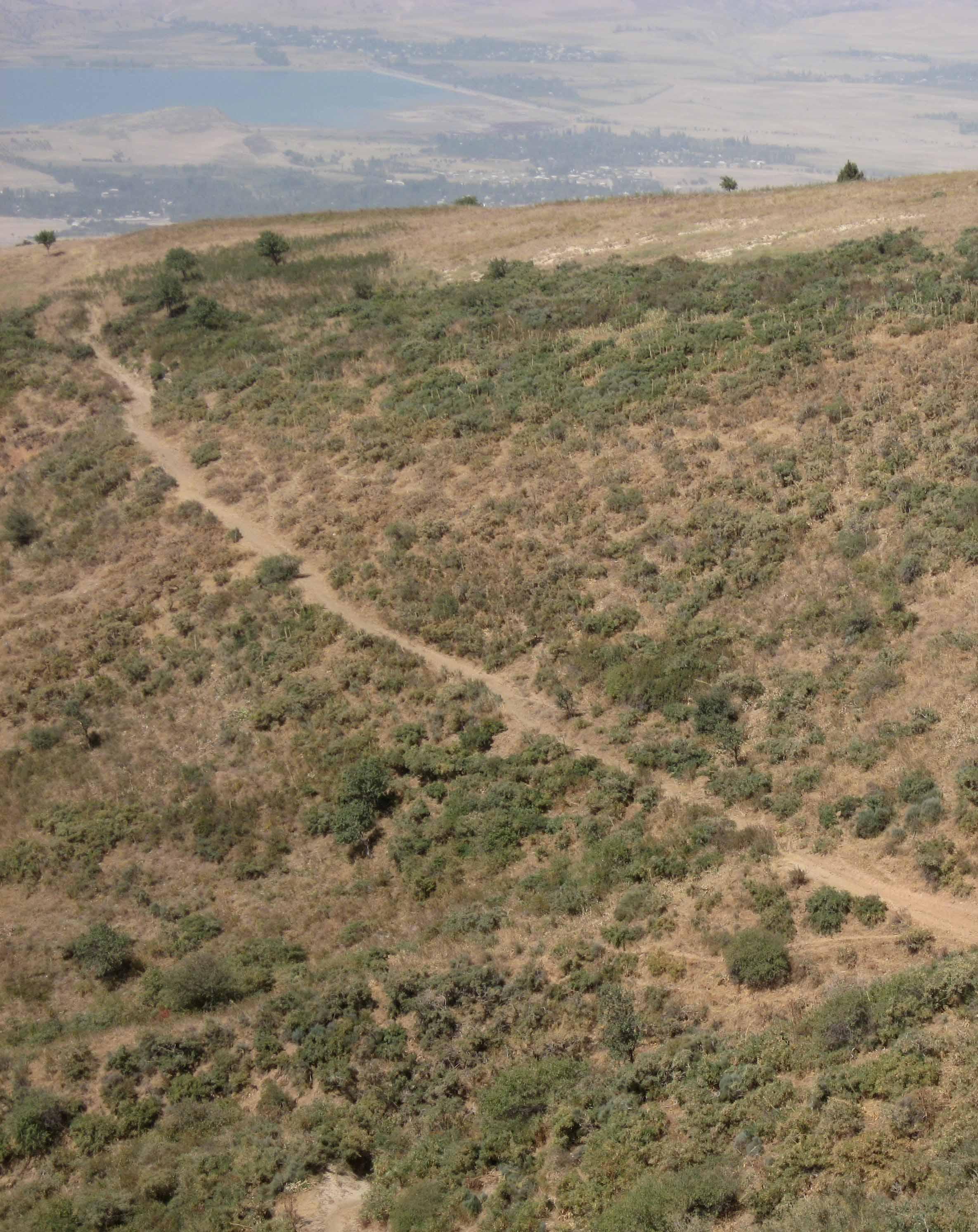
The total area of the pasture accounts for 300 – 500 ha. The pasture is property of the Doshmand village but it includes also some private properties, mainly potato and wheat crops. After the harvest, livestock is also grazing on these crops. Eighteen households are currently using the pasture with a total of 150 cows and 500 small animals. Additionally, three groups of herds from other villages graze irregularly on this pasture mainly on the lateral parts as it is less guarded by the villagers. The interviewee estimates that over 1000 cows, goats and sheep are coming from other villages. Other herds cross this pasture when migrating to or coming back from the summer pasture in spring and autumn, respectively. Nevertheless Doshmand residents claim that this intrusive grazing is accepted as “every animal has to be fed”. This shows the need of a pasture management not only on village but also on watershed level.
During Soviet time the inhabitants of Doshmand were forced to migrate to the valley. In 2003, the resettlement of the ancient location started with two families. Simultaneously, the pasture management was established and joined by each family who resettled. The controlled area is divided in 4 subparts. The herd switches daily within them. Every household looks after the herd for a day, which results in a rotational cycle of 18 days. There are no fixed and regular meetings for pasture management within the village pasture. However, two subsequent herders communicate to know where the herd has been grazing and where to graze the next time.
Purpose of the Technology: Purpose of the rotational grazing is to graze on one subpart, while the three other areas are resting. This reduces the impact of grazed and trampled areas per subpart and allows the growth and recovery of the vegetation in the other parts.
The task of herding is shared among the families. The rotational grazing is organized orally and freely, why it’s not sure if that approach is strictly binding. Discussions about pasture management rise only in case of need.
Establishment / maintenance activities and inputs: Doshmand village got the pasture in a good condition at the time of establishment. Vegetation cover was high. The only investment consisted in building a water point for the livestock. A further investment was to buy a water pipe and dig out a channel for the pipe to conduct the water from the water point to the village. Money was collected by the families and many villagers were involved in digging the channel.
No further input was and is required except coordination between the herders.
Natural / human environment: The pasture of Doshmand village is located in the middle and upper zone of the watershed. Thanks to the distance to other settlements, the pasture is less affected by overgrazing than other communal pastures in the watershed. Nevertheless, the pasture is heterogeneously grazed, with some areas which are difficult to access even for livestock and hence abundant vegetation. Other areas, especially those situated next to the village show a more bare vegetation cover.
2.3 Photos of the Technology
Media Gallery
2.5 Country/ region/ locations where the Technology has been applied and which are covered by this assessment
Country:
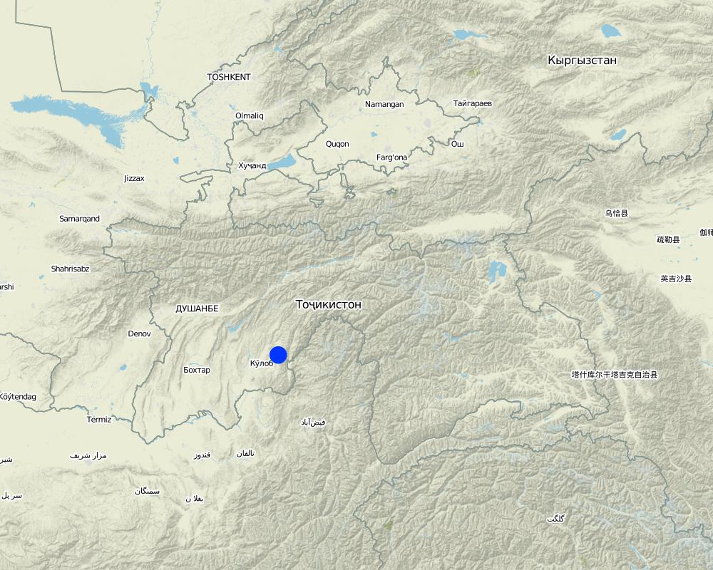
Tajikistan
Region/ State/ Province:
Khatlon, Tajikistan
Further specification of location:
Muminabad
Specify the spread of the Technology:
- evenly spread over an area
If precise area is not known, indicate approximate area covered:
- 1-10 km2
Comments:
Total area covered by the SLM Technology is 4 km2.
The Vakil (village representant) was not sure about the area, between 300 to 500 ha.
Map
×2.6 Date of implementation
If precise year is not known, indicate approximate date:
- 10-50 years ago
2.7 Introduction of the Technology
Specify how the Technology was introduced:
- through land users' innovation
3. Classification of the SLM Technology
3.1 Main purpose(s) of the Technology
- reduce, prevent, restore land degradation
- conserve ecosystem
3.2 Current land use type(s) where the Technology is applied

Cropland
- Annual cropping
Annual cropping - Specify crops:
- cereals - wheat (spring)
- cereals - wheat (winter)
- root/tuber crops - potatoes
Number of growing seasons per year:
- 1
Specify:
Longest growing period in days: 160Longest growing period from month to month: April-Sept

Grazing land
Extensive grazing:
- Semi-nomadic pastoralism
- rotational grazing
Comments:
Livestock density (if relevant):
> 100 LU /km2
Major land use problems (compiler’s opinion): Erosion
Overgrazing
Major land use problems (land users’ perception): increase of unpalatable vegetation
Semi-nomadism / pastoralism: Yes
Grazingland comments: Mainly summer pasture, normally no grazing from November/ December to February/ March
Type of grazing system comments: Mainly summer pasture, normally no grazing from November/ December to February/ March
3.4 Water supply
Water supply for the land on which the Technology is applied:
- rainfed
3.5 SLM group to which the Technology belongs
- pastoralism and grazing land management
3.6 SLM measures comprising the Technology

management measures
- M2: Change of management/ intensity level
Comments:
Main measures: management measures
3.7 Main types of land degradation addressed by the Technology

soil erosion by water
- Wo: offsite degradation effects

chemical soil deterioration
- Cn: fertility decline and reduced organic matter content (not caused by erosion)

physical soil deterioration
- Pc: compaction

biological degradation
- Bc: reduction of vegetation cover
- Bs: quality and species composition/ diversity decline
Comments:
Main type of degradation addressed: Wo: offsite degradation effects, Pc: compaction, Bc: reduction of vegetation cover
Secondary types of degradation addressed: Cn: fertility decline and reduced organic matter content, Bs: quality and species composition /diversity decline
Main causes of degradation: overgrazing, land tenure (communal grazing land also used by other communes)
Secondary causes of degradation: deforestation / removal of natural vegetation (incl. forest fires), disturbance of water cycle (infiltration / runoff)
3.8 Prevention, reduction, or restoration of land degradation
Specify the goal of the Technology with regard to land degradation:
- reduce land degradation
- restore/ rehabilitate severely degraded land
Comments:
Main goals: rehabilitation / reclamation of denuded land
Secondary goals: mitigation / reduction of land degradation
4. Technical specifications, implementation activities, inputs, and costs
4.1 Technical drawing of the Technology
Technical specifications (related to technical drawing):
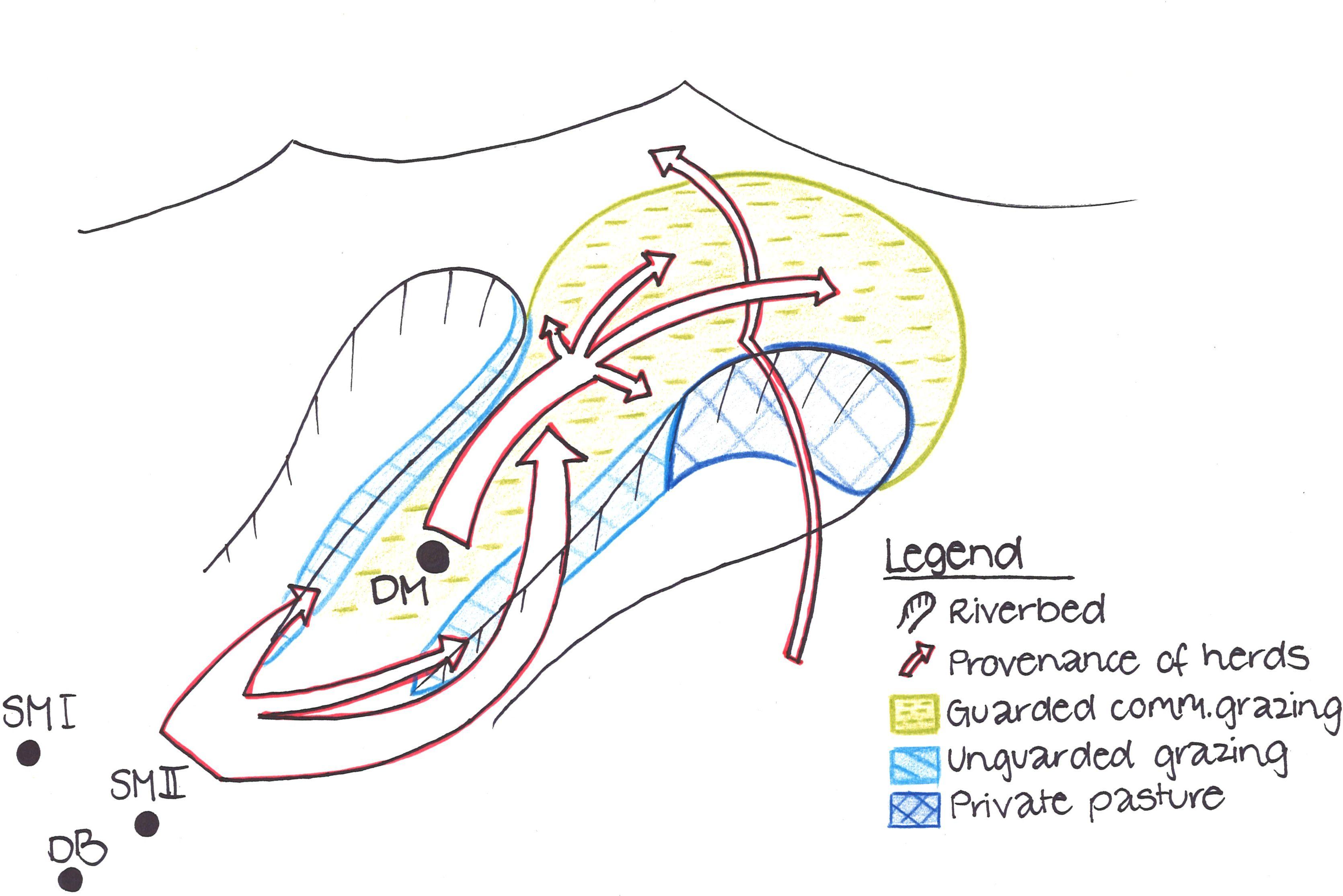
Livestock from Doshmand village (DM) is grazing in the four subparts of the communal pasture. Livestock from other villages, located in the valley Sarmadoni I (SMI) and II (SMII) and Dehibaland (DB), can invade the guarded and unguarded communal pasture of Doschmand. In spring and autumn also other livestock crosses Doshmand's pasture when migrating to or leaving the summer pasture.
Location: Chukurak watershed. Muminabad, Khatlon
Technical knowledge required for land users: low
Main technical functions: improvement of ground cover, increase of infiltration
Secondary technical functions: improvement of topsoil structure (compaction), stabilisation of soil (eg by tree roots against land slides), increase in organic matter
Change of land use practices / intensity level: Rotational grazing at village level
Author:
Malgorzata Conder
4.2 General information regarding the calculation of inputs and costs
Specify currency used for cost calculations:
- USD
Indicate average wage cost of hired labour per day:
12.40
4.3 Establishment activities
| Activity | Timing (season) | |
|---|---|---|
| 1. | Coordination with villagers and herders | Reestablishment of village |
4.4 Costs and inputs needed for establishment
| Specify input | Unit | Quantity | Costs per Unit | Total costs per input | % of costs borne by land users | |
|---|---|---|---|---|---|---|
| Labour | Coordination with villagers and herders | - | 1.0 |
4.5 Maintenance/ recurrent activities
| Activity | Timing/ frequency | |
|---|---|---|
| 1. | Consultation with village herders | If needed |
4.6 Costs and inputs needed for maintenance/ recurrent activities (per year)
| Specify input | Unit | Quantity | Costs per Unit | Total costs per input | % of costs borne by land users | |
|---|---|---|---|---|---|---|
| Labour | Consultation with village herders | - | 1.0 |
4.7 Most important factors affecting the costs
Describe the most determinate factors affecting the costs:
There are no costly factors, the most important input is a good planning, coordination and consistent execution of the rotational grazing system.
The installation of a waterpoint would be needed but it is a very costly installation.
5. Natural and human environment
5.1 Climate
Annual rainfall
- < 250 mm
- 251-500 mm
- 501-750 mm
- 751-1,000 mm
- 1,001-1,500 mm
- 1,501-2,000 mm
- 2,001-3,000 mm
- 3,001-4,000 mm
- > 4,000 mm
Specifications/ comments on rainfall:
Annual rainfall (1,001-1,500 mm): Totally 800mm: 700mm in winter-spring, July-Sept dry season (At 1200mm asl, weather station Muminabad)
Annual rainfall (1,501-2,000 mm): Precipitation increases 60mm per 100m of altitude in average. Here up to 1600mm.
Agro-climatic zone
- sub-humid
Thermal climate class: temperate
LPG from April until September
5.2 Topography
Slopes on average:
- flat (0-2%)
- gentle (3-5%)
- moderate (6-10%)
- rolling (11-15%)
- hilly (16-30%)
- steep (31-60%)
- very steep (>60%)
Landforms:
- plateau/plains
- ridges
- mountain slopes
- hill slopes
- footslopes
- valley floors
Altitudinal zone:
- 0-100 m a.s.l.
- 101-500 m a.s.l.
- 501-1,000 m a.s.l.
- 1,001-1,500 m a.s.l.
- 1,501-2,000 m a.s.l.
- 2,001-2,500 m a.s.l.
- 2,501-3,000 m a.s.l.
- 3,001-4,000 m a.s.l.
- > 4,000 m a.s.l.
Comments and further specifications on topography:
Slopes on average (steep): Some flanks up to approx. 40%
5.3 Soils
Soil depth on average:
- very shallow (0-20 cm)
- shallow (21-50 cm)
- moderately deep (51-80 cm)
- deep (81-120 cm)
- very deep (> 120 cm)
Soil texture (topsoil):
- medium (loamy, silty)
- fine/ heavy (clay)
Topsoil organic matter:
- high (>3%)
- medium (1-3%)
If available, attach full soil description or specify the available information, e.g. soil type, soil PH/ acidity, Cation Exchange Capacity, nitrogen, salinity etc.
Topsoil organic matter (high): On some flanks with high vegetation cover, which are difficult to access by livestock
Soil fertility is low
Soil drainage / infiltration is medium
Soil water storage capacity is low near the villages and high on mountain slopes (off-village)
5.4 Water availability and quality
Ground water table:
5-50 m
Availability of surface water:
medium
Water quality (untreated):
poor drinking water (treatment required)
Comments and further specifications on water quality and quantity:
Water quality (untreated) is also for agricultural use only (irrigation)
5.5 Biodiversity
Species diversity:
- high
5.6 Characteristics of land users applying the Technology
Market orientation of production system:
- subsistence (self-supply)
Off-farm income:
- less than 10% of all income
Relative level of wealth:
- average
Individuals or groups:
- groups/ community
Gender:
- women
- men
Indicate other relevant characteristics of the land users:
Land users applying the Technology are mainly common / average land users
Population density: 100-200 persons/km2
Annual population growth: 1% - 2%
5.7 Average area of land used by land users applying the Technology
- < 0.5 ha
- 0.5-1 ha
- 1-2 ha
- 2-5 ha
- 5-15 ha
- 15-50 ha
- 50-100 ha
- 100-500 ha
- 500-1,000 ha
- 1,000-10,000 ha
- > 10,000 ha
Is this considered small-, medium- or large-scale (referring to local context)?
- small-scale
Comments:
Around 3 ha, if 7.7 pers/household of totally 2350 ha pasture
5.8 Land ownership, land use rights, and water use rights
Land ownership:
- state
Land use rights:
- leased
Water use rights:
- communal (organized)
Comments:
Land ownership is based on the land user certificate conferred by the government
5.9 Access to services and infrastructure
health:
- poor
- moderate
- good
education:
- poor
- moderate
- good
technical assistance:
- poor
- moderate
- good
employment (e.g. off-farm):
- poor
- moderate
- good
markets:
- poor
- moderate
- good
energy:
- poor
- moderate
- good
roads and transport:
- poor
- moderate
- good
drinking water and sanitation:
- poor
- moderate
- good
financial services:
- poor
- moderate
- good
6. Impacts and concluding statements
6.1 On-site impacts the Technology has shown
Socio-economic impacts
Production
fodder production
animal production
Comments/ specify:
Not the whole pastureland can be grazed at once
Water availability and quality
water availability for livestock
water quality for livestock
Socio-cultural impacts
food security/ self-sufficiency
community institutions
Livelihoods and human well-being
Comments/ specify:
Strenghtening of the community sense and awareness through increased coordination for rotational grazing between villagers. Higher fodder availability leads to healthier livestock.
Ecological impacts
Water cycle/ runoff
surface runoff
evaporation
Soil
soil moisture
soil crusting/ sealing
soil compaction
Biodiversity: vegetation, animals
biomass/ above ground C
Climate and disaster risk reduction
fire risk
Other ecological impacts
Hazards towards adverse events
6.2 Off-site impacts the Technology has shown
downstream siltation
buffering/ filtering capacity
damage on public/ private infrastructure
6.3 Exposure and sensitivity of the Technology to gradual climate change and climate-related extremes/ disasters (as perceived by land users)
Gradual climate change
Gradual climate change
| Season | increase or decrease | How does the Technology cope with it? | |
|---|---|---|---|
| annual temperature | increase | well |
Climate-related extremes (disasters)
Meteorological disasters
| How does the Technology cope with it? | |
|---|---|
| local rainstorm | not well |
| local windstorm | well |
Climatological disasters
| How does the Technology cope with it? | |
|---|---|
| drought | not well |
Hydrological disasters
| How does the Technology cope with it? | |
|---|---|
| general (river) flood | not well |
Other climate-related consequences
Other climate-related consequences
| How does the Technology cope with it? | |
|---|---|
| reduced growing period | not known |
Comments:
Conduct the rotational grazing even more strictly
6.4 Cost-benefit analysis
How do the benefits compare with the establishment costs (from land users’ perspective)?
Short-term returns:
neutral/ balanced
Long-term returns:
slightly positive
How do the benefits compare with the maintenance/ recurrent costs (from land users' perspective)?
Short-term returns:
neutral/ balanced
Long-term returns:
positive
6.5 Adoption of the Technology
If available, quantify (no. of households and/ or area covered):
NA
Comments:
There is a little trend towards spontaneous adoption of the Technology
Comments on adoption trend: Effort is made to introduce more rotational grazing on cummunity level in the region with institutional support.
6.7 Strengths/ advantages/ opportunities of the Technology
| Strengths/ advantages/ opportunities in the land user’s view |
|---|
| No big input, coordination between farmers exists anyway |
| Strengths/ advantages/ opportunities in the compiler’s or other key resource person’s view |
|---|
|
In a rotational grazing system at village level every family is responsible for the sustainability of the pasture How can they be sustained / enhanced? Give more responsability and co-determination to individuals |
|
High establishment potential as rotational grazing do not demand any costs, except coordination and organization on village level How can they be sustained / enhanced? Disseminate the idea of rotational grazing also on watershed level |
|
Ecologic benefits as high vegetation cover, less erosion etc. can be achieved without monetary investment How can they be sustained / enhanced? Spread knowledge of long-term effects by rotational grazing |
|
Being a pasture of a big area extent in the uphills, the good quality of the pasture plays an important role for all the settlements and cultivations downstream How can they be sustained / enhanced? Raise the awareness about the upstream-downstream interrelation in the watersheds |
6.8 Weaknesses/ disadvantages/ risks of the Technology and ways of overcoming them
| Weaknesses/ disadvantages/ risks in the compiler’s or other key resource person’s view | How can they be overcome? |
|---|---|
| In reality, rotational grazing is not executed strictly enough | Stricter separation of the subparts needed |
| Herds from other villages graze in the same pasture | Strenghten coordination of grazing between and within villages |
| Some flanks show high vegetation because they are not accessible for livestock and not because of the rotational grazing |
7. References and links
7.1 Methods/ sources of information
Links and modules
Expand all Collapse allLinks
No links
Modules
No modules