Trashlines [Kenya]
- Creation:
- Update:
- Compiler: Paul Kahiga
- Editor: –
- Reviewers: Fabian Ottiger, Alexandra Gavilano
Maraini ya Mavuti (Kiembu)
technologies_1735 - Kenya
View sections
Expand all Collapse all1. General information
1.2 Contact details of resource persons and institutions involved in the assessment and documentation of the Technology
SLM specialist:
Gathenya Mwangi
Jomo Kenyatta University of Agriculture and Technology
Kenya
SLM specialist:
Home Patrick
Jomo Kenyatta University of Agriculture and Technology
Kenya
SLM specialist:
Chege Timothy
Jomo Kenyatta University of Agriculture and Technology
Kenya
SLM specialist:
Wamuongo Jane
Kenya Agricultural Research Institute
Kenya
SLM specialist:
Karanja Andrew
Kenya Agricultural Research Institute
Kenya
Name of the institution(s) which facilitated the documentation/ evaluation of the Technology (if relevant)
KARI Headquarters (KARI Headquarters) - KenyaName of the institution(s) which facilitated the documentation/ evaluation of the Technology (if relevant)
Jomo Kenyatta University (Jomo Kenyatta University) - Kenya1.3 Conditions regarding the use of data documented through WOCAT
The compiler and key resource person(s) accept the conditions regarding the use of data documented through WOCAT:
Ja
1.4 Declaration on sustainability of the described Technology
Is the Technology described here problematic with regard to land degradation, so that it cannot be declared a sustainable land management technology?
Nee
2. Description of the SLM Technology
2.1 Short description of the Technology
Definition of the Technology:
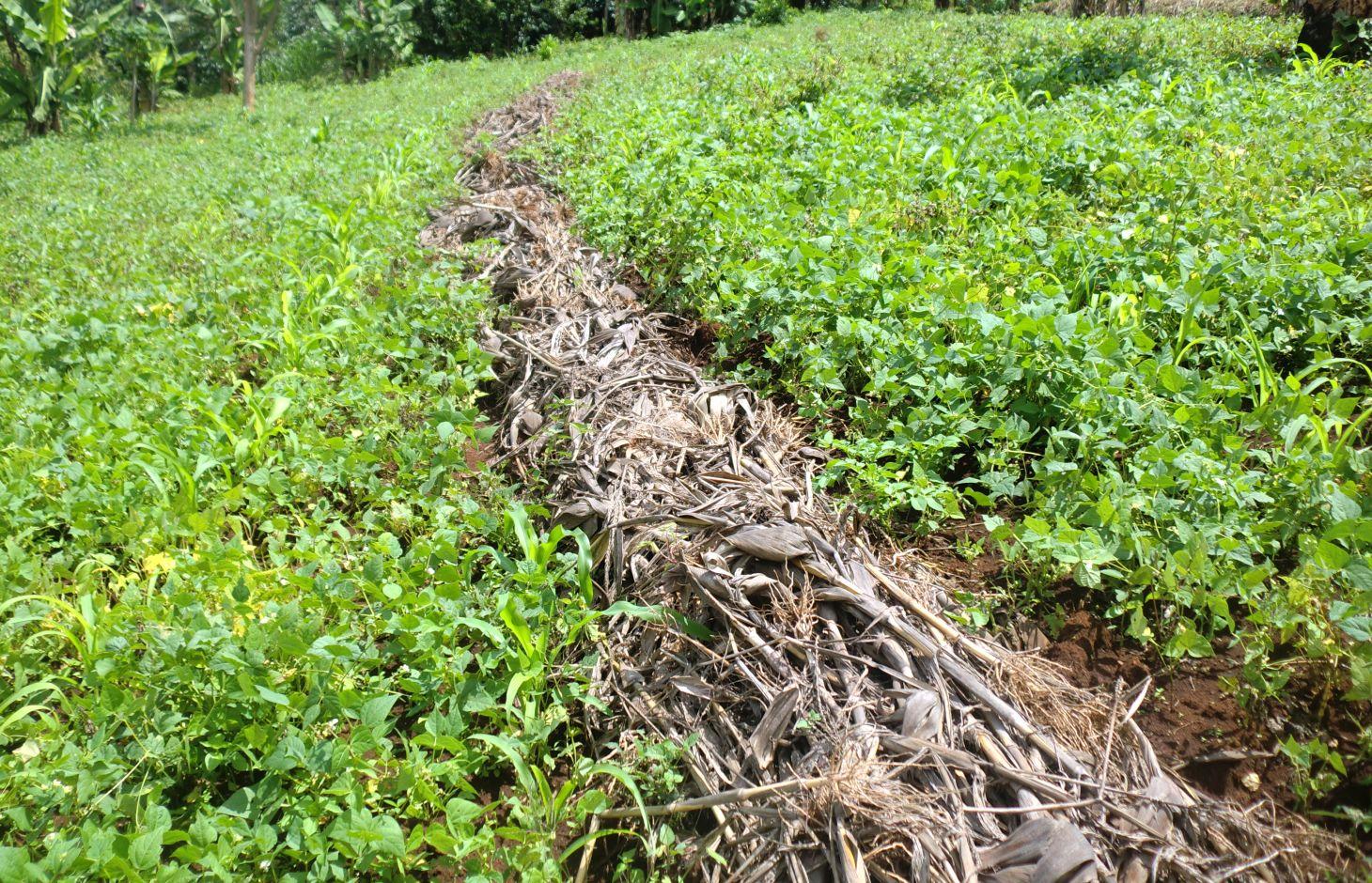
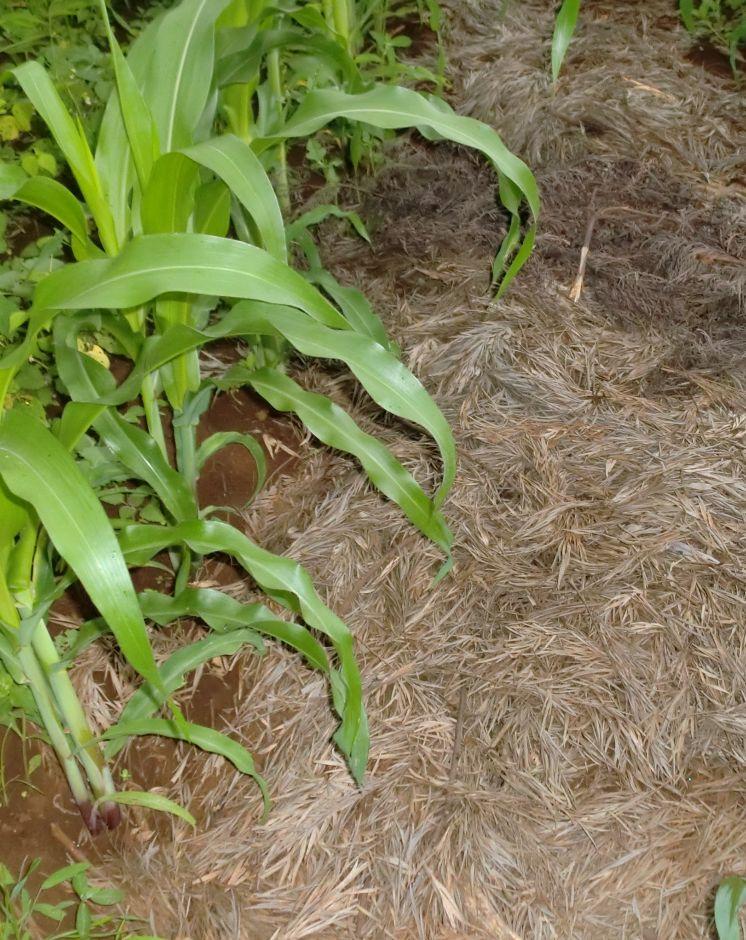
Trashlines are lines of crop residuals that remain after harvesting, they are formed along the contours.
2.2 Detailed description of the Technology
Description:
Trash lines are crop residues laid in bands across the slope of annual crop fields to conserve soil and water, and to incorporate organic matter into the soil after decomposition. They are formed into ridges across the slope to form semi permeable barriers that decrease the runoff velocity and increase the infiltration duration, but allow passage of excess runoff. They impede runoff and enhance infiltration. They also prevent evaporation of water from the soil thus conserving soil moisture. Different dimensions and spacing as practiced by farmers have given rise to different structures depending on availability of materials and tools. Thus there are large and small, fixed and mobile trash lines, spaced about 15 m apart. The position of most trash lines is not fixed but instead new trash is placed 3 to 5m up slope each season.
Purpose of the Technology: Trash lines allow water to infiltrate into the soil in the area directly beneath them, and require little labour to construct but frequent maintenance. Trash lines form semi-permeable barriers across the slope that decrease the surface runoff velocity and increase the infiltration duration of impounded water, but allow passage of excess runoff. As a result, the amount of infiltrated water increases and the runoff volume and its erosive power decrease. Additionally, retention of sediment in the trash results in reduced soil and nutrient losses. Trash lines require low labor.
Establishment / maintenance activities and inputs: Farmers in Embu utilizes the crop residuals after harvesting. The most common used type of crop residual used in Embu district is maize stovers that are left behind after harvesting. They are laid down in a row along the contour and left to decompose after sometime leaving a line of rich organic matter. They do very well when practiced with conservation agriculture. This is very common in the lower Mbeere District.
Natural / human environment: In other areas, cereal stover (straw) and weeds that are collected during primary cultivation (hand hoeing), and heaped in strips along the approximate contour are used as trash lines. Creeping grasses should not be used in trash lines, they can alternatively be decomposed in bundles, and then used as mulch in nearby banana plantations. Trash lines can also be constructed on hillside fields where annual crops, including sorghum, finger millet, beans and peas, are grown.The recommended spacing between the improved trash lines is 5–10 m, depending on the slope: the steeper the closer. The amount of material available determines the cross section of each trash line (typically ±0.5 m wide and ±0.3 m high).
2.3 Photos of the Technology
Media Gallery
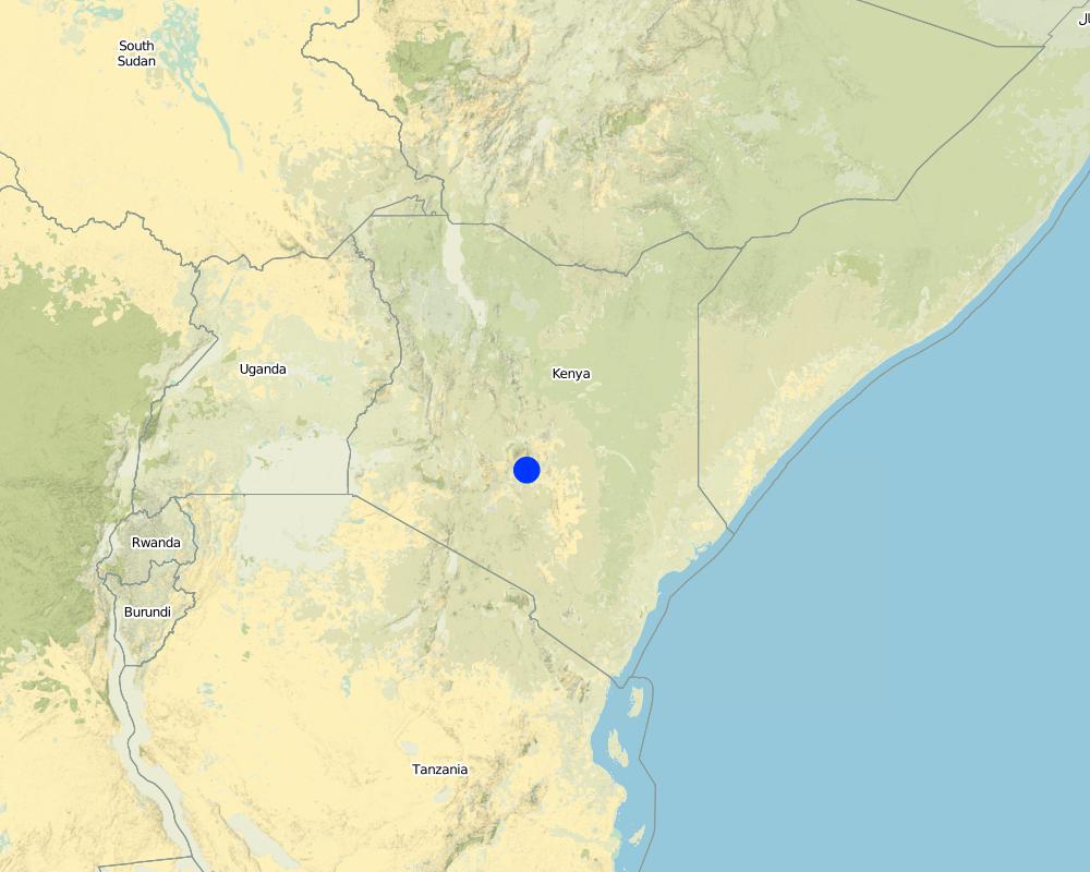
2.5 Country/ region/ locations where the Technology has been applied and which are covered by this assessment
Country:
Kenya
Region/ State/ Province:
Eastern Province
Further specification of location:
Embu North District
Specify the spread of the Technology:
- evenly spread over an area
If precise area is not known, indicate approximate area covered:
- 1-10 km2
Map
×2.6 Date of implementation
If precise year is not known, indicate approximate date:
- 10-50 years ago
2.7 Introduction of the Technology
Specify how the Technology was introduced:
- through land users' innovation
3. Classification of the SLM Technology
3.1 Main purpose(s) of the Technology
- improve production
- reduce, prevent, restore land degradation
- adapt to climate change/ extremes and its impacts
- create beneficial economic impact
3.2 Current land use type(s) where the Technology is applied

Cropland
- Annual cropping
- Tree and shrub cropping
Annual cropping - Specify crops:
- cereals - maize
- coffee
Specify:
Longest growing period in days: 180, Longest growing period from month to month: January to June
Comments:
Major land use problems (compiler’s opinion): Reduction of soil erosion and excessive evaporation
Major land use problems (land users’ perception): Increase of organic matter to increase nutrients
3.4 Water supply
Water supply for the land on which the Technology is applied:
- rainfed
3.5 SLM group to which the Technology belongs
- improved ground/ vegetation cover
- water harvesting
- irrigation management (incl. water supply, drainage)
3.6 SLM measures comprising the Technology

structural measures
- S6: Walls, barriers, palisades, fences
3.7 Main types of land degradation addressed by the Technology

soil erosion by water
- Wt: loss of topsoil/ surface erosion
Comments:
Main causes of degradation: soil management
3.8 Prevention, reduction, or restoration of land degradation
Specify the goal of the Technology with regard to land degradation:
- prevent land degradation
- reduce land degradation
4. Technical specifications, implementation activities, inputs, and costs
4.1 Technical drawing of the Technology
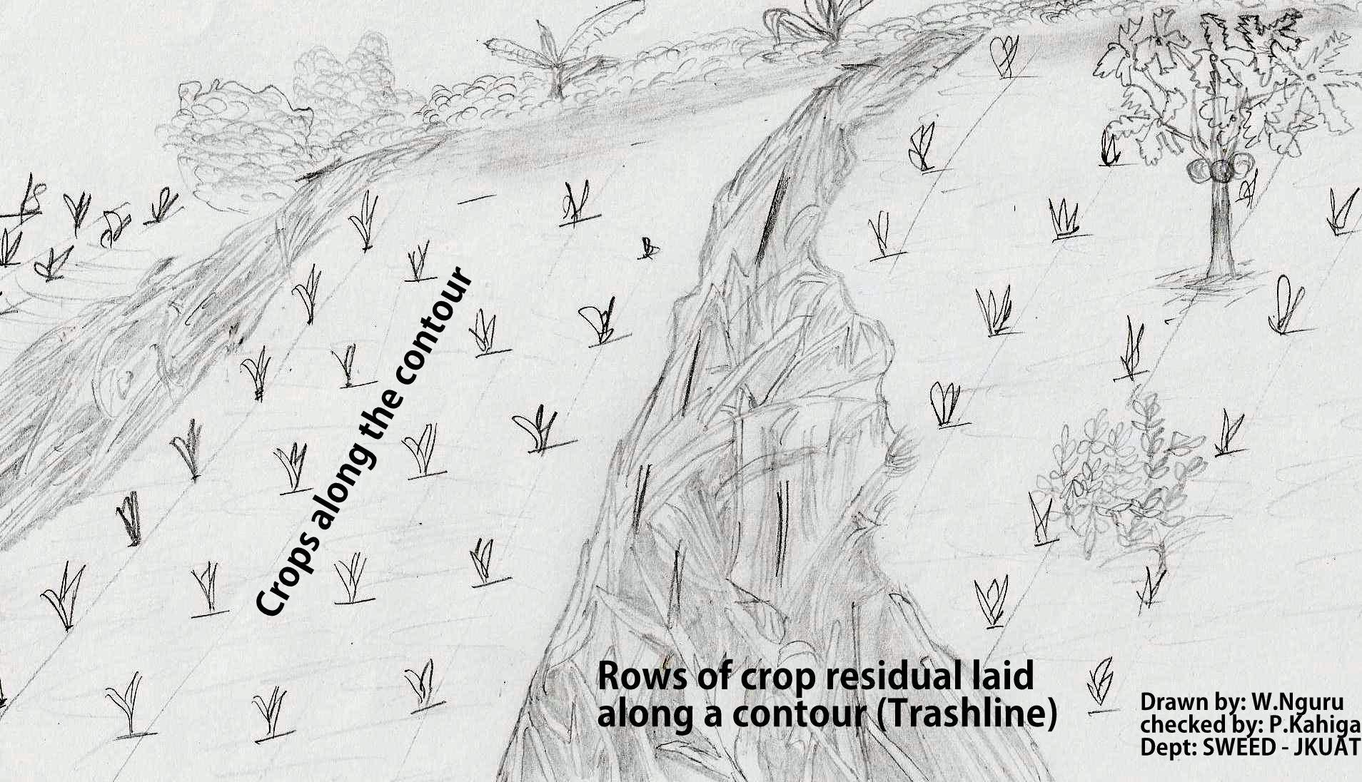
Technical specifications (related to technical drawing):
The technical drawing on the left side shows rows of maize stovers that are laid down along a contour line after harvesting.
Location: Embu North District. Eastern province
Date: 02/09/2011
Technical knowledge required for field staff / advisors: moderate
Technical knowledge required for land users: high
Main technical functions: control of dispersed runoff: retain / trap
Structural measure: Trashline
Vertical interval between structures (m): 5
Spacing between structures (m): 15
Height of bunds/banks/others (m): 0.5
Width of bunds/banks/others (m): 1
Length of bunds/banks/others (m): 30
Construction material (other): maize stovers
Slope (which determines the spacing indicated above): 8%
Author:
Paul Kahiga, 62000-00200 Nairobi
4.2 General information regarding the calculation of inputs and costs
other/ national currency (specify):
Kshs
If relevant, indicate exchange rate from USD to local currency (e.g. 1 USD = 79.9 Brazilian Real): 1 USD =:
100.0
Indicate average wage cost of hired labour per day:
4.00
4.3 Establishment activities
| Activity | Timing (season) | |
|---|---|---|
| 1. | Harvesting and cutting the stovers | When maize matures |
| 2. | Marking the contours | Before laying the stovers |
| 3. | Collecting the stovers and laying them along the marked contour |
4.4 Costs and inputs needed for establishment
| Specify input | Unit | Quantity | Costs per Unit | Total costs per input | % of costs borne by land users | |
|---|---|---|---|---|---|---|
| Labour | Harvesting and cutting the stovers | Mandays | 4.0 | 1.0 | 4.0 | 100.0 |
| Labour | Marking the contours | Mandays | 3.0 | 1.3333 | 4.0 | 100.0 |
| Labour | Collecting the stovers and laying them along the marked contour | Mandays | 4.0 | 1.0 | 4.0 | 100.0 |
| Equipment | Tools | Numbers | 4.0 | 1.25 | 5.0 | 100.0 |
| Plant material | Seeds | ha | 1.0 | 16.0 | 16.0 | 100.0 |
| Construction material | Maize stovers | ha | 1.0 | 100.0 | 100.0 | 100.0 |
| Total costs for establishment of the Technology | 133.0 | |||||
| Total costs for establishment of the Technology in USD | 1.33 | |||||
4.5 Maintenance/ recurrent activities
| Activity | Timing/ frequency | |
|---|---|---|
| 1. | Adding stovers in the next season | after every season |
4.6 Costs and inputs needed for maintenance/ recurrent activities (per year)
| Specify input | Unit | Quantity | Costs per Unit | Total costs per input | % of costs borne by land users | |
|---|---|---|---|---|---|---|
| Labour | Adding stovers in the next season | Mandays | 4.0 | 1.0 | 4.0 | 100.0 |
| Equipment | Tools | ha | 1.0 | 10.0 | 10.0 | 100.0 |
| Plant material | Seeds | ha | 1.0 | 8.0 | 8.0 | 100.0 |
| Construction material | Maize stovers | ha | 1.0 | 50.0 | 50.0 | 100.0 |
| Total costs for maintenance of the Technology | 72.0 | |||||
| Total costs for maintenance of the Technology in USD | 0.72 | |||||
Comments:
Machinery/ tools: Pangas
Labour
4.7 Most important factors affecting the costs
Describe the most determinate factors affecting the costs:
Availability of crop residuals and labour are the most determinate factors affecting the costs.
5. Natural and human environment
5.1 Climate
Annual rainfall
- < 250 mm
- 251-500 mm
- 501-750 mm
- 751-1,000 mm
- 1,001-1,500 mm
- 1,501-2,000 mm
- 2,001-3,000 mm
- 3,001-4,000 mm
- > 4,000 mm
Agro-climatic zone
- sub-humid
5.2 Topography
Slopes on average:
- flat (0-2%)
- gentle (3-5%)
- moderate (6-10%)
- rolling (11-15%)
- hilly (16-30%)
- steep (31-60%)
- very steep (>60%)
Landforms:
- plateau/plains
- ridges
- mountain slopes
- hill slopes
- footslopes
- valley floors
Altitudinal zone:
- 0-100 m a.s.l.
- 101-500 m a.s.l.
- 501-1,000 m a.s.l.
- 1,001-1,500 m a.s.l.
- 1,501-2,000 m a.s.l.
- 2,001-2,500 m a.s.l.
- 2,501-3,000 m a.s.l.
- 3,001-4,000 m a.s.l.
- > 4,000 m a.s.l.
5.3 Soils
Soil depth on average:
- very shallow (0-20 cm)
- shallow (21-50 cm)
- moderately deep (51-80 cm)
- deep (81-120 cm)
- very deep (> 120 cm)
Soil texture (topsoil):
- medium (loamy, silty)
Topsoil organic matter:
- medium (1-3%)
If available, attach full soil description or specify the available information, e.g. soil type, soil PH/ acidity, Cation Exchange Capacity, nitrogen, salinity etc.
Soil fertility: High
Soil drainage/infiltration: Good
Soil water storage capacity: Medium
5.4 Water availability and quality
Ground water table:
5-50 m
Availability of surface water:
medium
Water quality (untreated):
poor drinking water (treatment required)
5.5 Biodiversity
Species diversity:
- medium
5.6 Characteristics of land users applying the Technology
Market orientation of production system:
- mixed (subsistence/ commercial)
Off-farm income:
- less than 10% of all income
Relative level of wealth:
- average
Individuals or groups:
- individual/ household
Level of mechanization:
- manual work
Gender:
- women
- men
Indicate other relevant characteristics of the land users:
Land users applying the Technology are mainly common / average land users
Population density: 10-50 persons/km2
Annual population growth: 0.5% - 1%
70% of the land users are average wealthy.
5.7 Average area of land used by land users applying the Technology
- < 0.5 ha
- 0.5-1 ha
- 1-2 ha
- 2-5 ha
- 5-15 ha
- 15-50 ha
- 50-100 ha
- 100-500 ha
- 500-1,000 ha
- 1,000-10,000 ha
- > 10,000 ha
Is this considered small-, medium- or large-scale (referring to local context)?
- small-scale
5.8 Land ownership, land use rights, and water use rights
Land ownership:
- individual, titled
Land use rights:
- individual
Water use rights:
- open access (unorganized)
5.9 Access to services and infrastructure
health:
- poor
- moderate
- good
education:
- poor
- moderate
- good
6. Impacts and concluding statements
6.1 On-site impacts the Technology has shown
Socio-economic impacts
Production
crop production
fodder production
risk of production failure
Socio-cultural impacts
SLM/ land degradation knowledge
Improved livelihoods and human well-being
Comments/ specify:
A healthy crop stand produces high yields.
Ecological impacts
Water cycle/ runoff
water quality
surface runoff
Soil
soil loss
Biodiversity: vegetation, animals
biomass/ above ground C
6.3 Exposure and sensitivity of the Technology to gradual climate change and climate-related extremes/ disasters (as perceived by land users)
Gradual climate change
Gradual climate change
| Season | increase or decrease | How does the Technology cope with it? | |
|---|---|---|---|
| annual temperature | increase | well |
Comments:
Farmers in the lower Mbeere District have been uprooting maize stovers to increase weight so as to prevent the trash being carried away by strong wind
6.4 Cost-benefit analysis
How do the benefits compare with the establishment costs (from land users’ perspective)?
Short-term returns:
positive
Long-term returns:
positive
How do the benefits compare with the maintenance/ recurrent costs (from land users' perspective)?
Short-term returns:
positive
Long-term returns:
positive
6.5 Adoption of the Technology
Comments:
There is a moderate trend towards spontaneous adoption of the Technology
6.7 Strengths/ advantages/ opportunities of the Technology
| Strengths/ advantages/ opportunities in the compiler’s or other key resource person’s view |
|---|
| Trashlines reduces soil erosion by trapping the sediments |
| Increase of organic matter in the soil after decomposition |
| Establishment of trashlines doesn't need alot of labour. |
6.8 Weaknesses/ disadvantages/ risks of the Technology and ways of overcoming them
| Weaknesses/ disadvantages/ risks in the compiler’s or other key resource person’s view | How can they be overcome? |
|---|---|
| When crop residuals are used for establishment of trashlines, this leads to reduction of fodder for farm animals | planting of fodder crops instead of relying on maize stocks alone |
| The trash lines harbors pests, they are also associated with termite infestation especially in the dry areas of Mbeere south District | Alternative methods of controlling pests should be put in place |
7. References and links
7.1 Methods/ sources of information
- field visits, field surveys
- interviews with land users
When were the data compiled (in the field)?
09/02/2011
Links and modules
Expand all Collapse allLinks
No links
Modules
No modules