
Revitalization of Riparian Zones [Switzerland]
- Creation:
- Update:
- Compiler: Nives Ramisberger
- Editors: Joana Eichenberger, Tatenda Lemann, Nadja Kollbrunner
- Reviewers: Rima Mekdaschi Studer, William Critchley
(FR) revitalisation de la zone riparienne, (DE) Revitalisierung des Gewässerraums
technologies_6248 - Switzerland
View sections
Expand all Collapse all1. General information
1.2 Contact details of resource persons and institutions involved in the assessment and documentation of the Technology
Key resource person(s)
SLM specialist:
Devanthéry Julien
CSDIngenieurs
Switzerland
SLM specialist:
Friedli Audrey
Broye Source de Vie
Switzerland
Name of project which facilitated the documentation/ evaluation of the Technology (if relevant)
OPtimal strategies to retAIN and re-use water and nutrients in small agricultural catchments across different soil-climatic regions in Europe (OPTAIN)Name of the institution(s) which facilitated the documentation/ evaluation of the Technology (if relevant)
CDE Centre for Development and Environment (CDE Centre for Development and Environment) - SwitzerlandName of the institution(s) which facilitated the documentation/ evaluation of the Technology (if relevant)
University of Bern, Institute of Geography (GIUB) - Switzerland1.3 Conditions regarding the use of data documented through WOCAT
The compiler and key resource person(s) accept the conditions regarding the use of data documented through WOCAT:
Ja
1.4 Declaration on sustainability of the described Technology
Is the Technology described here problematic with regard to land degradation, so that it cannot be declared a sustainable land management technology?
Nee
2. Description of the SLM Technology
2.1 Short description of the Technology
Definition of the Technology:
The riparian zone is the buffer area between a watercourse and the adjacent land. Healthy riparian ecosystems stabilise the banks, maintain the microclimate, protect against flooding, filter chemicals and improve both biodiversity and water quality.
2.2 Detailed description of the Technology
Description:
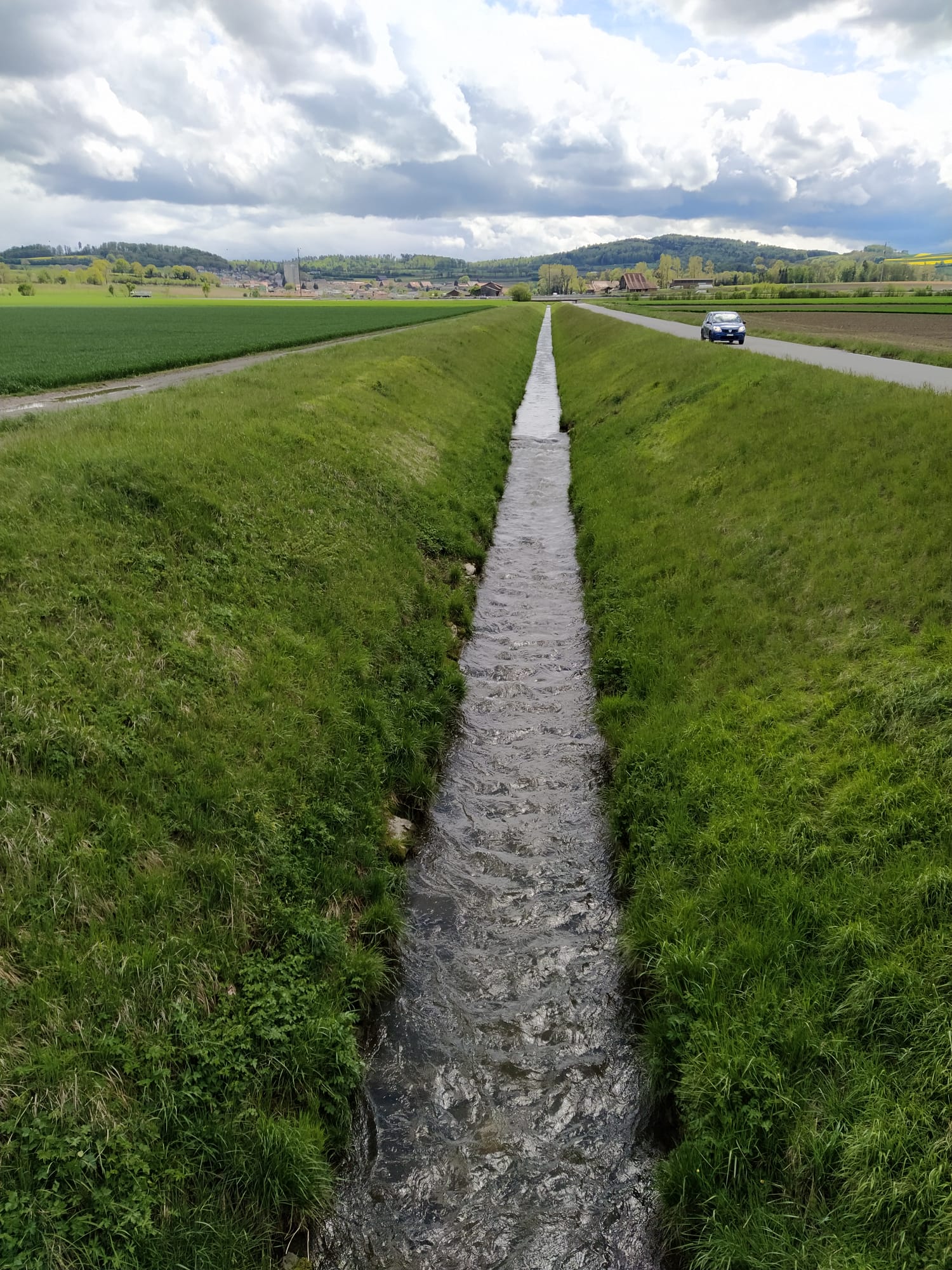
In the 19th and early 20th centuries nearly all Swiss rivers were "corrected" (straightened, channelised and diked) to reduce flood damage and reclaim land for agriculture. In the late 20th century the adverse effects of these corrections became increasingly clear, and there was a paradigm shift towards more sustainable river management. There are many current “revitalization” projects, among them the restoration of the Petite Glâne, which started in 2022 and is expected to be completed in 2026. The project perimeter consists of the last 7 kilometres of the Petite Glâne stream and the costs are estimated at CHF 21.5 million.
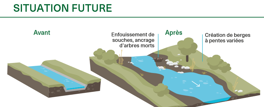
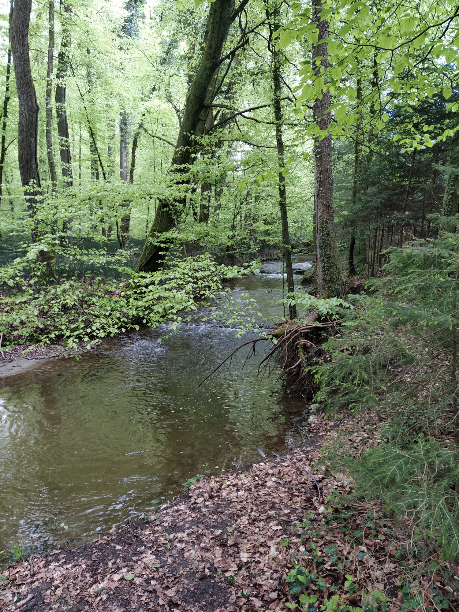
The main characteristics of revitalization are widening the riverbed and reducing the slopes of the riverbanks, thus giving the river space for meandering and changing the morphology in a natural way. Where riparian forests do not occur naturally anymore, it can make sense to re-establish them so that biodiversity can flourish. The planting of trees and bushes gives many animals a habitat and can serve as a wildlife corridor between different areas. Additionally, shading of the water reduces its temperature fluctuations which - especially in summer - is important to many species that are dependent on cold water for their survival. With climate change this threat will become even worse. The main purpose of revitalization is to recreate near-natural conditions in artificially straightened reaches to ensure provision of riparian ecosystem services.
Considerable planning is involved in implementing this technology in Switzerland partly because of legal reasons (watercourses are closely protected and land rights require negotiation) and because effects on downstream areas need to be taken into account. Depending on the length of the river segment where riparian forests are to be restored, there are many stakeholders involved, all of whom need to give their approval: this takes time and effort. Inputs are mostly in the form of trees and bushes. Depending on the degree of revitalization, built-up river sections need to be freed again and infrastructure like bridges, buildings and roads may be affected. In theory, there is no maintenance necessary because revitalized rivers are intended to reassume their natural form and be surrounded by natural vegetation. Nevertheless, in a highly modified and intensely used landscape, the cutting of grass and pruning of trees/bushes on a regular basis can be required. Wood harvesting may be an option. Driftwood might also have to be removed if there is danger of flooding or clogging of bottlenecks – for example under bridges.
Revitalization, theoretically, has larger effects on smaller rivers than on bigger ones due to a greater proportion of land draining into them compared to their size. Additionally, shading has larger effects on the water temperature of smaller rivers. Benefits accruing are mainly in regard to habitat provision and thus biodiversity enhancement, but also improvement of water quality (lower temperatures, less nutrient input) and water management in general as flooding is expected to be less frequent. A key disadvantage is that the measures are often implemented at the expense of agricultural land. Naturally, farmers are usually unhappy about the loss of land - even though alternative agricultural plots and direct payments are provided. In general, however, people appreciate the improvement in the quality of life (a pleasanter area for leisure) and improved biodiversity.
2.3 Photos of the Technology
Media Gallery
2.5 Country/ region/ locations where the Technology has been applied and which are covered by this assessment
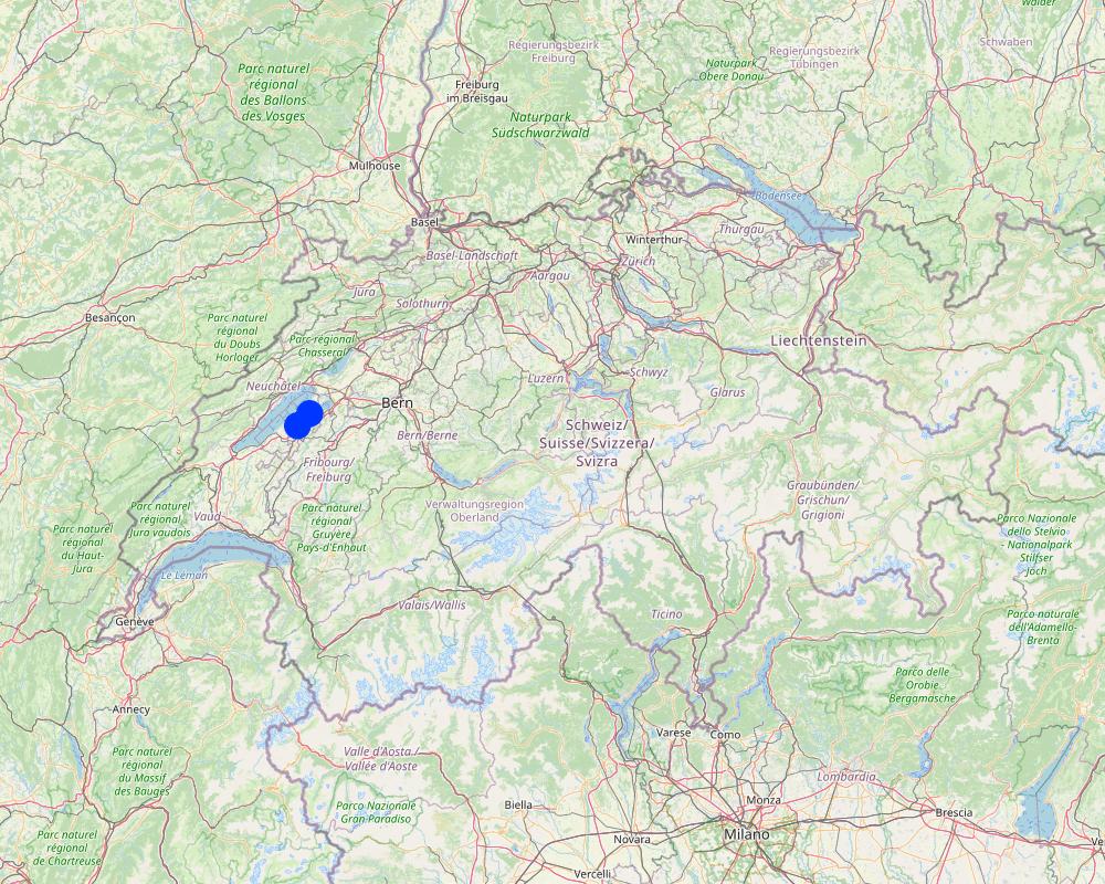
Country:
Switzerland
Region/ State/ Province:
FR/VD
Further specification of location:
Petite Glâne watershed, 4 communities: Vallon, Missy, St. Aubin, Vully-le-Lac
Specify the spread of the Technology:
- evenly spread over an area
If precise area is not known, indicate approximate area covered:
- 0.1-1 km2
Is/are the technology site(s) located in a permanently protected area?
Nee
Comments:
The average enlargement of the river will be 15 m and then 35 - 60 m of a riparian zone over a length of 7 km.
Map
×2.6 Date of implementation
Indicate year of implementation:
2022
2.7 Introduction of the Technology
Specify how the Technology was introduced:
- through projects/ external interventions
Comments (type of project, etc.):
The communities wanted to improve the current situation with respect to the threat of flooding through more extreme rain events, and for improving the biodiversity in the area.
3. Classification of the SLM Technology
3.1 Main purpose(s) of the Technology
- conserve ecosystem
- protect a watershed/ downstream areas – in combination with other Technologies
- preserve/ improve biodiversity
- reduce risk of disasters
- adapt to climate change/ extremes and its impacts
3.2 Current land use type(s) where the Technology is applied
Land use mixed within the same land unit:
Nee

Forest/ woodlands
- (Semi-)natural forests/ woodlands
- Tree plantation, afforestation
Tree plantation, afforestation: Specify origin and composition of species:
- Mixed varieties
Are the trees specified above deciduous or evergreen?
- deciduous
Products and services:
- Nature conservation/ protection
- Recreation/ tourism
- Protection against natural hazards

Waterways, waterbodies, wetlands
- Drainage lines, waterways
3.3 Has land use changed due to the implementation of the Technology?
Has land use changed due to the implementation of the Technology?
- Yes (Please fill out the questions below with regard to the land use before implementation of the Technology)
Land use mixed within the same land unit:
Nee

Cropland
- Annual cropping
Is crop rotation practiced?
Ja

Settlements, infrastructure
- Traffic: roads, railways
Remarks:
bridges, agricultural roads
Waterways, waterbodies, wetlands
- Swamps, wetlands
3.4 Water supply
Water supply for the land on which the Technology is applied:
- rainfed
3.5 SLM group to which the Technology belongs
- natural and semi-natural forest management
- surface water management (spring, river, lakes, sea)
- ecosystem-based disaster risk reduction
3.6 SLM measures comprising the Technology

vegetative measures
- V1: Tree and shrub cover

structural measures
- S2: Bunds, banks

management measures
- M1: Change of land use type
- M2: Change of management/ intensity level
3.7 Main types of land degradation addressed by the Technology

soil erosion by water
- Wr: riverbank erosion

biological degradation
- Bh: loss of habitats
- Bs: quality and species composition/ diversity decline

water degradation
- Hs: change in quantity of surface water
- Hp: decline of surface water quality
3.8 Prevention, reduction, or restoration of land degradation
Specify the goal of the Technology with regard to land degradation:
- prevent land degradation
- restore/ rehabilitate severely degraded land
4. Technical specifications, implementation activities, inputs, and costs
4.1 Technical drawing of the Technology
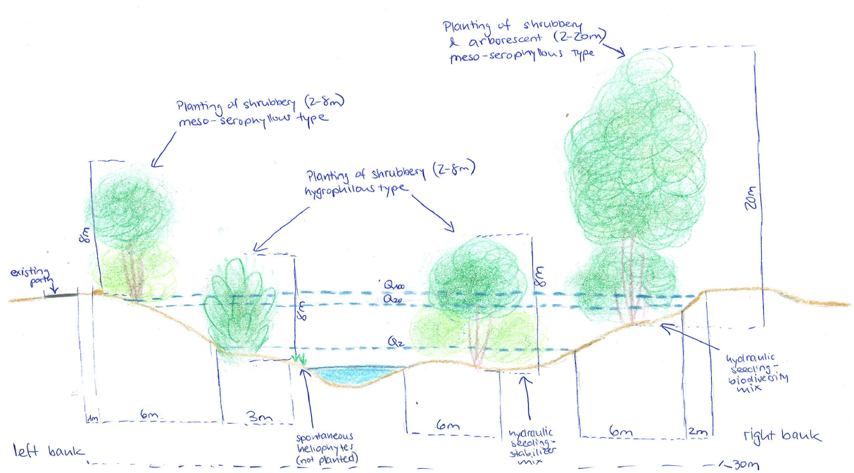
Technical specifications (related to technical drawing):
Between 2022 and 2026, the Petite Glâne is being revitalized on a length of 7 km with an average enlargement of the riparian zone of 15 m which totals in the riparian zone having a width between 35 and 60 m. 30,000 young trees and shrubs (from 37 species) and 100 larger trees are being planted. In addition, 200 small structures for wildlife will be provided. The very steep riverbanks are being reduced in their slope. Material used for the reconstruction of the river mainly comprises vegetation.
Author:
Nives Ramisberger
Date:
13/07/2022
4.2 General information regarding the calculation of inputs and costs
Specify how costs and inputs were calculated:
- per Technology area
Indicate size and area unit:
33 ha (medium width of riparian area ((35+60)/2) * length of river reach (7km))
other/ national currency (specify):
CHF
If relevant, indicate exchange rate from USD to local currency (e.g. 1 USD = 79.9 Brazilian Real): 1 USD =:
0.98
4.3 Establishment activities
| Activity | Timing (season) | |
|---|---|---|
| 1. | communication (with communities etc.) and looking for sponsoring | 2018 |
| 2. | completion of studies | 2018 |
| 3. | survey/planning/project execution | 2018 |
| 4. | Delays due to the Corona pandemic, start of reconstruction was originally planned for 2020 | |
| 5. | search for company | 2022 |
| 6. | implementation | 2022-2025 |
Comments:
This list is basically a list of the different steps that are involved in any project and show how long it took from first thinking about implementing the revitalization until now realizing. The implementation is not bound to any season and expected to be carried out continuously.
4.4 Costs and inputs needed for establishment
| Specify input | Unit | Quantity | Costs per Unit | Total costs per input | % of costs borne by land users | |
|---|---|---|---|---|---|---|
| Labour | engineers, purchase of land | 1.0 | 3000000.0 | 3000000.0 | ||
| Plant material | trees, small structures | 30000.0 | 100.0 | 3000000.0 | ||
| Construction material | terracing, bridges | 1.0 | 15000000.0 | 15000000.0 | ||
| Other | unexpected | 1.0 | 500000.0 | 500000.0 | ||
| Total costs for establishment of the Technology | 21500000.0 | |||||
| Total costs for establishment of the Technology in USD | 21938775.51 | |||||
If land user bore less than 100% of costs, indicate who covered the remaining costs:
80% are paid by the federal government, 20% by the adjacent municipalities and local sponsors.
Comments:
The total cost is known and a broad estimation possible of how much is used for what but it was not possible to break it down into more detail because it is a big project and many stakeholders involved.
4.5 Maintenance/ recurrent activities
| Activity | Timing/ frequency | |
|---|---|---|
| 1. | Checking riverbed | every 2-3 years |
| 2. | Mowing of grass | 1-2 per year |
| 3. | Cutting/ pruning of trees | every 5-10 years (usually around 30% of the area at once) |
| 4. | General maintenance period | 2025-2028 |
| 5. | Follow-up, control of revitalization effects | 2038 |
Comments:
Grass needs to be cut 1-2 times a year. The other maintenance activities are not required so frequently. The watercourse must be checked every 2-3 years and every 5-10 years the trees may have to be cut. When cutting the trees 1/3 of the area should be done at once but not more to not disturb wildlife too much and give it space to retreat to. None of these activities are bound to any particular season. During the first 3 years after the finalization of the project, maintenance work will be carried out (checking if everything is still okay, how the river behaves, if plants grow, etc.).
4.6 Costs and inputs needed for maintenance/ recurrent activities (per year)
Comments:
The project is not yet in a phase in which the costs for maintenance can be estimated because the implementation hasn't yet started and will not finish before 2025. Also, it depends on how much of the maintenance can be done by the farmers of the adjacent lands and how much will need to be done through community workers which would increase costs.
4.7 Most important factors affecting the costs
Describe the most determinate factors affecting the costs:
The most expensive feature of this project is the volume of earth that will be removed from the now steep riverbanks to widen the riverbed. The earth removed will directly be used again for small hills and what is not used directly in the riparian zone will be distributed on the agriculturally used fields next to the rivers. Also, there are several bridges that cross the Petite Glâne, and by enlarging the riverbed the bridges need to be rebuilt as well - which drives up the price greatly.
5. Natural and human environment
5.1 Climate
Annual rainfall
- < 250 mm
- 251-500 mm
- 501-750 mm
- 751-1,000 mm
- 1,001-1,500 mm
- 1,501-2,000 mm
- 2,001-3,000 mm
- 3,001-4,000 mm
- > 4,000 mm
Specify average annual rainfall (if known), in mm:
865.00
Indicate the name of the reference meteorological station considered:
Payerne
Agro-climatic zone
- sub-humid
- semi-arid
average maximum temperature 14.2°C, average minimum temperature 5.1°C
5.2 Topography
Slopes on average:
- flat (0-2%)
- gentle (3-5%)
- moderate (6-10%)
- rolling (11-15%)
- hilly (16-30%)
- steep (31-60%)
- very steep (>60%)
Landforms:
- plateau/plains
- ridges
- mountain slopes
- hill slopes
- footslopes
- valley floors
Altitudinal zone:
- 0-100 m a.s.l.
- 101-500 m a.s.l.
- 501-1,000 m a.s.l.
- 1,001-1,500 m a.s.l.
- 1,501-2,000 m a.s.l.
- 2,001-2,500 m a.s.l.
- 2,501-3,000 m a.s.l.
- 3,001-4,000 m a.s.l.
- > 4,000 m a.s.l.
Indicate if the Technology is specifically applied in:
- concave situations
5.3 Soils
Soil depth on average:
- very shallow (0-20 cm)
- shallow (21-50 cm)
- moderately deep (51-80 cm)
- deep (81-120 cm)
- very deep (> 120 cm)
Soil texture (topsoil):
- medium (loamy, silty)
Soil texture (> 20 cm below surface):
- medium (loamy, silty)
Topsoil organic matter:
- medium (1-3%)
5.4 Water availability and quality
Ground water table:
5-50 m
Availability of surface water:
good
Water quality (untreated):
for agricultural use only (irrigation)
Water quality refers to:
surface water
Is water salinity a problem?
Nee
Is flooding of the area occurring?
Ja
Regularity:
episodically
Comments and further specifications on water quality and quantity:
The increasing threat of heavy rainfall events due to climate change enhances the threat of flooding which is why the revitalization is being implemented. Through enlargement of the riverbed and increasing surface roughness through vegetation, flooding of adjacent agricultural areas is expected to be less frequent. The effect of the plants directly on water quality/quantity are expected to be minor.
5.5 Biodiversity
Species diversity:
- low
Habitat diversity:
- low
Comments and further specifications on biodiversity:
Both are between low and medium, but low rather than medium.
5.6 Characteristics of land users applying the Technology
Sedentary or nomadic:
- Sedentary
Market orientation of production system:
- commercial/ market
Off-farm income:
- less than 10% of all income
Relative level of wealth:
- average
Individuals or groups:
- groups/ community
- employee (company, government)
Level of mechanization:
- mechanized/ motorized
Gender:
- women
- men
Age of land users:
- middle-aged
Indicate other relevant characteristics of the land users:
The land users now are farmers that rent or own the land. For implementing the technology the lease agreement was terminated and the land up to now owned by the farmers has been bought by the communities.
5.7 Average area of land used by land users applying the Technology
- < 0.5 ha
- 0.5-1 ha
- 1-2 ha
- 2-5 ha
- 5-15 ha
- 15-50 ha
- 50-100 ha
- 100-500 ha
- 500-1,000 ha
- 1,000-10,000 ha
- > 10,000 ha
Is this considered small-, medium- or large-scale (referring to local context)?
- medium-scale
Comments:
The technology is applied by communities
5.8 Land ownership, land use rights, and water use rights
Land ownership:
- communal/ village
- individual, titled
Land use rights:
- communal (organized)
Water use rights:
- communal (organized)
Are land use rights based on a traditional legal system?
Ja
Specify:
lease agreement
Comments:
Where possible farmers got other areas to substitute for that lost by implementing the revitalization
5.9 Access to services and infrastructure
health:
- poor
- moderate
- good
education:
- poor
- moderate
- good
technical assistance:
- poor
- moderate
- good
employment (e.g. off-farm):
- poor
- moderate
- good
markets:
- poor
- moderate
- good
energy:
- poor
- moderate
- good
roads and transport:
- poor
- moderate
- good
drinking water and sanitation:
- poor
- moderate
- good
financial services:
- poor
- moderate
- good
6. Impacts and concluding statements
6.1 On-site impacts the Technology has shown
Socio-economic impacts
Production
crop production
wood production
production area
Water availability and quality
irrigation water availability
irrigation water quality
Income and costs
farm income
Comments/ specify:
In the short term it is expected to decrease due to loss of land, in the long term not because of more resilience towards floods
diversity of income sources
Comments/ specify:
State subsidies for biodiversity areas
Socio-cultural impacts
land use/ water rights
cultural opportunities
recreational opportunities
Comments/ specify:
The landscape becomes more beautiful and new places to stay are made, but on the other hand many places are deliberately made inaccessible for the protection of flora & fauna.
conflict mitigation
Comments/ specify:
Simultaneously, the threat of flooding for farmers is decreased and enhancement of habitat created which is expected to lead to improved acceptance by all stakeholders
Ecological impacts
Water cycle/ runoff
water quantity
water quality
harvesting/ collection of water
surface runoff
Comments/ specify:
Will be slightly improved through reducing the gradient of riverbanks
excess water drainage
groundwater table/ aquifer
evaporation
Comments/ specify:
Less evaporation but more evapotranspiration expected
Soil
soil moisture
soil cover
soil loss
Biodiversity: vegetation, animals
Vegetation cover
biomass/ above ground C
plant diversity
invasive alien species
animal diversity
beneficial species
habitat diversity
Climate and disaster risk reduction
flood impacts
drought impacts
Comments/ specify:
It is not known yet if there will be any difference for after the implementation but it is expected that the difference will be negligible
impacts of cyclones, rain storms
emission of carbon and greenhouse gases
wind velocity
micro-climate
Specify assessment of on-site impacts (measurements):
Observations, measurements and projections
6.2 Off-site impacts the Technology has shown
water availability
reliable and stable stream flows in dry season
downstream flooding
downstream siltation
groundwater/ river pollution
buffering/ filtering capacity
wind transported sediments
damage on neighbours' fields
damage on public/ private infrastructure
Specify assessment of off-site impacts (measurements):
Observations, measurements and projections
6.3 Exposure and sensitivity of the Technology to gradual climate change and climate-related extremes/ disasters (as perceived by land users)
Gradual climate change
Gradual climate change
| Season | increase or decrease | How does the Technology cope with it? | |
|---|---|---|---|
| annual temperature | increase | moderately |
Climate-related extremes (disasters)
Meteorological disasters
| How does the Technology cope with it? | |
|---|---|
| local thunderstorm | well |
| local hailstorm | moderately |
Climatological disasters
| How does the Technology cope with it? | |
|---|---|
| heatwave | moderately |
| drought | moderately |
Hydrological disasters
| How does the Technology cope with it? | |
|---|---|
| general (river) flood | very well |
| flash flood | very well |
6.4 Cost-benefit analysis
How do the benefits compare with the establishment costs (from land users’ perspective)?
Short-term returns:
positive
Long-term returns:
positive
How do the benefits compare with the maintenance/ recurrent costs (from land users' perspective)?
Short-term returns:
positive
Long-term returns:
positive
Comments:
The short term benefits (1-3 years after implementation) are considered positive as the technology shows positive effects on ecosystem services (e.g. flood protection) within a short period of time despite the high establishment costs.
6.5 Adoption of the Technology
- single cases/ experimental
Comments:
The communities were initiating the revitalization and did not do so before finding sponsors and subventions
6.6 Adaptation
Has the Technology been modified recently to adapt to changing conditions?
Nee
6.7 Strengths/ advantages/ opportunities of the Technology
| Strengths/ advantages/ opportunities in the land user’s view |
|---|
| Less flooding |
| Small improvement in soil quality |
| Strengths/ advantages/ opportunities in the compiler’s or other key resource person’s view |
|---|
| Biodiversity |
| Positive measure against warming waters |
| Improvement of the landscape and therefore of the quality for recreational purposes |
| Flood protection |
6.8 Weaknesses/ disadvantages/ risks of the Technology and ways of overcoming them
| Weaknesses/ disadvantages/ risks in the land user’s view | How can they be overcome? |
|---|---|
| Loss of agricultural land |
Exchange of plots (next to river taken; elsewhere, another given) Financial compensation |
| Weaknesses/ disadvantages/ risks in the compiler’s or other key resource person’s view | How can they be overcome? |
|---|---|
| High costs | Sponsoring/subsidies needed |
7. References and links
7.1 Methods/ sources of information
- field visits, field surveys
Visit with specialists
- interviews with SLM specialists/ experts
2 key persons > engineers from different companies
When were the data compiled (in the field)?
13/07/2022
7.4 General comments
The municipality owns the land that is now used by the farmers. To make up for the lost land the municipality provided other plots for them to use. Nevertheless, the total loss of agricultural land amounts to 11 ha.
Links and modules
Expand all Collapse allLinks
No links
Modules
No modules