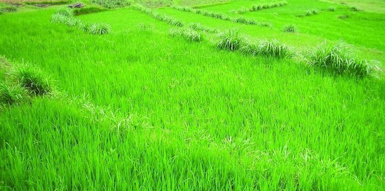
Overview of improved terraces with soil and water conservation (SWC) grasses on riser margins. Maize was the major crop before the terraces were improved. Now vegetables and rice are grown. (K.M. Sthapit)

Improved terraces (النيبال)

GARA SUDHAR- Nepali

الوصف

Hillside forward-sloping terracing and stabilisation using structural and vegetative measures

This technology addresses the soil erosion and water runoff problems associated with traditional outward-sloping terraces by reshaping the land into a series of level or gently sloping platforms across the slope. This technology is a variant of sloping land agricultural technology (SALT) or contour hedgerow technology. Nitrogen-fixing hedgerow species and quality fodder grass species, which bind the soil, are cultivated along terrace riser margins to improve terrace stability. This also enhances soil fertility and increases fodder availability. The plants are grown in either single or multiple layers. The practice is applied under rainfed conditions and is culturally acceptable and affordable. After establishment, the technology also addresses the problems of fodder scarcity making it easier and less time consuming for women and girls to gather fodder.
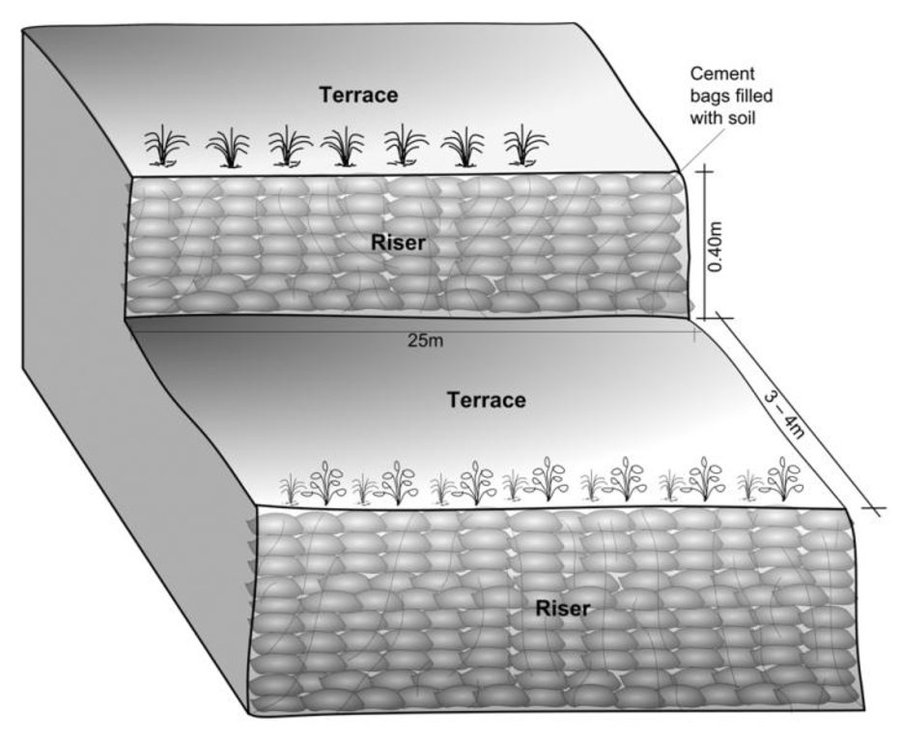
The hedgerow and grass species are established between January and June. Complete establishment of this technology may take one year. The first step in creating the terraces is to build retaining walls using cement bags filled with soil which are then supported with bamboo cuttings along the contour (= future terrace risers). This divides the land into the planned terrace sections. The length and width of the terraces depends on the size and shape of the original field. Secondly, the soil is excavated from the upper part of the terraces and is used to build up the lower part above and behind the terrace riser wall to create a level bed. The fertile top soil must be kept aside and later spread over the newly terraced fields. The final step is to plant grass and hedgerow species on the outermost margins of the terrace above the risers.
Maintenance involves slicing the terrace risers once or twice a year with a spade, and smoothing off rills that appear on the surface of terraces after the premonsoon and monsoon periods. Hedgerows should be cut regularly but not more than twice a year, normally to a height of about 50 cm. Grasses should be cut about once to twice a month depending on their rate of growth.
The technology is applied under humid subtropical climate conditions (1300 mm annual rainfall with about 80% of it falling in the monsoon months of June - September). The case study area has hill slopes of 16-30% that are mostly highly erodible red soils (FAO classification: luvisols).

الموقع

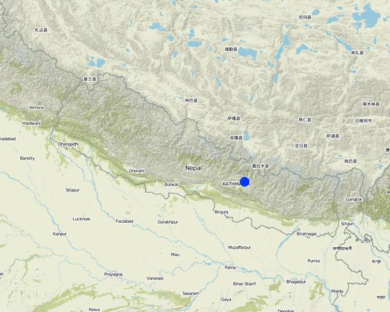
الموقع: Hokse VDC ward no2, النيبال

عدد مواقع تنفيذ التقنيةالتي تم تحليلها:

المرجع الجغرافي للمواقع المختارة
  • 85.52133, 27.75651

انتشار التقنية: منتشرة بالتساوي على مساحة (0.0126 km²)

في منطقة محمية بشكل دائم؟:

تاريخ التنفيذ: منذ أكثر من 50 عامًا (تقليدي)

نوع التقديم

تصنيف التقنية

الغرض الرئيسي
  • تحسين الإنتاج
  • الحد من تدهور الأراضي ومنعه وعكسه
  • الحفاظ على النظام البيئي
  • حماية مستجمعات المياه / المناطق الواقعة في اتجاه مجرى النهر - مع تقنيات أخرى
  • الحفاظ على/تحسين التنوع البيولوجي
  • الحد من مخاطر الكوارث
  • التكيف مع تغير المناخ/الظواهر المتطرفة وآثارها
  • التخفيف من تغير المناخ وآثاره
  • خلق أثر اقتصادي مفيد
  • خلق أثر اجتماعي مفيد
استخدام الأراضي

  • الأراضي الزراعية
    • زراعة سنوية: الحبوب - الذرة, الحبوب البقولية والبقول- الفاصوليا, المحاصيل الجذرية/الدرنية - البطاطس, wheat, chili, tomatoes
    عدد مواسم الزراعة في السنة: 3
إمدادات المياه
  • بعلية
  • مختلط بعلي-مروي
  • ري كامل

الغرض المتعلق بتدهور الأراضي
  • منع تدهور الأراضي
  • الحد من تدهور الأراضي
  • اصلاح/إعادة تأهيل الأراضي المتدهورة بشدة
  • التكيف مع تدهور الأراضي
  • غير قابل للتطبيق
معالجة التدهور
  • تآكل التربة بالمياه - الوزن(Wt): فقدان التربة السطحية/تآكل السطح, (Wg):الانجراف الخلجاني/ الخلجان
  • تدهور المياه - (Ha): التجفيف
مجموعة الإدارة المستدامة للاراضي
  • التدابير المتقاطعة للمنحدرات
  • تحويل المياه والصرف
تدابير الإدارة المستدامة للأراضي
  • التدابير النباتية - V1: غطاء من الأشجار والشجيرات
  • التدابير البنيوية - S1: المصاطب المتدرجة

الرسم الفني

المواصفات الفنية
Schematric view after intervention [terracing and vegetative measures]
Riser slope: 75 degree
Terrace slope: ~ 2 degree

Location: Kubinde

Technical knowledge required for field staff / advisors: high

Technical knowledge required for land users: moderate

Main technical functions: control of concentrated runoff: impede / retard, reduction of slope angle, reduction of slope length

Secondary technical functions: increase of infiltration, increase / maintain water stored in soil, increase in soil fertility

Vegetative measure: on risers
Vegetative material: T : trees / shrubs, G : grass
Number of plants per (ha): 2500
Vertical interval between rows / strips / blocks (m): 1.5
Spacing between rows / strips / blocks (m): 3 to 4
Vertical interval within rows / strips / blocks (m): 0.25

Vegetative measure: Vegetative material: T : trees / shrubs, G : grass

Vegetative measure: Vegetative material: T : trees / shrubs, G : grass

Vegetative measure: Vegetative material: T : trees / shrubs, G : grass

Trees/ shrubs species: Sunhemp(Crotalaria juncea),Tephrosia (Tephrosia candida) and Flemingia (Flemingia microphylla)

Grass species: Napier(Pennisetum purpureum),Molasses (Melinis minutiflora) and Stylo(Stylosanthes guianensis)

Slope (which determines the spacing indicated above): 5.00%

If the original slope has changed as a result of the Technology, the slope today is (see figure below): 5.00%

Gradient along the rows / strips: 75.00%

Terrace: bench level
Vertical interval between structures (m): 1.5
Width of ditches/pits/dams (m): 3-4
Length of ditches/pits/dams (m): 10-15

Construction material (earth): Cement bag filled with soil, Bamboo nets were used to make risers.

Slope (which determines the spacing indicated above): 30%

If the original slope has changed as a result of the Technology, the slope today is: 5%

Vegetation is used for stabilisation of structures.
Author: Madhav Dhakal, A. K. Thaku

التأسيس والصيانة: الأنشطة والمدخلات والتكاليف

حساب المدخلات والتكاليف
  • يتم حساب التكاليف:
  • العملة المستخدمة لحساب التكلفة: دولار أمريكي USD
  • سعر الصرف (بالدولار الأمريكي): 1 دولار أمريكي = -1.0
  • متوسط تكلفة أجر العمالة المستأجرة في اليوم: 1.40
أهم العوامل المؤثرة على التكاليف
In case of projects interested in promoting this technology in the region, the labour cost is the major expenditure in the initial stage.The labour charges are decided by the district soil conservation office.
أنشطة التأسيس
  1. Area estimation ( for vegetative measures) (التوقيت/الوتيرة: before rainy seasonn/lean period (February))
  2. Selection of fodder grass species (التوقيت/الوتيرة: Before rainy season (Feb))
  3. Planting of grasses and hedgerow species on the outward margins (التوقيت/الوتيرة: During rainy season.)
  4. Establishment of riser, using cement bags (filled with soil) and bamboo culms for terrace stabilisation (التوقيت/الوتيرة: Beginning of rainy season(May))
  5. Terrace leveling:The length and width of the terraces depends on the size and shape of the field. Excavate soil from the upper part of the terrace field and use it to build up the lower part behind the terrace riser wallt creat a level plateform/bed. (التوقيت/الوتيرة: Beginning of rainy season(May))
مدخلات وتكاليف التأسيس
تحديد المدخلات الوحدة الكمية التكاليف لكل وحدة (دولار أمريكي USD) إجمالي التكاليف لكل مدخل (دولار أمريكي USD) % من التكاليف التي يتحملها مستخدمو الأراضي
العمالة
Labour ha 1,0 970,0 970,0 50,0
معدات
Total costs ha 1,0 92,0 92,0 100,0
المواد النباتية
Seeds ha 1,0 25,0 25,0
Seedlings ha 1,0 30,0 30,0
Bamboo culms 80,0 1,0 80,0 50,0
مواد البناء
Cement bags ha 1,0 80,0 80,0 50,0
غير ذلك
Supervision charge ha 1,0 10,5 10,5
إجمالي تكاليف إنشاء التقنية 1'287.5
إجمالي تكاليف إنشاء التقنية بالدولار الأمريكي -1'287.5
أنشطة الصيانة
  1. Hedgerow/grass maintenance: Hedgerows are cut regularly but not (التوقيت/الوتيرة: Grass is cut once or twice a month.)
  2. (Re)plantation of hedge species if necessary (التوقيت/الوتيرة: Before monsoon /1*/year)
  3. Surface and riser maintenance: smooth the surface/rills on the (التوقيت/الوتيرة: after pre monsoon and after monsoon/2 */ year ,Jun)
مدخلات وتكاليف الصيانة
تحديد المدخلات الوحدة الكمية التكاليف لكل وحدة (دولار أمريكي USD) إجمالي التكاليف لكل مدخل (دولار أمريكي USD) % من التكاليف التي يتحملها مستخدمو الأراضي
العمالة
Labour ha 1,0 310,0 310,0 100,0
معدات
Tools total costs ha 1,0 20,0 20,0 100,0
المواد النباتية
Seeds ha 1,0 6,0 6,0 100,0
Seedlings ha 1,0 6,0 6,0 100,0
إجمالي تكاليف صيانة التقنية 342.0
إجمالي تكاليف صيانة التقنية بالدولار الأمريكي -342.0

المناخ الطبيعي

متوسط هطول الأمطار السنوي
  • < 250 مم
  • 251- 500 ملم
  • 501 - 750ملم
  • 1,000-751 ملم
  • 1,500-1,100 ملم
  • 2,000-1,500 ملم
  • 3,000-2,001 ملم
  • 4,000-3,100 ملم
  • > 4000 ملم
المنطقة المناخية الزراعية
  • رطبة
  • شبه رطبة
  • شبه قاحلة
  • قاحلة
المواصفات الخاصة بالمناخ
متوسط هطول الأمطار السنوي بالملليمتر: 1304.0
Thermal climate class: subtropics
المنحدر
  • مسطح (0-2%)
  • بسيط (3-5%)
  • معتدل (6-10%)
  • متدحرج (11-15%)
  • تلال (16-30%)
  • شديدة الانحدار(31-60%)
  • فائقة الانحدار (>60%)
التضاريس
  • هضاب/سهول
  • أثلام مرتفعة
  • المنحدرات الجبلية
  • منحدرات التلال
  • منحدرات في السفوح
  • قاع الوادي
الارتفاع
  • 100-0 متر فوق سطح البحر
  • 500-101 متر فوق سطح البحر
  • 1,000-501 متر فوق سطح البحر
  • 1,500-1,001 متر فوق سطح البحر
  • 2,000-1,501 متر فوق سطح البحر
  • 2,500-2,100 متر فوق سطح البحر
  • 3,000-2,501 متر فوق سطح البحر
  • 4,000-3,001 متر فوق سطح البحر
  • > 4000 متر فوق سطح البحر
يتم تطبيق التقنية في
  • حالات محدبة أو نتؤات
  • حالات مقعرة
  • غير ذات صلة
عمق التربة
  • ضحل جدًا (0-20 سم)
  • ضحلة (21-50 سم)
  • متوسطة العمق (51-80 سم)
  • عميقة (81-120 سم)
  • عميقة جدًا (> 120 سم)
قوام التربة (التربة السطحية)
  • خشن / خفيف (رملي)
  • متوسط ( طميي، سلتي)
  • ناعم/ثقيل (طيني)
قوام التربة (> 20 سم تحت السطح)
  • خشن / خفيف (رملي)
  • متوسط ( طميي، سلتي)
  • ناعم/ثقيل (طيني)
محتوى المادة العضوية في التربة السطحية
  • عالية (>3%)
  • متوسطة (1-3%)
  • منخفضة (<1%)
مستوى المياه الجوفية
  • سطحية
  • < 5 م
  • 50-5 م
  • > 50 م
توافر المياه السطحية
  • زائدة
  • جيد
  • متوسط
  • ضعيف/ غير متوافر
جودة المياه (غير المعالجة)
  • مياه شرب جيدة
  • مياه الشرب سيئة (تتطلب معالجة)
  • للاستخدام الزراعي فقط (الري)
  • غير صالحة للإستعمال
تشير جودة المياه إلى:
هل تمثل الملوحة مشكلة؟
  • نعم
  • كلا

حدوث الفيضانات
  • نعم
  • كلا
تنوع الأنواع
  • مرتفع
  • متوسط
  • منخفض
تنوع الموائل
  • مرتفع
  • متوسط
  • منخفض

خصائص مستخدمي الأراضي الذين يطبقون التقنية

التوجه السوقي
  • الكفاف (الإمداد الذاتي)
  • مختلط (كفاف/ تجاري)
  • تجاري/سوق
الدخل من خارج المزرعة
  • أقل من % 10من كامل الدخل
  • 10-50% من جميع الإيرادات
  • ‏‏ >50‏% من إجمالي الدخل
المستوى النسبي للثروة
  • ضعيف جدا
  • ضعيف
  • متوسط
  • ثري
  • ثري جدا
مستوى المكننة
  • عمل يدوي
  • الجر الحيواني
  • ميكانيكية/ مزودة بمحرك
مستقر أو مرتحل
  • غير المترحل
  • شبه مرتحل
  • مرتحل
أفراد أو مجموعات
  • فرد/أسرة معيشية
  • المجموعات/ المجتمع المحلي
  • تعاونية
  • موظف (شركة، حكومة)
الجنس
  • نساء
  • رجال
العمر
  • أطفال
  • شباب
  • متوسط العمر
  • كبار السن
المساحة المستخدمة لكل أسرة
  • < 0.5 هكتارا
  • 0.5 - 1 هكتار
  • 1 -2 هكتار
  • 2 - 5 هكتار
  • 5 - 15 هكتار
  • 15 - 50 هكتار
  • 50 - 100هكتار
  • 500-100 هكتار
  • 1,000-500 هكتار
  • 10,000-1,000 هكتار
  • > 10,000 هكتار
الحجم
  • على نطاق صغير
  • على نطاق متوسط
  • على نطاق واسع
ملكية الارض
  • دولة
  • شركة
  • مجتمعي/قروي
  • لمجموعة
  • فردية، لا يوجد سند ملكية
  • فردية، يوجد سند ملكية
حقوق استخدام الأراضي
  • وصول مفتوح (غير منظم)
  • مجتمعي (منظم)
  • مؤجر
  • فردي
حقوق استخدام المياه
  • وصول مفتوح (غير منظم)
  • مجتمعي (منظم)
  • مؤجر
  • فردي
الوصول إلى الخدمات والبنية التحتية

الآثار

الآثار الاجتماعية والاقتصادية
إنتاج المحاصيل
انخفض
x
زاد


maize crop by 100%

إنتاج الأعلاف
انخفض
x
زاد


households of neighbouring village benefitted.

جودة العلف
انخفض
x
زاد

منطقة الإنتاج (الأراضي الجديدة المزروعة/المستخدمة)
انخفض
x
زاد

دخل المزرعة
انخفض
x
زاد


by >100% due to higher

الآثار الاجتماعية والثقافية
المؤسسات المجتمعية
أضعفت
x
تعزز


terrace improvement group was formed

Livelihood and human well-being
reduced
x
improved


Cropping pattern changed due to which, land users were able to produce more. Farm income and price of land increased.

الآثار الايكولوجية
رطوبة التربة
انخفض
x
زاد


nearby hedgerows

غطاء التربة
انخفاض
x
تحسن


along risers

فقدان التربة
زاد
x
انخفض


due to levelled surface and hedgerow barrier

Appearance of pests like rats due to introduction of planted
decreased
x
increased

الآثار خارج الموقع
الفيضانات في اتجاه مجرى النهر (غير مرغوب فيها)
زاد
x
انخفاض


Bigger area needs swc measures

تراكم الطمي باتجاه مصب النهر
زاد
x
انخفض

Fodder grass seed distribution
decreased
x
increased


through farmer to farmer dissemination

Nutrients downstream
decreased
x
increased


due to reduced nutrients leaching on-site

تحليل التكلفة والعائد

العوائد مقارنة بتكاليف التأسيس
عوائد قصيرة الأجل
سلبي للغاية
x
ايجابي جدا

عوائد طويلة الأجل
سلبي للغاية
x
ايجابي جدا

العوائد مقارنة بتكاليف الصيانة
عوائد قصيرة الأجل
سلبي للغاية
x
ايجابي جدا

عوائد طويلة الأجل
سلبي للغاية
x
ايجابي جدا

The initial investment is high, but can be recovered within a short period due to yield increment and cash crop production.

تغير المناخ

تغير مناخ تدريجي
درجة الحرارة السنوية زيادة

ليس جيدا على الاطلاق
x
جيدة جدا
الظواهر المتطرفة / الكوارث المرتبطة بالمناخ
عاصفة ممطرة محلية

ليس جيدا على الاطلاق
x
جيدة جدا
عاصفة هوائية محلية

ليس جيدا على الاطلاق
x
جيدة جدا
جفاف

ليس جيدا على الاطلاق
x
جيدة جدا
فيضان عام (نهر)

ليس جيدا على الاطلاق
x
جيدة جدا
العواقب الأخرى المتعلقة بالمناخ
انخفاض فترة النمو

ليس جيدا على الاطلاق
x
جيدة جدا

التبني والتكيف

نسبة مستخدمي الأراضي في المنطقة الذين تبنوا التقنية
  • حالات فردية/تجريبية
  • 1-10‏%
  • 11-50%
  • > 50%
من بين جميع الذين تبنوا التقنية، كم منهم فعلوا ذلك دون تلقي أي حوافز مادية؟
  • 10-0‏%
  • 11-50%
  • 51-90%
  • 91-100%
عدد الأسر المعيشية و/أو المساحة المغطاة
16 households in an area of 0.0126 sq km
هل تم تعديل التقنية مؤخرًا لتتكيف مع الظروف المتغيرة؟
  • نعم
  • كلا
مع أي من الظروف المتغيرة؟
  • تغير المناخ / التطرف
  • الأسواق المتغيرة
  • توفر العمالة (على سبيل المثال بسبب الهجرة)

الاستنتاجات والدروس المستفادة

نقاط القوة: وجهة نظر مستخدم الأرض
  • The price of land increased considerably from NRs 30,000 in 2001 (for 1 ropani – 508.5 sq. m) to between NRs 100, 000 and NRs 150,000 per ropani after the technology was established

    How can they be sustained / enhanced? The price would increase further if irrigation facilities were installed
  • Pedicels of Tephosia and Sunhemp can be used for firewood.
  • Instead of planting only maize a farmer started planting rice (primary crop) and cash crops like potato / tomato (secondary crops).
نقاط القوة: وجهة نظر جامع المعلومات أو غيره من الأشخاص الرئيسيين لمصدر المعلومات
  • The area of levelled terraces nearly doubled in Kubinde village from 2001 to 2003, which is an indicator of increased awareness of the benefi ts of soil and water conservation.

    How can they be sustained / enhanced? Experience sharing would help expand the area
    under improved terraces.
  • Land productivity increased, maize, potato and bean production increased, vegetables and rice production started.

    How can they be sustained / enhanced? Irrigation facility could increase the production capacity of the terraces.
  • Availability of grass/fodder (nitrogen fixing) increased.

    How can they be sustained / enhanced? Planting horticultural
    fruits could increase farm incomes and so it should be promoted and more nitrogen fi xing species (preferably local) should be tried out
نقاط الضعف / المساوىء / المخاطر: وجهة نظر مستخدم الأرضكيفية التغلب عليها
  • In the fi rst year of implementation, maize production was reduced due to soil amendment a phenomenon which is likely to occur with new
    terrace formation
نقاط الضعف / المساوىء / المخاطر: وجهة نظر جامع المعلومات أو غيره من الأشخاص الرئيسيين لمصدر المعلوماتكيفية التغلب عليها
  • Presently the vegetative technology is confined to terrace margins it should be extended to the risers also.

المراجع

جامع المعلومات
  • Madhav Dhakal
المحررون
المُراجع
  • David Streiff
  • Alexandra Gavilano
تاريخ التوثيق: 7 يونيو، 2011
اخر تحديث: 5 سبتمبر، 2019
الأشخاص الرئيسيين لمصدر المعلومات
الوصف الكامل في قاعدة بيانات WOCAT
بيانات الإدارة المستدامة للأراضي المرتبطة
تم تسهيل التوثيق من قِبَل
المؤسسة المشروع
المراجع الرئيسية
  • ICIMOD (2002) Hydro-meteorological Year Book of Jhikhu Khola Watershed. Kathmandu: ICIMOD: ICIMOD
  • Mathema, P.; Singh, B.K. (2003) Soil ErosionStudies in Nepal: Results and Implications. Kathmandu: Government of Nepal, Department of Soil Conservation and Watershed Management:
  • Mathema, P. (2003) Watershed Managementin South Asia. Kathmandu: Government of Nepal, Department of Soil Conservation and Watershed Management:
This work is licensed under Creative Commons Attribution-NonCommercial-ShareaAlike 4.0 International