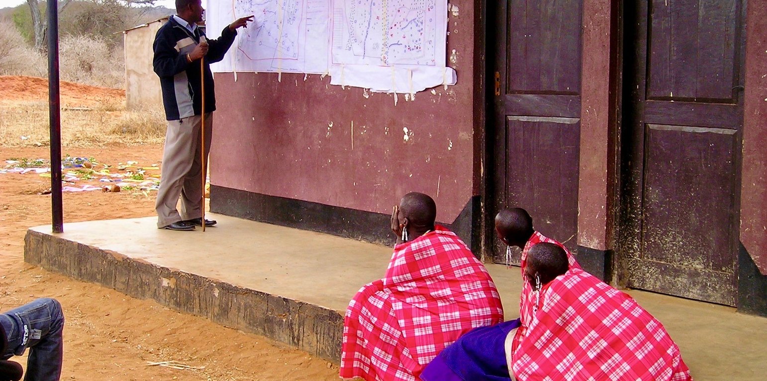
Participatory mapping of shared resources is the first step in the joint village land use planning approach. (Fiona Flintan)

Joint village land use planning (تنزانيا، جمهورية تنزانيا المتحدة)

الوصف

Joint village land use planning is a process facilitated by Tanzania's land policy and legislation. It supports the planning, protection and management of shared resources across village boundaries. It is an important tool towards land use planning and better rangeland management. This case study provides an example from a cluster of villages in Kiteto District, Tanzania.

The Sustainable Rangeland Management Project (SRMP) is an initiative led by Tanzania’s Ministry of Livestock and Fisheries (MoLF), the International Livestock Research Institute (ILRI) and the National Land Use Planning Commission (NLUPC), with support from International Fund for Agricultural Development (IFAD), Irish Aid and the International Land Coalition (ILC). A key innovation of the project has been the development of joint village land use planning (JVLUP). The JVLUP process in Kiteto District, Manyara Region began in November 2013, and included the villages of Lerug, Ngapapa, and Orkitikiti. The three villages share boundaries and grazing resources, and in order to illustrate a single shared identity across the boundaries, the name OLENGAPA was chosen - incorporating part of each village’s name.
The total area of the three villages is (approx.) 59,000 hectares. The majority of inhabitants are Maasai pastoralists with some Ndorobo hunter-gatherers, and some farmers - most of whom are seasonal migrants. Mobility is central to the survival of the pastoralists and takes place across the three villages, as well as to locations in Kilindi, Gairo, and Bagamoyo Districts.
Average annual rainfall is between 800-1,000 mm per annum. There are no perennial rivers flowing through the OLENGAPA villages. The only permanent surface water source is Orkitikiti Dam, constructed in 1954.
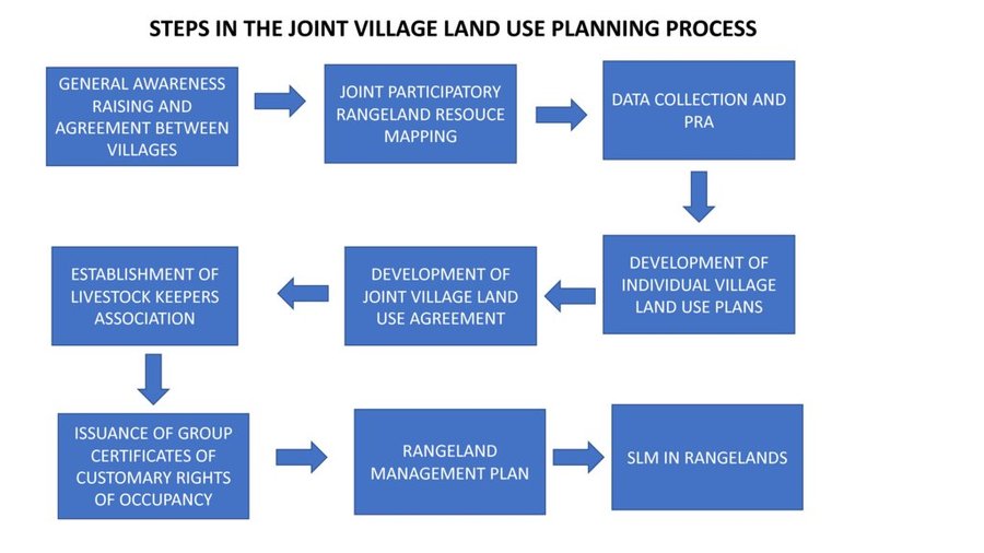
In order to understand the different resources such as grazing areas, water points, cropping areas, livestock routes, and cultural places, SRMP supported participatory mapping. This assisted in developing a base map for the village land use planning process: it showed which resources were shared by the villages and where they were situated.
SRMP then helped village members to agree the individual village land use maps and plans - which zoned the village land into priority land uses - as well as the joint village land use map and plan, and the joint village land use agreement (JVLUA). These specified the grazing areas, water points, livestock routes and other shared resources. Reaching agreement was a protracted negotiation process between the villages, and within villages also - between different interest groups. It involved numerous community meetings and considerable investment of resources. Finally, each Village Assembly approved the JVLUA, which allocated approx. 20,700 ha of land for shared grazing –around 40% of the total village area. By-laws for management of the resources were developed and adopted.
Following approval of the JVLUA, the three OLENGAPA Village Councils established a Joint Grazing Land Committee made up of members from all three villages. This Committee is responsible for planning, management, enforcement of by-laws applicable to the OLENGAPA, and coordination of the implementation of both the OLENGAPA land use agreements and joint land use plan. In addition, a Livestock Keepers Association was established, including 53 founding members – but with most households from the three villages being associate members. A constitution was developed for the Association, which was officially registered on 11 September 2015.
In January 2016 the Ministry of Lands approved and registered the village land boundary maps and deed plans for the three villages. The District Council has issued the village land certificates, and the next step is for Village Councils to begin issuing Certificates of Customary Rights of Occupancy (CCROs). The shared grazing area will require three group CCROs to be issued to the Livestock Keepers Association – one from each village - for the part of the grazing area that falls under its jurisdiction. Signboards and beacons marking the shared grazing area are being put in place.
In November 2017 a fourth village joined OLENGAPA, expanding the shared grazing area to 30,000 ha. The villages are now working to develop a management plan to improve rangeland productivity.
الموقع

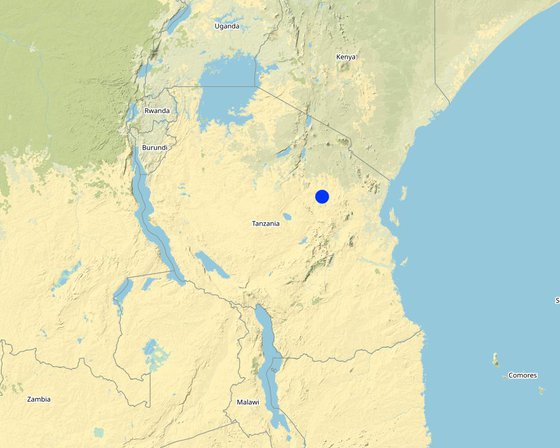
الموقع: Kiteto District, Manyara Region, تنزانيا، جمهورية تنزانيا المتحدة

المرجع الجغرافي للمواقع المختارة
  • 36.5366, -5.31046

تاريخ البدء: 2010

سنة الإنهاء: 2017

نوع النهج
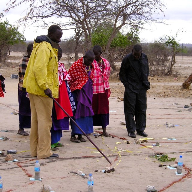
Rangeland resources mapping is an important step in the joint village land use planning process (Fiona Flintan)
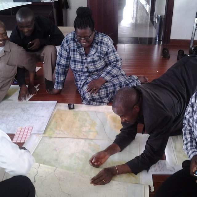
Mapping livestock routes contributed to an understanding of mobility patterns across regions and villages (Mohammed Said)

غايات النهج والبيئة المواتية

الغايات/الأهداف الرئيسية للنهج
To secure shared grazing areas and other rangeland resources for livestock keepers, and to improve their management.
الشروط التي تمكن من تنفيذ التقنية/التقنيات المطبقة في إطار النهج
  • المعايير والقيم الاجتماعية /الثقافية/ الدينية: History of collective tenure, management and sharing of rangeland resources as part of sustainable rangeland management practices.
  • الإطار المؤسساتي: Strong local government/community institutions for leading process at local albeit their capacity may require building.
  • الإطار القانوني (حيازة الأراضي، وحقوق استخدام الأراضي والمياه): Tanzania's legislation, if implemented well, provides an enabling environment for securing of community/village rights for both individuals and groups.
  • السياسات: Tanzania possesses facilitating national land use policy for the joint village land use planning approach, together with guidelines.
  • حوكمة الأراضي (صنع القرار والتنفيذ والإنفاذ): Decision-making has been decentralised to the lowest levels, giving local communities considerable power to decide on the uses of their village land.
  • المعرفة حول الإدارة المستدامة للأراضي، والوصول إلى الدعم الفني: Good local knowledge of rangeland management based on historical practice. Communities understand need for better rangeland management.
  • عبء العمل، توفر القوى العاملة: Well-structured local community bodies ready to provide manpower. Local government experts in place to support VLUP process.
الظروف التي تعيق تنفيذ التقنية/التقنيات المطبقة في إطار النهج
  • المعايير والقيم الاجتماعية /الثقافية/ الدينية: Marginalisation of pastoralists from decision-making processes at local and higher levels.
  • توفر/الوصول إلى الموارد والخدمات المالية: Village land use planning process is costly due to the requirement to include government experts in the process in order to gather required data and to authorise plans. Lack of government priority to village land use planning, so poor allocation of government funds to the process.
  • التعاون/التنسيق بين الجهات الفاعلة: Poor coordination of different actors supporting VLUP in the past due to previous weakness of National Land Use Planning Commission (NLUPC). However, this is now changing as NLUPC becomes stronger and takes up coordination role.
  • الإطار القانوني (حيازة الأراضي، وحقوق استخدام الأراضي والمياه): Legislation allows village land to be transferred into public land if in the "public" or "national" interest - this facility confers insecurity on village land.
  • السياسات: There are conflicting policies over land coming from different sectors including land generally, together with forests, wildlife and livestock. These cause confusion at the local level. Depending on power of actors one set of policies may be stronger than another - wildlife-related policy for example can have a lot of power because there are many strong and influential tourism and conservation bodies lobbying for stronger protection of land, with potentially negative impacts for communities who want to use that land for other purposes.
  • حوكمة الأراضي (صنع القرار والتنفيذ والإنفاذ): The process of village land use planning is costly due to the requirement for having local government experts involved, and the need to follow often complex procedures and steps. Many communities and even local government do not have adequate technical skills and knowledge to complete the long process, as well as not having adequate funds. This has held up the VLUP applications. Further few VLUPs move from their production stage to implementation stage including enforcement of bylaws and, for example, land management.
  • المعرفة حول الإدارة المستدامة للأراضي، والوصول إلى الدعم الفني: Lack of investment in rangeland management and the provision of technical support e.g. through government extension services. Lack of technical knowledge in rangeland rehabilitation and improving rangeland productivity at scale.
  • الأسواق (لشراء المدخلات وبيع المنتجات) والأسعار: Lack of local markets and coordinated operations for livestock production.
  • عبء العمل، توفر القوى العاملة: Lack of knowledge, skills and capacity amongst local communities and government experts to complete JVLUP adequately, including such as resolving conflicts between different land users.

مشاركة وأدوار الأطراف المعنية

الأطراف المعنية بالنهج وأدوارها
ما هي الجهات المعنية / الكيانات المنفذة التي شاركت في النهج؟ حدد الأطراف المعنيين وصف أدوار الأطراف المعنية
مستخدمو الأراضي المحليون/المجتمعات المحلية Village members (Assembly) of three villages - Orikitiki, Lerug and Ngapapa. All village members as the Village Assembly have an opportunity to contribute to the land use planning process and to approve it.
المنظمات المجتمعية Village Council, Village Land Use Management Committee (VLUMC), Rangeland Management Committee, Livestock Keepers Association. Village government coordinated the planning process at local level. VLUMC develops plan. Village Council approves plans and issues CCROs. Rangeland Management Committee oversees development in rangelands. Livestock Keepers Association established made-up of all members of the villages that have livestock (nearly all village members) - they will be issued with CCROs as "owners" of the grazing land.
متخصصون في الإدارة المستدامة للأراضي / مستشارون زراعيون Land use planning consultants Provision of advice to the project team, local government and villagers on the JVLUP approach.
الباحثون International Livestock Research Institute (ILRI) Identification of good practice in village land use planning in Tanzania and ways to adapt and incorporate good practice into joint village land use planning to improve the approach. Research on role of and impact on pastoral women. Undertaking of baseline studies.
منظمة غير حكومية KINNAPA Development Association (supported originally by CARE and Tanzania Natural Resource Forum). KINNAPA is the local CSO partner working as part of the project to implement the JVLUP with local communities
الحكومة المحلية District Council including the PLUM (participatory land use management planning experts) The District Council provides local government oversight of the planning process and approves the plan before submitting to national government body. The PLUM technically supports the development of the JVLUP working with the village government(s) and village committees.
الحكومة الوطنية (المخططون، صانعو القرار) Ministry of Livestock and Fisheries, National Land Use Planning Commission (NLUPC), Ministry of Lands, Housing and Human Settlements Development, Ministry of Livestock and Fisheries leading the planning process with a sectoral interest in protecting rangelands. NLUPC provides technical oversight and guidance. Ministry of Lands is the national body that approves the final plan.
منظمة دولية International Land Coalition (ILC) ILC is the grant recipient for the funds from the donors. The project is implemented through ILC members such as ILRI. ILC coordinates its members work in Tanzania on land issues including the JVLUP through a national engagement strategy (NES). ILC also provides technical support to the process through its global/Africa programme - the ILC Rangelands Initiative. The ILC Rangelands Initiative is a platform for learning, sharing, influencing, and connecting on rangeland issues with the objective of making rangelands more secure.
Donors IFAD and Irish Aid Provide funds for the project. IFAD also provides technical support on land tenure issues.
الوكالة الرائدة
The lead agency is the International Land Coalition (ILC) working through its members including ILRI. In country, the main implementer is the Ministry of Livestock and Fisheries
انخراط مستخدمي الأراضي المحليين/المجتمعات المحلية في المراحل المختلفة للنهج
غير موجود
سلبي
الدعم الخارجي
تفاعلي
التعبئة الذاتية
المبادرة/التحفيز
The project supported communities to initiate the first steps taken to reach agreement on the need for planning and how this would be done.
التخطيط
Communities were centrally involved in the planning of the VLUP process, with support from local NGO and government.
التنفيذ
Village government and community in general is responsible for the implementation of the planning process, with the support of local government.
الرصد/التقييم
The community is responsible for monitoring and evaluation, but lack skills and capacity in this regard requiring external support.
Research
Research on information required for planning processes collected and generated by communities with the assistance of technical support from local NGO, local government and researchers.
مخطط التدفق

Steps in the Joint Village Land Use Planning Process
المؤلف: Fiona Flintan
اتخاذ القرار بشأن اختيار تقنية الإدارة المستدامة للأراضي

وقد تم اتخاذ القرارات من قبل

  • مستخدمو الأراضي وحدهم (المبادرة الذاتية)
  • مستخدمو الأراضي بشكل أساسي، بدعم من متخصصي الإدارة المستدامة للأراضي
  • جميع الجهات الفاعلة ذات الصلة، كجزء من نهج تشاركي
  • متخصصون في الإدارة المستدامة للأراضي بشكل أساسي، بعد التشاور مع مستخدمي الأراضي
  • متخصصون في الإدارة المستدامة للأراضي بمفردهم
  • السياسيون / القادة

تم اتخاذ القرارات بناء على

  • تقييم المعرفة الموثقة جيدًا بشأن الإدارة المستدامة للأراضي(اتخاذ القرارات القائمة على الأدلة)
  • نتائج البحوث
  • خبرة وآراء شخصية(غير موثقة)

الدعم الفني وبناء القدرات وإدارة المعرفة

شكلت الأنشطة أو الخدمات التالية جزءًا من النهج
بناء القدرات/التدريب
تم تقديم التدريب للأطراف المعنية التالية
  • مستخدمو الأراضي
  • موظفون ميدانيون/ مستشارون
  • government staff
شكل التدريب
  • في العمل
  • من مزارع إلى مزارع
  • مناطق العرض
  • اجتماعات عامة
  • دورات
المواضيع المغطاة

Land users were trained in land related and other relevant laws and the JVLUP process. Field staff/advisers were trained in land laws, the JVLUP process, gender, and conflict resolution. Local government were trained in the JVLUP process, gender and conflict resolution.

تعزيز المؤسسات
تم تعزيز/إنشاء المؤسسات
  • لا
  • نعم، قليلا
  • نعم، باعتدال
  • نعم، إلى حد كبير
على المستوى التالي
  • محلي
  • إقليمي
  • وطني
صف المؤسسة والأدوار والمسؤوليات والأعضاء وما إلى ذلك.
Local government bodies including Village Council, VLUMC (village land use management committee) and Livestock Keepers Association have all had capacity strengthened, but more is required (particularly for the latter). Capacity of the Ministry of Livestock and Fisheries and the National Land Use Planning Commission to implement JVLUP has been built.
نوع الدعم
  • مالي
  • بناء القدرات/التدريب
  • معدات
  • data collected and database set up
مزيد من التفاصيل
الرصد والتقييم
M&E has not been strong in previous phases, but now is central with baselines being carried out in all new clusters of villages where the project will work so that impact can be fully assessed.
البحوث
تناول البحث المواضيع التالية
  • علم الاجتماع
  • الاقتصاد / التسويق
  • علم الايكولوجيا
  • تكنولوجيا

Research was carried out to identify good practice (in terms of social, economic and environmental impacts) from which the JVLUP process was developed. In future phases the full impacts of this JVLUP in terms of social, economic and ecological impact are being researched.

التمويل والدعم المادي الخارجي

الميزانية السنوية بالدولار الأمريكي لمكون الإدارة المستدامة للأراضي
  • < 2000
  • ‏ 10,0000-2,000
  • 100,000-10,000
  • 1,000000-100،000
  • > 1,000,000
Precise annual budget: غير متاح
IFAD, Irish Aid,
تم تقديم الخدمات أو الحوافز التالية لمستخدمي الأراضي
  • الدعم المالي/المادي المقدم لمستخدمي الأراضي
  • إعانات لمدخلات محددة
  • الائتمان
  • حوافز أو وسائل أخرى
حوافز أو وسائل أخرى

Tanzanian policy and legislation states that all village should have a VLUP, therefore this was an incentive for stakeholders to invest in the process. In addition conflicts over land use are increasingly a problem in Tanzania - so the resolution of these was also an important incentive.

تحليل الأثر والتصريحات الختامية

آثار النهج
لا
نعم، قليلا
نعم، باعتدال
نعم، إلى حد كبير
هل ساهم النهج في تمكين مستخدمي الأراضي المحليين وتحسين مشاركة الأطراف المعنية؟

Local village communities now feel strongly empowered in protecting and managing their land. The process has brought different stakeholders together and strengthened commitment to make the process work.

هل مكّن النهج من اتخاذ القرارات المبنية على الأدلة؟

The piloting of the JVLUP showed what is possible and the positive impacts realised (albeit they could have been better documented). On these results the process is being scaled-up.

هل ساعد النهج مستخدمي الأراضي على تنفيذ وصيانة تقنيات الإدارة المستدامة للأراضي؟

The planning process has laid the foundations for improved rangeland management - what is now required is investment in that management.

هل نجح النهج في تحسين التنسيق والتنفيذ الفعال من حيث التكلفة لأنشطة الإدارة المستدامة للأراضي؟

هل نجح النهج في تعبئة/تحسين الوصول إلى الموارد المالية لتنفيذ الإدارة المستدامة للأراضي؟

هل أدى النهج إلى تحسين معرفة وقدرات مستخدمي الأراضي على تنفيذ الإدارة المستدامة للأراضي؟

Land users have greater knowledge of the potential and need for rangeland management based on a better understanding of their land and resources gained through the JVLUP process, but they still need skills and resources to put this knowledge into action.

هل أدى النهج إلى تحسين معرفة وقدرات الأطراف المعنية الأخرى؟

National and local government have seen the potential of the JVLUP to resolve conflicts over land use, and their capacities to implement the JVLUP in this regard has been improved.

هل ساهم النهج في بناء/تعزيز المؤسسات والتعاون بين الأطراف المعنية؟

The approach is helping build relations between the Ministry Livestock and Fisheries and the NLUPC together with NGO(s) at national level, as well as between different stakeholders involved in JVLUP at local levels.

هل ساهم النهج في التخفيف من حدة الصراعات؟

Through the process of JVLUP the roots of land use conflicts come to the surface and must be resolved before agreement is reached. This may cause tensions and even conflict along the way - but the outcome should be positive.

هل ساهم النهج في تمكين الفئات المحرومة اجتماعيا واقتصاديا؟

Pastoralists are often left out of village land use planning processes. This approach when implemented well gives greater opportunity for them to be involved. However this is still a challenge.

هل أدى النهج إلى تحسين المساواة بين الجنسين وتمكين النساء والفتيات؟

Women can be left out of village land use planning processes. This approach when implemented well gives greater opportunity for them to be involved. However this is still a challenge.

هل شجع النهج الشباب/الجيل القادم من مستخدمي الأراضي على الانخراط في الإدارة المستدامة للأراضي؟

Youth can be left out of village land use planning processes. This approach when implemented well gives greater opportunity for them to be involved. However this is still a challenge.

هل أدى النهج إلى تحسن في مسائل حيازة الأراضي / حقوق المستخدمين التي أعاقت تنفيذ تقنيات الإدارة المستدامة للأراضي؟

By following the JVLUP process village land has been certified and secured, as well as the rights of access and use of livestock keepers to the grazing land.

هل أدى هذا النهج إلى تحسين الأمن الغذائي / تحسين التغذية؟

This has not been specifically monitored but it assumed by having stronger security to land and resources, food security and nutrition will be improved.

هل أدى النهج إلى تحسين الوصول إلى الأسواق؟

This has not been specifically monitored but it assumed by having stronger security to land and resources, access to markets will be improved.

هل أدى النهج إلى تحسين الوصول إلى المياه والصرف الصحي؟

In terms of water for livestock the JVLUP process has secured rights for the three villages to shared water resources.

هل أدى النهج إلى استخدام طاقة/ مصادر طاقة أكثر استدامة؟

هل أدى النهج إلى تحسين قدرة مستخدمي الأراضي على التكيف مع التغيرات المناخية/الظواهر المناخية المتطرفة والتخفيف من الكوارث المرتبطة بالمناخ؟

By having stronger security to land and resources local land users are better placed to adapt to climate change etc.

هل أدى النهج إلى توفير فرص عمل ودخل؟

This has not been specifically monitored but it assumed by having stronger security to land and resources, income opportunities will be improved.

المحفز الرئيسي لقيام مستخدمي الأراضي بتنفيذ الإدارة المستدامة للأراضي
  • زيادة الإنتاج
  • زيادة الربح (القدرة)، وتحسين نسبة التكلفة إلى العائد
  • الحد من تدهور الأراضي
  • الحد من مخاطر الكوارث
  • انخفاض عبء العمل
  • المدفوعات/ الإعانات
  • القواعد واللوائح (الغرامات) / الإنفاذ
  • الوجاهة والضغط الاجتماعي/التماسك الاجتماعي
  • الانتماء إلى حركة/ مشروع/ مجموعة/ شبكات
  • الوعي البيئي
  • العادات والمعتقدات والأخلاق
  • تعزيز المعرفة والمهارات في مجال الإدارة المستدامة للأراضي
  • تحسينات جماليية
  • التخفيف من حدة الصراع
استدامة أنشطة النهج
هل يمكن لمستخدمي الأراضي الحفاظ على استدامة ما تم تنفيذه من خلال النهج (بدون دعم خارجي)؟
  • لا
  • نعم
  • غير مؤكد

الاستنتاجات والدروس المستفادة

نقاط القوة: وجهة نظر مستخدم الأرض
  • Improved the security of access and use to village land including grazing.
  • Brought attention to the challenges faced by land users in the area in protecting and using their village land, and the need for more investment and support for this.
  • Pastoralists are now more central to decision-making processes than they were before.
نقاط القوة: وجهة نظر جامع المعلومات أو غيره من الأشخاص الرئيسيين لمصدر المعلومات
  • Collaboration of different stakeholders in implementing the approach has supported a new way of working.
  • Capacity of different stakeholders has been built along the way through joint problem-solving and learning-by-doing.
  • The approach - with adaptation - has application in other contexts/countries and shows that even if a rangeland is split by administrative boundaries there is opportunity to work across those village boundaries in order to maintain the functionality of the rangeland and land use systems such as pastoralism that depend upon this.
نقاط الضعف / المساوىء / المخاطر: وجهة نظر مستخدم الأرضكيفية التغلب عليها
  • Despite village land being theoretically protected, in practice it can still be encroached upon. Greater support provided from government to enforce protection of land.
  • Time-consuming process which became more expensive than anticipated resulting in some gaps in funding. Process needs to be refined through practice, and adequate funds allocated from beginning.
نقاط الضعف / المساوىء / المخاطر: وجهة نظر جامع المعلومات أو غيره من الأشخاص الرئيسيين لمصدر المعلوماتكيفية التغلب عليها
  • The selection of villages for JVLUP needs more care to ensure that enabling conditions for JVLUP exist. In future selection of villages for JVLUP a set of criteria should be used that enable more enabling conditions to exist.
  • Information has not been methodologically collected on social, environmental and economic impacts of the approach. In future the impacts of the approach need to be fully monitored and evaluated.
  • The VLUP is an expensive process to follow. National government needs to identify ways to reduce the cost of the VLUP so that more villages can undertake it. Government needs to allocate more funds to VLUP. The VLUP is an expensive process to follow.
  • Need for an enabling environment. The policy and legislation in Tanzania enables this process - it is not the case in the majority of other African countries.

المراجع

جامع المعلومات
  • Fiona Flintan
المحررون
المُراجع
  • Donia Mühlematter
  • Simone Verzandvoort
  • Rima Mekdaschi Studer
  • Joana Eichenberger
تاريخ التوثيق: 4 يناير، 2018
اخر تحديث: 2 نوفمبر، 2021
الأشخاص الرئيسيين لمصدر المعلومات
الوصف الكامل في قاعدة بيانات WOCAT
بيانات الإدارة المستدامة للأراضي المرتبطة
تم تسهيل التوثيق من قِبَل
المؤسسة المشروع
روابط للمعلومات ذات الصلة المتوفرة على الإنترنت
This work is licensed under Creative Commons Attribution-NonCommercial-ShareaAlike 4.0 International