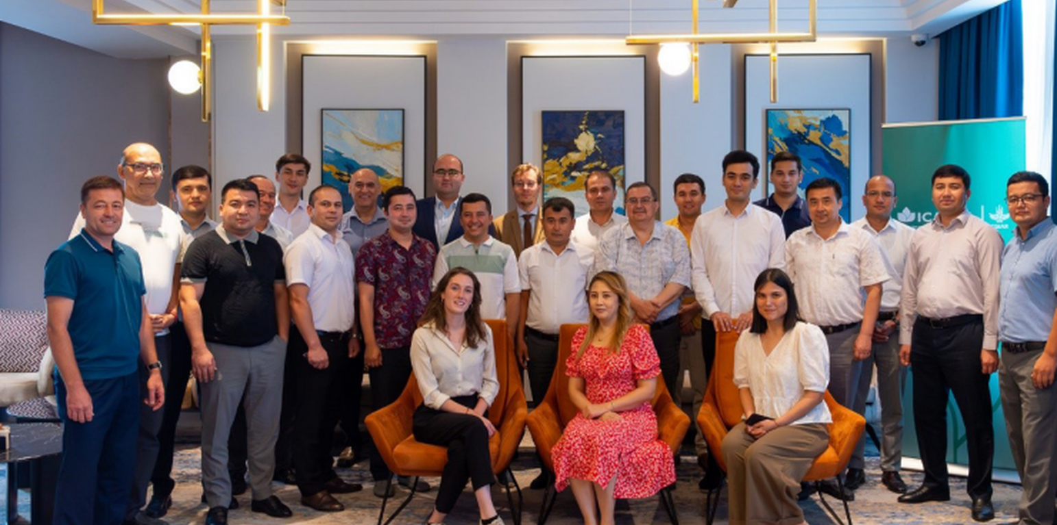
Group photo with the attendees of the second validation workshop
Land management and agricultural production often face diverse and conflicting interests from various stakeholders. The Water-Energy-Food-Ecosystem (WEFE) Nexus offers a framework for addressing these challenges. Under the CGIAR Nexus Gains Initiative, the International Center for Agricultural Research in the Dry Areas (ICARDA) developed a Decision Support Tool (DST) designed to help decision-makers balance stakeholder interests within the WEFE Nexus. The DST’s main objective is to enable comparison and thus prioritization of sustainable land management (SLM) technologies based on specific criteria and stakeholder-assigned weights.
The DST applies a multi-criteria analysis (MCA) framework combined with the Best-Worst Method (BWM) to capture stakeholder preferences and assign weights to different criteria. The MCA follows a hierarchical structure: the overarching goal of SLM is divided into sector-specific objectives for water, energy, food, and ecosystem health. Each is assessed through specific indicators, with stakeholder interviews used to derive weights and calculate a "Nexus Score"—a weighted average reflecting preferences for different SLM practices.
The tool’s development involved two field campaigns:
* The 2023 campaign gathered indicator values for SLM practices through field visits and interviews with farmers, ensuring data reflected field-level conditions. It concluded with a validation workshop leading to adjustments in the ranking system.
* The 2024 campaign focused on collecting stakeholder weights for indicators within the WEFE Nexus through key informant interviews. A workshop gathered stakeholders from ministries and research institutions, and updated participants on the DST’s development and preliminary findings, while collecting feedback.
Using the DST involves the following steps:
Identify Area: Define geographic boundaries, consult local SLM experts for technical validation, and engage stakeholders at local and regional levels.
Use the Tool: Download the DST, compile an inventory of local SLM practices, gather stakeholder weights, review and complete indicator values, generate results, and refine inputs.
Social Learning: Hold validation workshops with stakeholders to review DST outputs, foster knowledge sharing, and address concerns to build consensus.
Implementation: Based on validated DST outcomes and stakeholder input, implement agreed SLM practices.
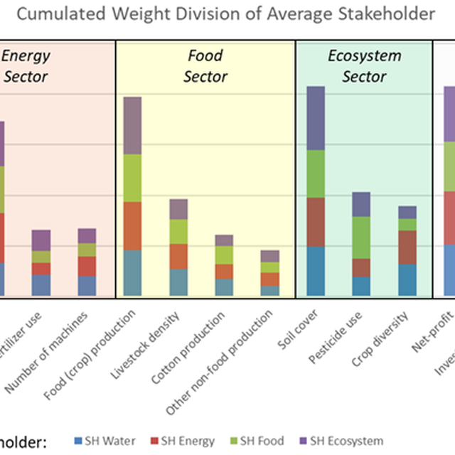
Overall, the DST aims to unite stakeholders in a shared understanding of land management decisions while addressing conflicting interests and policies. Findings reveal that departments often weigh indicators differently. Cross-departmental weight comparisons indicate shared priorities for certain criteria and highlight gaps in others, paving the way for interdepartmental collaboration.
The results of the weight survey provided notable insights. Within departments, responses exhibit a wide spread, indicating no collective priority. Across departments, certain criteria—such as reducing fuel consumption, food production, and net profit—are prioritized by all. Conversely, criteria like rain use efficiency, non-food production, and employment opportunities are collectively deprioritized.
This work was conducted under the CGIAR Initiative on Nexus Gains, with gratitude to the CGIAR Trust Fund contributors (www.cgiar.org/funders). The DST and approach are inspired by the thesis of J. Verbist, titled “Perspectives on the Economic Feasibility of Increasing Soil-Based Ecosystem Services on Arable Farms in The Netherlands” (2022), conducted at the Business Economics (BEC) Group of Wageningen University under the supervision of Professors H. Saatkamp and M. Kik.
الموقع: Tashkent (Uzbekistan), أوزبكستان
تاريخ البدء: 2022
سنة الإنهاء: غير متاح
نوع النهج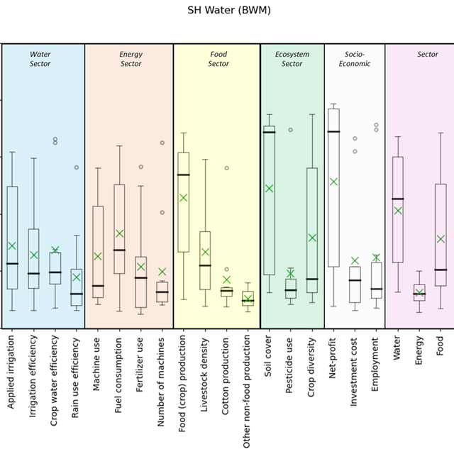
| ما هي الجهات المعنية / الكيانات المنفذة التي شاركت في النهج؟ | حدد الأطراف المعنيين | وصف أدوار الأطراف المعنية |
| مستخدمو الأراضي المحليون/المجتمعات المحلية | Farmers were interviewed to understand their preference and to quantify indicator values (e.g., how much fuel does their current practice consume) | |
| متخصصون في الإدارة المستدامة للأراضي / مستشارون زراعيون | Experts from the four WEFE departments | They were interviewed to get weights for indicators. |
| الباحثون | ICARDA | ICARDA developed the DST based on Multi-Criteria-Decision-Making (MCDM) literature. |
| الحكومة الوطنية (المخططون، صانعو القرار) | Four WEFE departments | These stakeholders implement and formulate policies for land management. |
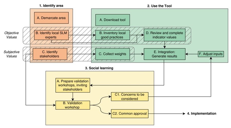
The Decision Support Tool (DST) facilitates the planning and implementation of Sustainable Land Management (SLM) practices through a structured process. The flow chart illustrates the four main phases of using the DST: identifying the area, utilizing the tool, promoting social learning, and implementing the plan. Each phase involves specific steps to ensure the tool’s effective use and stakeholder collaboration. The following guidelines provide a detailed explanation of these steps, guiding users from initial planning to final execution.
Objective Values: The first distinct process within the framework of the DST is the incorporation of objective values. These values are derived from measurable and verifiable data such as yield, fertilizer use, irrigation efficiency, and net-income. The DST leverages this quantitative information to assess how well different interventions perform across a range of technical criteria.
Subjective Values: The second process addresses the integration of subjective values, which stem from the perceptions, priorities, and preferences of stakeholders. These values are gathered through weighing, such as Direct Ranking or the Best-Worst Method (BWM), to reflect stakeholders’ interests, but also reflecting social and cultural dimensions. Incorporating subjective values ensures that the tool aligns with the needs and interests of the communities and stakeholders involved, fostering greater acceptance and ownership of the chosen SLM practices. This process emphasizes the importance of balancing technical efficiency with social relevance, resulting in a more holistic and inclusive decision-making process.
1. Identify Area
A.Demarcate Area: Define the geographical boundaries at the farm and watershed levels. These scales are suitable for applying the DST because the DST focusses on land management rather than more abstract national and policy levels.
B.Identify Local SLM Experts: Engage local experts in SLM early in the process to leverage their knowledge about the area’s specific practices and challenges. They are the right people to validate technical aspects of land management, which is invaluable regarding the indicator values.
C.Identify Stakeholders: Identify relevant stakeholders across different levels, including local authorities, farmers, and regional organizations. Even if broader-scale stakeholders (e.g., national ministries) are involved, focus on local or regional branches that directly influence the area.
2. Use the Tool
A.Download the Tool: Access the DST from ICARDA's Monitoring, Evaluation, and Learning (MEL) platform after defining the area and identifying stakeholders.
B.Inventory Local Good Practices: Review existing SLM practices and identify those most relevant for the area. The DST comes with predefined options, but additional practices can be added to reflect the local context.
C.Collect Weights: Gather weights for different indicators from stakeholders using methods like the Best-Worst-Method (BWM) or direct ranking. These weights will be used to reflect stakeholder preferences in the evaluation.
D.Review and Complete Indicator Values: Assess and adjust the default indicator values within the DST to better reflect local conditions, considering factors like soil properties, rainfall, and market conditions. In addition, when local SLM practices are added, these indicators values should also be given.
E.Generate Results: Use the weighted indicators to run the DST and produce visualizations and evaluations of various SLM options.
F.Adjust Inputs: If necessary, refine the input data based on insights gained during the tool’s use, allowing for recalibration of indicator values, weights, or additional local practices.
3. Social Learning
A.Prepare Validation Workshops, Inviting Stakeholders: Organize workshops with identified stakeholders to validate the DST’s outputs. Ensure that all relevant voices are heard, and prepare to address any concerns raised.
B.Validation Workshop: Facilitate a structured workshop where stakeholders can review and discuss the tool’s results. The workshop should encourage knowledge sharing and foster social learning. The DST is a mean to create common understanding and appreciation among WEFE stakeholders for sustainable land management.
C.Iterate:
C1. Concerns to be Considered: Document and address any issues or concerns raised by stakeholders during the workshop, potentially revising the DST inputs or methodology.
C2. Common Approval: Aim for a shared understanding and acceptance of the results, incorporating feedback from the validation process.
4. Implementation
Once the results are validated and any necessary adjustments have been made, proceed to implement the agreed-upon SLM practices. The plan should reflect the insights gained through the DST analysis and stakeholder feedback, ensuring that the execution phase aligns with the validated recommendations.
وقد تم اتخاذ القرارات من قبل
تم اتخاذ القرارات بناء على
A short course on the WEFE concept and its relation to land management was conducted, to build a common understanding.
A publication in Operations and Research was done. This paper elaborated on the need, concept, and use of the DST.
The DST requires input data such as indicators value and weight of these indicators. Therefore, the DST is also framework to elaborate decision and priorities in SLM/WEFE, increase evidence-based DM.
The DST shows where stakeholders can work together and where their action contradict, knowing this can lead to more cost-effective policies and improve coordination.
The DST revolves around WEFE Nexus, hence when presenting the DST, WEFE is also automatically considered as well, which enhanced the knowledge of the stakeholders.
The DST should lead to cross-department collaborations.


