Creating scale models for the development of lowland areas and the participation of the farming community [مالي]
- تاريخ الإنشاء:
- تحديث:
- جامع المعلومات: Dieter Nill
- المحرر: –
- المُراجع: Laura Ebneter
Elaboration des maquettes pour l’aménagement des bas-fonds et la participation paysanne
approaches_2500 - مالي
- Creating scale models for the development of lowland areas and the participation of the farming community: 7 يونيو، 2017 (inactive)
- Creating scale models for the development of lowland areas and the participation of the farming community: 7 يونيو، 2017 (inactive)
- Creating scale models for the development of lowland areas and the participation of the farming community: 7 يونيو، 2017 (inactive)
- Creating scale models for the development of lowland areas and the participation of the farming community: 12 يونيو، 2017 (public)
عرض الأقسام
توسيع الكل طي الكل1. معلومات عامة
1.2 تفاصيل الاتصال بالأشخاص الرئيسيين لمصدر المعلومات والمؤسسات المعنية بتقييم وتوثيق النهج
متخصص في الإدارة المستدامة للأراضي:
Keita Lassana
lassana.keita@helvetas.org
HELVETAS - Swiss Intercooperation
مالي
متخصص في الإدارة المستدامة للأراضي:
Dembélé Célestin
celestin.dembele@helvetas.org
HELVETAS - Swiss Intercooperation
مالي
متخصص في الإدارة المستدامة للأراضي:
Dacko Maïga Rosaline
rosaline.dacko@helvetas.org
HELVETAS - Swiss Intercooperation
مالي
اسم المؤسسة (المؤسسات) التي سهلت توثيق/تقييم النهج (إذا كان ذلك على صلة)
HELVETAS (Swiss Intercooperation)اسم المؤسسة (المؤسسات) التي سهلت توثيق/تقييم النهج (إذا كان ذلك على صلة)
Deutsche Gesellschaft für Internationale Zusammenarbeit (GIZ) GmbH (GIZ) - ألمانيا1.3 الشروط المتعلقة باستخدام البيانات الموثقة من خلال WOCAT
متى تم تجميع البيانات (ميدانيا)؟:
01/07/2012
يوافق جامع المعلومات والشخص (لاشخاص) الرئيسي لمصدر المعلومات على الشروط المتعلقة باستخدام البيانات الموثقة من خلال WOCAT:
نعم
2. وصف نهج الإدارة المستدامة للأراضي
2.1 وصف موجز للنهج
Creating models when developing lowland areas encourages the different actors involved to enter into negotiations and participate in decision-making on the design and farming of a lowland area.
2.2 وصف تفصيلي للنهج
وصف تفصيلي للنهج:
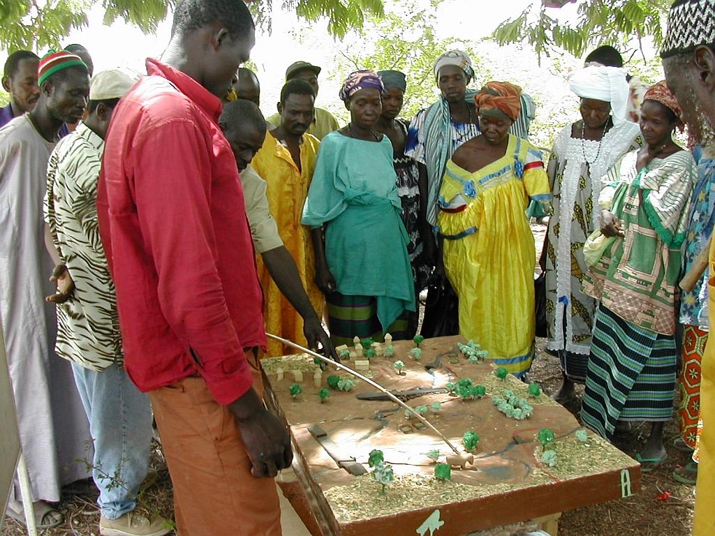
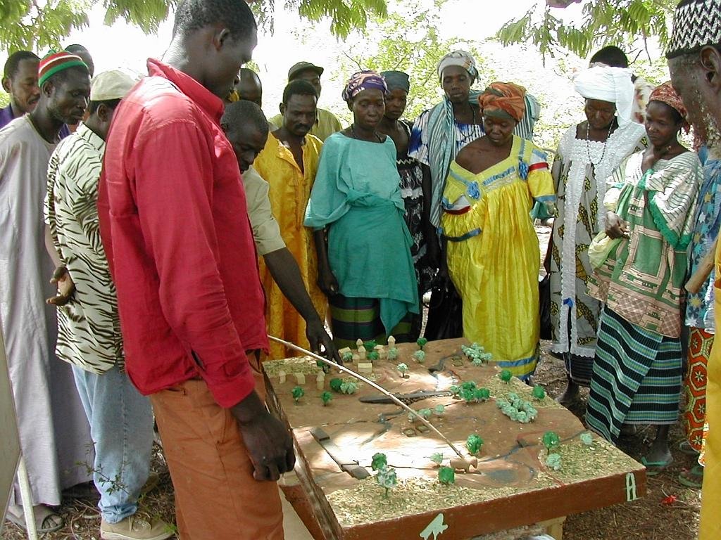
Scale models are an instructional tool that can be used to ensure a common understanding of the characteristics of the lowland area to be developed, give concrete expression to the baseline scenario, and facilitate discussion of the different technical options for the development. Depending on the case at hand, the model shows flooded areas, forested areas, housing, areas given over to pasture or cultivation and the type of scheme that has been chosen with the beneficiaries. Ultimately, a wooden 3D version of the model is produced that is around 80 x 120 centimetres in size. The model is a visual aid that improves communication between the different actors involved and the technical designers during the planning process and development of the lowland area (communities, design agencies and businesses tasked with implementation, etc.). The model is a tool that helps to foster the actors’ ownership of the process, the creation of a shared future vision of the development, and the collaborative management of schemes. It must, however, form part of an overall facilitation approach.
The model is one tool in the toolkit of lowland planning approaches. The process begins with the request by a community and/or local authority for a scheme. A brief for the development scheme is then drawn up jointly by those involved. The project itself starts with a socio-economic study carried out in accordance with the ToR submitted to the community. Approval for the choice of site is obtained in the course of the socio-economic study, which leads into a technical study based on the findings and the summary draft document (SDD). Study findings are fed back to villagers along with the selected scenario. A 3D wooden model is then produced on the basis of the findings and scenario. The other scheme implementation stages are carried out following approval (summary draft document – SDD, drafting of the tender documents – ITD, choice of contractor, works, approval of works completed). The model is subsequently used to move the farming and facility maintenance strategy forward. Two or three village facilitators, who are members of the management committee, are trained in how to handle the model during facilitation sessions.
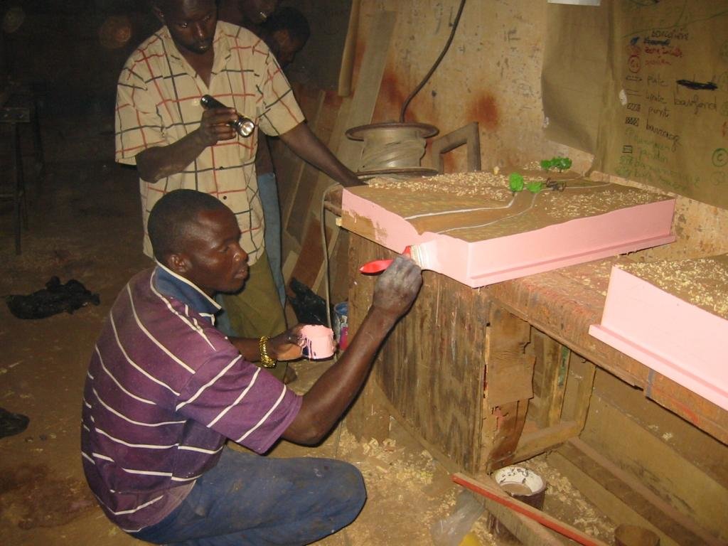
Stages in creating a model: 1)Sketch mapping (involving farmers) and a topographical survey of the area, 2)Precise order placed with the model maker (specification), 3)Provision of a quote by the model maker setting out the costs of the materials and services required (if necessary, a site visit is carried out with the model maker to work through the paper maps of the lowland area), 4)Conversion of the paper maps to the actual scale of the model, 5)Production of the base unit with the basic relief (boards, plywood), 6)Positioning of the technical features to be installed (facilities, roads, irrigated plots, ponds, etc.) and the addition of decorative elements (houses, trees, livestock), 7)Production of a protective shipping case for the model.
Beneficiaries formulate the request, describe and draw sketch maps of the landscape, and use the model in consultation exercises. The consultancy supports the design process, ensures the quality
of on-paper designs for use in constructing the model, and acts as intermediary between the beneficiaries and the woodworker, particularly in terms of converting scales and proportions. The woodworker creates the model according to the plan.
2.3 صور عن النهج
2.5 البلد/المنطقة/المواقع التي تم تطبيق النهج فيها
البلد:
مالي
المنطقة/الولاية/المحافظة:
Mali
مزيد من التفاصيل حول الموقع:
Sikasso, Koutiala, Kadiolo and Yorosso, San and Tominian
2.6 تواريخ بدء وإنهاء تنفيذ النهج
أشر إلى سنة البدء:
2005
2.7 نوع النهج
- قائم على مشروع/برنامج
2.8 الغايات/الأهداف الرئيسية للنهج
The Approach focused mainly on SLM with other activities.
Encouraging the different actors to enter into negotiations and participate in decision-making on the design and farming of a lowland areas; reduction of conflicts over farming land
The SLM Approach addressed the following problems: lack of participation of the farming community in the development of lowland areas, conflicts over farming land
2.9 الظروف التي تمكن أو تعيق تنفيذ التقنية/التقنيات المطبقة بموجب النهج
الإطار المؤسساتي
- معيق
lack of participation of the farming community in the development of lowland areas
Treatment through the SLM Approach: Creating models when developing lowland areas encourages the different actors involved to enter into negotiations and participate in decision-making on the design and farming of a lowland area.
3. المشاركة وأدوار الأطراف المعنية
3.1 أصحاب المصلحة المعنيون بالنهج وأدوارهم
- مستخدمو الأراضي المحليون/المجتمعات المحلية
- متخصصون في الإدارة المستدامة للأراضي / مستشارون زراعيون
- منظمة غير حكومية
HELVETAS
- الحكومة الوطنية (المخططون، صانعو القرار)
3.2 انخراط مستخدمي الأراضي المحليين/المجتمعات المحلية في المراحل المختلفة للنهج
| انخراط مستخدمي الأراضي المحليين/المجتمعات المحلية | حدد من شارك وصف الأنشطة | |
|---|---|---|
| المبادرة/التحفيز | سلبي | |
| التخطيط | تفاعلي | |
| التنفيذ | تفاعلي | |
| الرصد/التقييم | سلبي | |
| Research | سلبي |
3.4 اتخاذ القرار بشأن اختيار تقنية/تقنيات الإدارة المستدامة للأراضي
حدد من الذي قرر اختيار التقنية/التقنيات التي سيتم تنفيذها:
- متخصصون في الإدارة المستدامة للأراضي بشكل أساسي، بعد التشاور مع مستخدمي الأراضي
اشرح:
Decisions on the method of implementing the SLM Technology were made by mainly by SLM specialists with consultation of land users
4. الدعم الفني وبناء القدرات وإدارة المعرفة
4.1 بناء القدرات/التدريب
هل تم تقديم التدريب لمستخدمي الأراضي / الأطراف المعنيين الآخرين؟:
نعم
حدد من تم تدريبه:
- مستخدمو الأراضي
شكل التدريب:
- اجتماعات عامة
- دورات
المواضيع المغطاة:
Local people need to get to grips with the landscape and know how to orientate themselves in the space. The model maker must be well trained and have expertise in concepts of scale, contours and ‘scale exaggerations’
4.2 خدمة استشارية
هل يملك مستخدمو الأراضي وصولا إلى خدمة استشارية؟:
نعم
حدد ما إذا كانت الخدمة الاستشارية متوفرة:
- في حقول مستخدمي الأراضي
وصف/تعليقات:
Advisory service is quite adequate to ensure the continuation of land conservation activities; the model is facilitated by villagers themselves
4.3 تعزيز المؤسسات (التطوير التنظيمي)
هل تم إنشاء أو تعزيز مؤسسات من خلال هذا النهج؟:
- نعم، باعتدال
حدد المستوى (المستويات) التي تم فيها تعزيز أو إنشاء المؤسسات:
- محلي
حدد نوع الدعم:
- بناء القدرات/التدريب
- معدات
4.4 الرصد والتقييم
هل يشكل الرصد والتقييم جزءا من النهج؟:
نعم
التعليقات:
technical aspects were ad hoc monitored by project staff through observations
socio-cultural aspects were ad hoc monitored by project staff through observations
management of Approach aspects were ad hoc monitored by project staff through observations
There were no changes in the Approach as a result of monitoring and evaluation
There were no changes in the Technology as a result of monitoring and evaluation
4.5 البحوث
هل كانت البحوث جزءًا من النهج؟:
نعم
حدد المواضيع:
- علم الاجتماع
- الاقتصاد / التسويق
- علم الايكولوجيا
- تكنولوجيا
أعط تفاصيل إضافية وأشر إلى من قام بالبحوث:
Helvetas - Swiss Intercooperation
5. التمويل والدعم المادي الخارجي
5.1 الميزانية السنوية لمكون الإدارة المستدامة للأراضي في النهج المذكور
إذا لم تكن الميزانية السنوية الدقيقة معروفة، قم بالإشارة إلى نطاقها:
- < 2000
التعليقات (على سبيل المثال المصادر الرئيسية للتمويل/الجهات المانحة الرئيسية):
Approach costs were met by the following donors: international non-government: 100.0%
5.2 الدعم المالي/المادي المقدم لمستخدمي الأراضي
هل حصل مستخدمو الأراضي على دعم مالي/ مادي لتنفيذ التقنية/ التقنيات؟:
نعم
5.3 إعانات لمدخلات محددة (بما في ذلك العمالة)
إذا كان العمل من قبل مستخدمي الأراضي مدخلاً جوهريًا، فهل كان:
- تطوعي
5.4 الائتمان
هل تم توفير ائتمان في إطار نهج أنشطة الإدارة المستدامة للأراضي؟:
كلا
6. تحليل الأثر والتصريحات الختامية
6.1 آثار النهج
هل ساعد النهج مستخدمي الأراضي على تنفيذ وصيانة تقنيات الإدارة المستدامة للأراضي؟:
- لا
- نعم، قليلا
- نعم، باعتدال
- نعم، إلى حد كبير
reduced conflicts over farming land and immediate visibility of the land pattern and spatial issues
هل ساهم النهج في تمكين الفئات المحرومة اجتماعيا واقتصاديا؟:
- لا
- نعم، قليلا
- نعم، باعتدال
- نعم، إلى حد كبير
It is an approach that is more engaging and accessible to all – even the shyest people are able to express themselves.
Did other land users / projects adopt the Approach?
- لا
- نعم، قليلا
- نعم، باعتدال
- نعم، إلى حد كبير
This tool has been used in the regions of Sikasso (Sikasso, Koutiala, Kadiolo and Yorosso) and Ségou (San and Tominian) for all the schemes delivered by HELVETAS Swiss Intercooperation. In total, more than 25 models have been made.
Did the Approach lead to improved livelihoods / human well-being?
- لا
- نعم، قليلا
- نعم، باعتدال
- نعم، إلى حد كبير
The model is tangible, durable and helps reduce social conflict. Involvement and motivation of local people in the design process is ensured. The model enables stakeholders to interpret the landscape and thus helps them in the decision-making process. It is used in consultation exercises to ensure transparency and consensual management in the implementation and evaluation of the scheme.
Did the Approach help to alleviate poverty?
- لا
- نعم، قليلا
- نعم، باعتدال
- نعم، إلى حد كبير
6.2 المحفز الرئيسي لقيام مستخدمي الأراضي بتنفيذ الإدارة المستدامة للأراضي
- زيادة الإنتاج
- زيادة الربح (القدرة)، وتحسين نسبة التكلفة إلى العائد
- المدفوعات/ الإعانات
- الوعي البيئي
- well-being and livelihoods improvement
6.3 استدامة أنشطة النهج
هل يمكن لمستخدمي الأراضي المحافظة على استدامة ما تم تنفيذه من خلال النهج (بدون دعم خارجي)؟:
- نعم
6.4 نقاط قوة/مزايا النهج
| نقاط القوة/ المزايا/ الفرص من وجهة نظر جامع المعلومات أو غيره من الاشخاص الرئيسيين لمصدر المعلومات |
|---|
| The results are immediate and manifest as: reduced conflicts over farming the land in question; the immediate visibility of the land pattern and spatial issues; the involvement and motivation of local people in the design process; more inclusive decisions and the initiation of social dialogue on the scheme; an approach that is more engaging and accessible to all – even the shyest people are able to express themselves. (How to sustain/ enhance this strength: The approach must be participatory; it should not exclude any sector of society. In this respect, young people and women prove to be very good facilitators, with the model helping them to present the subject matter in a lively and engaging way.) |
|
The model enables stakeholders to interpret the landscape and thus helps them in the decision-making process. It is used in consultation exercises to ensure transparency and consensual management in the implementation and evaluation of the scheme. (How to sustain/ enhance this strength: To use the model, all that is required is for it to be transported to the meeting/facilitation space, removed from its case and placed at table height or even on the ground. The facilitator then introduces the project, indicating the landmarks and cardinal directions. This serves as the basis for discussion. Local people need to get to grips with the landscape and know how to orientate themselves in the space. The model maker must be well trained and have expertise in concepts of scale, contours and ‘scale exaggerations’. They must have an artist’s eye. ) |
| The model is tangible, durable and helps reduce social conflict. It also serves as a support for meetings with visitors. It is facilitated by villagers themselves. |
6.5 نقاط الضعف/ العيوب في المنهج وطرق التغلب عليها
| نقاط الضعف/ المساوىء/ المخاطر من وجهة نظر جامع المعلومات أو غيره من الاشخاص الرئيسيين لمصدر المعلومات | كيف يمكن التغلب عليها؟ |
|---|---|
| Some experts from technical consultancies have the tendency to take over from the beneficiaries. Other public sector experts move things forward as quickly as possible and fail to take into account villagers’ contributions. |
To ensure that people are not left frustrated and, as a result, participate less in the process, it is important to give them the opportunity to express their views. |
| Modifications may be required once the model is completed. Integrating these corrections can prove difficult (engaging the same provider and carrying out alterations without diminishing the appearance of the model). |
7. المراجع والروابط
7.1 طرق جمع/مصادر المعلومات
- زيارات ميدانية، مسوحات ميدانية
- مقابلات مع مستخدمي الأراضي
7.2 المراجع للمنشورات المتاحة
العنوان، المؤلف، السنة، النظام القياسي الدولي لترقيم الكتب ISBN:
Intercooperation, Délégation au Sahel (n.d.): Capitalisation d’éxperience. Eau, terre, communautés. La maquette pédagogique transportable dans l’aménagement des bas-fonds. Un outil pour les practiciens. [Delegation to the Sahel (n.d.): Capitalising on experiences. Water, land, communities. The portable instructional model for developing lowland schemes. A tool for practitioners.]
متاح من أين؟كم التكلفة؟:
http://agriwaterpedia.info/wiki/Main_Page
العنوان، المؤلف، السنة، النظام القياسي الدولي لترقيم الكتب ISBN:
Intercooperation, Délégation au Sahel (2009): Gestion des ressources naturelles: les acteurs s’engagent pour une gestion concertée et pacifique de leurs resources. [Delegation to the Sahel (2009): Management of natural resources – actors engage in the collaborative and peaceful management of their resources.]
العنوان، المؤلف، السنة، النظام القياسي الدولي لترقيم الكتب ISBN:
Good Practices in Soil and Water Conservation. A contribution to adaptation and farmers´ resilience towards climate change in the Sahel. Published by GIZ in 2012.
متاح من أين؟كم التكلفة؟:
http://agrwaterpedia.info/wiki/Main_Page
الروابط والوحدات المواضيعية
توسيع الكل طي الكلالروابط
لا يوجد روابط
الوحدات المواضيعية
لا يوجد وحدات مواضيعية


