E-Prakriti - An Approach Towards GIS Based Planning For Natural Farming [الهند]
- تاريخ الإنشاء:
- تحديث:
- جامع المعلومات: Santosh Gupta
- المحررون: Noel Templer, Stephanie Katsir, Tabitha Nekesa, Ahmadou Gaye, Siagbé Golli
- المراجعون: Rima Mekdaschi Studer, Udo Höggel, Joana Eichenberger, Sally Bunning
E-Prakriti
approaches_6726 - الهند
عرض الأقسام
توسيع الكل طي الكل1. معلومات عامة
1.2 تفاصيل الاتصال بالأشخاص الرئيسيين لمصدر المعلومات والمؤسسات المعنية بتقييم وتوثيق النهج
اسم المشروع الذي سهّل توثيق/تقييم النهج (إذا كان ذلك على صلة)
Soil protection and rehabilitation for food security (ProSo(i)l)اسم المؤسسة (المؤسسات) التي سهلت توثيق/تقييم النهج (إذا كان ذلك على صلة)
Deutsche Gesellschaft für Internationale Zusammenarbeit (GIZ)اسم المؤسسة (المؤسسات) التي سهلت توثيق/تقييم النهج (إذا كان ذلك على صلة)
Alliance Bioversity and International Center for Tropical Agriculture (Alliance Bioversity-CIAT) - كينيااسم المؤسسة (المؤسسات) التي سهلت توثيق/تقييم النهج (إذا كان ذلك على صلة)
Ecociate Consultants (Ecociate Consultants) - الهند1.3 الشروط المتعلقة باستخدام البيانات الموثقة من خلال WOCAT
يوافق جامع المعلومات والشخص (لاشخاص) الرئيسي لمصدر المعلومات على الشروط المتعلقة باستخدام البيانات الموثقة من خلال WOCAT:
نعم
2. وصف نهج الإدارة المستدامة للأراضي
2.1 وصف موجز للنهج
The e-Prakriti approach is a GIS-based planning approach that integrates natural farming interventions for effective management, monitoring, and conservation of natural resources at the landscape level. It can be applied for projects such as soil and water management, land reclamation, crop and seed systems design and agri-infrastructure mapping. To establish and maintain an e-Prakriti system, it is necessary to collect and manage data effectively, to build capacity among stakeholders, to have the appropriate technology infrastructure in place and to promote the engagement of local communities with conservation organizations.
2.2 وصف تفصيلي للنهج
وصف تفصيلي للنهج:
The e-Prakriti approach is a planning method that utilizes GIS tools to integrate ecosystem-based natural farming interventions into agricultural operations. It focuses on creating scientific and efficient planning techniques that consider the landscape as a unit, such as a Village, Block, District and watersheds or river basins. This approach uses open-source datasets, including spatial and non-spatial data, to develop a comprehensive activity plan for natural resource management at a landscape level and having natural farming approaches as its core.
To facilitate the planning process using the various open-source platforms, GIZ has developed a comprehensive guide cum training module under the Pro-Soil Project. This guide comprehensively captures the different open-source platforms and their application to the local context, so to plan and implement natural-farming based interventions. The guide can be used to build the capacity of local-community resource persons, members of local self-governance (Panchayati Raj) institutions and other projects working at the village or cluster level.
The primary purpose of e-Prakriti is to enable effective and efficient management, monitoring, and conservation of natural resources, including sustainable soil management, water management, degraded land reclamation, crop and seed system design, bio-resource and fodder assessment, agro-infrastructure mapping, and the planning of sustainable enterprises. This e-Prakriti approach is used to conduct inventory and management of natural resources, such as forests, wetlands, and wildlife habitats, by mapping the extent and distribution of these resources and tracking their use and status over time. The e-Prakriti approach monitors changes in natural resources, evaluates the effectiveness of conservation measures, and identifies areas that require further intervention. Additionally, e-Prakriti technology can support planning and decision-making related to natural resource management by identifying areas most suitable for conservation or development activities.
Establishing and maintaining an e-Prakriti approach requires data collection on natural resources, effective data management, building capacity among stakeholders, appropriate technology infrastructure and institutional support. The benefits and impacts of the e-Prakriti approach include promoting sustainable development, improving natural resource management, reducing disaster risks, increasing community participation, improving policy and decision-making and conserving biodiversity. Land users' perceptions and experiences of e-Prakriti may vary depending on factors such as socio-economic background, level of education, cultural values and their relationship with natural resources. It is important to consider these factors when designing and implementing e-Prakriti approaches to meet the needs and expectations of land users.
GIZ has collaborated with the State Rural Livelihood Mission of Madhya Pradesh (MP-SRLM) for the practical application of the e-Prakriti approach in the planning process by the local community resource persons. GIZ provides training and operational support to team members for the successful application of e-Prakriti approaches in day-to-day work.
2.3 صور عن النهج
ملاحظات عامة بخصوص الصور:
e-Prakriti proposes comprehensive planning by the adequate blending of technology with sustainability approaches, local wisdom, community participation, and departmental convergence.
2.5 البلد/المنطقة/المواقع التي تم تطبيق النهج فيها
البلد:
الهند
المنطقة/الولاية/المحافظة:
Madhya Pradesh
مزيد من التفاصيل حول الموقع:
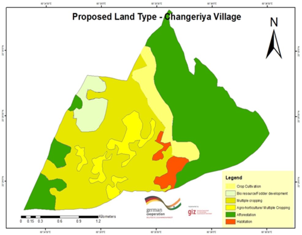
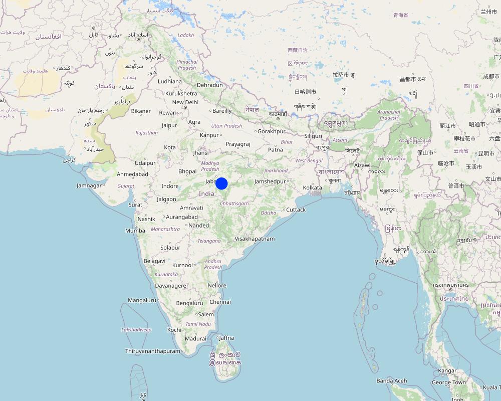
Changariya village, Bichiya block,
التعليقات:
The Changariya village is a sample site to understand the E-prakriti workbook approach
Map
×2.6 تواريخ بدء وإنهاء تنفيذ النهج
في حالة عدم معرفة السنة بالتحديد، يرجى الإشارة إلى التاريخ التقريبي لبدء النهج:
منذ أقل من 10 سنوات (مؤخرًا)
سنة الإنهاء (إذا لم يعد النهج مطبقًا):
2023
التعليقات:
This approach for landscape management considers the landscape as an administrative and natural unit and includes various levels such as Village, Block, District, and geo-hydrological landscapes. It provides a comprehensive activity plan for the management of natural resources, with a focus on natural farming as a core component. The approach is easy to understand and can be used for project implementation.
2.7 نوع النهج
- قائم على مشروع/برنامج
2.8 الغايات/الأهداف الرئيسية للنهج
The objective of this tool is to create a scientific and efficient approach for planning natural farming interventions through the use of GIS-based mapping
2.9 الظروف التي تمكن أو تعيق تنفيذ التقنية/التقنيات المطبقة بموجب النهج
المعايير والقيم الاجتماعية /الثقافية/ الدينية
- تمكين/تمكيني
E-prakriti proposes comprehensive planning by the adequate blending of technology with sustainability approaches, local wisdom, community participation and departmental convergence
الإطار المؤسساتي
- تمكين/تمكيني
The effective cooperation of actors like communities, Government Departments and other institutions is enabled by natural-farming planning approaches using GIS Tools.
التعاون/التنسيق بين الجهات الفاعلة
- تمكين/تمكيني
The validation of GIS data is done through on-ground validation and extensive interpretation from maps. Community consultations are crucial in the planning process and convergence planning with the concerned Government Departments is necessary for comprehensive planning. Technical training in basic GIS-based software handling is essential for departmental engineers and other technically competent functionaries.
المعرفة حول الإدارة المستدامة للأراضي، والوصول إلى الدعم الفني
- تمكين/تمكيني
عبء العمل، توفر القوى العاملة
- تمكين/تمكيني
e-Prakriti can significantly reduce the workload of planners and implementers as it reduces the need for physical visits to each and every village to collect ground-level data. A lot of data with very high accuracy can be collected from the satellite-based imaging systems.
3. المشاركة وأدوار الأطراف المعنية
3.1 أصحاب المصلحة المعنيون بالنهج وأدوارهم
- مستخدمو الأراضي المحليون/المجتمعات المحلية
Local community members, farmers
They have provided the data and information during the ground proofing exercises
- المنظمات المجتمعية
Local Community - Participation of local groups in implementing the program activities.
Community representatives from villages - support/drive the program's activities.
Community consultations are critical in promoting sustainable development interventions. It is vital to adequately prepare the community for the actions required, and community representatives must be involved at all planning levels, starting from the ground level. The principles of inclusivity and cooperation are crucial in building trust and promoting effective collaboration among community members.
The community's input is essential in creating a suitable action plan and developing maps at the beginning and end of the planning process through larger community consultations. By involving the community in this way, the intervention is more likely to be successful, sustainable and aligned with the community's needs and aspirations. This approach ensures that the community is adequately prepared to undertake the required actions and the intervention is more likely to have a positive impact on the community's well-being in the long run.
- متخصصون في الإدارة المستدامة للأراضي / مستشارون زراعيون
1. Team from GIZ and consultants who developed the e-Prakriti module
2. Specialist from project implementing team
SLM specialists from GIZ, from the implementing agency, other consultants from the domain of GIS and satellite-based applications have developed the e-Prakriti module. They have looked into the specific requirements for planning the natural farming interventions and available open source platforms to meet that requirement. Once this is developed they also did some ground truthing exercises in the field to observe the accuracy of collected data along with application in the field.
- المعلمون / أطفال المدارس / الطلاب
Local Community Representative (Community Resource Person)
The CRP is trained to use the E-Prakriti tools for planning natural farming practices. He/she engages with village groups and the program team for planning, implementation and execution. They are considered the most important stakeholders in the process as it is expected that CRPs will use this tool in the planning of their activities.
- منظمة غير حكومية
Foundation for Ecological Security (FES) NGO
FES is involved in piloting the approach in villages, handholding for the implementation and monitoring the work. Scaling up plans with different agencies is undertaken once the piloting is successful and evidence is generated.
- الحكومة المحلية
Gram Panchayat (village self governing body)
Liaison with different government departments concerned viz. Departments like Water
Resource, NREGS, Animal Husbandry, Agriculture, Horticulture, Panchayat etc.
Convergence planning is crucial for the successful implementation of natural farming as it extensively relies on the utilization of common natural resources. This can only be achieved through the integrated effort of various concerned Departments, such as Water Resources, NREGS, Animal Husbandry, Agriculture, Horticulture, Panchayat, etc.
Therefore, it is essential to hold joint consultations with these departments to ensure that everyone is on the same page and has a shared understanding of the objectives and strategies for natural farming. These consultations can help to identify the potential areas of collaboration and the specific roles and responsibilities of each department in the implementation of natural farming practices.
In addition to engaging with the relevant departments, it is equally important to involve the district administration in the planning process. The District Collector, CEO of Zila, and Block Panchayat can play a facilitative role in bringing together the various departments and stakeholders involved in natural farming, promoting collaboration and convergence among them.
Through effective convergence planning, it is possible to achieve better coordination and utilization of resources, resulting in improved outcomes for natural farming. This will also contribute to the sustainable development of rural communities and the conservation of natural resources in the long run.
- منظمة دولية
Deutsche Gesellschaft für Internationale Zusammenarbeit (GIZ) GmbH
Collated the experiences and prepared the workbook that gives an
overview of planning for natural farming using open-source data
3.2 انخراط مستخدمي الأراضي المحليين/المجتمعات المحلية في المراحل المختلفة للنهج
| انخراط مستخدمي الأراضي المحليين/المجتمعات المحلية | حدد من شارك وصف الأنشطة | |
|---|---|---|
| المبادرة/التحفيز | سلبي | They have been discussed to understand their specific needs, resources availability and applications for developing the basic understanding |
| التخطيط | تفاعلي | Local community institutions were involved in the process of planning to understand the local cost specifications, local cropping patterns and to collect and validate the data points |
| التنفيذ | التعبئة الذاتية | Local community institutions did implement the interventions with technical guidance from the project implementing team |
| الرصد/التقييم | تفاعلي | During the monitoring process images and data points collected from the satellites were physically validated from the community members. Also, discussions are held with communities to understand the social and economic impact of the project interventions. |
3.3 مخطط التدفق (إذا كان متاحًا)
الوصف:
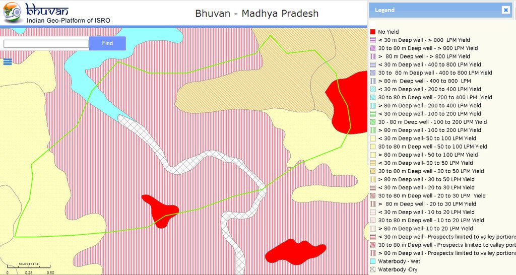
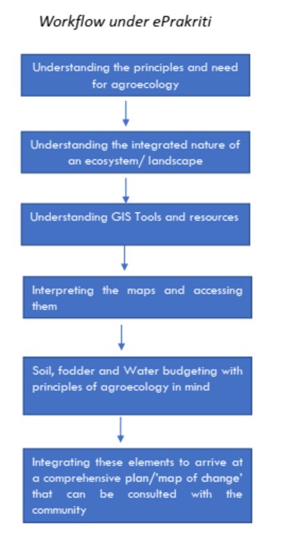
In order to effectively plan for natural farming using GIS tools, it is important to involve the larger systems around the community and the community itself. The first step is to identify and define a unit of intervention, such as a village. Open-source satellite data can then be used to understand and estimate various factors such as geomorphology and geohydrology. This data can be complemented with other available data from sources such as the Ground Water Board or the NREGS portal.
Using QGIS tool, the various data sets can be superimposed to find relationships between them. On-ground validation (truthing) of the GIS data is also necessary to ensure its accuracy. Once the data sets are gathered, an extensive interpretation from maps is undertaken, and the data is translated into easily understandable and implementable material for the community.
Community consultations are a critical part of the intervention, with community representatives being involved at all levels of planning. Inclusivity and cooperation are key principles in engaging the community and government departments and institutions for the judicious use of common resources. Larger community consultations are held at the beginning and end of the planning process to arrive at a suitable action plan using the prepared maps.
The planned actions and locations are plotted on maps on Google Earth, and convergence planning is necessary for the integrated efforts of several concerned departments. Joint consultations are held with these departments, and the district administration can play a facilitative role in bringing everyone on the same page. Lastly, it is important to train departmental engineers, Rozgar Sahayaks, and other technically competent functionaries in basic GIS-based software such as Bhuvan, QGIS, India-WRIS, and Bhuvan Panchayat to extract necessary data.
المؤلف:
Deutsche Gesellschaft für Internationale Zusammenarbeit (GIZ) GmbH
3.4 اتخاذ القرار بشأن اختيار تقنية/تقنيات الإدارة المستدامة للأراضي
حدد من الذي قرر اختيار التقنية/التقنيات التي سيتم تنفيذها:
- جميع الجهات الفاعلة ذات الصلة، كجزء من نهج تشاركي
حدد على أي أساس تم اتخاذ القرارات:
- نتائج البحوث
- خبرة وآراء شخصية(غير موثقة)
4. الدعم الفني وبناء القدرات وإدارة المعرفة
4.1 بناء القدرات/التدريب
هل تم تقديم التدريب لمستخدمي الأراضي / الأطراف المعنيين الآخرين؟:
نعم
حدد من تم تدريبه:
- موظفون ميدانيون/ مستشارون
إذا كان ذلك على صلة، حدد الجنس والعمر والوضع والعرق وما إلى ذلك.
The Community resource person is trained on different maps and related interpretations. The first level of planning is made using open GIS sources which are later validated by the CRP along with the community in the village. Once the plan is finalized in a participatory manner, the program is implemented and monitored using the GIS tool.
شكل التدريب:
- في العمل
- مناطق العرض
- دورات
المواضيع المغطاة:
1 Village boundaries
2 Village Assets and Infrastructure
3 Watershed / Sub-basin Map
4 Natural Drainage line
8 Availability of groundwater
5 Further resources on Water
5 Geomorphology
6 Slopes within the topography
7 Lineaments- cracks in the land for the generation of aquifiers
8 Soil Erosion
10 Soil kinds/data
11 Land usage pattern
12 Crop season land
13 Wastelands Map
التعليقات:
E-Prakriti is a training module which can be used by various stakeholders for the training and handholding of field team members.
4.2 خدمة استشارية
هل يملك مستخدمو الأراضي وصولا إلى خدمة استشارية؟:
نعم
حدد ما إذا كانت الخدمة الاستشارية متوفرة:
- في حقول مستخدمي الأراضي
4.3 تعزيز المؤسسات (التطوير التنظيمي)
هل تم إنشاء أو تعزيز مؤسسات من خلال هذا النهج؟:
- لا
4.4 الرصد والتقييم
هل يشكل الرصد والتقييم جزءا من النهج؟:
نعم
التعليقات:
This tool can be used for monitoring the project interventions by having the pre- and post-project images from the satellite
إذا كانت الإجابة بنعم، فهل من المقصود استخدام هذه الوثائق للمراقبة والتقييم؟:
كلا
4.5 البحوث
هل كانت البحوث جزءًا من النهج؟:
كلا
5. التمويل والدعم المادي الخارجي
5.1 الميزانية السنوية لمكون الإدارة المستدامة للأراضي في النهج المذكور
إذا لم تكن الميزانية السنوية الدقيقة معروفة، قم بالإشارة إلى نطاقها:
- < 2000
التعليقات (على سبيل المثال المصادر الرئيسية للتمويل/الجهات المانحة الرئيسية):
The major cost involved is in developing the e-Prakriti module, the cost of which was incurred by the GIZ.
Another important cost component is capacity building of the stakeholders.
5.2 الدعم المالي/المادي المقدم لمستخدمي الأراضي
هل حصل مستخدمو الأراضي على دعم مالي/ مادي لتنفيذ التقنية/ التقنيات؟:
كلا
5.3 إعانات لمدخلات محددة (بما في ذلك العمالة)
- غير موجود
5.4 الائتمان
هل تم توفير ائتمان في إطار نهج أنشطة الإدارة المستدامة للأراضي؟:
كلا
5.5 حوافز أو وسائل أخرى
هل تم استخدام حوافز أو أدوات أخرى لتشجيع تنفيذ تقنيات الإدارة المستدامة للأراضي؟:
نعم
إذا كانت الإجابة بنعم، حدد:
Training and handholding of stakeholders
6. تحليل الأثر والتصريحات الختامية
6.1 آثار النهج
هل ساهم النهج في تمكين مستخدمي الأراضي المحليين وتحسين مشاركة الأطراف المعنية؟:
- لا
- نعم، قليلا
- نعم، باعتدال
- نعم، إلى حد كبير
The targeted areas that specifically needed conservation work were focused on
هل مكّن النهج من اتخاذ القرارات المبنية على الأدلة؟:
- لا
- نعم، قليلا
- نعم، باعتدال
- نعم، إلى حد كبير
This has been the most important purpose of this approach. The use of various spatial tools ensured evidence-based decision-making
هل ساعد النهج مستخدمي الأراضي على تنفيذ وصيانة تقنيات الإدارة المستدامة للأراضي؟:
- لا
- نعم، قليلا
- نعم، باعتدال
- نعم، إلى حد كبير
The approach may be a great tool for effective and efficient natural farming-based practices and other SLM technologies
هل نجح النهج في تحسين التنسيق والتنفيذ الفعال من حيث التكلفة لأنشطة الإدارة المستدامة للأراضي؟:
- لا
- نعم، قليلا
- نعم، باعتدال
- نعم، إلى حد كبير
Yes. It has been of great use
هل نجح النهج في تعبئة/تحسين الوصول إلى الموارد المالية لتنفيذ الإدارة المستدامة للأراضي؟:
- لا
- نعم، قليلا
- نعم، باعتدال
- نعم، إلى حد كبير
Developing projects using the technology has ensured effective financial planning for the planned interventions
هل أدى النهج إلى تحسين معرفة وقدرات مستخدمي الأراضي على تنفيذ الإدارة المستدامة للأراضي؟:
- لا
- نعم، قليلا
- نعم، باعتدال
- نعم، إلى حد كبير
Land users and local community resource persons learned about the various tools and technologies available for scientific planning
هل أدى النهج إلى تحسين معرفة وقدرات الأطراف المعنية الأخرى؟:
- لا
- نعم، قليلا
- نعم، باعتدال
- نعم، إلى حد كبير
Community resource persons
هل ساهم النهج في بناء/تعزيز المؤسسات والتعاون بين الأطراف المعنية؟:
- لا
- نعم، قليلا
- نعم، باعتدال
- نعم، إلى حد كبير
Stakeholders like farmers, FPOs, local community resource persons, NGOs, Government institutions all are in a position to apply a coordinated approach by using this tool
هل ساهم النهج في التخفيف من حدة الصراعات؟:
- لا
- نعم، قليلا
- نعم، باعتدال
- نعم، إلى حد كبير
Better mapping of resources could mitigate some conflicts among the community members
هل أدى النهج إلى تحسين المساواة بين الجنسين وتمكين النساء والفتيات؟:
- لا
- نعم، قليلا
- نعم، باعتدال
- نعم، إلى حد كبير
The promotion of natural farming empowers women members as they are core to it. Families get an access to safe and healthy foods as well.
هل شجع النهج الشباب/الجيل القادم من مستخدمي الأراضي على الانخراط في الإدارة المستدامة للأراضي؟:
- لا
- نعم، قليلا
- نعم، باعتدال
- نعم، إلى حد كبير
هل أدى النهج إلى استخدام طاقة/ مصادر طاقة أكثر استدامة؟:
- لا
- نعم، قليلا
- نعم، باعتدال
- نعم، إلى حد كبير
هل أدى النهج إلى تحسين قدرة مستخدمي الأراضي على التكيف مع التغيرات المناخية/الظواهر المناخية المتطرفة والتخفيف من الكوارث المرتبطة بالمناخ؟:
- لا
- نعم، قليلا
- نعم، باعتدال
- نعم، إلى حد كبير
6.2 المحفز الرئيسي لقيام مستخدمي الأراضي بتنفيذ الإدارة المستدامة للأراضي
- انخفاض عبء العمل
The approach reduces the work load during the planning and monitoring stages
- الوعي البيئي
Natural farming, watershed management, efficient use of the resources
- تعزيز المعرفة والمهارات في مجال الإدارة المستدامة للأراضي
6.3 استدامة أنشطة النهج
هل يمكن لمستخدمي الأراضي المحافظة على استدامة ما تم تنفيذه من خلال النهج (بدون دعم خارجي)؟:
- نعم
إذا كانت الإجابة بنعم، صف كيف:
The approach developed is a guidebook, which can be used by anyone using the available open-access platform which is free to use
6.4 نقاط قوة/مزايا النهج
| نقاط القوة/ المزايا/ الفرص من وجهة نظر مستخدمي الأراضي |
|---|
| Efficient mapping of the resources available to different stakeholders which sometimes community members may not be aware of |
| Convergence opportunities with different line departments once resources are mapped and activities are finalised |
| Reduced workload of the community members and their institutions as they need not be physically present every time |
| نقاط القوة/ المزايا/ الفرص من وجهة نظر جامع المعلومات أو غيره من الاشخاص الرئيسيين لمصدر المعلومات |
|---|
| Scientific and evidence based method of planning with a lot of saving in time and resources with better accuracy. Sometimes connecting with communities as well as visiting field areas take a lot of time. |
| The approach can also be used for developing the financial outlays for the shortlisted interventions by getting the physical inputs, conducting the assessments through images and maps collected from open access platforms |
| The e-Prakriti approach can be very effective in the monitoring of the project interventions as satellite-based maps of pre- and post-interventions or geotagged images may provide scientific evidences |
6.5 نقاط الضعف/ العيوب في المنهج وطرق التغلب عليها
| نقاط الضعف/ المساوىء/ المخاطر من وجهة نظر مستخدم الأراضي | كيف يمكن التغلب عليها؟ |
|---|---|
| Not much exposed to this approach for planning | Handholding through demonstrations |
| Availability of computer devices to access the maps | Although computers are available at affordable prices in some cases, there may be financial support from the project or government agencies |
| نقاط الضعف/ المساوىء/ المخاطر من وجهة نظر جامع المعلومات أو غيره من الاشخاص الرئيسيين لمصدر المعلومات | كيف يمكن التغلب عليها؟ |
|---|---|
| Technology keeps on updating thus the users need to update and upgrade themselves to ensure the usages at ground | Regular training and handholding of the users either physically or remotely |
| Availability of high speed internet for using the platforms; Currently most land users and CRPs do use internet using their mobile hotspots, access to wi-fi may may not be there | Identified planners or CRPs can be provided with internet devices or they can be linked with Wi-Fi available at different Government bodies |
7. المراجع والروابط
7.1 طرق جمع/مصادر المعلومات
- مقابلات مع المتخصصين/الخبراء في الإدارة المستدامة للأراضي
2
- التجميع من التقارير والوثائق الأخرى الموجودة
2
7.3 روابط للمعلومات ذات الصلة المتوفرة على الإنترنت
العنوان/الوصف:
e-Prakriti for comprehensive planning of natural farming practices
عنوان الرابط URL:
Physical copy shared by GIZ
الروابط والوحدات المواضيعية
توسيع الكل طي الكلالروابط
لا يوجد روابط
الوحدات المواضيعية
لا يوجد وحدات مواضيعية


