Technology of fastening Aral sea's drained bottom' s soil [كازاخستان]
- تاريخ الإنشاء:
- تحديث:
- جامع المعلومات: Vladimir Kaverin
- المحرر: –
- المُراجع: David Streiff
no
technologies_1089 - كازاخستان
عرض الأقسام
توسيع الكل طي الكل1. معلومات عامة
1.2 تفاصيل الاتصال بالأشخاص الرئيسيين لمصدر المعلومات والمؤسسات المشاركة في تقييم وتوثيق التقنية
متخصص في الإدارة المستدامة للأراضي:
Salimov Abdul
RGP, SPC of forest facility
Kirov str.,58 city Schuchinsk, Akmola region
كازاخستان
اسم المؤسسة (المؤسسات) التي سهلت توثيق/تقييم التقنية (إذا كان ذلك على صلة)
SPC of Forest Facility (SPC of Forest Facility) - كازاخستان1.3 الشروط المتعلقة باستخدام البيانات الموثقة من خلال WOCAT
متى تم تجميع البيانات (ميدانيا)؟:
09/12/2003
يوافق جامع المعلومات والشخص (لاشخاص) الرئيسي لمصدر المعلومات على الشروط المتعلقة باستخدام البيانات الموثقة من خلال WOCAT:
نعم
2. وصف تقنيةالإدارة المستدامي للأراضي
2.1 وصف مختصر للتقنية
تعريف التقنية:
Technology of fastening Aral Sea's drained bottom's soil
2.2 وصف تفصيلي للتقنية
الوصف:
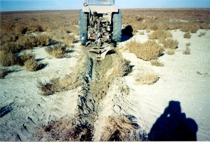
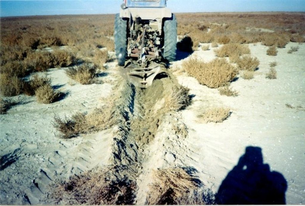
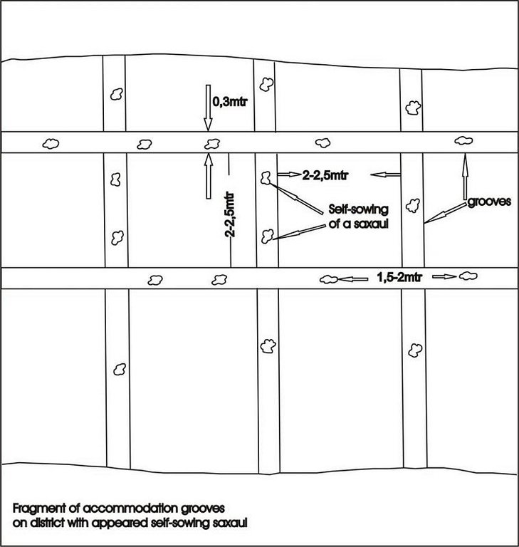
Planting of the saplings on the lots of the dried seabed of the Aral Sea was done in holes and uninterrupted furrows, which were formed by hands or cultivated KON – 2.8 PM . Depth of holes and furrows is 20-25 cm. Distance between holes was 1.5-2 m. Furrows were perpendicular to the prevailing winds (west-east) and placing mould in several options: 1 – moulds on both sides; 2 – the same from the southern side of a furrow; 3 – the same from the northern side. Furrows alternated with holes rows. Length of rows variants in repetition was 100 m. Saplings were filled up by hands or in rows in 1-2 meters, distance between rows was 2-2.5 meters. For the last 30 years Aral Sea level is falling and in 2001 it fell by 20 meters. More over 35 thousands sq. km of sea bottom came to the surface. Pace of falling during the last ten years is 0.9-0.8 meters per year according to the instrumental observations, that’s why area of dry land increases by 3-4 thousand sq. km annually.
Formation of moving sand dunes with the height of 2-5 meters, which move at the speed 20-30 meters per year in the southern and south-eastern direction, occurs on the area of more over 10 thousand sq. km. Width of dune ridges and ranges achieves 10-15 km and length up to 40-60 km. Ecosystems of brackish waste grounds lacking flora, difficult to traverse and dangerous were formed non the area 20 thousand sq. km of the former sea bottom. They are the source of dust-salt material to the major oasis agriculture in the delta of Syrdaria River.
2.3 صور التقنية
2.5 البلد/المنطقة/المواقع التي تم تنفيذ التقنية فيها والتي يغطيها هذا التقييم
البلد:
كازاخستان
المنطقة/الولاية/المحافظة:
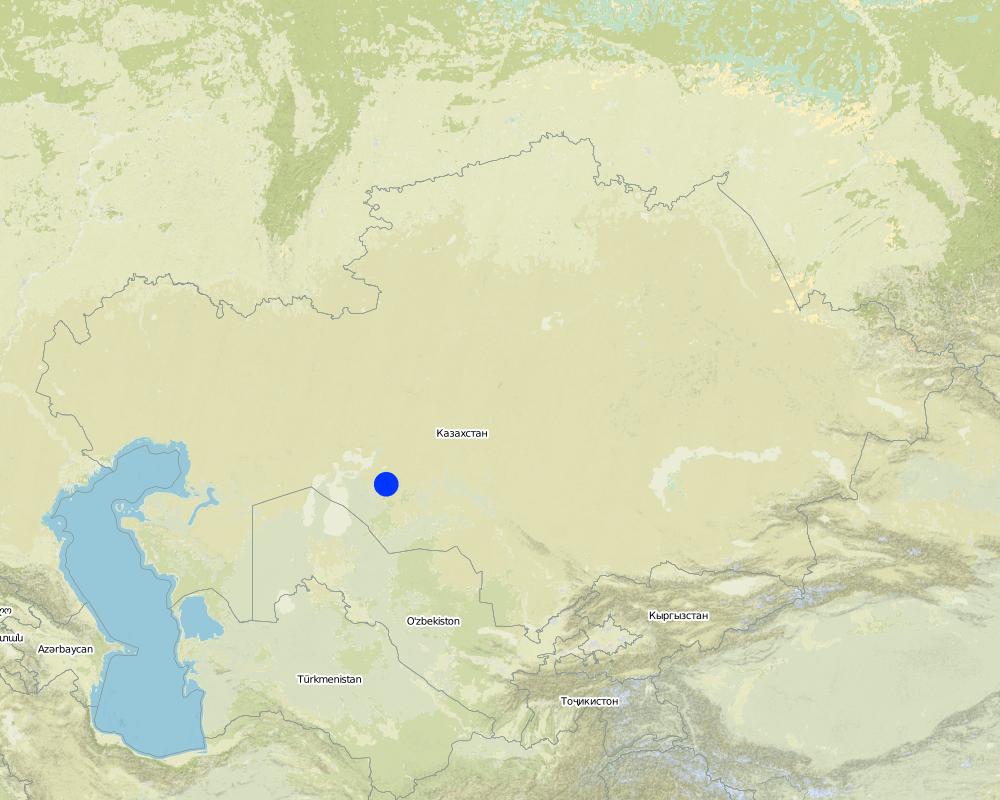
Kyzylorda
مزيد من التفاصيل حول الموقع:
Kazalinsk state
Map
×2.6 تاريخ التنفيذ
في حالة عدم معرفة السنة بالتحديد، يرجى الإشارة إلى التاريخ التقريبي:
- منذ أقل من 10 سنوات (مؤخرًا)
2.7 إدخال التقنية
حدد كيف تم إدخال التقنية:
- أثناء التجارب/الأبحاث
التعليقات (نوع المشروع، الخ):
Was developed by kazakh - investigation institute of forest facility (1996-2001)
3. تصنيف تقنية الإدارة المستدامي للأراضي
3.1 الغرض الرئيسي ( الأغراض الرئيسية) للتقنية
- الحد من تدهور الأراضي ومنعه وعكسه
- الحفاظ على النظام البيئي
3.2 نوع (أنواع) استخدام الأراضي الحالية حيث يتم تطبيق التقنية

الأراضي الزراعية
- زراعة الأشجار والشجيرات
المحاصيل الرئيسية (المحاصيل النقدية والغذائية):
major cash crop: Wood for fuel and agroforestmeliorative

أراضي الرعي
أراضي الرعي الواسع النطاق:
- الرعي المرتحل
الأنواع والمنتجات الحيوانية الرئيسية:
half nomadism
التعليقات:
Major land use problems (compiler’s opinion): exudative salinization, forming of the salty ring on the surface, lov percent of natural overgroving.
Major land use problems (land users’ perception): rarely distribution of the bush-trees and presence of bared heathlands, which makes territory useful for land-use.
Grazingland comments: private sector of peasanting and farming predominate
Clear felling of (semi-)natural forests: stocking up for fuel, every year
Problems / comments regarding forest use: Degradation of saxaul and tugay forests in result of desertification processes: subsoil waters level reduction, deflation, poverty of population. Constant reorganization of forest facilities.
Forest products and services: fuelwood, grazing / browsing, nature conservation / protection
Type of grazing system comments: private sector of peasanting and farming predominate
Constraints of infrastructure network (roads, railways, pipe lines, power lines)
Constraints of wastelands / deserts / glaciers / swamps
3.3 مزيد من المعلومات حول استخدام الأراضي
إمدادات المياه للأرض التي يتم تنفيذ التقنية عليها:
- بعلية
عدد مواسم الزراعة في السنة:
- 1
حدد:
Longest growing period in days: 208; Longest growing period from month to month: Apr - Oct
3.4 مجموعةالإدارة المستدامة للأراضي التي تنتمي إليها هذه التقنية
- تحسين الغطاء الأرضي/النباتي
- الحد من مخاطر الكوارث بالاستناد على النظام البيئي
3.5 انتشار التقنية
حدد انتشار التقنية:
- منتشرة بالتساوي على مساحة
إذا كانت التقنية منتشرة بالتساوي على منطقة ما، فحدد المنطقة التقريبية المغطاة:
- 10-1 كم2
التعليقات:
Total area covered by the SLM Technology is 4 m2.
only 2% from 35000 sq.km of Aral sea's drained bottom
3.6 التدابير التقنية في مجال إلادارة المستدامة للأراضي

التدابير الزراعية
- A1: الغطاء النباتي/التربة
- A4: المعالجة تحت السطحية

التدابير البنيوية
التعليقات:
Secondary measures: structural measures
Type of agronomic measures: cover cropping, breaking compacted topsoil
Type of vegetative measures: aligned: -against wind
3.7 الأنواع الرئيسية من تدهور الأراضي التي تناولتها التقنية

تآكل التربة الناتج عن الرياح
- (Et): فقدان التربة السطحية
التعليقات:
Main type of degradation addressed: Et: loss of topsoil
Main causes of degradation: other human induced causes (specify) (agricultural causes - Excessive water-fence on an irrigation from the rivers Syrdarya and Amurdarya.)
Secondary causes of degradation: deforestation / removal of natural vegetation (incl. forest fires), other natural causes (avalanches, volcanic eruptions, mud flows, highly susceptible natural resources, extreme topography, etc.) specify (High wind activity in region (prevalence of winds with a speed up to 5 min/sec).)
3.8 منع أو حد أو عكس تدهور الأراضي
تحديد هدف التقنية فيما يتعلق بتدهور الأراضي:
- الحد من تدهور الأراضي
4. المواصفات الفنية، وأنشطة التنفيذ، والمدخلات، والتكاليف
4.1 الرسم الفني للتقنية
4.2 المواصفات الفنية/شروحات الرسم الفني
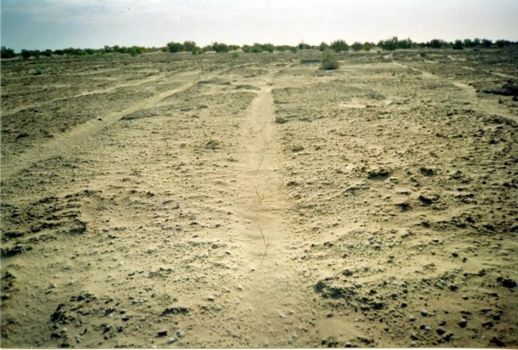
Fragment of accommodation grooves on district with appeared self-sowing saxaul
Technical knowledge required for field staff / advisors: low
Technical knowledge required for land users: low
Main technical functions: improvement of ground cover, increase of surface roughness, increase in organic matter, increase / maintain water stored in soil, sediment retention / trapping, sediment harvesting, improvement of soil structure
Cover cropping
Material/ species: saxsaul
Quantity/ density: 150
Remarks: protective planting
Breaking compacted topsoil
Remarks: breaking salturing up before planting by layout
Aligned: -against wind
Vegetative material: T : trees / shrubs
Number of plants per (ha): 150
Vertical interval between rows / strips / blocks (m): 1
Vertical interval within rows / strips / blocks (m): 1,5-2,0
Width within rows / strips / blocks (m): 30-35
Trees/ shrubs species: saxsaul, combseller
Structural measure: sediment sand / trap
Vertical interval between structures (m): 3
Spacing between structures (m): 2
Depth of ditches/pits/dams (m): 0,5
Width of ditches/pits/dams (m): 0,7
Length of ditches/pits/dams (m): 0,7
Height of bunds/banks/others (m): 0,5
Width of bunds/banks/others (m): 0,7
Length of bunds/banks/others (m): 100
Construction material (earth): fine-grained sand
Construction material (wood): saxsaul
4.3 معلومات عامة بخصوص حساب المدخلات والتكاليف
حدد العملة المستخدمة لحساب التكاليف:
- دولار أمريكي
اذكر متوسط تكلفة أجر العمالة المستأجرة في اليوم الواحد:
15.00
4.4 أنشطة التأسيس
| النشاط | نوع التدبير | التوقيت | |
|---|---|---|---|
| 1. | groove cutting | نباتية | summer |
| 2. | slips planting | نباتية | spring, autumn |
| 3. | groove cutting | بنيوية أو هيكلية | summer |
| 4. | creating traps for sand | بنيوية أو هيكلية | after planting |
4.5 التكاليف والمدخلات اللازمة للتأسيس
| تحديد المدخلات | الوحدة | الكمية | التكاليف لكل وحدة | إجمالي التكاليف لكل مدخل | % من التكاليف التي يتحملها مستخدمو الأراضي | |
|---|---|---|---|---|---|---|
| العمالة | Traps for sand, cutting and planting | persons/day | 3,0 | 15,0 | 45,0 | 66,0 |
| معدات | Others | ha | 1,0 | 20,0 | 20,0 | 29,0 |
| المواد النباتية | Others | ha | 1,0 | 125,0 | 125,0 | 83,0 |
| إجمالي تكاليف إنشاء التقنية | 190,0 | |||||
التعليقات:
Duration of establishment phase: 12 month(s)
4.6 الصيانة/الأنشطة المتكررة
| النشاط | نوع التدبير | التوقيت/الوتيرة | |
|---|---|---|---|
| 1. | groove cutting | زراعية | spring, autumn / every year |
| 2. | slips planting | زراعية | spring, autumn / every year |
4.7 التكاليف والمدخلات اللازمة للصيانة/للأنشطة المتكررة (سنويًا)
التعليقات:
saxsaul planting in the 100m * 100m. Sized beared heathlands due to enclosed SWC circuit
4.8 أهم العوامل المؤثرة على التكاليف
قدم وصفا لأهم العوامل التي تؤثر على التكاليف:
transportation of technique to the work place and gooves cutting
5. البيئة الطبيعية والبشرية
5.1 المناخ
هطول الأمطار السنوي
- < 250 مم
- 251- 500 ملم
- 501 - 750ملم
- 1,000-751 ملم
- 1,500-1,100 ملم
- 2,000-1,500 ملم
- 3,000-2,001 ملم
- 4,000-3,100 ملم
- > 4000 ملم
المواصفات/التعليقات على هطول الأمطار:
Average long-termed rainfall quantity makes 124 mm per year
المنطقة المناخية الزراعية
- قاحلة
Arid deserted
5.2 طوبوغرافيا
متوسط الانحدارات:
- مسطح (0-2%)
- بسيط (3-5%)
- معتدل (6-10%)
- متدحرج (11-15%)
- تلال (16-30%)
- شديدة الانحدار(31-60%)
- فائقة الانحدار (>60%)
التضاريس:
- هضاب/سهول
- أثلام مرتفعة
- المنحدرات الجبلية
- منحدرات التلال
- منحدرات في السفوح
- قاع الوادي
المنطقة الارتفاعية:
- 100-0 متر فوق سطح البحر
- 500-101 متر فوق سطح البحر
- 1,000-501 متر فوق سطح البحر
- 1,500-1,001 متر فوق سطح البحر
- 2,000-1,501 متر فوق سطح البحر
- 2,500-2,100 متر فوق سطح البحر
- 3,000-2,501 متر فوق سطح البحر
- 4,000-3,001 متر فوق سطح البحر
- > 4000 متر فوق سطح البحر
التعليقات والمواصفات الإضافية بشأن التضاريس:
Landforms: Weak inclined primary -sea plain
Landforms: It is complicated with accumulative forms of colian relief
Altitudinal zone: 36 - 51 m a.s.l.
5.3 التربة
متوسط عمق التربة:
- ضحل جدًا (0-20 سم)
- ضحلة (21-50 سم)
- متوسطة العمق (51-80 سم)
- عميقة (81-120 سم)
- عميقة جدًا (> 120 سم)
قوام التربة (التربة السطحية):
- خشن / خفيف (رملي)
- متوسط ( طميي، سلتي)
المواد العضوية في التربة السطحية:
- منخفضة (<1%)
إذا كان متاحًا، قم بإرفاق وصف كامل للتربة أو تحديد المعلومات المتوفرة، على سبيل المثال نوع التربة، الرقم الهيدروجيني/ درجة حموضة التربة، قدرة التبادل الكاتيوني، النيتروجين، الملوحة وما إلى ذلك.
Soil depth on average: Soils were not formed yet, horizons are absent
Topsoil organic matter: 0,19%-0,24%
Soil fertility is low with 0,24% of humus
Soil drainage / infiltration is poor in suclay, medium for clay and good loam-sandy and sandy soils
Soil water storage capacity is low - very low
5.6 خصائص مستخدمي الأراضي الذين يطبقون التقنية
التوجه السوقي لنظام الإنتاج:
- مختلط (كفاف/ تجاري)
الدخل من خارج المزرعة:
- أقل من % 10من كامل الدخل
المستوى النسبي للثروة:
- ضعيف جدا
- ضعيف
مستوى المكننة:
- عمل يدوي
- ميكانيكية/ مزودة بمحرك
اذكر الخصائص الأخرى ذات الصلة لمستخدمي الأراضي:
Population density: < 10 persons/km2
Annual population growth: negative
10% of the land users are average wealthy and own 60% of the land.
30% of the land users are poor and own 20% of the land.
60% of the land users are poor and own 20% of the land.
Off-farm income specification: catche fish grow vegetable - melon cultures and realizate them
Market orientation of production system: Firewood stocking and raise of forage capasity.
Level of mechanization: Using shovel for manual labour and tractor MTZ-30 for mechanised labour.
5.7 متوسط مساحة الأرض المملوكة أو المستأجرة من قبل مستخدمي الأراضي الذين يطبقون التقنية
- < 0.5 هكتارا
- 0.5 - 1 هكتار
- 1 -2 هكتار
- 2 - 5 هكتار
- 5 - 15 هكتار
- 15 - 50 هكتار
- 50 - 100هكتار
- 500-100 هكتار
- 1,000-500 هكتار
- 10,000-1,000 هكتار
- > 10,000 هكتار
التعليقات:
Also 2-5 ha
5.8 ملكية الأراضي، وحقوق استخدام الأراضي، وحقوق استخدام المياه
ملكية الارض:
- دولة
حقوق استخدام الأراضي:
- مجتمعي (منظم)
- فردي
6. الآثار والتصريحات الختامية
6.1 الآثار التي أظهرتها التقنية في الموقع
الآثار الاجتماعية والاقتصادية
الإنتاج
إنتاج الأعلاف
التعليقات/ حدد:
In adverse years
جودة العلف
التعليقات/ حدد:
In adverse years
الدخل والتكاليف
دخل المزرعة
التعليقات/ حدد:
Exspenses for fuel decrease
آثار اجتماعية واقتصادية أخرى
employment at farm
التعليقات/ حدد:
Production increase
groove cuting tools
التعليقات/ حدد:
High rent payment for technique
الآثار الاجتماعية والثقافية
المؤسسات المجتمعية
التعليقات/ حدد:
Population's employment
المعرفة بالإدارة المستدامة للأراضي/تدهور الأراضي
التعليقات/ حدد:
Ecological education
educational and cultural level of former members
التعليقات/ حدد:
Native population's not understanding benefits of using SWC
الآثار الايكولوجية
دورة المياه / الجريان السطحي
تصريف المياه الزائدة
التعليقات/ حدد:
Humus accumulation
التربة
غطاء التربة
التعليقات/ حدد:
Salt removal of top horizons
فقدان التربة
الكمية قبل الإدارة المستدامة للأراضي:
30
الكمية بعد الإدارة المستدامة للأراضي:
10
التعليقات/ حدد:
Increase of kinds structure
الآثار الايكولوجية الأخرى
biodiversity
التعليقات/ حدد:
Activity of wind stream decrease
soil fertility
التعليقات/ حدد:
Avoidance of blowing
fuel supply
التعليقات/ حدد:
4-5 hectare per year
6.2 الآثار التي أظهرتها التقنية خارج الموقع
الرواسب المنقولة بواسطة الرياح
التعليقات/ حدد:
Soil surface's erosion stop's
6.4 تحليل التكلفة والعائد
كيف يمكن مقارنة العوائد نسبة لتكاليف الإنشاء (من وجهة نظر مستخدمي الأراضي)؟
عوائد طويلة الأجل:
إيجابي قليلا
كيف تتم مقارنة العوائدمع كلفة الصيانة/التكاليف المتكررة (من وجهة نظر مستخدمي الأراضي)؟
عوائد طويلة الأجل:
إيجابي قليلا
6.5 اعتماد التقنية
- 1-10%
إذا كان متاحًا، قم بتحديد الكمية (عدد الأسر المعيشية و/أو المساحةالمغطاة):
13 households covering 1 percent of stated area
من بين جميع الذين تبنوا التقنية، كم عدد الذين فعلوا ذلك بشكل تلقائي، أي دون تلقي أي حوافز مادية/مدفوعات؟:
- 50-10%
التعليقات:
10 land user families have adopted the Technology with external material support
Comments on acceptance with external material support: survey results
3 land user families have adopted the Technology without any external material support
Comments on spontaneous adoption: survey results
There is a little trend towards spontaneous adoption of the Technology
Comments on adoption trend: small farmer's economical vell-being improves
6.7 نقاط القوة / المزايا / الفرص التي توفرها التقنية
| نقاط القوة/ المزايا/ الفرص من وجهة نظر مستخدمي الأراضي |
|---|
|
forest territory are restoring How can they be sustained / enhanced? during saxaul communities life |
|
soil deflation's speed and temps decrease How can they be sustained / enhanced? during saxaul communities life |
|
microclimate conditions increase How can they be sustained / enhanced? during saxaul communities life |
| نقاط القوة/ المزايا/ الفرص من وجهة نظر جامع المعلومات أو غيره من الاشخاص الرئيسيين لمصدر المعلومات |
|---|
|
forests area and output of fuel increase How can they be sustained / enhanced? during saxauls plantings life (40-50) years |
|
field-dust carrying out is prevented How can they be sustained / enhanced? during communities vitual activity |
|
environmental and sanitary-epidemiological contitions improves How can they be sustained / enhanced? during technology SWC existence |
|
Additional work places are created How can they be sustained / enhanced? in period technology SWC application |
6.8 نقاط ضعف / مساوىء / مخاطر التقنية وسبل التغلب عليها
| نقاط الضعف/ المساوىء/ المخاطر من وجهة نظر مستخدم الأراضي | كيف يمكن التغلب عليها؟ |
|---|---|
| absence of enough qvantity of enough quantity of technique | by means of cooperative association of facilities |
| نقاط الضعف/ المساوىء/ المخاطر من وجهة نظر جامع المعلومات أو غيره من الاشخاص الرئيسيين لمصدر المعلومات | كيف يمكن التغلب عليها؟ |
|---|---|
| high rent payment for technique | additional purchase of the mechanised means |
| Low interest of local social institutions | to pay big attention for ecological education |
7. المراجع والروابط
7.2 المراجع للمنشورات المتاحة
العنوان، المؤلف، السنة، النظام القياسي الدولي لترقيم الكتب ISBN:
"to study process of overgroving and to develop offers on assistance to natural reneval of saxaul black on the grounds of Aral Sea's naked bottom"
متاح من أين؟كم التكلفة؟:
RGP,SPC of forest facility. Kirov str.,58 city Schuchinsk, Akmola region
الروابط والوحدات المواضيعية
توسيع الكل طي الكلالروابط
لا يوجد روابط
الوحدات المواضيعية
لا يوجد وحدات مواضيعية


