Farm pond [الهند]
- تاريخ الإنشاء:
- تحديث:
- جامع المعلومات: Channabasappa Metri
- المحرر: –
- المُراجع: Fabian Ottiger
krushi honda (Kannada)
technologies_1474 - الهند
عرض الأقسام
توسيع الكل طي الكل1. معلومات عامة
1.2 تفاصيل الاتصال بالأشخاص الرئيسيين لمصدر المعلومات والمؤسسات المشاركة في تقييم وتوثيق التقنية
متخصص في الإدارة المستدامة للأراضي:
Benson Roland
08352 276586
Danida KWDP Bijapur
Bijapur
الهند
متخصص في الإدارة المستدامة للأراضي:
Mujibur Rahman Syed
08352 276586
Danida KWDP Bijapur
Bijapur
الهند
متخصص في الإدارة المستدامة للأراضي:
Thippeswamaiah
08352 276586
KWDP Daida Bijapur
Bijapur
الهند
اسم المؤسسة (المؤسسات) التي سهلت توثيق/تقييم التقنية (إذا كان ذلك على صلة)
Danida assisted Karnataka Watershed Development Project, Bijapur (Danida assisted Karnataka Watershed Development Project, Bijapur) - الهند1.3 الشروط المتعلقة باستخدام البيانات الموثقة من خلال WOCAT
متى تم تجميع البيانات (ميدانيا)؟:
16/02/2004
يوافق جامع المعلومات والشخص (لاشخاص) الرئيسي لمصدر المعلومات على الشروط المتعلقة باستخدام البيانات الموثقة من خلال WOCAT:
نعم
1.5 الإشارة إلى الاستبيان (الاستبيانات) حول مناهج الإدارة المستدامة للأراضي
Stakeholders participation in the project activities [الهند]
SWC approach is a participatory methodology to empower the community to plan, implement, monitor, evaluate and manage the SWC technology to bring about sustainability
- جامع المعلومات: Pranesh Jahagirdar
2. وصف تقنيةالإدارة المستدامي للأراضي
2.1 وصف مختصر للتقنية
تعريف التقنية:
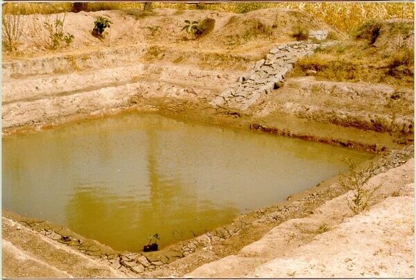
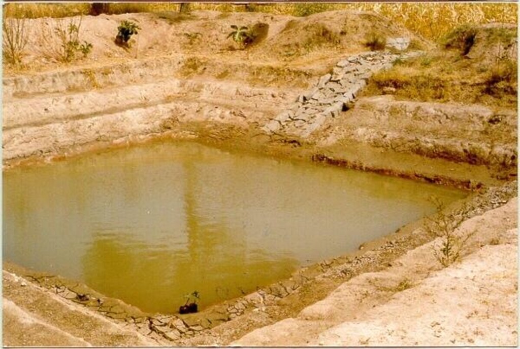
A sunken structure (12 x 12 x 3 m, more suiable), constructed by escavation in arable land with a view of temporary runoff storage tapped for protective irrigation, and to increase percolation for recharge of ground water (to convert surface to subsurface flow)
2.2 وصف تفصيلي للتقنية
الوصف:
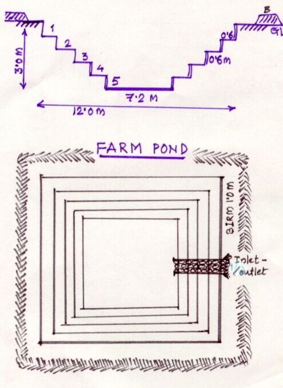
A farm pond comprises of excavated portions of 12 x 12 x 3 m with the steps at 0.6m depth each. The excavated earth is deposited all around the structure as a bund, with a burm space of 1m. An inlet cum outlet provided in the course of flow of rain water to collect and dispose the excess runoff.
Purpose of the Technology: (1). For storage of exess runoff. (2) to increase percolation for ground water recharge, (3). To use for protective irrigation during dry period, (4). To stop further deepening of watercourse in arable lands
Establishment / maintenance activities and inputs: Selection of beneficiary is by the community and site selection, Design/ layout and excavation by the project staff with participation of the beneficiary. Desilting of the structure is by the beneficiary
Natural / human environment: surrounding lands are more slopy and with exposed rocks, most of the surrounding area is left for grazing
2.3 صور التقنية
2.5 البلد/المنطقة/المواقع التي تم تنفيذ التقنية فيها والتي يغطيها هذا التقييم
البلد:
الهند
المنطقة/الولاية/المحافظة:
Karnataka
مزيد من التفاصيل حول الموقع:
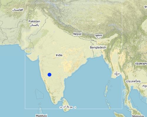
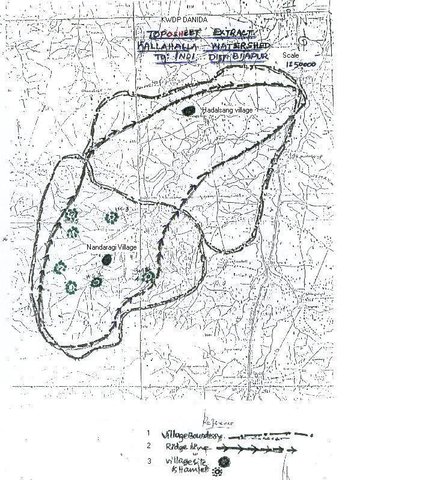
Bijapur district, Hadalsang village
Map
×2.6 تاريخ التنفيذ
في حالة عدم معرفة السنة بالتحديد، يرجى الإشارة إلى التاريخ التقريبي:
- منذ أقل من 10 سنوات (مؤخرًا)
2.7 إدخال التقنية
حدد كيف تم إدخال التقنية:
- من خلال المشاريع/ التدخلات الخارجية
التعليقات (نوع المشروع، الخ):
Department of Agriculture, Govet. Of Karnataka
3. تصنيف تقنية الإدارة المستدامي للأراضي
3.1 الغرض الرئيسي ( الأغراض الرئيسية) للتقنية
- تحسين الإنتاج
- الحفاظ على النظام البيئي
- التكيف مع تغير المناخ/الظواهر المتطرفة وآثارها
3.2 نوع (أنواع) استخدام الأراضي الحالية حيث يتم تطبيق التقنية

الأراضي الزراعية
- زراعة سنوية
المحاصيل الرئيسية (المحاصيل النقدية والغذائية):
Major cash crop: Chilli
Major food crop: Jowar
Major other crops: Brinjal, castor, lady's finger
التعليقات:
Major land use problems (compiler’s opinion): The lands are very undulating (Class-V as per the Land Capability Classification), with very shallow soils, feasible for only one rainfed crops.
Major land use problems (land users’ perception): Poor yields due to shallow soils that too only one crop in one season, undulating lands leading to more runoff.
Type of cropping system and major crops comments: minor pulses - cereals (green gram-jowar)
Constraints of wastelands / deserts / glaciers / swamps: Highly eroded, unsuitable for any production purposes.
3.3 مزيد من المعلومات حول استخدام الأراضي
إمدادات المياه للأرض التي يتم تنفيذ التقنية عليها:
- بعلية
التعليقات:
Water supply: Also mixed rainfed - irrigated (ranked 2)
عدد مواسم الزراعة في السنة:
- 2
حدد:
Longest growing period in days: 120 Longest growing period from month to month: Sep - Dec Second longest growing period in days: 90 Second longest growing period from month to month: Jul - Sep
3.4 مجموعةالإدارة المستدامة للأراضي التي تنتمي إليها هذه التقنية
- حصاد المياه
- إدارة الري (بما في ذلك إمدادات المياه والصرف الصحي)
3.5 انتشار التقنية
حدد انتشار التقنية:
- منتشرة بالتساوي على مساحة
إذا كانت التقنية منتشرة بالتساوي على منطقة ما، فحدد المنطقة التقريبية المغطاة:
- < 0.1 كم2 (10 هكتار)
التعليقات:
Total area covered by the SLM Technology is 3 m2.
The technology area comprising of 2.8 ha within the overall watershed area of 2458 ha. The technology is useful in harvesting the excess rainwater in the arable land and re-use the for protective irigation after the rainy period.
3.6 التدابير التقنية في مجال إلادارة المستدامة للأراضي
3.7 الأنواع الرئيسية من تدهور الأراضي التي تناولتها التقنية

تآكل التربة بالمياه
- الوزن(Wt): فقدان التربة السطحية/تآكل السطح
- (Wg):الانجراف الخلجاني/ الخلجان
- (Wo:) تأثيرات التدهور من مواقع أخرى
التعليقات:
Main type of degradation addressed: Wt: loss of topsoil / surface erosion
Secondary types of degradation addressed: Wg: gully erosion / gullying, Wo: offsite degradation effects
Main causes of degradation: other natural causes (avalanches, volcanic eruptions, mud flows, highly susceptible natural resources, extreme topography, etc.) specify, poverty / wealth (lack of captial)
Secondary causes of degradation: other human induced causes (specify) (other (migration)), labour availability (lack of labour, cost of labour), education, access to knowledge and support services (lack of knowledge)
3.8 منع أو حد أو عكس تدهور الأراضي
تحديد هدف التقنية فيما يتعلق بتدهور الأراضي:
- منع تدهور الأراضي
- الحد من تدهور الأراضي
التعليقات:
Main goals: mitigation / reduction of land degradation
Secondary goals: prevention of land degradation
4. المواصفات الفنية، وأنشطة التنفيذ، والمدخلات، والتكاليف
4.1 الرسم الفني للتقنية
4.2 المواصفات الفنية/شروحات الرسم الفني
The drawing showing the details of the farm pond. 12 x 12 x 3 m dimension. Five steps cutting on each side with 1:1 side slope. 1m birm (space) between the earthen bund. 1m wide spilway inlet cum outlet at suitable place of the site.
Location: Kallahalla nala watershed, Indi Taluk. Bijapur district of Karnataka state
Date: 20.4.2004
Technical knowledge required for field staff / advisors: moderate
Technical knowledge required for land users: high
Main technical functions: water harvesting / increase water supply
Secondary technical functions: increase of infiltration, increase / maintain water stored in soil
Structural measure: sediment sand / trap
Depth of ditches/pits/dams (m): 3
Width of ditches/pits/dams (m): 15
Length of ditches/pits/dams (m): 15
Height of bunds/banks/others (m): 1
Width of bunds/banks/others (m): 1
Length of bunds/banks/others (m): 15
Construction material (earth): soil excavated from the pond is used to for bunds all around the structure with 1 m birm space.
Construction material (stone): The spillway Inlet cum Outlet is constructed using stones
For water harvesting: the ratio between the area where the harvested water is applied and the total area from which water is collected is: 1:7
Vegetation is used for stabilisation of structures.
4.3 معلومات عامة بخصوص حساب المدخلات والتكاليف
عملة أخرى/ عملة وطنية (حدد):
Ruppes
أشر إلى سعر الصرف من الدولار الأمريكي إلى العملة المحلية (إذا كان ذا صلة): 1 دولار أمريكي =:
46,0
اذكر متوسط تكلفة أجر العمالة المستأجرة في اليوم الواحد:
0.73
4.4 أنشطة التأسيس
| النشاط | نوع التدبير | التوقيت | |
|---|---|---|---|
| 1. | selection of site and survey, preparation of estimates | بنيوية أو هيكلية | summer |
| 2. | submission for sanction of approval | بنيوية أو هيكلية | summer |
| 3. | Excavation of the farmpond | بنيوية أو هيكلية | summer |
| 4. | construction of inlet/ outlet | بنيوية أو هيكلية | before monsoon starts |
4.5 التكاليف والمدخلات اللازمة للتأسيس
| تحديد المدخلات | الوحدة | الكمية | التكاليف لكل وحدة | إجمالي التكاليف لكل مدخل | % من التكاليف التي يتحملها مستخدمو الأراضي | |
|---|---|---|---|---|---|---|
| العمالة | Labour | ha | 1,0 | 360,0 | 360,0 | 10,0 |
| مواد البناء | Stone | ha | 1,0 | 109,43 | 109,43 | 100,0 |
| إجمالي تكاليف إنشاء التقنية | 469,43 | |||||
التعليقات:
Duration of establishment phase: 0 month(s)
4.6 الصيانة/الأنشطة المتكررة
| النشاط | نوع التدبير | التوقيت/الوتيرة | |
|---|---|---|---|
| 1. | Meeting with the farmer | بنيوية أو هيكلية | monsoon/annual |
| 2. | Desilting of farmpond | بنيوية أو هيكلية | summer season/once in 2 years |
| 3. | Repair of Inlet/Outlet | بنيوية أو هيكلية | summer season/Every year |
| 4. | Trimming of Bund | بنيوية أو هيكلية | summer season/Every year |
4.7 التكاليف والمدخلات اللازمة للصيانة/للأنشطة المتكررة (سنويًا)
| تحديد المدخلات | الوحدة | الكمية | التكاليف لكل وحدة | إجمالي التكاليف لكل مدخل | % من التكاليف التي يتحملها مستخدمو الأراضي | |
|---|---|---|---|---|---|---|
| العمالة | Labour | ha | 1,0 | 7,3 | 7,3 | 100,0 |
| إجمالي تكاليف صيانة التقنية | 7,3 | |||||
التعليقات:
12 m x 12 m x 3 m size with all side slope of 1:1 (five steps of 0.6 m deep), Inlet cum outlet spilway constructed with stones. This indicates only the actual cost of construction. (excavation / earth wotk and stone work for inlet/outlet)
4.8 أهم العوامل المؤثرة على التكاليف
قدم وصفا لأهم العوامل التي تؤثر على التكاليف:
If the implementation site is having the hard strata, then the cost will be more.
5. البيئة الطبيعية والبشرية
5.1 المناخ
هطول الأمطار السنوي
- < 250 مم
- 251- 500 ملم
- 501 - 750ملم
- 1,000-751 ملم
- 1,500-1,100 ملم
- 2,000-1,500 ملم
- 3,000-2,001 ملم
- 4,000-3,100 ملم
- > 4000 ملم
حدد متوسط هطول الأمطار السنوي (إذا كان معروفًا)، بالملليمتر:
550,00
المنطقة المناخية الزراعية
- شبه قاحلة
Located on the latitude 16-49'N and longitude 75-43'E .Characterised by hot dry summer (42 °C) and cold dry winters monsoon (July-September) is characterised by high intensity showers followed by pro
5.2 طوبوغرافيا
متوسط الانحدارات:
- مسطح (0-2%)
- بسيط (3-5%)
- معتدل (6-10%)
- متدحرج (11-15%)
- تلال (16-30%)
- شديدة الانحدار(31-60%)
- فائقة الانحدار (>60%)
التضاريس:
- هضاب/سهول
- أثلام مرتفعة
- المنحدرات الجبلية
- منحدرات التلال
- منحدرات في السفوح
- قاع الوادي
المنطقة الارتفاعية:
- 100-0 متر فوق سطح البحر
- 500-101 متر فوق سطح البحر
- 1,000-501 متر فوق سطح البحر
- 1,500-1,001 متر فوق سطح البحر
- 2,000-1,501 متر فوق سطح البحر
- 2,500-2,100 متر فوق سطح البحر
- 3,000-2,501 متر فوق سطح البحر
- 4,000-3,001 متر فوق سطح البحر
- > 4000 متر فوق سطح البحر
التعليقات والمواصفات الإضافية بشأن التضاريس:
Altitudinal zone: 501-1000 m a.s.l. (594 m a.s.l.)
Slopes on average: Gentle (ridge and valley portion)
5.3 التربة
متوسط عمق التربة:
- ضحل جدًا (0-20 سم)
- ضحلة (21-50 سم)
- متوسطة العمق (51-80 سم)
- عميقة (81-120 سم)
- عميقة جدًا (> 120 سم)
قوام التربة (التربة السطحية):
- متوسط ( طميي، سلتي)
المواد العضوية في التربة السطحية:
- منخفضة (<1%)
إذا كان متاحًا، قم بإرفاق وصف كامل للتربة أو تحديد المعلومات المتوفرة، على سبيل المثال نوع التربة، الرقم الهيدروجيني/ درجة حموضة التربة، قدرة التبادل الكاتيوني، النيتروجين، الملوحة وما إلى ذلك.
Soil depth on average: Shallow (30 cm)
Soil texture: Medium (medium in valley portion)
Soil fertility: Low (along the slope of the ridge, ranked 1) and medium (valley portion, ranked 2)
Topsoil organic matter: Low (in valley portion)
Soil water storage capacity: Low (hill portion, ranked 1) and medium (valley portion, ranked 2)
5.6 خصائص مستخدمي الأراضي الذين يطبقون التقنية
التوجه السوقي لنظام الإنتاج:
- مختلط (كفاف/ تجاري)
الدخل من خارج المزرعة:
- 10-50% من جميع الإيرادات
المستوى النسبي للثروة:
- ضعيف
اذكر الخصائص الأخرى ذات الصلة لمستخدمي الأراضي:
Population density: 100-200 persons/km2
Annual population growth: 3% - 4%
15% of the land users are very rich and own 5% of the land.
25% of the land users are rich and own 20% of the land.
50% of the land users are average wealthy and own 50% of the land.
10% of the land users are poor and own 15% of the land.
and own 10% of the land.
Off-farm income specification: Through sheep and goat rearing
Level of mechanization: Animal traction, (ranked 1, for ploughing, seed sowing harrowing), manual work (ranked 2, clod crushing, harvesting, threashing) and mechanised (ranked 3, Deep ploughing, levelling)
5.7 متوسط مساحة الأرض المملوكة أو المستأجرة من قبل مستخدمي الأراضي الذين يطبقون التقنية
- < 0.5 هكتارا
- 0.5 - 1 هكتار
- 1 -2 هكتار
- 2 - 5 هكتار
- 5 - 15 هكتار
- 15 - 50 هكتار
- 50 - 100هكتار
- 500-100 هكتار
- 1,000-500 هكتار
- 10,000-1,000 هكتار
- > 10,000 هكتار
التعليقات:
Average area of land owned or leased by land users applying the Technology:
1-2 ha (ranked 1, marginal farmers [since the land holding decreases because of the fractionation the production and productivity also reduces])
2-5 ha (ranked 2, small farmers)
5-15 ha (ranked 3, big famers)
5.8 ملكية الأراضي، وحقوق استخدام الأراضي، وحقوق استخدام المياه
ملكية الارض:
- فردية، يوجد سند ملكية
حقوق استخدام الأراضي:
- فردي
6. الآثار والتصريحات الختامية
6.1 الآثار التي أظهرتها التقنية في الموقع
الآثار الاجتماعية والاقتصادية
الإنتاج
إنتاج المحاصيل
التعليقات/ حدد:
Second crop also taken
إنتاج الأعلاف
التعليقات/ حدد:
From trees
جودة العلف
التعليقات/ حدد:
From trees
تنوع المنتج
التعليقات/ حدد:
Difference in the crop like on bunds and in the patches of crops.
منطقة الإنتاج
التعليقات/ حدد:
15m x 15m land loss average land holding is very less, thus small & marginal farmers face reduction in the production area with this SWC
إدارة الأراضي
التعليقات/ حدد:
After implementing SWC less area is left for very small and marginal land holding.
توافر المياه ونوعيتها
توافر المياه للماشية
الدخل والتكاليف
دخل المزرعة
التعليقات/ حدد:
Subsistance agriculture
آثار اجتماعية واقتصادية أخرى
Input constraints
التعليقات/ حدد:
To bring new area into cultivation
الآثار الاجتماعية والثقافية
المعرفة بالإدارة المستدامة للأراضي/تدهور الأراضي
الآثار الايكولوجية
دورة المياه / الجريان السطحي
تصريف المياه الزائدة
التربة
رطوبة التربة
غطاء التربة
فقدان التربة
الآثار الايكولوجية الأخرى
Soil fertility
6.2 الآثار التي أظهرتها التقنية خارج الموقع
تدفقات مائية موثوقة ومستقرة في موسم الجفاف
الفيضان في اتجاه مجرى النهر
التعليقات/ حدد:
Water storage in farm pond
6.4 تحليل التكلفة والعائد
كيف يمكن مقارنة العوائد نسبة لتكاليف الإنشاء (من وجهة نظر مستخدمي الأراضي)؟
عوائد قصيرة الأجل:
إيجابي
عوائد طويلة الأجل:
إيجابي
كيف تتم مقارنة العوائدمع كلفة الصيانة/التكاليف المتكررة (من وجهة نظر مستخدمي الأراضي)؟
عوائد قصيرة الأجل:
إيجابي
عوائد طويلة الأجل:
إيجابي
6.5 اعتماد التقنية
التعليقات:
There is a little trend towards spontaneous adoption of the Technology
Comments on adoption trend: The community is motivated with the benefits from this SWC structure. Some of them have already deepened the farmponds to increase its storage capacity.However, since most of the farmers are having very small land holdings and there was continous dry season from last three years, even if the farmers are motivated and aware of the technology of farmpond, they could not take up on their own (without financial assistance from the project.
6.7 نقاط القوة / المزايا / الفرص التي توفرها التقنية
| نقاط القوة/ المزايا/ الفرص من وجهة نظر مستخدمي الأراضي |
|---|
|
Increased storage of water How can they be sustained / enhanced? Desilting by the farmer |
| Reduce gully formation |
|
Bring more area under irrigation How can they be sustained / enhanced? By giving life saving irrigation |
|
Economic benefits How can they be sustained / enhanced? By yields (monocropping to multiple cropping) --> more income |
|
Recycle the silt is beneficial How can they be sustained / enhanced? Other the silt would been lost every year and it is good to retain the soil fertility. |
| نقاط القوة/ المزايا/ الفرص من وجهة نظر جامع المعلومات أو غيره من الاشخاص الرئيسيين لمصدر المعلومات |
|---|
|
Storage of water How can they be sustained / enhanced? By deepening |
|
Reduced runoff velocity How can they be sustained / enhanced? By mentainance |
|
Breaching of bunds down stream How can they be sustained / enhanced? By reducing the run-off |
|
Replicability How can they be sustained / enhanced? if a famer has his own labour/ man power then he can go for its construction. |
|
Water harvesting How can they be sustained / enhanced? recycle for protective irrigation during peak season. |
6.8 نقاط ضعف / مساوىء / مخاطر التقنية وسبل التغلب عليها
| نقاط الضعف/ المساوىء/ المخاطر من وجهة نظر مستخدم الأراضي | كيف يمكن التغلب عليها؟ |
|---|---|
| Inability to contribute 100% towards cost of construction. | By giving schemes / financial assistance |
| Loosing of portion of cultivable land | By utilizing bunds, change in cropping system/ cropping pattern etc. |
| نقاط الضعف/ المساوىء/ المخاطر من وجهة نظر جامع المعلومات أو غيره من الاشخاص الرئيسيين لمصدر المعلومات | كيف يمكن التغلب عليها؟ |
|---|---|
| Difficult to excavate in hard strata | can be done in shallow soils |
| Silt accumulation, if upper catchment is not treated | Treatment of upper catchment |
7. المراجع والروابط
7.2 المراجع للمنشورات المتاحة
العنوان، المؤلف، السنة، النظام القياسي الدولي لترقيم الكتب ISBN:
Department Guidelines,Project Implementation plan, UAS Dharwad
متاح من أين؟كم التكلفة؟:
In the office, personal contact
العنوان، المؤلف، السنة، النظام القياسي الدولي لترقيم الكتب ISBN:
PIP
متاح من أين؟كم التكلفة؟:
in the office
العنوان، المؤلف، السنة، النظام القياسي الدولي لترقيم الكتب ISBN:
University of Agril. Sciences Dharwad
متاح من أين؟كم التكلفة؟:
personal contact
الروابط والوحدات المواضيعية
توسيع الكل طي الكلالروابط

Stakeholders participation in the project activities [الهند]
SWC approach is a participatory methodology to empower the community to plan, implement, monitor, evaluate and manage the SWC technology to bring about sustainability
- جامع المعلومات: Pranesh Jahagirdar
الوحدات المواضيعية
لا يوجد وحدات مواضيعية


