Gully Rehabilitation with Native Trees [طاجيكستان]
- تاريخ الإنشاء:
- تحديث:
- جامع المعلومات: Selina Studer
- المحرر: –
- المُراجع: David Streiff
technologies_1543 - طاجيكستان
عرض الأقسام
توسيع الكل طي الكل1. معلومات عامة
1.2 تفاصيل الاتصال بالأشخاص الرئيسيين لمصدر المعلومات والمؤسسات المشاركة في تقييم وتوثيق التقنية
مستخدم الأرض:
Mirsoiv Iskandar
طاجيكستان
مستخدم الأرض:
Mirsoiv Avaz
طاجيكستان
متخصص في الإدارة المستدامة للأراضي:
متخصص في الإدارة المستدامة للأراضي:
Boev Jahonbek
jahonbek.boev@mail.ru
NCCR
طاجيكستان
متخصص في الإدارة المستدامة للأراضي:
اسم المؤسسة (المؤسسات) التي سهلت توثيق/تقييم التقنية (إذا كان ذلك على صلة)
NCCR North-South (NCCR North-South) - قرغيزستاناسم المؤسسة (المؤسسات) التي سهلت توثيق/تقييم التقنية (إذا كان ذلك على صلة)
Tajik Soil Insitute (Tajik Soil Institute) - طاجيكستاناسم المؤسسة (المؤسسات) التي سهلت توثيق/تقييم التقنية (إذا كان ذلك على صلة)
CDE Centre for Development and Environment (CDE Centre for Development and Environment) - سويسرا1.3 الشروط المتعلقة باستخدام البيانات الموثقة من خلال WOCAT
متى تم تجميع البيانات (ميدانيا)؟:
17/07/2012
يوافق جامع المعلومات والشخص (لاشخاص) الرئيسي لمصدر المعلومات على الشروط المتعلقة باستخدام البيانات الموثقة من خلال WOCAT:
نعم
2. وصف تقنيةالإدارة المستدامي للأراضي
2.1 وصف مختصر للتقنية
تعريف التقنية:
Vegetative and structural technology for the rehabilitation of an expanded gully
2.2 وصف تفصيلي للتقنية
الوصف:
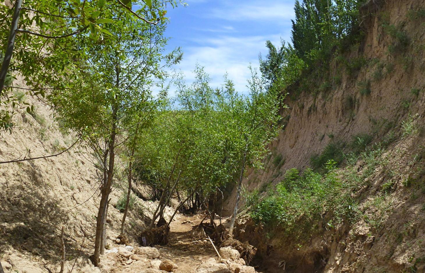
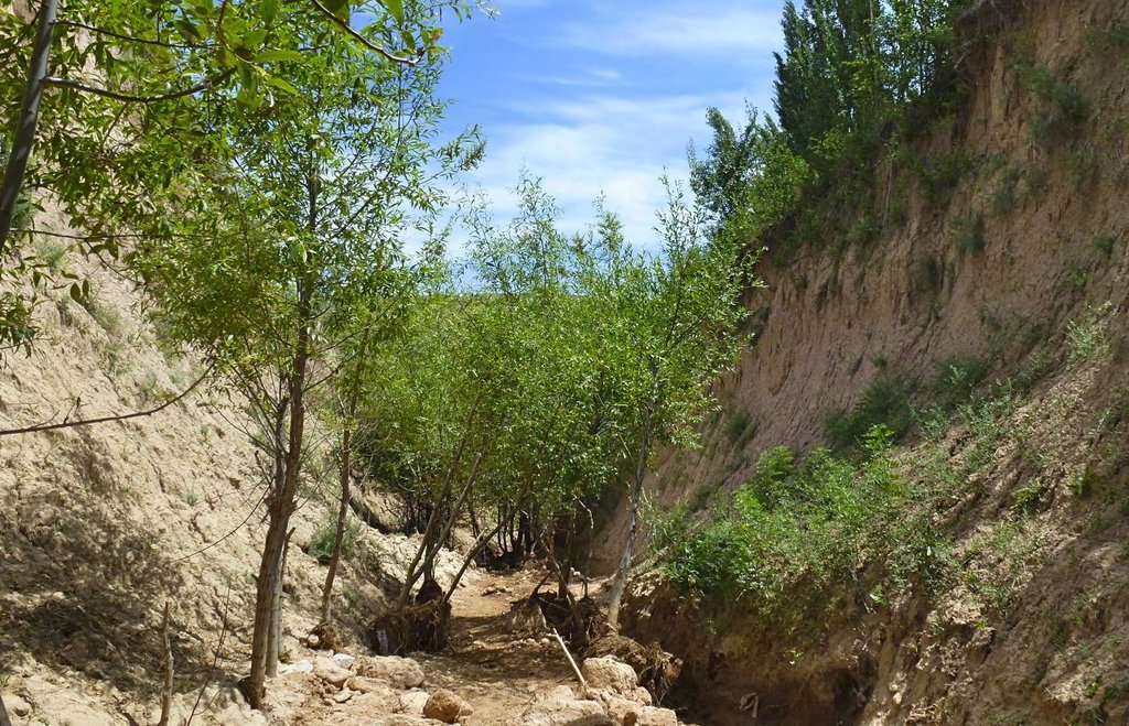
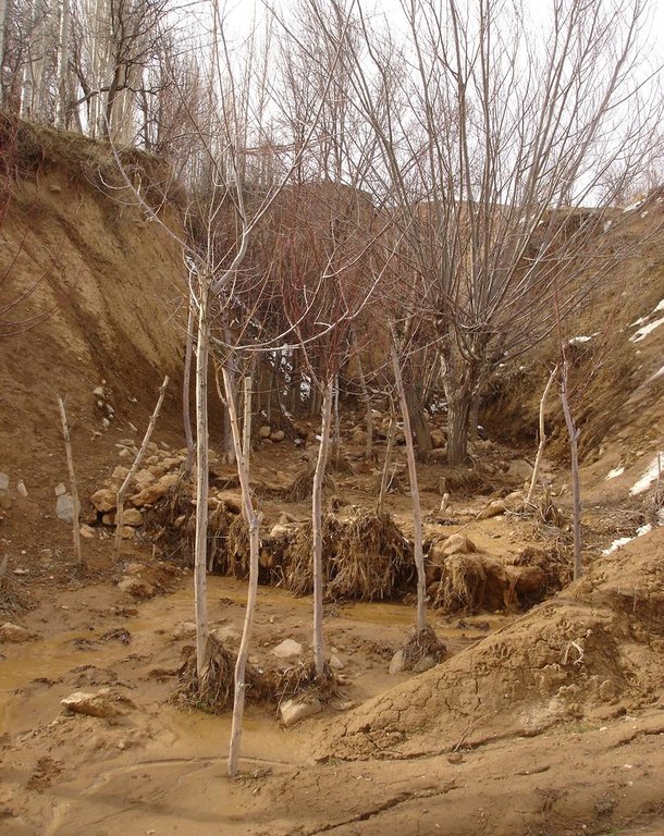
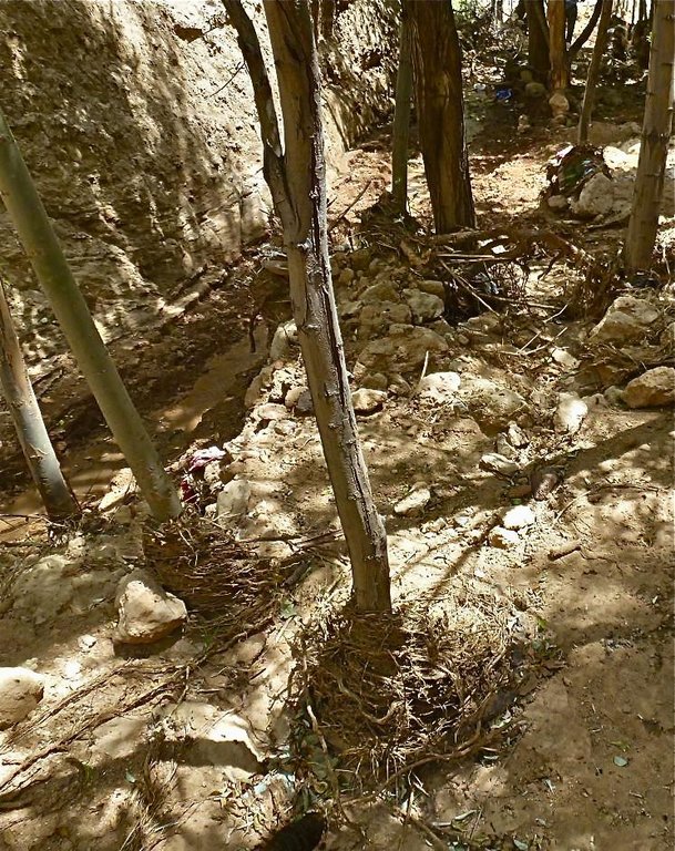
The extension of a deep incised gully, which borders a fertile orchard, is stopped and sediments are trapped by the help of vegetative and structural measures. The gully floor is vegetated with different trees inter alia willow, poplar, cherry, blackberry and walnut which are arranged in random groups. At the bottom of the gully where it intersects the road there is a stonewall, which collects the sediments that are washed down during heavy rainfalls mostly in spring. A dense bush line with Russian olives, apricots, cherries, walnuts, plums and buxus has been planted on the top of the side slopes of the gully, and roots of those bushes keep the soil stable and at the same time they prevent landslides and expansion of the gully. These tree lines are cut from time to time, otherwise they grow and become heavy and due to their weight the trees would possibly fall into the gully.
Purpose of the Technology: (1) The deep roots of willow trees on the bottom of the gully protect the soil and prevent it from being eroded during the heavy spring floods. Trees also help to collect sediment and to accumulate it in the gully. (2) The dense bush lines with its deep roots, on the top of the gully slope, stop the horizontal erosion, which endangers the fertile orchard close to the gully. (3) A stonewall at the lower end of the gully collects sediments which have been washed down. Once in a while a heightening of the stonewall has to be done. The technology with its three measures prevents from further gully expansion and supports its rehabilitation.
Establishment / maintenance activities and inputs: These three measures, the tree line, the bottom vegetation and the stonewall were developed and implemented by the farmer's own initiative. The farmer implemented the technology on his own and expands it every year. The entire technology doesn’t have to be established at once, which allows investing money and time whenever it is available. For maintenance new trees are planted both in the gully and in the tree line, which has to be cut and pruned from time to time. The technology is relatively affordable and facile to implement. At the beginning the farmer bought some seedlings. Meanwhile, the plants reproduce themselves and the farmer doesn't have to buy seedlings for further maintenance. The stones can be collected for free in the nearby riverbed. The work is done manually; no special tools are needed for the technology.
Natural / human environment: The farmer is proud of the outcome of his initiative. However he wishes that his neighbours would follow his lead, as for them it would be beneficial to implement the technology as well. He stated that usually people do not listen to a common farmer, but if the technology would be introduced by an official person it would spread out quickly.
2.3 صور التقنية
2.5 البلد/المنطقة/المواقع التي تم تنفيذ التقنية فيها والتي يغطيها هذا التقييم
البلد:
طاجيكستان
المنطقة/الولاية/المحافظة:
Tajikistan
مزيد من التفاصيل حول الموقع:
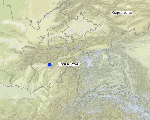
Faizabad, Javonon, Chinoro
التعليقات:
Boundary points of the Technology area: northernmost: 38°36'00.09"/69°23'58.93"
southernmost: 38°35'54.77"/69°24'03.18"
Map
×2.6 تاريخ التنفيذ
في حالة عدم معرفة السنة بالتحديد، يرجى الإشارة إلى التاريخ التقريبي:
- منذ 10-50 سنة
2.7 إدخال التقنية
حدد كيف تم إدخال التقنية:
- من خلال ابتكار مستخدمي الأراضي
التعليقات (نوع المشروع، الخ):
The farmer implemented the technology during the civil war and teached other farmers to do it. But it is not so easy for the farmer to convince other people to follow his example.
3. تصنيف تقنية الإدارة المستدامي للأراضي
3.1 الغرض الرئيسي ( الأغراض الرئيسية) للتقنية
- الحد من تدهور الأراضي ومنعه وعكسه
- حماية مستجمعات المياه / المناطق الواقعة في اتجاه مجرى النهر - مع تقنيات أخرى
3.2 نوع (أنواع) استخدام الأراضي الحالية حيث يتم تطبيق التقنية

المجاري المائية، المسطحات المائية، الأراضي الرطبة
- خطوط الصرف، الممرات المائية

أرض غير منتجة
حدد:
gully
التعليقات:
Major land use problems (compiler’s opinion): Highly erodible loess soil, and heavy rainfalls which causes a lot of surface runoff and erosion.
Major land use problems (land users’ perception): Lack of water for irrigation, too few rain, steep slopes, infertile soils which make the use of fertilizers essential.
Constraints of wastelands / deserts / glaciers / swamps
3.3 مزيد من المعلومات حول استخدام الأراضي
عدد مواسم الزراعة في السنة:
- 1
حدد:
Longest growing period in days: 210Longest growing period from month to month: March to August
3.4 مجموعةالإدارة المستدامة للأراضي التي تنتمي إليها هذه التقنية
- التدابير المتقاطعة للمنحدرات
- إدارة المياه السطحية (الينابيع، الأنهار، البحيرات، البحار)
3.5 انتشار التقنية
التعليقات:
Total area covered by the SLM Technology is 0.002138 m2.
3.6 التدابير التقنية في مجال إلادارة المستدامة للأراضي

التدابير النباتية
- V1: غطاء من الأشجار والشجيرات

التدابير البنيوية
- S6: الجدران والحواجز وسياجات القش، والسياجات
التعليقات:
Main measures: vegetative measures
Secondary measures: structural measures
Type of vegetative measures: aligned: -along boundary, scattered / dispersed
3.7 الأنواع الرئيسية من تدهور الأراضي التي تناولتها التقنية

تآكل التربة بالمياه
- (Wg):الانجراف الخلجاني/ الخلجان
- (Wm): مجموعة كبيرة من الحركات الأرضية/انزلاقات أرضية
- (Wr):انجراف ضفة النهر
التعليقات:
Main type of degradation addressed: Wg: gully erosion / gullying
Secondary types of degradation addressed: Wm: mass movements / landslides, Wr: riverbank erosion
Main causes of degradation: soil management (lack of knowledge for soil treatement, e.g. people dig hollows which support gully formation, agronoms from soviet times are missing), over-exploitation of vegetation for domestic use (Trees were cut for domestic use), overgrazing, disturbance of water cycle (infiltration / runoff), Heavy / extreme rainfall (intensity/amounts), land tenure (land is not private property), poverty / wealth (no money for tractors, fertilizers, education, etc.,), education, access to knowledge and support services, war and conflicts (during the civil war the land was not cultivated sustainably), governance / institutional (land use rights)
Secondary causes of degradation: deforestation / removal of natural vegetation (incl. forest fires), change in temperature (too hot and too cold temperatures dry out the soil, plants cannot survive), change of seasonal rainfall, population pressure, inputs and infrastructure: (roads, markets, distribution of water points, other, …) (lack of machinery to treat the field properly)
3.8 منع أو حد أو عكس تدهور الأراضي
تحديد هدف التقنية فيما يتعلق بتدهور الأراضي:
- منع تدهور الأراضي
- اصلاح/إعادة تأهيل الأراضي المتدهورة بشدة
التعليقات:
Main goals: prevention of land degradation, rehabilitation / reclamation of denuded land
4. المواصفات الفنية، وأنشطة التنفيذ، والمدخلات، والتكاليف
4.1 الرسم الفني للتقنية
4.2 المواصفات الفنية/شروحات الرسم الفني
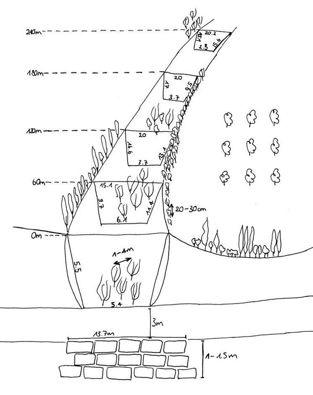
The technology includes three different sketch information; 1) dense tree lines on the top of the side slopes, 2) stonewall at the end of the gully and 3) willow trees at the bottom of the gully.
Location: Chinoro. Faizabad/Javonon/Tajikistan
Date: 03.09.2012
Technical knowledge required for field staff / advisors: high (People do not accept a suggestion if it is not from a good educated, accepted person.)
Technical knowledge required for land users: low
Main technical functions: control of concentrated runoff: impede / retard, increase of surface roughness, stabilisation of soil (eg by tree roots against land slides)
Secondary technical functions: control of concentrated runoff: retain / trap, improvement of ground cover, sediment retention / trapping, sediment harvesting, reduction in wind speed, increase of biomass (quantity), promotion of vegetation species and varieties (quality, eg palatable fodder)
Aligned: -contour
Vegetative material: T : trees / shrubs
Aligned: -along boundary
Vegetative material: T : trees / shrubs
Vertical interval within rows / strips / blocks (m): 0.2-0.4
Width within rows / strips / blocks (m): 2m (1-2 Row(s))
Scattered / dispersed
Vegetative material: T : trees / shrubs
Vertical interval within rows / strips / blocks (m): 1-4
Trees/ shrubs species: russian olive, willow tree, acacia, poplar, box
Fruit trees / shrubs species: walnut, apple, apricot, plum, cherries
Wall/ barrier
Vertical interval between structures (m): 0
Spacing between structures (m): 0
Depth of ditches/pits/dams (m): 1.5
Width of ditches/pits/dams (m): 3
Length of ditches/pits/dams (m): 13.7
Construction material (stone): Are taken from a nearby riverbed.
4.3 معلومات عامة بخصوص حساب المدخلات والتكاليف
عملة أخرى/ عملة وطنية (حدد):
Tajik Somoni
أشر إلى سعر الصرف من الدولار الأمريكي إلى العملة المحلية (إذا كان ذا صلة): 1 دولار أمريكي =:
4,7
اذكر متوسط تكلفة أجر العمالة المستأجرة في اليوم الواحد:
12.00
4.4 أنشطة التأسيس
| النشاط | نوع التدبير | التوقيت | |
|---|---|---|---|
| 1. | plant trees in the gully | نباتية | whole year |
| 2. | plant tree line | نباتية | whole year |
| 3. | build wall | بنيوية أو هيكلية |
4.5 التكاليف والمدخلات اللازمة للتأسيس
| تحديد المدخلات | الوحدة | الكمية | التكاليف لكل وحدة | إجمالي التكاليف لكل مدخل | % من التكاليف التي يتحملها مستخدمو الأراضي | |
|---|---|---|---|---|---|---|
| العمالة | Build wall | wall | 1,0 | 125,0 | 125,0 | 100,0 |
| العمالة | Planting trees | Persons/day | 3,0 | 12,0 | 36,0 | 100,0 |
| المواد النباتية | Tree seedlings | 1,0 | 166,0 | 166,0 | ||
| إجمالي تكاليف إنشاء التقنية | 327,0 | |||||
4.6 الصيانة/الأنشطة المتكررة
| النشاط | نوع التدبير | التوقيت/الوتيرة | |
|---|---|---|---|
| 1. | add trees in the gully | نباتية | spring |
| 2. | add trees in the tree line | نباتية | spring |
| 3. | increase the height of the stonewall | بنيوية أو هيكلية | once a while |
4.7 التكاليف والمدخلات اللازمة للصيانة/للأنشطة المتكررة (سنويًا)
| تحديد المدخلات | الوحدة | الكمية | التكاليف لكل وحدة | إجمالي التكاليف لكل مدخل | % من التكاليف التي يتحملها مستخدمو الأراضي | |
|---|---|---|---|---|---|---|
| العمالة | Add trees | Persons/day | 1,0 | 12,0 | 12,0 | 100,0 |
| العمالة | Increase the hight of the wall | - | ||||
| إجمالي تكاليف صيانة التقنية | 12,0 | |||||
التعليقات:
The fact that the inputs for the technology are not evenly distributed throughout the area, the costs were calculated for the whole technology area.
4.8 أهم العوامل المؤثرة على التكاليف
قدم وصفا لأهم العوامل التي تؤثر على التكاليف:
The material is relatively affordable. Money intensive factor are the seedlings during establishment phase. Following years the trees reproduce themselves. The establishment of the technology, the planting of the trees and the building of the stonewall require a lot of labour input in the initial phase. As the whole technology does not have to be implemented at once, the work can be split-up over years.
5. البيئة الطبيعية والبشرية
5.1 المناخ
هطول الأمطار السنوي
- < 250 مم
- 251- 500 ملم
- 501 - 750ملم
- 1,000-751 ملم
- 1,500-1,100 ملم
- 2,000-1,500 ملم
- 3,000-2,001 ملم
- 4,000-3,100 ملم
- > 4000 ملم
المنطقة المناخية الزراعية
- شبه قاحلة
Thermal climate class: temperate
5.2 طوبوغرافيا
متوسط الانحدارات:
- مسطح (0-2%)
- بسيط (3-5%)
- معتدل (6-10%)
- متدحرج (11-15%)
- تلال (16-30%)
- شديدة الانحدار(31-60%)
- فائقة الانحدار (>60%)
التضاريس:
- هضاب/سهول
- أثلام مرتفعة
- المنحدرات الجبلية
- منحدرات التلال
- منحدرات في السفوح
- قاع الوادي
المنطقة الارتفاعية:
- 100-0 متر فوق سطح البحر
- 500-101 متر فوق سطح البحر
- 1,000-501 متر فوق سطح البحر
- 1,500-1,001 متر فوق سطح البحر
- 2,000-1,501 متر فوق سطح البحر
- 2,500-2,100 متر فوق سطح البحر
- 3,000-2,501 متر فوق سطح البحر
- 4,000-3,001 متر فوق سطح البحر
- > 4000 متر فوق سطح البحر
5.3 التربة
متوسط عمق التربة:
- ضحل جدًا (0-20 سم)
- ضحلة (21-50 سم)
- متوسطة العمق (51-80 سم)
- عميقة (81-120 سم)
- عميقة جدًا (> 120 سم)
قوام التربة (التربة السطحية):
- خشن / خفيف (رملي)
المواد العضوية في التربة السطحية:
- متوسطة (1-3%)
- منخفضة (<1%)
إذا كان متاحًا، قم بإرفاق وصف كامل للتربة أو تحديد المعلومات المتوفرة، على سبيل المثال نوع التربة، الرقم الهيدروجيني/ درجة حموضة التربة، قدرة التبادل الكاتيوني، النيتروجين، الملوحة وما إلى ذلك.
Soil depth on average: No soil in the gully
Soil fertility is medium for the treeline on top of the slopes of the gully (close to the orchard). but in the gully its very low because the soil was washed away.
Topsoil organic matter is medium at the treeline on top of the gully slope.
Soil drainage / infiltration is medium and in the orchard, gully works as drainage
Soil water storage capacity is very low
5.4 توافر المياه ونوعيتها
منسوب المياه الجوفية:
> 50 م
توافر المياه السطحية:
ضعيف/ غير متوافر
نوعية المياه (غير المعالجة):
مياه شرب جيدة
5.5 التنوع البيولوجي
تنوع الأنواع:
- منخفض
5.6 خصائص مستخدمي الأراضي الذين يطبقون التقنية
الدخل من خارج المزرعة:
- أقل من % 10من كامل الدخل
المستوى النسبي للثروة:
- ضعيف
- متوسط
أفراداً أو مجموعات:
- فرد/أسرة معيشية
الجنس:
- رجال
اذكر الخصائص الأخرى ذات الصلة لمستخدمي الأراضي:
Land users applying the Technology are mainly common / average land users
Difference in the involvement of women and men: The technology was directed by the farmer and implemented by the farmer's son. Only men were involved in the technology. In Tajikistan usually work for men and women is strictly divided. Women work in the household, take care for children and work on the field. The gully rehabilitation project was men's work.
Population density: 100-200 persons/km2
Annual population growth: 2% - 3%
10% of the land users are rich (trader which buy and sell products from the farmers).
60% of the land users are average wealthy and own 80% of the land.
30% of the land users are poor and own 20% of the land.
Off-farm income specification: beneath the technology the farmer has an orchard with intercropping, a flax and a wheat plot.
5.7 متوسط مساحة الأرض المملوكة أو المستأجرة من قبل مستخدمي الأراضي الذين يطبقون التقنية
- < 0.5 هكتارا
- 0.5 - 1 هكتار
- 1 -2 هكتار
- 2 - 5 هكتار
- 5 - 15 هكتار
- 15 - 50 هكتار
- 50 - 100هكتار
- 500-100 هكتار
- 1,000-500 هكتار
- 10,000-1,000 هكتار
- > 10,000 هكتار
هل يعتبر هذا نطاقًا صغيرًا أو متوسطًا أو واسعا (في إشارة إلى السياق المحلي)؟:
- على نطاق صغير
5.8 ملكية الأراضي، وحقوق استخدام الأراضي، وحقوق استخدام المياه
ملكية الارض:
- دولة
حقوق استخدام الأراضي:
- وصول مفتوح (غير منظم)
حقوق استخدام المياه:
- مجتمعي (منظم)
5.9 الوصول إلى الخدمات والبنية التحتية
الصحة:
- ضعيف
- معتدل
- جيد
التعليم:
- ضعيف
- معتدل
- جيد
المساعدة التقنية:
- ضعيف
- معتدل
- جيد
العمل (على سبيل المثال خارج المزرعة):
- ضعيف
- معتدل
- جيد
الأسواق:
- ضعيف
- معتدل
- جيد
الطاقة:
- ضعيف
- معتدل
- جيد
الطرق والنقل:
- ضعيف
- معتدل
- جيد
مياه الشرب وخدمات الصرف الصحي:
- ضعيف
- معتدل
- جيد
الخدمات المالية:
- ضعيف
- معتدل
- جيد
6. الآثار والتصريحات الختامية
6.1 الآثار التي أظهرتها التقنية في الموقع
الآثار الاجتماعية والاقتصادية
الإنتاج
إنتاج الخشب
منطقة الإنتاج
الدخل والتكاليف
النفقات على المدخلات الزراعية
التعليقات/ حدد:
Especially at the time of establishment.
الآثار الاجتماعية والثقافية
المعرفة بالإدارة المستدامة للأراضي/تدهور الأراضي
التعليقات/ حدد:
Land users acquired new knowledge.
security to have fertile land
الآثار الايكولوجية
دورة المياه / الجريان السطحي
الجريان السطحي
التربة
غطاء التربة
فقدان التربة
التنوع البيولوجي: الغطاء النباتي، الحيوانات
الكتلة الحيوية/ طبقة الكربون فوق التربة
التنوع النباتي
التنوع الحيواني
الأنواع المفيدة
تنوع الموائل
الحد من مخاطر المناخ والكوارث
سرعة الرياح
التعليقات/ حدد:
Treeline
6.2 الآثار التي أظهرتها التقنية خارج الموقع
الفيضان في اتجاه مجرى النهر
تراكم الطمي باتجاه مصب النهر
6.3 تعرض التقنية وحساسيتها لتغير المناخ التدريجي والظواهر المتطرفة/الكوارث المرتبطة بالمناخ (كما يراها مستخدمو الأراضي)
تغير مناخ تدريجي
تغير مناخ تدريجي
| الموسم | نوع التغير المناخي/ المتطرف | كيف تتعامل التقنية مع ذلك؟ | |
|---|---|---|---|
| درجة الحرارة السنوية | زيادة | غير معروف |
الظواهر المتطرفة / الكوارث المرتبطة بالمناخ
الكوارث الجوية
| كيف تتعامل التقنية مع ذلك؟ | |
|---|---|
| عاصفة ممطرة محلية | ليس جيدا |
| عاصفة هوائية محلية | جيدا |
الكوارث المناخية
| كيف تتعامل التقنية مع ذلك؟ | |
|---|---|
| جفاف | ليس جيدا |
العواقب الأخرى المتعلقة بالمناخ
العواقب الأخرى المتعلقة بالمناخ
| كيف تتعامل التقنية مع ذلك؟ | |
|---|---|
| انخفاض فترة النمو | ليس جيدا |
التعليقات:
On the bottom of the gully willow trees should be planted which have strong roots to resist floods, especially if the gully is already deep. At the slopes Russian olives and wild cherries can be planted. The higher amount of trees makes gully even more stable.
6.4 تحليل التكلفة والعائد
كيف يمكن مقارنة العوائد نسبة لتكاليف الإنشاء (من وجهة نظر مستخدمي الأراضي)؟
عوائد قصيرة الأجل:
محايد/متوازن
عوائد طويلة الأجل:
ايجابي جدا
كيف تتم مقارنة العوائدمع كلفة الصيانة/التكاليف المتكررة (من وجهة نظر مستخدمي الأراضي)؟
عوائد قصيرة الأجل:
إيجابي
عوائد طويلة الأجل:
ايجابي جدا
التعليقات:
Much more extra work comes up for the establishment, but for the farmer work is not a disadvantage.
6.5 اعتماد التقنية
التعليقات:
There is a little trend towards spontaneous adoption of the Technology
6.7 نقاط القوة / المزايا / الفرص التي توفرها التقنية
| نقاط القوة/ المزايا/ الفرص من وجهة نظر مستخدمي الأراضي |
|---|
|
Stopping the expansion (prevention) of the gully and filling up the gully (rehabilitation). How can they be sustained / enhanced? Maintain the vegetative measures, plant more seedlings and let them reproduce themselves. |
|
Firewood and construction material production. How can they be sustained / enhanced? Increase the vegetation with wood of good quality and use it in a sustainable manner (cut only as much as will be reproduced). |
| نقاط القوة/ المزايا/ الفرص من وجهة نظر جامع المعلومات أو غيره من الاشخاص الرئيسيين لمصدر المعلومات |
|---|
|
Extensive use of the area and a relatively rich diversity of local vegetation. The maintained gully provides new habitat for natural flora and fauna. How can they be sustained / enhanced? Keep and promote the diversity of plants in the gully. |
|
Cheap and relatively less labor intensive work. Relatively little knowledge and no special tools are required. How can they be sustained / enhanced? Make the technology public. |
| The entire technology doesn’t have to be established at once, which allows investing money and time whenever it is available. |
6.8 نقاط ضعف / مساوىء / مخاطر التقنية وسبل التغلب عليها
| نقاط الضعف/ المساوىء/ المخاطر من وجهة نظر مستخدم الأراضي | كيف يمكن التغلب عليها؟ |
|---|---|
| The trees stop the water, sediments, branches etc. too effectively and this creates problems with too much water in the gully, which is washing out the sides of the gully. |
| نقاط الضعف/ المساوىء/ المخاطر من وجهة نظر جامع المعلومات أو غيره من الاشخاص الرئيسيين لمصدر المعلومات | كيف يمكن التغلب عليها؟ |
|---|---|
| A disadvantage is the extra work the farmer have to spend on a little productive area. | In the land users view work is not a disadvantage, it is his job. Considering the fact that it is not that much extra work, it is not a big disadvantage. |
| For the establishment a first investment for the seedlings is required. | An establishment of the technology during a longer period allows to grow own seedlings from the plants which do not cost anything. |
7. المراجع والروابط
7.2 المراجع للمنشورات المتاحة
العنوان، المؤلف، السنة، النظام القياسي الدولي لترقيم الكتب ISBN:
Integrated spatial assessment for Sustainable Land Management „SLM-planning“ in the loess hill of central Tajikistan using WOCAT mapping tools (working title), Selina Studer, 2013, Master Thesis, University of Bern, Bern.
متاح من أين؟كم التكلفة؟:
University of Bern
7.3 روابط للمعلومات ذات الصلة المتوفرة على الإنترنت
العنوان/الوصف:
WOCAT technology movie: Orchard-Based Agroforestry
عنوان الرابط URL:
wocat@cde.ch
الروابط والوحدات المواضيعية
توسيع الكل طي الكلالروابط
لا يوجد روابط
الوحدات المواضيعية
لا يوجد وحدات مواضيعية


