Stonelines [كينيا]
- تاريخ الإنشاء:
- تحديث:
- جامع المعلومات: Paul Kahiga
- المحرر: –
- المُراجع: David Streiff
Miraini ya maviga
technologies_1581 - كينيا
عرض الأقسام
توسيع الكل طي الكل1. معلومات عامة
1.2 تفاصيل الاتصال بالأشخاص الرئيسيين لمصدر المعلومات والمؤسسات المشاركة في تقييم وتوثيق التقنية
متخصص في الإدارة المستدامة للأراضي:
Mwangi Gathenya
JKUAT
كينيا
متخصص في الإدارة المستدامة للأراضي:
Home Patrick
JKUAT
كينيا
متخصص في الإدارة المستدامة للأراضي:
Wamuongo Jane
KARI
كينيا
متخصص في الإدارة المستدامة للأراضي:
Namirembe Sara
ICRAF
كينيا
متخصص في الإدارة المستدامة للأراضي:
Chege Timothy
JKUAT
كينيا
متخصص في الإدارة المستدامة للأراضي:
Karanja Andrew
KARI
كينيا
اسم المؤسسة (المؤسسات) التي سهلت توثيق/تقييم التقنية (إذا كان ذلك على صلة)
International Centre for Research in Agroforestry (ICRAF) - كينيااسم المؤسسة (المؤسسات) التي سهلت توثيق/تقييم التقنية (إذا كان ذلك على صلة)
KARI Headquarters (KARI Headquarters) - كينيااسم المؤسسة (المؤسسات) التي سهلت توثيق/تقييم التقنية (إذا كان ذلك على صلة)
Jomo Kenyatta University (Jomo Kenyatta University) - كينيا1.3 الشروط المتعلقة باستخدام البيانات الموثقة من خلال WOCAT
متى تم تجميع البيانات (ميدانيا)؟:
08/02/2011
يوافق جامع المعلومات والشخص (لاشخاص) الرئيسي لمصدر المعلومات على الشروط المتعلقة باستخدام البيانات الموثقة من خلال WOCAT:
نعم
2. وصف تقنيةالإدارة المستدامي للأراضي
2.1 وصف مختصر للتقنية
تعريف التقنية:
Stonelines are constructed along the contours to slow down the speed of runoff, filter the soil and enhance water infiltration.
2.2 وصف تفصيلي للتقنية
الوصف:
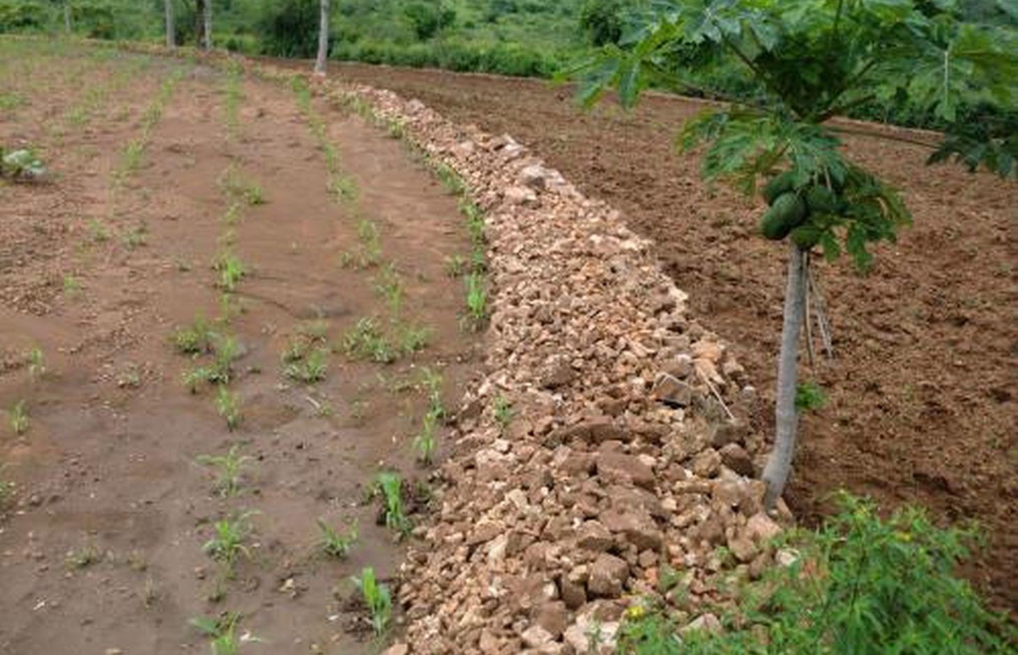
In Kenya stone lines are mostly practiced in areas that receive 200-750 mm of annual rainfall with a spacing of 15-30 m between them. They are particularly common in areas where rocks are readily available, such as Mbeere, Laikipia, Baringo, Mwingi, Kitui and Tharaka. Since the stonelines are permeable they do not pond runoff water but instead, they slow down the speed, filter it and spread the water over the field, thus enhancing water infiltration and reducing soil erosion. They are built in series running along the slope. In addition, the stone barrier blocks and settles down the sediments transported from the upper slopes.
Purpose of the Technology: They are often used to rehabilitate eroded and abandoned land. The advantages of stonelines include; slowing down the runoff thereby increasing infiltration and soil moisture. They also induce a natural process of terracing, reducing erosion and rehabilitation of eroded lands by trapping silt. They are easy to design and construct and since the stone line structure is permeable there is no need for construction of spillways to drain the excess runoff water. When it rains, the soil builds up on the upslope side of the stonelines and over time a natural terrace is formed.
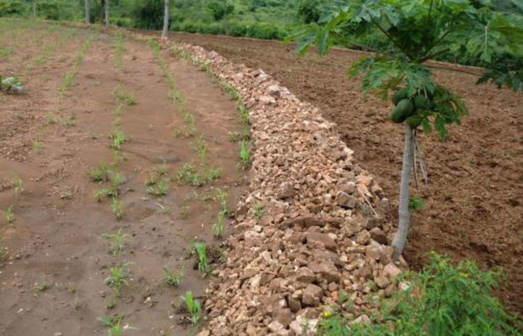
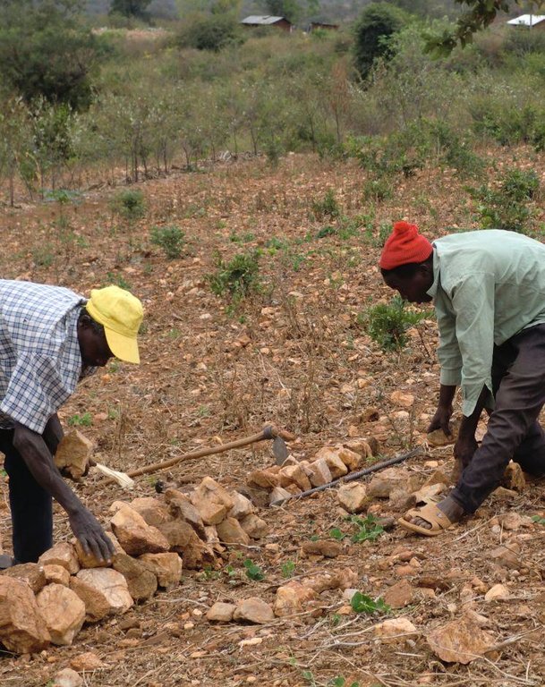
Establishment / maintenance activities and inputs: The stonelines are spaced 15-30 m apart, a shorter distance being used for the steeper slopes. Stonelines are normally suitable on gentle slopes. Slopes above 35% should be avoided. They are established in the following manner: first, the contour line are marked out with the help of a tube level or line levels. In this region here, it is done with the help of the frontline agricultural extension officers. Secondly, a shallow foundation trench is dug across the slope (5-10 cm to 30 cm deep) using basic farm equipments (jembes or hoes). As shown on the above photographs, the larger stones are put on the down slope side of the trench while the smaller stones are used to build the rest of the bund. The smallest stones are used to fill the gaps and increase the heights of the bunds up to the desired level. Farmers plant fruit trees (pawpaws) as show in the photograph above on the upper part. The trees utilises the moisture and rich sediments deposited on the upper part. The stonelines can be reinforced with earth, or crop residues to make them more stable. Maintenance of stonelines is done by repairing the already damaged /fallen stoneline that may have been knocked down or disarranged by livestock or by human beings. In this case animal access needs to be limited and/or the bund should be laid out in a way that allows the animals to pass through.
Natural / human environment: In the lower Mbeere South District where the stoneline technologies is largely practiced, unless there are stones in the individual farms, it might be difficult to import stones from other farms as the exercise can be labor intensive. In this catchment, the Ministry of Agriculture through the front line extension officers has taken a lead role in encouraging farmers to adopt the technology especially the farms which have many stones. Most of the farmers who have implemented this technology in the Lower Mbeere South District learn from the ones who are already practicing through field days or individual initiatives.
2.3 صور التقنية
2.5 البلد/المنطقة/المواقع التي تم تنفيذ التقنية فيها والتي يغطيها هذا التقييم
البلد:
كينيا
المنطقة/الولاية/المحافظة:
Eastern Province
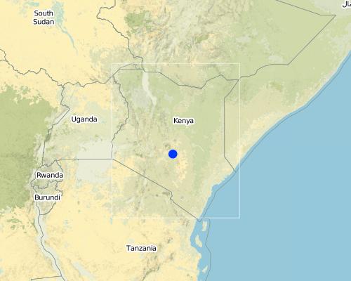
مزيد من التفاصيل حول الموقع:
Mbeere South District
Map
×2.6 تاريخ التنفيذ
في حالة عدم معرفة السنة بالتحديد، يرجى الإشارة إلى التاريخ التقريبي:
- منذ 10-50 سنة
2.7 إدخال التقنية
حدد كيف تم إدخال التقنية:
- من خلال ابتكار مستخدمي الأراضي
التعليقات (نوع المشروع، الخ):
The land had too many stones which inhibited operations. By removing the stones, the farmer placed them in line along the contour.
3. تصنيف تقنية الإدارة المستدامي للأراضي
3.1 الغرض الرئيسي ( الأغراض الرئيسية) للتقنية
- الحد من تدهور الأراضي ومنعه وعكسه
3.2 نوع (أنواع) استخدام الأراضي الحالية حيث يتم تطبيق التقنية

الأراضي الزراعية
- زراعة سنوية
- زراعة معمرة (غير خشبية)
- زراعة الأشجار والشجيرات
المحاصيل الرئيسية (المحاصيل النقدية والغذائية):
major cash crop (CA): Sorghum, maize
major cash crop (CP): Mangoes, pawpaws
major cash crop (CT): Miraa
major food crop (CA): Millet, cowpeas
التعليقات:
Major land use problems (compiler’s opinion): Limited cultivation land due to hindrances that are brought about by the scattered stones on the land's surface.
Major land use problems (land users’ perception): Soil erosion because of lack of soil and water conservation structures that leads to low land productivity.
Future (final) land use (after implementation of SLM Technology): Cropland: Ca: Annual cropping
إذا تغير استخدام الأراضي بسبب التقنية، قم بالإشارة إلى استخدام الأرض قبل تنفيذ التقنية:
Cropland: Ct: Tree and shrub cropping
3.3 مزيد من المعلومات حول استخدام الأراضي
إمدادات المياه للأرض التي يتم تنفيذ التقنية عليها:
- بعلية
عدد مواسم الزراعة في السنة:
- 2
حدد:
Longest growing period in days: 90 Longest growing period from month to month: March-May Second longest growing period in days: 90 Second longest growing period from month to month: October - December
3.4 مجموعةالإدارة المستدامة للأراضي التي تنتمي إليها هذه التقنية
- تحويل المياه والصرف
3.5 انتشار التقنية
حدد انتشار التقنية:
- منتشرة بالتساوي على مساحة
إذا كانت التقنية منتشرة بالتساوي على منطقة ما، فحدد المنطقة التقريبية المغطاة:
- < 0.1 كم2 (10 هكتار)
التعليقات:
Not many farmers are practicing stonelines, the farmers who are practicing are copying from some successful farmers within their neighborhood. They also corroborate with the local agricultural extension officers from the Ministry of Agriculture (MoA) to show them how to construct the stonelines along the contours.
3.6 التدابير التقنية في مجال إلادارة المستدامة للأراضي

التدابير البنيوية
- الحواجز والضفاف
3.7 الأنواع الرئيسية من تدهور الأراضي التي تناولتها التقنية

تآكل التربة بالمياه
- الوزن(Wt): فقدان التربة السطحية/تآكل السطح
التعليقات:
Main type of degradation addressed: Wt: loss of topsoil / surface erosion
Main causes of degradation: soil management, Heavy / extreme rainfall (intensity/amounts), poverty / wealth, labour availability (Construction of the technology is labour intensive)
Secondary causes of degradation: deforestation / removal of natural vegetation (incl. forest fires)
3.8 منع أو حد أو عكس تدهور الأراضي
تحديد هدف التقنية فيما يتعلق بتدهور الأراضي:
- منع تدهور الأراضي
- اصلاح/إعادة تأهيل الأراضي المتدهورة بشدة
التعليقات:
Secondary goals: mitigation / reduction of land degradation
4. المواصفات الفنية، وأنشطة التنفيذ، والمدخلات، والتكاليف
4.1 الرسم الفني للتقنية
4.2 المواصفات الفنية/شروحات الرسم الفني
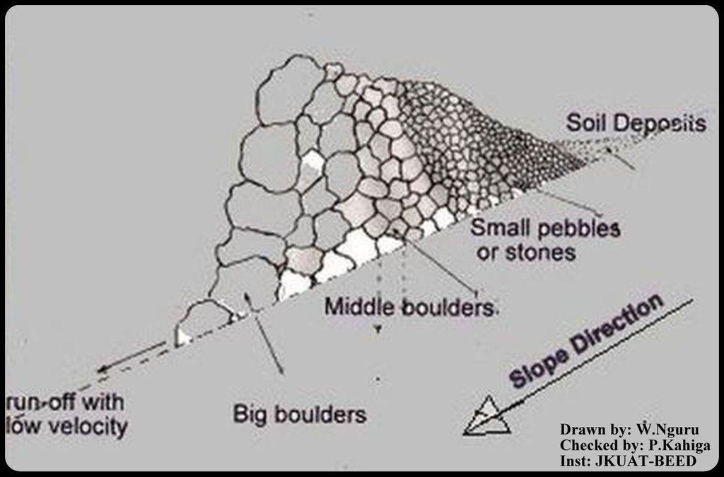
This is a technical drawing representing a cross-section view of how the stonelines are constructed by the emerging farmers in the lower Mbeere South District.
First, a small trench is dug along an established contour line, the farmer starts arranging the stones with reference to their sizes. The bigger ones are arranged on the lower side and the small ones on the upper side as shown on the technical drawing.
By so doing, the eroded soils are trapped on the upper side by the small pebbles, allowing the water to pass through at lower speed hence low erosive capacity.
Location: Ntharawe. Lower Mbeere South District
Date: 2011-08-02
Technical knowledge required for field staff / advisors: moderate (In order to implement this technology, the farmers contact the front line agricultural extension officer in order to assist in making the contours.)
Technical knowledge required for land users: high (Stone required placement of a certain order. Big stone on the lower side and small stones on the upper side-Vertically)
Main technical functions: water spreading, sediment retention / trapping, sediment harvesting
Secondary technical functions: reduction of slope angle
Bund/ bank: graded
Spacing between structures (m): 15
Height of bunds/banks/others (m): 0.8
Width of bunds/banks/others (m): 1.2
Length of bunds/banks/others (m): 27.6
Slope (which determines the spacing indicated above): 8%
Lateral gradient along the structure: 8%
4.3 معلومات عامة بخصوص حساب المدخلات والتكاليف
حدد كيفية احتساب التكاليف والمدخلات:
- لكل وحدة تقنية
حدد الوحدة:
Stonelines
عملة أخرى/ عملة وطنية (حدد):
Kshs
أشر إلى سعر الصرف من الدولار الأمريكي إلى العملة المحلية (إذا كان ذا صلة): 1 دولار أمريكي =:
80,0
اذكر متوسط تكلفة أجر العمالة المستأجرة في اليوم الواحد:
2.50
4.4 أنشطة التأسيس
| النشاط | نوع التدبير | التوقيت | |
|---|---|---|---|
| 1. | Establish a contour line and dig up a trench upon which the stones will be arranged | بنيوية أو هيكلية | yearly |
| 2. | stones are collected and arranged along the established trench. The big boulders are reduced to the required sizes by the use of mattocks | بنيوية أو هيكلية | once |
| 3. | The big stones are arranged on the lower side and the rest follows with respect to their sizes on the upper side | بنيوية أو هيكلية | |
| 4. | This formation is done per meter length. Mostly is charged 150Kshs per meter. | بنيوية أو هيكلية |
4.5 التكاليف والمدخلات اللازمة للتأسيس
| تحديد المدخلات | الوحدة | الكمية | التكاليف لكل وحدة | إجمالي التكاليف لكل مدخل | % من التكاليف التي يتحملها مستخدمو الأراضي | |
|---|---|---|---|---|---|---|
| العمالة | Establish a contour line | Persons/day | 0,5 | 3,76 | 1,88 | 100,0 |
| العمالة | Reduce stone size | Persons/day | 0,5 | 3,76 | 1,88 | 100,0 |
| العمالة | Arranging stones | Persons/day | 0,5 | 3,76 | 1,88 | 100,0 |
| معدات | Mattock | pieces | 1,0 | 18,75 | 18,75 | 100,0 |
| معدات | Wheelbarrow | pieces | 1,0 | 20,0 | 20,0 | 100,0 |
| مواد البناء | Stone | no | 1,0 | 1,88 | 1,88 | 100,0 |
| إجمالي تكاليف إنشاء التقنية | 46,27 | |||||
التعليقات:
Duration of establishment phase: 1 month(s)
4.6 الصيانة/الأنشطة المتكررة
| النشاط | نوع التدبير | التوقيت/الوتيرة | |
|---|---|---|---|
| 1. | Repair/Rearrange stone on stone line after a rainy seasons or when people and animals have destroyed the stone line. | بنيوية أو هيكلية | yearly during dry season |
4.7 التكاليف والمدخلات اللازمة للصيانة/للأنشطة المتكررة (سنويًا)
| تحديد المدخلات | الوحدة | الكمية | التكاليف لكل وحدة | إجمالي التكاليف لكل مدخل | % من التكاليف التي يتحملها مستخدمو الأراضي | |
|---|---|---|---|---|---|---|
| العمالة | Repair/Rearrange stone | mandays/acre | 14,0 | 2,5 | 35,0 | 100,0 |
| إجمالي تكاليف صيانة التقنية | 35,0 | |||||
التعليقات:
Machinery/ tools: A wheel barrow (for carrying) and mattocks (for breaking) may be used
The cost applies for the year 2011 and was calculated per metre square, metre length, metre height and metre width.
4.8 أهم العوامل المؤثرة على التكاليف
قدم وصفا لأهم العوامل التي تؤثر على التكاليف:
The system is labour intensive and hence will affect the cost of constructing the stonelines. However, availability of farm equipments like wheelbarrows, mattocks or oxen will help reduce the total cost and time required for construction and maintaining the stonelines. On steep slopes, the spacing between the lines is small as compared to a relatively gentle slope.
5. البيئة الطبيعية والبشرية
5.1 المناخ
هطول الأمطار السنوي
- < 250 مم
- 251- 500 ملم
- 501 - 750ملم
- 1,000-751 ملم
- 1,500-1,100 ملم
- 2,000-1,500 ملم
- 3,000-2,001 ملم
- 4,000-3,100 ملم
- > 4000 ملم
المواصفات/التعليقات على هطول الأمطار:
Annual rainfall: Also < 250 mm
المنطقة المناخية الزراعية
- شبه قاحلة
Thermal climate class: tropics
5.2 طوبوغرافيا
متوسط الانحدارات:
- مسطح (0-2%)
- بسيط (3-5%)
- معتدل (6-10%)
- متدحرج (11-15%)
- تلال (16-30%)
- شديدة الانحدار(31-60%)
- فائقة الانحدار (>60%)
التضاريس:
- هضاب/سهول
- أثلام مرتفعة
- المنحدرات الجبلية
- منحدرات التلال
- منحدرات في السفوح
- قاع الوادي
المنطقة الارتفاعية:
- 100-0 متر فوق سطح البحر
- 500-101 متر فوق سطح البحر
- 1,000-501 متر فوق سطح البحر
- 1,500-1,001 متر فوق سطح البحر
- 2,000-1,501 متر فوق سطح البحر
- 2,500-2,100 متر فوق سطح البحر
- 3,000-2,501 متر فوق سطح البحر
- 4,000-3,001 متر فوق سطح البحر
- > 4000 متر فوق سطح البحر
5.3 التربة
متوسط عمق التربة:
- ضحل جدًا (0-20 سم)
- ضحلة (21-50 سم)
- متوسطة العمق (51-80 سم)
- عميقة (81-120 سم)
- عميقة جدًا (> 120 سم)
قوام التربة (التربة السطحية):
- خشن / خفيف (رملي)
المواد العضوية في التربة السطحية:
- منخفضة (<1%)
إذا كان متاحًا، قم بإرفاق وصف كامل للتربة أو تحديد المعلومات المتوفرة، على سبيل المثال نوع التربة، الرقم الهيدروجيني/ درجة حموضة التربة، قدرة التبادل الكاتيوني، النيتروجين، الملوحة وما إلى ذلك.
Soil texture: With a lot of stones
Soil fertility is medium
Soil drainage / infiltration is medium
Soil water storage capacity is medium
5.4 توافر المياه ونوعيتها
منسوب المياه الجوفية:
> 50 م
توافر المياه السطحية:
ضعيف/ غير متوافر
نوعية المياه (غير المعالجة):
مياه شرب جيدة
تعليقات ومواصفات أخرى بشأن نوعية المياه وكميتها:
Availability of surface water: The rivers are seasonal, water availability is from river beds if not during the rainy seasons
5.5 التنوع البيولوجي
تنوع الأنواع:
- متوسط
5.6 خصائص مستخدمي الأراضي الذين يطبقون التقنية
التوجه السوقي لنظام الإنتاج:
- مختلط (كفاف/ تجاري)
الدخل من خارج المزرعة:
- أقل من % 10من كامل الدخل
المستوى النسبي للثروة:
- ضعيف
أفراداً أو مجموعات:
- فرد/أسرة معيشية
مستوى المكننة:
- عمل يدوي
- الجر الحيواني
الجنس:
- رجال
اذكر الخصائص الأخرى ذات الصلة لمستخدمي الأراضي:
Land users applying the Technology are mainly common / average land users
Population density: 10-50 persons/km2
Annual population growth: < 0.5%
80% of the land users are poor.
5.7 متوسط مساحة الأرض المملوكة أو المستأجرة من قبل مستخدمي الأراضي الذين يطبقون التقنية
- < 0.5 هكتارا
- 0.5 - 1 هكتار
- 1 -2 هكتار
- 2 - 5 هكتار
- 5 - 15 هكتار
- 15 - 50 هكتار
- 50 - 100هكتار
- 500-100 هكتار
- 1,000-500 هكتار
- 10,000-1,000 هكتار
- > 10,000 هكتار
هل يعتبر هذا نطاقًا صغيرًا أو متوسطًا أو واسعا (في إشارة إلى السياق المحلي)؟:
- على نطاق صغير
5.8 ملكية الأراضي، وحقوق استخدام الأراضي، وحقوق استخدام المياه
ملكية الارض:
- فردية، يوجد سند ملكية
5.9 الوصول إلى الخدمات والبنية التحتية
الصحة:
- ضعيف
- معتدل
- جيد
التعليم:
- ضعيف
- معتدل
- جيد
المساعدة التقنية:
- ضعيف
- معتدل
- جيد
العمل (على سبيل المثال خارج المزرعة):
- ضعيف
- معتدل
- جيد
الأسواق:
- ضعيف
- معتدل
- جيد
الطاقة:
- ضعيف
- معتدل
- جيد
الطرق والنقل:
- ضعيف
- معتدل
- جيد
مياه الشرب وخدمات الصرف الصحي:
- ضعيف
- معتدل
- جيد
الخدمات المالية:
- ضعيف
- معتدل
- جيد
6. الآثار والتصريحات الختامية
6.1 الآثار التي أظهرتها التقنية في الموقع
الآثار الاجتماعية والاقتصادية
الإنتاج
إنتاج المحاصيل
خطر فشل الإنتاج
منطقة الإنتاج
إدارة الأراضي
التعليقات/ حدد:
Such that it hinders mechanisation tractors cannot operate due to the stone line arragement
الدخل والتكاليف
عبء العمل
التعليقات/ حدد:
The operation is labour intensive
آثار اجتماعية واقتصادية أخرى
Livelihood and human well-being
التعليقات/ حدد:
Increased food security (the yield near the stoneline is better as compared to the situation that it was before implementation).
الآثار الاجتماعية والثقافية
المعرفة بالإدارة المستدامة للأراضي/تدهور الأراضي
وضع الفئات المحرومة اجتماعيا واقتصاديا
الآثار الايكولوجية
التربة
رطوبة التربة
فقدان التربة
التنوع البيولوجي: الغطاء النباتي، الحيوانات
مكافحة الآفات/الأمراض
التعليقات/ حدد:
Snakes and scorpions
الحد من مخاطر المناخ والكوارث
آثار الفيضانات
6.2 الآثار التي أظهرتها التقنية خارج الموقع
الفيضان في اتجاه مجرى النهر
القدرة على التخفيف / الترشيح
6.3 تعرض التقنية وحساسيتها لتغير المناخ التدريجي والظواهر المتطرفة/الكوارث المرتبطة بالمناخ (كما يراها مستخدمو الأراضي)
تغير مناخ تدريجي
تغير مناخ تدريجي
| الموسم | نوع التغير المناخي/ المتطرف | كيف تتعامل التقنية مع ذلك؟ | |
|---|---|---|---|
| درجة الحرارة السنوية | زيادة | جيدا |
الظواهر المتطرفة / الكوارث المرتبطة بالمناخ
الكوارث الجوية
| كيف تتعامل التقنية مع ذلك؟ | |
|---|---|
| عاصفة ممطرة محلية | ليس جيدا |
| عاصفة هوائية محلية | جيدا |
الكوارث المناخية
| كيف تتعامل التقنية مع ذلك؟ | |
|---|---|
| جفاف | جيدا |
الكوارث الهيدرولوجية
| كيف تتعامل التقنية مع ذلك؟ | |
|---|---|
| فيضان عام (نهر) | ليس جيدا |
6.4 تحليل التكلفة والعائد
كيف يمكن مقارنة العوائد نسبة لتكاليف الإنشاء (من وجهة نظر مستخدمي الأراضي)؟
عوائد قصيرة الأجل:
إيجابي قليلا
عوائد طويلة الأجل:
إيجابي
كيف تتم مقارنة العوائدمع كلفة الصيانة/التكاليف المتكررة (من وجهة نظر مستخدمي الأراضي)؟
عوائد قصيرة الأجل:
إيجابي
عوائد طويلة الأجل:
إيجابي
6.5 اعتماد التقنية
التعليقات:
There is a moderate trend towards spontaneous adoption of the Technology
Comments on adoption trend: The technology is mainly practiced on the farms with stones even though the farmers admit that the task of construction is labour intensive. However, these not withstanding, the farmers do acknowledge that the technology is beneficial since they can see the results of yields from the ones who are already practicing.
6.7 نقاط القوة / المزايا / الفرص التي توفرها التقنية
| نقاط القوة/ المزايا/ الفرص من وجهة نظر مستخدمي الأراضي |
|---|
|
By concentrating the stones along a contour, the farmer is able to make use of the land which otherwise is not possible if the stones are scatered. How can they be sustained / enhanced? Farmers should be encouraged to learn from one another but they should also seek advice from extension officers in making the contours. |
| The cost of replacement of farm equipments (jembes, forks and pangas) is reduced since they aren't broken by stones during land preparation. |
| نقاط القوة/ المزايا/ الفرص من وجهة نظر جامع المعلومات أو غيره من الاشخاص الرئيسيين لمصدر المعلومات |
|---|
|
The stones for constructing the technology are readily available in most of the farms. How can they be sustained / enhanced? Encouraging farmers to use the available stones to put up the technology. |
|
Stoneline technology prevents soil loss due to erosion. How can they be sustained / enhanced? Modification of the technology to allow more infiltration. |
|
No high level technical knowledge is required for construction of stoneline technology. How can they be sustained / enhanced? More farmers should be encouraged to adopt the technology since they dont need a high level of technical knowledge. |
|
Stone lines technology can be modified to prevent soil and water from running off on the side of stone line ridge. How can they be sustained / enhanced? Construction of side ridges. |
6.8 نقاط ضعف / مساوىء / مخاطر التقنية وسبل التغلب عليها
| نقاط الضعف/ المساوىء/ المخاطر من وجهة نظر مستخدم الأراضي | كيف يمكن التغلب عليها؟ |
|---|---|
| Contour profiling is challenging. | Assistance from the front line agricultural extension officers. |
| نقاط الضعف/ المساوىء/ المخاطر من وجهة نظر جامع المعلومات أو غيره من الاشخاص الرئيسيين لمصدر المعلومات | كيف يمكن التغلب عليها؟ |
|---|---|
| Labour intensive. | When constructing, always move the stones downslope by gravity instead of moving upwards i.e. start from the contours from the upper side |
| The technology only allows the soil to deposit on the upper side of the stoneline but water passes through. | Proper arrangement of the stones should be enhanced basing on their sizes. |
| Increased habitats for snakes and other dangerous creatures like scorpions that hide on the stonelines. | Where there creatures are prone, the farmers should be careful. |
7. المراجع والروابط
7.2 المراجع للمنشورات المتاحة
العنوان، المؤلف، السنة، النظام القياسي الدولي لترقيم الكتب ISBN:
Thomas, D.B. (eds) 1997. Soil and Water Conservation Manual for Kenya. Soil and Water Conservation Branch. Ministry of Agriculture, Livestock Development and Marketing. 210 p.
العنوان، المؤلف، السنة، النظام القياسي الدولي لترقيم الكتب ISBN:
Critchley W and Seigert K (1991) Water Harvesting. FAO
الروابط والوحدات المواضيعية
توسيع الكل طي الكلالروابط
لا يوجد روابط
الوحدات المواضيعية
لا يوجد وحدات مواضيعية


