Grass Covered Riparian Buffer Strips [Norway]
- Creation:
- Update:
- Compiler: Zhanguo Bai
- Editor: –
- Reviewer: Fabian Ottiger
Grasdekt buffersone
technologies_1656 - Norway
- Full summary as PDF
- Full summary as PDF for print
- Full summary in the browser
- Full summary (unformatted)
- Grass buffer zones alongside waterways in cropland: 3 فبراير، 2023 (public)
- Grass buffer zones alongside waterways in cropland: 17 يونيو، 2022 (inactive)
- Grass Covered Riparian Buffer Strips: 5 سبتمبر، 2019 (inactive)
- Grass Covered Riparian Buffer Strips: 16 مارس، 2017 (inactive)
- Grass Covered Riparian Buffer Strips: 16 مارس، 2017 (inactive)
View sections
Expand all Collapse all1. معلومات عامة
1.2 Contact details of resource persons and institutions involved in the assessment and documentation of the Technology
Name of the institution(s) which facilitated the documentation/ evaluation of the Technology (if relevant)
Norwegian Institute for Agricultural and Environme (Norwegian Institute for Agricultural and Environme) - Norway1.3 Conditions regarding the use of data documented through WOCAT
When were the data compiled (in the field)?
13/08/2014
The compiler and key resource person(s) accept the conditions regarding the use of data documented through WOCAT:
نعم
2. Description of the SLM Technology
2.1 Short description of the Technology
Definition of the Technology:
Establishment of grass covered vegetation strips along cropland waterways for reduced erosion and infiltration of surface runoff.
2.2 Detailed description of the Technology
Description:
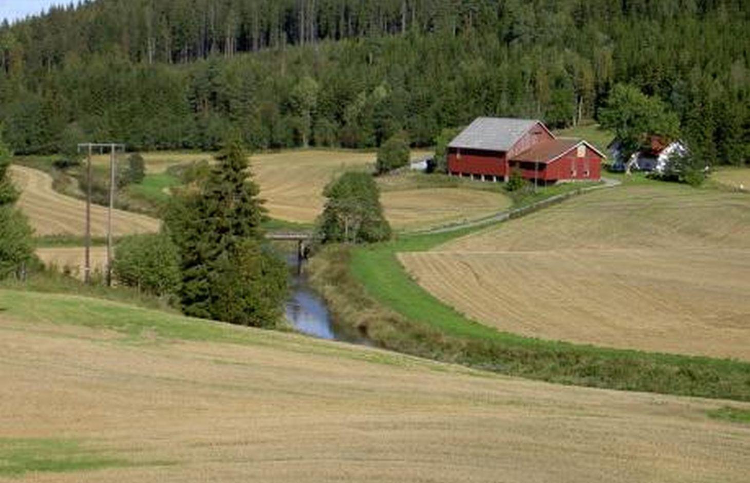
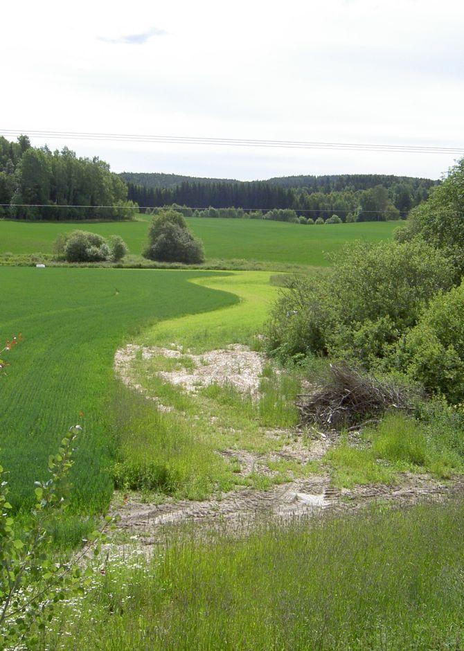
The farmers leave a strip of cropland for grass and herbs to grow along rivers, streams and lakes that intersect their cropland areas. Regulations that origins from the Morsa project (morsa.org) require vegetation zones with a width of approximately eight meters. The establishment of these buffer zones is of high importance in areas regularly exposed to flooding.
Purpose of the Technology: The buffer strips are a measure to slow down surface runoff for more water to infiltrate and for particles carried by the water to settle in the vegetation. It is also meant to contribute to reduce erosion and increase the binding of phosphorous to soil particles, as well as the uptake by the vegetation. A decreased input of particles and nutrients to the cropland waterways is desirable both in order to limit soil loss and to prevent eutrophication of downstream waterbodies.
Establishment / maintenance activities and inputs: To sow grass is recommended when establishing grass covered riparian buffer strips. Robust and dense grass types with a high demand of nutrients are often the most suited for the purpose. The grass strips should generally not be plowed, fertilized or treated by herbicides, but some exceptions may be made. The degree of which it is harvested varies with the grass type and if it is used for animal fodder.
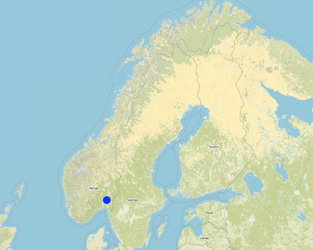
Natural / human environment: The Kråkstad River is mainly situated in Ski commune in Akershus County in South-Eastern parts of Norway. The river catchment is a western tributary of the Vannsjø-Hobøl watercourse, also known as the Morsa watercourse. The Kråkstad River catchment constitutes of a total area of about 22 km², consisting mainly of cropland and forest/woodland. The recipient Vannsjø is a eutrophic lake with a history of algal blooms of e.g. toxic cyanobacterias. The lake is both used as a drinking water source and for recreational purposes, and the Morsa project was established in order to find measures to improve the water quality of Vannsjø.
2.3 Photos of the Technology
Media Gallery
2.5 Country/ region/ locations where the Technology has been applied and which are covered by this assessment
بلد:
Norway
Region/ State/ Province:
Akershus
Further specification of location:
Ski
Comments:
Boundary points of the Technology area: (59.595, 10.896), (59.611, 10.866), (59.670, 10.869), (59.676, 10.849), (59.717, 10.844), (59.723, 10.893), (59.694, 10.969), (59.655, 10.952), (59.668, 10.904), (59.629, 10.915)
Map
×2.6 Date of implementation
If precise year is not known, indicate approximate date:
- 10-50 years ago
2.7 Introduction of the Technology
Specify how the Technology was introduced:
- during experiments/ research
Comments (type of project, etc.):
The Morsa Project (morsa.org)
3. Classification of the SLM Technology
3.2 Current land use type(s) where the Technology is applied

الأراضي الزراعية
- Annual cropping
Main crops (cash and food crops):
Major cash crop annual cropping: Small grain
Major cash crop tree/shrub cropping: Fire wood

Forest/ woodlands
Products and services:
- Fuelwood
Comments:
Major land use problems (compiler’s opinion): Erosion, flooding and landslides, eutrophication of rivers and lakes.
Major land use problems (land users’ perception): Cropland is occupied by the buffer strips, which may lead to decreased production and loss of income.
3.3 Further information about land use
Water supply for the land on which the Technology is applied:
- rainfed
Number of growing seasons per year:
- 1
حددها:
Longest growing period in days: 135Longest growing period from month to month: May to mid September
3.4 SLM group to which the Technology belongs
- cross-slope measure
- surface water management (spring, river, lakes, sea)
3.5 Spread of the Technology
Comments:
Total area covered by the SLM Technology is 4.3 m2.
3.6 SLM measures comprising the Technology

vegetative measures
- V2: Grasses and perennial herbaceous plants
Comments:
Main measures: vegetative measures
3.7 Main types of land degradation addressed by the Technology

soil erosion by water
- Wt: loss of topsoil/ surface erosion
- Wg: gully erosion/ gullying
- Wm: mass movements/ landslides
- Wr: riverbank erosion

water degradation
- Hp: decline of surface water quality
Comments:
Main type of degradation addressed: Wt: loss of topsoil / surface erosion, Hp: decline of surface water quality
Secondary types of degradation addressed: Wg: gully erosion / gullying, Wm: mass movements / landslides, Wr: riverbank erosion
Main causes of degradation: soil management (Use of fertilizer and heavy machinery (compression of the soil and low infiltration rate)), crop management (annual, perennial, tree/shrub), Heavy / extreme rainfall (intensity/amounts) (More flooding and erosion), floods
Secondary causes of degradation: deforestation / removal of natural vegetation (incl. forest fires) (The runoff has a lower retention time in the forest. Leads to higher velocity and more flooding of downstream cropland areas), change of seasonal rainfall (Heavier rainfall events due to climate change), land tenure, governance / institutional
3.8 Prevention, reduction, or restoration of land degradation
Specify the goal of the Technology with regard to land degradation:
- prevent land degradation
- reduce land degradation
Comments:
Main goals: mitigation / reduction of land degradation
Secondary goals: prevention of land degradation
4. Technical specifications, implementation activities, inputs, and costs
4.1 Technical drawing of the Technology
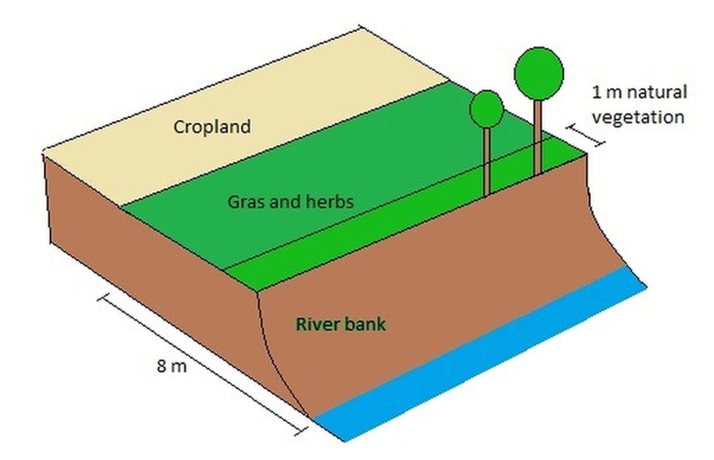
Author:
Kamilla Skaalsveen
4.2 Technical specifications/ explanations of technical drawing
A technical drawing of a grass covered riperian buffer strip with grass cover and riperian vegetation
Technical knowledge required for field staff / advisors: low
Technical knowledge required for land users: low
Main technical functions: control of concentrated runoff: impede / retard
Secondary technical functions: control of raindrop splash, control of dispersed runoff: retain / trap, control of dispersed runoff: impede / retard, control of concentrated runoff: retain / trap, improvement of ground cover, increase of surface roughness, increase of infiltration, increase / maintain water stored in soil, improvement of water quality, buffering / filtering water, sediment retention / trapping, sediment harvesting
Aligned: -along boundary
Vegetative material: T : trees / shrubs
Vegetative measure: Along waterways
Vegetative material: G : grass
Vegetative measure: Vegetative material: G : grass
Vegetative measure: Vegetative material: G : grass
Vegetative measure: Vegetative material: G : grass
Trees/ shrubs species: Naturally
Grass species: Seeded
4.3 General information regarding the calculation of inputs and costs
other/ national currency (specify):
Kroner (NOK)
Indicate exchange rate from USD to local currency (if relevant): 1 USD =:
7,73
Indicate average wage cost of hired labour per day:
827.00
4.4 Establishment activities
| Activity | Type of measure | Timing | |
|---|---|---|---|
| 1. | Plowing | Vegetative | 1 time/yr |
| 2. | Harrowing | Vegetative | 2-3 times/yr |
| 3. | Sawing grass | Vegetative | 2-3 times/yr |
| 4. | Harvesting grass | Vegetative | 2-3 times/yr |
4.5 Costs and inputs needed for establishment
| Specify input | Unit | Quantity | Costs per Unit | Total costs per input | % of costs borne by land users | |
|---|---|---|---|---|---|---|
| Labour | Plowing | zone/farmer/day | 1,0 | 321,0 | 321,0 | 7,0 |
| Labour | Harrowing | zone/farmer/day | 1,0 | 321,0 | 321,0 | 7,0 |
| Labour | Sawing grass | zone/farmer/day | 1,0 | 321,0 | 321,0 | 7,0 |
| Labour | Harvesting grass | zone/farmer/day | 1,0 | 321,0 | 321,0 | 7,0 |
| Total costs for establishment of the Technology | 1284,0 | |||||
4.6 Maintenance/ recurrent activities
| Activity | Type of measure | Timing/ frequency | |
|---|---|---|---|
| 1. | Plowing | Vegetative | Once every 6th year |
| 2. | Harrowing | Vegetative | 2-3 times/yr |
| 3. | Sawing grass | Vegetative | 2-3 times/yr |
| 4. | Harvesting grass | Vegetative | 2-3 times/yr |
4.7 Costs and inputs needed for maintenance/ recurrent activities (per year)
| Specify input | Unit | Quantity | Costs per Unit | Total costs per input | % of costs borne by land users | |
|---|---|---|---|---|---|---|
| Labour | Plowing | zone/farmer/day | 1,0 | 53,0 | 53,0 | 100,0 |
| Labour | Harrowing | zone/farmer/day | 1,0 | 321,0 | 321,0 | |
| Labour | Sawing grass | Day | 1,0 | 321,0 | 321,0 | |
| Labour | Harvesting grass | Day | 1,0 | 321,0 | 321,0 | |
| Total costs for maintenance of the Technology | 1016,0 | |||||
5. Natural and human environment
5.1 Climate
Annual rainfall
- < 250 mm
- 251-500 mm
- 501-750 mm
- 751-1,000 mm
- 1,001-1,500 mm
- 1,501-2,000 mm
- 2,001-3,000 mm
- 3,001-4,000 mm
- > 4,000 mm
Agro-climatic zone
- sub-humid
- semi-arid
Thermal climate class: temperate
Thermal climate class: boreal
5.2 Topography
Slopes on average:
- flat (0-2%)
- gentle (3-5%)
- moderate (6-10%)
- rolling (11-15%)
- hilly (16-30%)
- steep (31-60%)
- very steep (>60%)
Landforms:
- plateau/plains
- ridges
- mountain slopes
- hill slopes
- footslopes
- valley floors
Altitudinal zone:
- 0-100 m a.s.l.
- 101-500 m a.s.l.
- 501-1,000 m a.s.l.
- 1,001-1,500 m a.s.l.
- 1,501-2,000 m a.s.l.
- 2,001-2,500 m a.s.l.
- 2,501-3,000 m a.s.l.
- 3,001-4,000 m a.s.l.
- > 4,000 m a.s.l.
5.3 Soils
Soil depth on average:
- very shallow (0-20 cm)
- shallow (21-50 cm)
- moderately deep (51-80 cm)
- deep (81-120 cm)
- very deep (> 120 cm)
Soil texture (topsoil):
- fine/ heavy (clay)
Topsoil organic matter:
- medium (1-3%)
If available, attach full soil description or specify the available information, e.g. soil type, soil PH/ acidity, Cation Exchange Capacity, nitrogen, salinity etc.
Soil fertility is medium-high
Soil drainage/infiltration is poor
Soil water storage capacity is very low-low
5.4 Water availability and quality
Ground water table:
< 5 m
Availability of surface water:
good
Water quality (untreated):
for agricultural use only (irrigation)
5.5 Biodiversity
Species diversity:
- low
5.6 Characteristics of land users applying the Technology
Market orientation of production system:
- mixed (subsistence/ commercial
- commercial/ market
Off-farm income:
- > 50% of all income
Relative level of wealth:
- average
- rich
Individuals or groups:
- individual/ household
Level of mechanization:
- mechanized/ motorized
Gender:
- women
- men
Indicate other relevant characteristics of the land users:
Land users applying the Technology are mainly common / average land users
Population density: < 10 persons/km2
Annual population growth: < 0.5%
10% of the land users are rich and own 10% of the land.
90% of the land users are average wealthy and own 90% of the land.
5.7 Average area of land owned or leased by land users applying the Technology
- < 0.5 ha
- 0.5-1 ha
- 1-2 ha
- 2-5 ha
- 5-15 ha
- 15-50 ha
- 50-100 ha
- 100-500 ha
- 500-1,000 ha
- 1,000-10,000 ha
- > 10,000 ha
Is this considered small-, medium- or large-scale (referring to local context)?
- medium-scale
5.8 Land ownership, land use rights, and water use rights
Land ownership:
- individual, titled
Land use rights:
- communal (organized)
- individual
Water use rights:
- open access (unorganized)
5.9 Access to services and infrastructure
health:
- poor
- moderate
- good
education:
- poor
- moderate
- good
technical assistance:
- poor
- moderate
- good
employment (e.g. off-farm):
- poor
- moderate
- good
markets:
- poor
- moderate
- good
energy:
- poor
- moderate
- good
roads and transport:
- poor
- moderate
- good
drinking water and sanitation:
- poor
- moderate
- good
financial services:
- poor
- moderate
- good
6. Impacts and concluding statements
6.1 On-site impacts the Technology has shown
Socio-economic impacts
Production
crop production
risk of production failure
production area
Income and costs
expenses on agricultural inputs
farm income
diversity of income sources
workload
Socio-cultural impacts
Improved livelihoods and human well-being
Comments/ specify:
Because of the drinking water quality
Ecological impacts
Water cycle/ runoff
water quality
Soil
soil cover
soil loss
soil crusting/ sealing
soil compaction
nutrient cycling/ recharge
Biodiversity: vegetation, animals
biomass/ above ground C
plant diversity
beneficial species
habitat diversity
6.2 Off-site impacts the Technology has shown
groundwater/ river pollution
buffering/ filtering capacity
6.3 Exposure and sensitivity of the Technology to gradual climate change and climate-related extremes/ disasters (as perceived by land users)
Gradual climate change
Gradual climate change
| Season | Type of climatic change/ extreme | How does the Technology cope with it? | |
|---|---|---|---|
| annual temperature | increase | well |
Climate-related extremes (disasters)
Meteorological disasters
| How does the Technology cope with it? | |
|---|---|
| local rainstorm | not well |
| local windstorm | well |
Climatological disasters
| How does the Technology cope with it? | |
|---|---|
| drought | well |
Hydrological disasters
| How does the Technology cope with it? | |
|---|---|
| general (river) flood | not well |
Other climate-related consequences
Other climate-related consequences
| How does the Technology cope with it? | |
|---|---|
| reduced growing period | well |
6.4 Cost-benefit analysis
How do the benefits compare with the establishment costs (from land users’ perspective)?
Short-term returns:
slightly negative
Long-term returns:
neutral/ balanced
How do the benefits compare with the maintenance/ recurrent costs (from land users' perspective)?
Short-term returns:
slightly negative
Long-term returns:
slightly negative
6.5 Adoption of the Technology
Comments:
Comments on acceptance with external material support: Local regulations determine that farmers only receive subsidies per production area along with financial grants if they implement the technology.
There is no trend towards spontaneous adoption of the Technology
6.7 Strengths/ advantages/ opportunities of the Technology
| Strengths/ advantages/ opportunities in the compiler’s or other key resource person’s view |
|---|
|
The grass catches sediments from the cropland How can they be sustained / enhanced? May be more efficient with a change in grass type (but this is not tested) |
|
Reduced fertilizer usage How can they be sustained / enhanced? Continue in the same way |
|
Corporation between farmers How can they be sustained / enhanced? Joint company for utilizing the buffer strips for grass production |
6.8 Weaknesses/ disadvantages/ risks of the Technology and ways of overcoming them
| Weaknesses/ disadvantages/ risks in the land user’s view | How can they be overcome? |
|---|---|
| Loss of productive cropland | Narrower buffer strips |
| Weaknesses/ disadvantages/ risks in the compiler’s or other key resource person’s view | How can they be overcome? |
|---|---|
| Low infiltration rates | Less heavy machinery on the buffer strips and a wider zone of natural vegetation along the banks |
Links and modules
Expand all Collapse allLinks
No links
Modules
No modules