Community supported pasture and rangeland rehabilitation works [Angola]
- Creation:
- Update:
- Compiler: Nicholas Euan Sharpe
- Editor: Txaran Basterrechea
- Reviewer: Rima Mekdaschi Studer
technologies_3141 - Angola
- Full summary as PDF
- Full summary as PDF for print
- Full summary in the browser
- Full summary (unformatted)
- Community supported pasture and rangeland rehabilitation works: 31 يناير، 2018 (inactive)
- Community supported pasture and rangeland rehabilitation works: 16 فبراير، 2018 (inactive)
- Community supported pasture and rangeland rehabilitation works: 6 مارس، 2019 (inactive)
- Community supported pasture and rangeland rehabilitation works: 2 نوفمبر، 2021 (public)
View sections
Expand all Collapse all1. معلومات عامة
1.2 Contact details of resource persons and institutions involved in the assessment and documentation of the Technology
SLM specialist:
Name of project which facilitated the documentation/ evaluation of the Technology (if relevant)
Reabilitação de terras e gestão das áreas de pastagem nos sistemas de produção agro-pastoris dos pequenos produtores no sudoeste de Angola (RETESA)Name of the institution(s) which facilitated the documentation/ evaluation of the Technology (if relevant)
FAO Angola (FAO Angola) - Angola1.3 Conditions regarding the use of data documented through WOCAT
When were the data compiled (in the field)?
15/05/2017
The compiler and key resource person(s) accept the conditions regarding the use of data documented through WOCAT:
نعم
1.4 Declaration on sustainability of the described Technology
Is the Technology described here problematic with regard to land degradation, so that it cannot be declared a sustainable land management technology?
لا
2. Description of the SLM Technology
2.1 Short description of the Technology
Definition of the Technology:
The technology was developed and used to select key pasture and fodder species and reintroduce them into strategic areas through stakeholder participation. The technology was also supported by communal management plans were created to address root causes of land degradation.
2.2 Detailed description of the Technology
Description:
The technology was developed and implemented through the RETESA Project “Land rehabilitation and rangelands management in smallholders agro-pastoral production systems in south western Angola”, which is a project owned and implemented by the Ministry of Environment of the Government of Angola with technical and methodological assistance from The Food and Agriculture Organization of the United Nations (FAO) and financed by the Global Environmental Found (GEF).
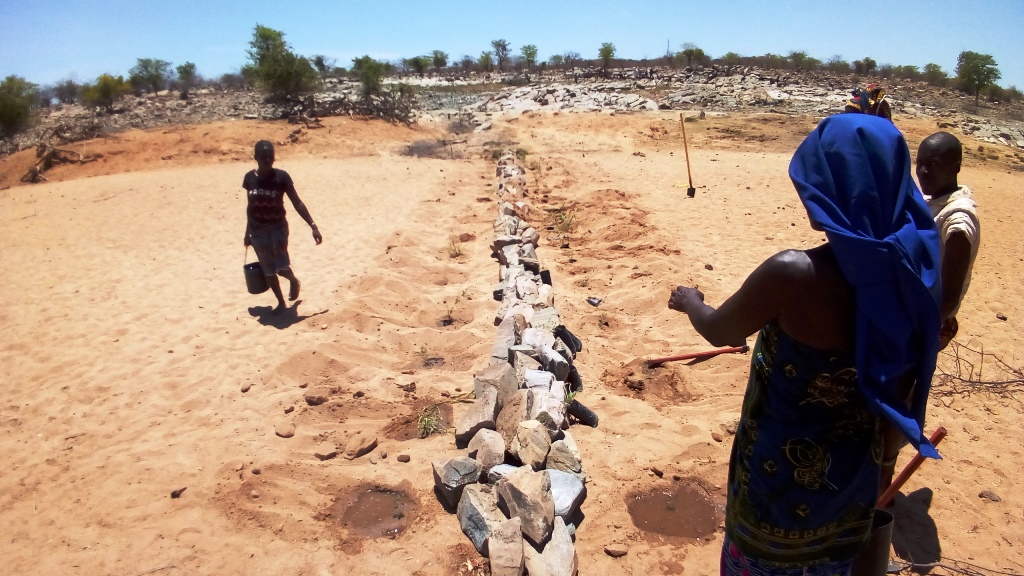
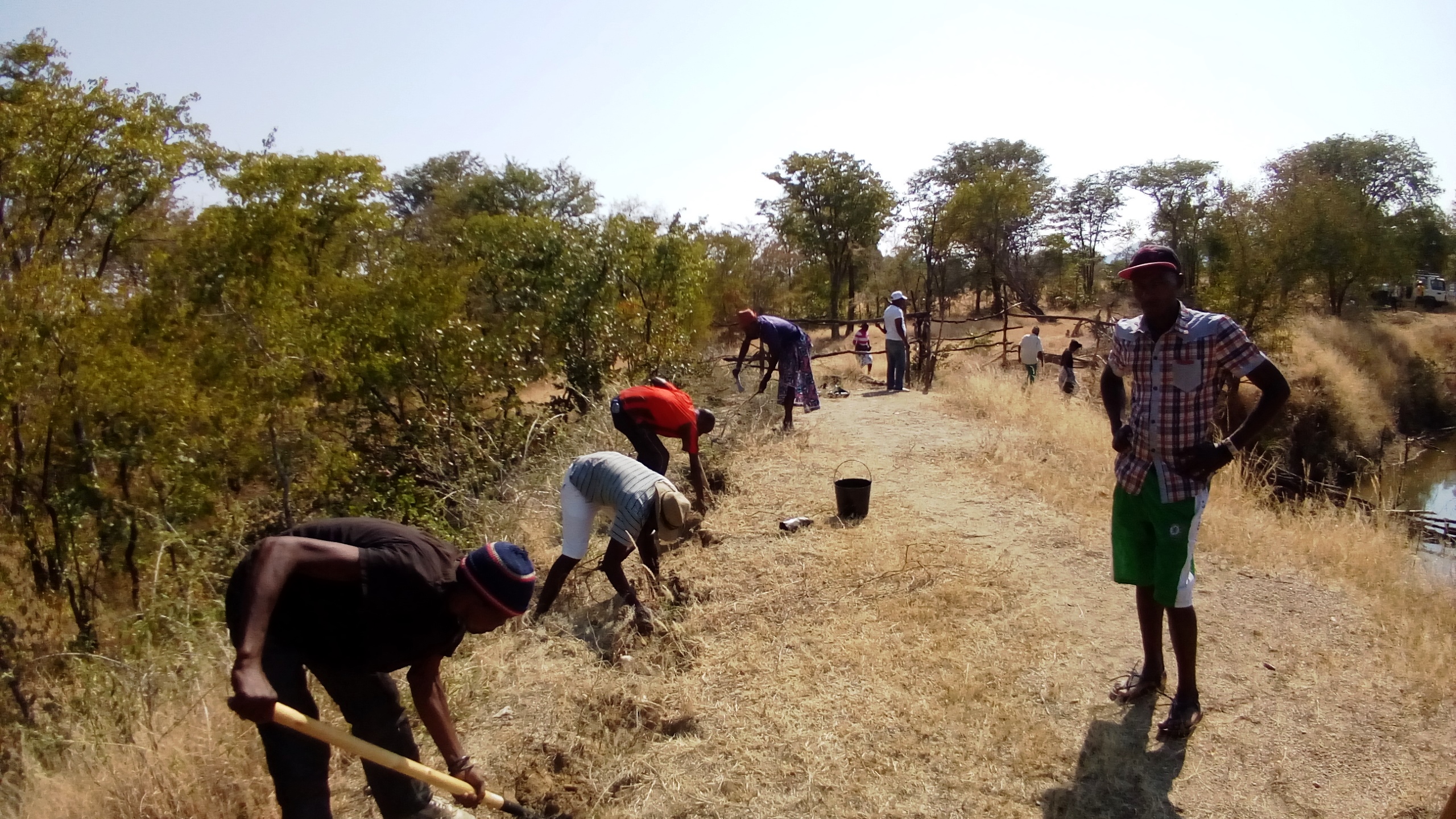
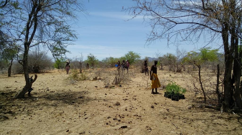
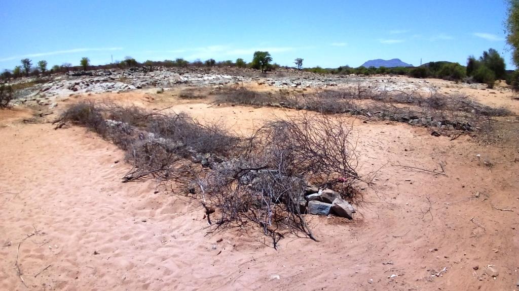
Improper grazing regimes and animal management on part of pastoral communities in SW Angola have led to degradation of rangeland and pastoral resources, with perennial grassland species and shrubs having been effectively eliminated from lowland grazing areas. The pastoral communities of the area know their environment extremely well and are aware of the land degradation happening around them. They identified crucial areas for the rehabilitation works, selecting mostly areas around water points that were used both by local and transhumant herders. Through these works, the locals sought to increase ground cover to reduce sediment loads entering waterways (erosion control), provide shade for livestock, increase forage production and introduce legumes and multiuse forage trees in areas of high animal traffic. A total of 4 areas in the Bibala and Virei Municipalities were identified for the activities.
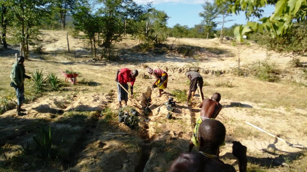
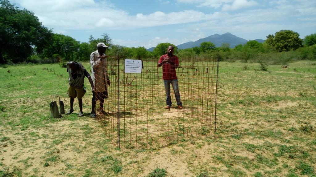
The communities were heavily involved in the selection and propagation of plant species for the rehabilitation works. The project field staff also ran participatory, field palatability trials with them to confirm the plants selected met their expectations and to enhance their understanding of livestock nutrition and how it related to animal health. Once the species were chosen, seed was collected by the communities and the Project Technicians and was multiplied in 32 Agro-Pastoral Field School Nurseries and 2 Government funded Veterinary Research Stations. A total of 15 species were identified, with Eragrostis superba, Urochloa mosambicensis, Acacia nilotica, Faidherbia albida, Leucaena leucocephala and Moringa oleifera being the most valued by the communities as forage and multiuse species. Trees and shrubs were germinated from seed with success. As their seeds failed to germinate by standard methods, native grass species were multiplied by root divisions of plants collected in cultivated fields so as not to remove any from natural areas. Early field trials ruled out direct seeding methods.
As the majority of areas selected for the rehabilitation works were focused around water points and waterways, the soils were generally alluvial, sandy loams. Precipitation is highest in the areas to the north, ranging from 600mm in the upper areas of the Bibala Municipality to 200mm in the areas to the south in Virei. In general, the vegetation communities could be described as dry sclerophyll woodlands with Colophospermum mopane being the dominant tree species, with forest cover decreasing in height and density as one moves south toward drier areas.
Through close collaboration with the participant communities, 3 rehabilitation methods were designed and improved upon throughout the Project's duration. Method 1 was used to plant open areas within the rehabilitation zone, Method 2 was used to introduce and protect concentrated plantings of the selected species in strategic locations within the landscape and Method 3 was used to recuperate riparian vegetation and reduce sediment loads in waterways. The 3 Methods used are described in more detail in the Technical Drawing on page 3. To increase appropriation and increase the effectiveness of the rehabilitation works, land management plans and other supporting activities were also carried out.
2.3 Photos of the Technology
Media Gallery
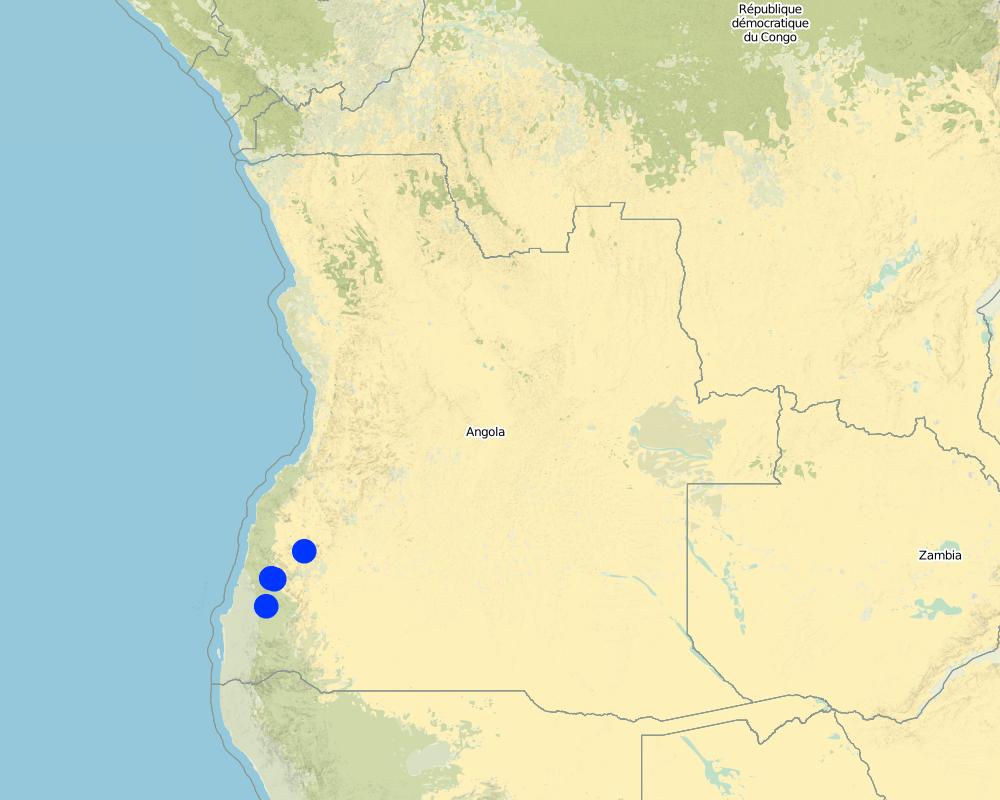
2.5 Country/ region/ locations where the Technology has been applied and which are covered by this assessment
بلد:
Angola
Region/ State/ Province:
Province of Namibe
Further specification of location:
Municipalities of Bibala and Virei
Comments:
There are 3 main rehabilitation areas, all within the Namibe Province in Southern Angola.
Map
×2.6 Date of implementation
If precise year is not known, indicate approximate date:
- less than 10 years ago (recently)
2.7 Introduction of the Technology
Specify how the Technology was introduced:
- through projects/ external interventions
Comments (type of project, etc.):
The proposed project: “Land rehabilitation and rangelands management in smallholders’ agropastoral production systems in southwestern Angola” (RETESA) is a joint effort by the Ministério do Ambiente (MA), Ministério da Agricultura e do Desenvolvimento Rural e das Pescas (MINANDER), Governo Provincial do Namibe, Governo Provincial do Huila, and Governo Provincial de Benguela, together with FAO and GEF. In line with the GEF-5 Land Degradation strategy, the project’s goal is to create an enhanced enabling environment in the agricultural sector and a sustained flow of agro-ecosystem services.
3. Classification of the SLM Technology
3.1 Main purpose(s) of the Technology
- improve production
- reduce, prevent, restore land degradation
- conserve ecosystem
- preserve/ improve biodiversity
- reduce risk of disasters
- adapt to climate change/ extremes and its impacts
- mitigate climate change and its impacts
- create beneficial economic impact
3.2 Current land use type(s) where the Technology is applied

أراضي الرعي
Extensive grazing land:
- Semi-nomadism/ pastoralism
- Transhumance movements
Main animal species and products:
Cattle and goats.
Milk and meat.

Waterways, waterbodies, wetlands
- Drainage lines, waterways
- Ponds, dams
- Natural springs
If land use has changed due to the implementation of the Technology, indicate land use before implementation of the Technology:
Cropping land is increasing in the area as population rates increase and locals move towards more sedimentary livelihoods.
3.3 Further information about land use
Water supply for the land on which the Technology is applied:
- rainfed
Number of growing seasons per year:
- 1
Livestock density (if relevant):
Official data is not available and true livestock numbers are unknown.
3.4 SLM group to which the Technology belongs
- pastoralism and grazing land management
- improved ground/ vegetation cover
3.5 Spread of the Technology
Specify the spread of the Technology:
- applied at specific points/ concentrated on a small area
Comments:
Plantings areas are selected due to their importance and relevance to the local communities. For the most part, the plantings have been centred around key water points. In order to increase impact and scale up the process of rangeland rehabilitation and improvement, management plans are negotiated and agreed upon by the communities through the Green Negotiated Territorial Development Approach (GreeNTD) processes.
3.6 SLM measures comprising the Technology

vegetative measures
- V1: Tree and shrub cover
- V2: Grasses and perennial herbaceous plants

management measures
- M2: Change of management/ intensity level
Comments:
The management plans created at the community and administrative level identify a number of large areas which are to serve as 'Grazing Reverses' for the dry season. Therefore, the agreements call for all livestock to abandon the area at the onset of the first rains and not return until the Pastoral Management Forum agrees to open the area for grazing. Once open, the range is available to all pastoralists, those that live in the immediate area and those moving through on their transhumance migration.
3.7 Main types of land degradation addressed by the Technology

soil erosion by water
- Wt: loss of topsoil/ surface erosion
- Wr: riverbank erosion

biological degradation
- Bc: reduction of vegetation cover
- Bh: loss of habitats
- Bq: quantity/ biomass decline
- Bs: quality and species composition/ diversity decline
- Bl: loss of soil life
3.8 Prevention, reduction, or restoration of land degradation
Specify the goal of the Technology with regard to land degradation:
- reduce land degradation
- restore/ rehabilitate severely degraded land
4. Technical specifications, implementation activities, inputs, and costs
4.1 Technical drawing of the Technology
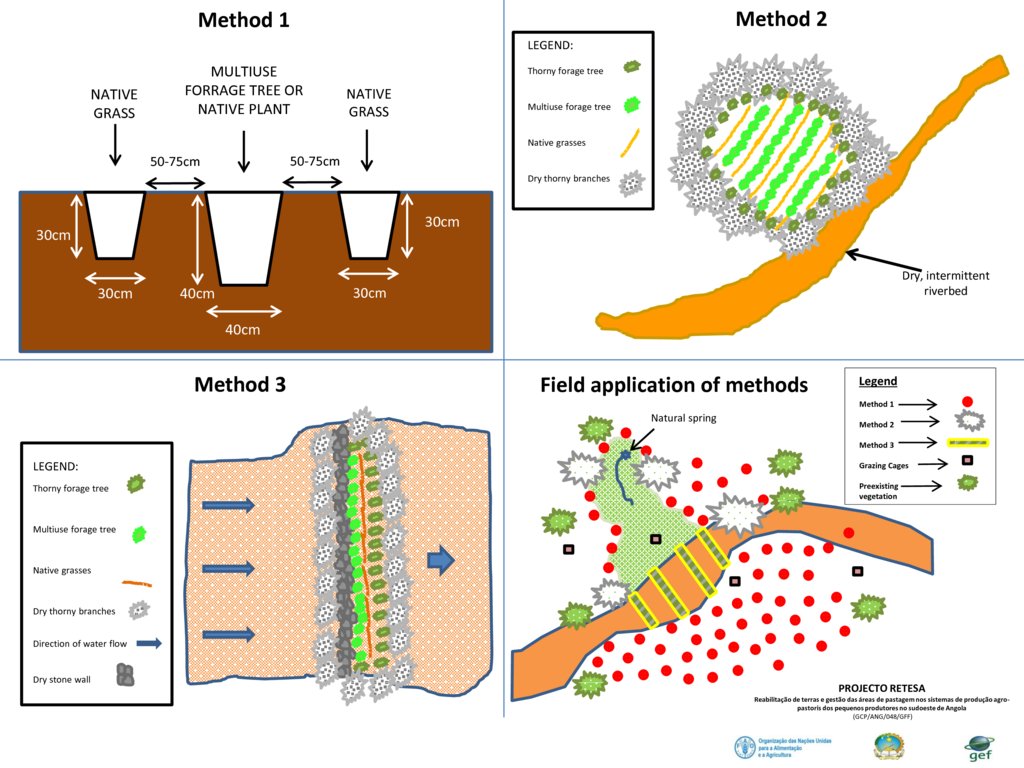
Author:
Projecto RETESA
Date:
10/01/2018
4.2 Technical specifications/ explanations of technical drawing
Plantings are typically based on 3 established methods, as seen in the exemples provided.
- Method 1 relies on placing a leguminous, multiuse tree species in the ground with two native grass species to each side of the tree. The holes are dug and a small amount of manure is placed in the bottom of the hole, adding some water to the hole if it is readily available. Then the trees and grasses are planted and well watered. Finally, a branch or two of thorny shrubs or trees are placed over the plants to protect them from grazing (where possible, attempts are made to use thorny branches that were already dead or had fallen).
- Method 2 requires the creation of an enclosed, protected area which is then planted in high densities, preferably in low-lying areas where soil moisture is available to support such high concentrations of plants. Dry, dead branches from thorny trees and shrubs were used to create the enclosures and provide protection to these plantings.
- Method 3 is based on the creation of a 'Leaky weir', which is a small stone barrier planted with a mixture of native riparian species placed horizontally to the flow of water. It is intended to slow the flow of water and allow for the recovery of riparian vegetation. The plants are also protected with dry, dead branches from thorny trees and shrubs in this method.
To increase their effectiveness, it is recommended that the 3 methods be combined within the landscape, as seen in the 4th slide 'Field application of methods'.
4.3 General information regarding the calculation of inputs and costs
Specify how costs and inputs were calculated:
- per Technology unit
Specify unit:
3345 seedlings produced, delivered and planted
Specify volume, length, etc. (if relevant):
3345 units
Specify currency used for cost calculations:
- US Dollars
Indicate average wage cost of hired labour per day:
6 Dollars
4.4 Establishment activities
| Activity | Type of measure | Timing | |
|---|---|---|---|
| 1. | Meetings and field visits with participant communities to identify plant species and their uses | Other measures | Best during growing season |
| 2. | Further meetings to decide on which species are to be multiplied and arrange seed collection | Other measures | Near end of growing season |
| 3. | Seed collection and transportation | Other measures | When seed is available (varies with species) |
| 4. | Instalation of irrigation systems | Structural | Most communiites need a water extraction and distribution system to create nurseries |
| 5. | Delivery of nursery supplies and instalation of shade cloth | Structural | Nurseries should have water access and shade |
| 6. | Planting of seeds and care for seedlings at nursery | Vegetative | Formed part of Agro-Pastoral Farmer Field School activities |
| 7. | Identification of planting areas and timing | Other measures | Should be at beginning of rainy season, or when soil moisture permits |
| 8. | Organisation of materials and tools | Other measures | At least 1 week before the planting |
| 9. | Planting day (preparation of planting holes and transplanting of seedlings) | Vegetative | 2 days maximum was seen to be optimal |
| 10. | Watering until the plants are established | Agronomic | Usually a maximum of 3 watering over 1 week after the plantings |
| 11. | Follow up visits to make sure management agreements are being respected and plants are not being eaten by stock until they are ready | Management | Plants should not be grazed for at least 6 months from planting time until they are well established |
Comments:
The activities and costs given were those needed to produce and plant 3,345 trees and grasses in the 4 rehabilitation areas. Given that 3.345 plants were produced at a cost of $3284.75, the cost per plant produced and planted in the field is $0.98. As the inputs and materials for the 3 methods came from the same source and the methods were implemented together at the same time, no distinction of the costs for each method is avaliable, though the labour and materials are similar enough so that they one could assign the same costs for the 3.
As per the question of planting densities, they are often dependent on numerous factores but one can easily calculate the costs per hectare by knowing plant densities and deducing the costs.
4.5 Costs and inputs needed for establishment
| Specify input | Unit | Quantity | Costs per Unit | Total costs per input | % of costs borne by land users | |
|---|---|---|---|---|---|---|
| Labour | Project Technicians/Drivers/Consultants, etc | Person-days | 30,0 | 20,0 | 600,0 | |
| Labour | Plant identification activities and seed collection | Person-days | 10,0 | 6,0 | 60,0 | 100,0 |
| Labour | Plant nursery creation and plant production | Person-days | 16,0 | 6,0 | 96,0 | 100,0 |
| Labour | Participation during planting days | Person-days | 25,0 | 10,0 | 250,0 | 90,0 |
| Equipment | Vehicle | Trips | 10,0 | 40,0 | 400,0 | |
| Equipment | Nursery supplies (including water system which also supplies water to Farmer Field School) | Materials | 1,0 | 800,0 | 800,0 | 10,0 |
| Equipment | Planting supplies (shovels, hoes, wheelbarrows, etc.) | Materials | 1,0 | 120,0 | 120,0 | |
| Equipment | Other improvements to water point (fencing, cement blocks, cement, hoses, etc.) | Materials | 1,0 | 250,0 | 250,0 | |
| Equipment | Maps (traced onto paper from projected images for management purposes) | Materials | 1,0 | 10,0 | 10,0 | |
| Equipment | Food and Refreshments | Per person | 25,0 | 2,5 | 62,5 | |
| Fertilizers and biocides | Manure (50 grams per sack, 12.500 sacks) | Kilos | 625,0 | 0,25 | 156,25 | 100,0 |
| Construction material | Shade-cloth | m2 | 320,0 | 1,5 | 480,0 | |
| Total costs for establishment of the Technology | 3284,75 | |||||
If land user bore less than 100% of costs, indicate who covered the remaining costs:
Remaining costs were provided by the RETESA Project.
Comments:
Production depends on the ability of the pastoral communities to produce viable plants. If they are unable to do so, then plants can be bought from Government funded nurseries, though costs per plant will most rise though it can substitute the need for having to purchase a water supply system. The total shown here reflects a percentage (16%) of the costs of installing a water system that supplied water to the whole of the Agro-Pastoral Farmer Field School. These systems usually included a 10,000 litre water tank, a gasoline water pump, extraction pipe and parts, 100 to 200 mts of 1.5" hoses and parts and 3 kms of drip irrigation hose.
4.6 Maintenance/ recurrent activities
| Activity | Type of measure | Timing/ frequency | |
|---|---|---|---|
| 1. | Meetings to ensure management agreements are being respected. | Management | Once every 3 to 6 months, especially before and after rainy season. |
| 2. | Repairs and replacement of nursery supplies. | Structural | Once a year. |
| 3. | Replanting of dead seedlings | Vegetative | Just before and during rainy season. |
4.7 Costs and inputs needed for maintenance/ recurrent activities (per year)
| Specify input | Unit | Quantity | Costs per Unit | Total costs per input | % of costs borne by land users | |
|---|---|---|---|---|---|---|
| Labour | Visits to sites and tour of planting areas. | Person-days | 4,0 | 20,0 | 80,0 | 50,0 |
| Labour | Driver. | Person-days | 1,0 | 20,0 | 20,0 | |
| Labour | Replanting of dead seedlings | Person-days | 2,0 | 6,0 | 12,0 | 100,0 |
| Labour | Watering | Person-days | 14,0 | 6,0 | 84,0 | 100,0 |
| Equipment | Vehicle | Trips | 1,0 | 40,0 | 40,0 | |
| Equipment | Watering cans and buckets | Materials | 4,0 | 5,0 | 20,0 | |
| Total costs for maintenance of the Technology | 256,0 | |||||
If land user bore less than 100% of costs, indicate who covered the remaining costs:
The RETESA Project provided an important part of both material and technical support to the communities, though the communities also contributed substantially.
4.8 Most important factors affecting the costs
Describe the most determinate factors affecting the costs:
The activities and costs given were those needed to produce and plant 3,345 trees and grasses in the 4 rehabilitation areas. Given that 3.345 plants were produced at a cost of $3284.75, the cost per plant produced and planted in the field is $0.98. Seedlings avaliable through local, government nurseries were $2.00 per unit, but only exotic ornamentals were avaliable. However, it can be expected that in other contexts and locations, it would be cheaper to buy seedlings instead of training communities and creating numerous small scale nurseries, though clearly these communities will not appropriate the process as well as if they were involved from the beginning.
5. Natural and human environment
5.1 Climate
Annual rainfall
- < 250 mm
- 251-500 mm
- 501-750 mm
- 751-1,000 mm
- 1,001-1,500 mm
- 1,501-2,000 mm
- 2,001-3,000 mm
- 3,001-4,000 mm
- > 4,000 mm
Specifications/ comments on rainfall:
In the past, the rainy season started in October or November and ran until May. However, the rains in the last few years have fallen in January to April.
Indicate the name of the reference meteorological station considered:
None in the area.
Agro-climatic zone
- semi-arid
5.2 Topography
Slopes on average:
- flat (0-2%)
- gentle (3-5%)
- moderate (6-10%)
- rolling (11-15%)
- hilly (16-30%)
- steep (31-60%)
- very steep (>60%)
Landforms:
- plateau/plains
- ridges
- mountain slopes
- hill slopes
- footslopes
- valley floors
Altitudinal zone:
- 0-100 m a.s.l.
- 101-500 m a.s.l.
- 501-1,000 m a.s.l.
- 1,001-1,500 m a.s.l.
- 1,501-2,000 m a.s.l.
- 2,001-2,500 m a.s.l.
- 2,501-3,000 m a.s.l.
- 3,001-4,000 m a.s.l.
- > 4,000 m a.s.l.
Indicate if the Technology is specifically applied in:
- not relevant
Comments and further specifications on topography:
Usually the plantings are undertaken along river plains and river banks, as they are the only areas that have the necessary soil moisture to ensure survival of the seedlings.
5.3 Soils
Soil depth on average:
- very shallow (0-20 cm)
- shallow (21-50 cm)
- moderately deep (51-80 cm)
- deep (81-120 cm)
- very deep (> 120 cm)
Soil texture (topsoil):
- coarse/ light (sandy)
Soil texture (> 20 cm below surface):
- coarse/ light (sandy)
Topsoil organic matter:
- low (<1%)
5.4 Water availability and quality
Ground water table:
< 5 m
Availability of surface water:
poor/ none
Water quality (untreated):
poor drinking water (treatment required)
Is water salinity a problem?
نعم
حددها:
Many bores and wells cannot be used due to Salinity problems. Before planting, it is wise to make sure soil salinity is not problematic in areas identified.
Is flooding of the area occurring?
نعم
Regularity:
episodically
Comments and further specifications on water quality and quantity:
Water quality and quantity are major issues for the area. There are few if any reliable water sources in the area and most communities depend on wells dug in the river bottoms to supply their water.
5.5 Biodiversity
Species diversity:
- medium
Habitat diversity:
- low
Comments and further specifications on biodiversity:
The area is devoid of most wild animals due to the years of war the country experienced during the second half of the 20th century.
5.6 Characteristics of land users applying the Technology
Sedentary or nomadic:
- Semi-nomadic
Market orientation of production system:
- subsistence (self-supply)
Off-farm income:
- 10-50% of all income
Relative level of wealth:
- very poor
Individuals or groups:
- individual/ household
Level of mechanization:
- manual work
Gender:
- women
- men
Age of land users:
- youth
- middle-aged
Indicate other relevant characteristics of the land users:
The communities are still traditional though are currently being influenced by the globalisation process.
5.7 Average area of land owned or leased by land users applying the Technology
- < 0.5 ha
- 0.5-1 ha
- 1-2 ha
- 2-5 ha
- 5-15 ha
- 15-50 ha
- 50-100 ha
- 100-500 ha
- 500-1,000 ha
- 1,000-10,000 ha
- > 10,000 ha
Is this considered small-, medium- or large-scale (referring to local context)?
- large-scale
Comments:
Agricultural plots are considered private and are usually between 1 to 2 hectares, though grazing land, which makes up the majority of the area, is still commonly owned and coveres vast areas.
5.8 Land ownership, land use rights, and water use rights
Land ownership:
- communal/ village
Land use rights:
- open access (unorganized)
Water use rights:
- open access (unorganized)
5.9 Access to services and infrastructure
health:
- poor
- moderate
- good
education:
- poor
- moderate
- good
technical assistance:
- poor
- moderate
- good
employment (e.g. off-farm):
- poor
- moderate
- good
markets:
- poor
- moderate
- good
energy:
- poor
- moderate
- good
roads and transport:
- poor
- moderate
- good
drinking water and sanitation:
- poor
- moderate
- good
financial services:
- poor
- moderate
- good
6. Impacts and concluding statements
6.1 On-site impacts the Technology has shown
Socio-economic impacts
Production
fodder production
Quantity before SLM:
Low rangeland production
Quantity after SLM:
Slight improvement
Comments/ specify:
Difficult to measure. Rehabilitation works and the management plans for the rangeland areas have led to some improvement though the droughts affecting the area during the interventions significantly affected rangeland fodder production.
fodder quality
Quantity before SLM:
No crop residues or fodder plantings used
Quantity after SLM:
Crop residues and fodder plantings incorporated in cropping areas
Comments/ specify:
The process allowed Project Technicians to educate communities on the use of crop residues as fodder and the planting of multiuse trees within cropping areas to provide green fodder in the dry season. The reintroduction of drought tolerante, quality native grasses should also lead an increase in fodder production over the coming year.
animal production
Quantity before SLM:
No planning for dry season grazing, apart from transhumance movements
Quantity after SLM:
Crop residues and other cultivated forages produced for those animals that stay
Comments/ specify:
The transhumance movements of livestock are still seen as the most adequate solution to changes in natural rangeland production though most families leave behind some animals with the main family unit. These animals are now receiving the quality feed they need to remain productive and healthy.
land management
Quantity before SLM:
No management plans in place for commonly managed natural resources
Quantity after SLM:
Participatory land management plans have been negociated and agreed
Comments/ specify:
Simplied land management plans based on traditional livestock movements and cropping seasons have been negotiated and agreed upon by local stakeholders and municipal Administrators.
Water availability and quality
drinking water quality
Quantity before SLM:
Livestock and communities drink from same water
Quantity after SLM:
Separate water drinking points for livestock and community
Comments/ specify:
Unrestricted access of livestock to community domestic water points led to waterborne diseases and poor water quality. Separating livestock and domestic use has improved community health.
water availability for livestock
Comments/ specify:
In addition to restricting livestock access to main water bodies, new drinking troughs have been built with community support.
water quality for livestock
Comments/ specify:
By separating livestock drinking points and domestic water points, waterborne illnesses have been reduced. In at least one area a water tank and new drinking trough have been built with community support.
Socio-cultural impacts
SLM/ land degradation knowledge
Quantity before SLM:
No education or training on land degradation
Quantity after SLM:
Education and training on land degradation issues and rehabilitation methods
Comments/ specify:
The majority of communities that have gone through the process now understand how improper land management leads to land degradation and steps they can take to reduce it.
Ecological impacts
Water cycle/ runoff
water quantity
Comments/ specify:
Improved ground cover and the return of riparian vegetation would increase infiltration rates and decrease evapotranspiration rates and restore the small water cycle. But this is also a long term process.
water quality
Quantity before SLM:
Low
Quantity after SLM:
Low in short term, improved in long term
Comments/ specify:
Revegetation of river plains and river banks should led to improved water quality though it will be a long term effect if the rehabilitation areas are respected.
surface runoff
Quantity before SLM:
No method to deal with the high surface runoff rates in the area
Quantity after SLM:
A method has been devised for reducing surface runoff rates.
Comments/ specify:
The 'Leaky weir' method (Rehabilitation method 3) has shown promise over the duration of the Project and could be applied at other landscape levels to reduce surface runoff.
Soil
soil cover
Comments/ specify:
The reintroduction of native grasses in the area should lead to improved ground cover ratios.
soil loss
Comments/ specify:
The reintroduction of native grasses in the area should lead to improved ground cover ratios, binding the soil and reducing erosion rates.
nutrient cycling/ recharge
Comments/ specify:
Proper livestock management also ensures that manure is properly and evenly distributed in the field.
Biodiversity: vegetation, animals
Vegetation cover
Quantity before SLM:
Reduced number of poor quality grass species
Quantity after SLM:
Communities capacitated in plant multiplication methods
Comments/ specify:
Apart from the rehabilitation works themselves, the local communities have been capacitated with methods to approach and deal with land degradation.
biomass/ above ground C
plant diversity
Comments/ specify:
The reintroduction of native and legumous plants has improved plant diversity both within rehabilitation areas and cultived lands.
Climate and disaster risk reduction
drought impacts
micro-climate
Comments/ specify:
The works around the water points over time should lead to increase in vegetative cover, shade, habitat and reduced temperatures.
6.2 Off-site impacts the Technology has shown
buffering/ filtering capacity
6.3 Exposure and sensitivity of the Technology to gradual climate change and climate-related extremes/ disasters (as perceived by land users)
Gradual climate change
Gradual climate change
| Season | Type of climatic change/ extreme | How does the Technology cope with it? | |
|---|---|---|---|
| annual rainfall | decrease | well | |
| seasonal rainfall | spring | decrease | well |
6.4 Cost-benefit analysis
How do the benefits compare with the establishment costs (from land users’ perspective)?
Short-term returns:
neutral/ balanced
Long-term returns:
positive
How do the benefits compare with the maintenance/ recurrent costs (from land users' perspective)?
Short-term returns:
neutral/ balanced
Long-term returns:
positive
6.5 Adoption of the Technology
- single cases/ experimental
Of all those who have adopted the Technology, how many have did so spontaneously, i.e. without receiving any material incentives/ payments?
- 0-10%
6.6 التكيف
Has the Technology been modified recently to adapt to changing conditions?
لا
6.7 Strengths/ advantages/ opportunities of the Technology
| Strengths/ advantages/ opportunities in the land user’s view |
|---|
| Communities learn about plants' role in the wider ecosystem, how to select and multiply key fruit, fodder or timber species and should see an increase in their horticultural and livestock production, leading to improved nutrition or income. |
| Done properly, it can be a cost-effective and reliable way to produce the plants needed within family units. |
| Strengths/ advantages/ opportunities in the compiler’s or other key resource person’s view |
|---|
| When the plants are produced in collaboration with the local pastoral communities, the benefits are wide ranging, promoting everything from environmental awareness to technical and practical knowledge. |
| It remains a cost effective way of improving key productive species and increasing community resilence. |
| Increasing biomass and introducing better management cycles contribute to reducing land degradation and improve nutrient and energy cycling. |
6.8 Weaknesses/ disadvantages/ risks of the Technology and ways of overcoming them
| Weaknesses/ disadvantages/ risks in the land user’s view | How can they be overcome? |
|---|---|
| Can require stable supply of water, and labour costs can increase if water sources are not easily accessible. | Locate nurseries near reliable and accessible water sources. |
| Can require permanent residence, so as to be able to care for plants until they are developed and placed in the ground at the proper date in the calendar (before or during rainy season). | Not easy in nomadic cultures. |
| Early attempts often fail to produce lasting results. | Concentrate early efforts on small experimental plots so as to fine-tune planting methods and timing. |
| Weaknesses/ disadvantages/ risks in the compiler’s or other key resource person’s view | How can they be overcome? |
|---|---|
| The technology is usually not suitable for large areas of land (>1,000 hectares). | Compliment any rehabilitation efforts with improved management plans which are developed with stakeholder input and approval. |
| Plant losses are typically high, especially if rains fail to arrive, or if the year is abnormally dry. | Watch weather forecast to try and focus planting campaigns on those days with a high probability of rain. |
| Local species are often not valued by local officials and technicians, leading to a predominance of exotic species in rehabilitation works. | Undertake awareness and training sessions which highlight the value and uses of native species with local land users and administrative officials. |
7. References and links
7.1 Methods/ sources of information
- field visits, field surveys
The Project has a number of activities in the communities where the technology was used so there were numerous visits and interviews.
- interviews with land users
Various information and survey methods were used throughout the RETESA Project, providing a solid basis from which to involve landusers and SLM specialists in decisionmaking processes.
- interviews with SLM specialists/ experts
3 SLM specialists.
7.3 Links to relevant information which is available online
Title/ description:
FAO in Action: Using indigenous knowledge to reverse land degradation in Angola.
URL:
http://www.fao.org/in-action/using-indigenous-knowledge-to-reverse-land-degradation-in-angola/en/
Links and modules
Expand all Collapse allLinks
No links
Modules
No modules