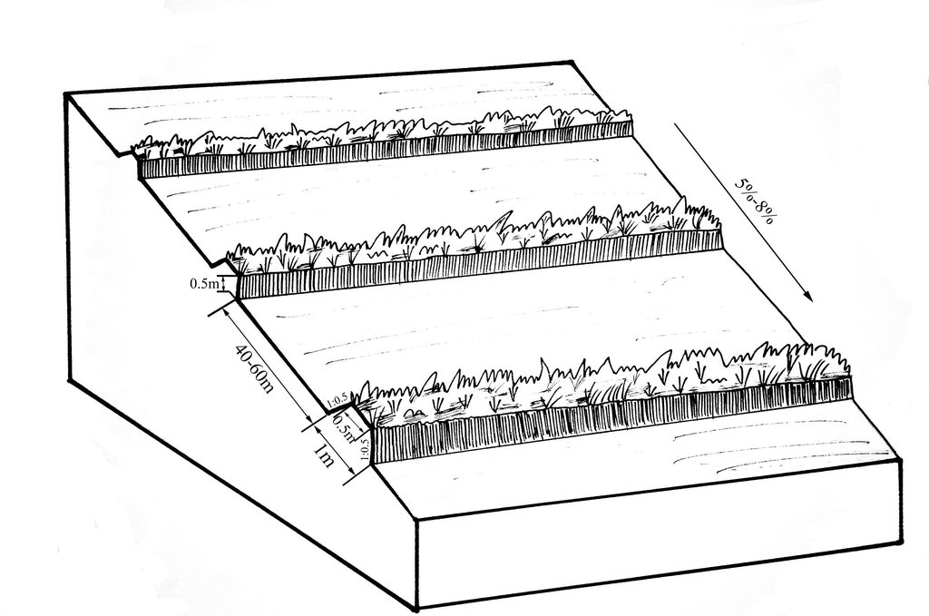
Shrubbery buffer strip with bund [الصين]
- تاريخ الإنشاء:
- تحديث:
- جامع المعلومات: Mei Zhao
- المحرر: –
- المراجعون: David Streiff, Alexandra Gavilano
Grass Buffer Strip
technologies_1544 - الصين
عرض الأقسام
توسيع الكل طي الكل1. معلومات عامة
1.2 تفاصيل الاتصال بالأشخاص الرئيسيين لمصدر المعلومات والمؤسسات المشاركة في تقييم وتوثيق التقنية
متخصص في الإدارة المستدامة للأراضي:
1.3 الشروط المتعلقة باستخدام البيانات الموثقة من خلال WOCAT
يوافق جامع المعلومات والشخص (لاشخاص) الرئيسي لمصدر المعلومات على الشروط المتعلقة باستخدام البيانات الموثقة من خلال WOCAT:
نعم
2. وصف تقنيةالإدارة المستدامي للأراضي
2.1 وصف مختصر للتقنية
تعريف التقنية:
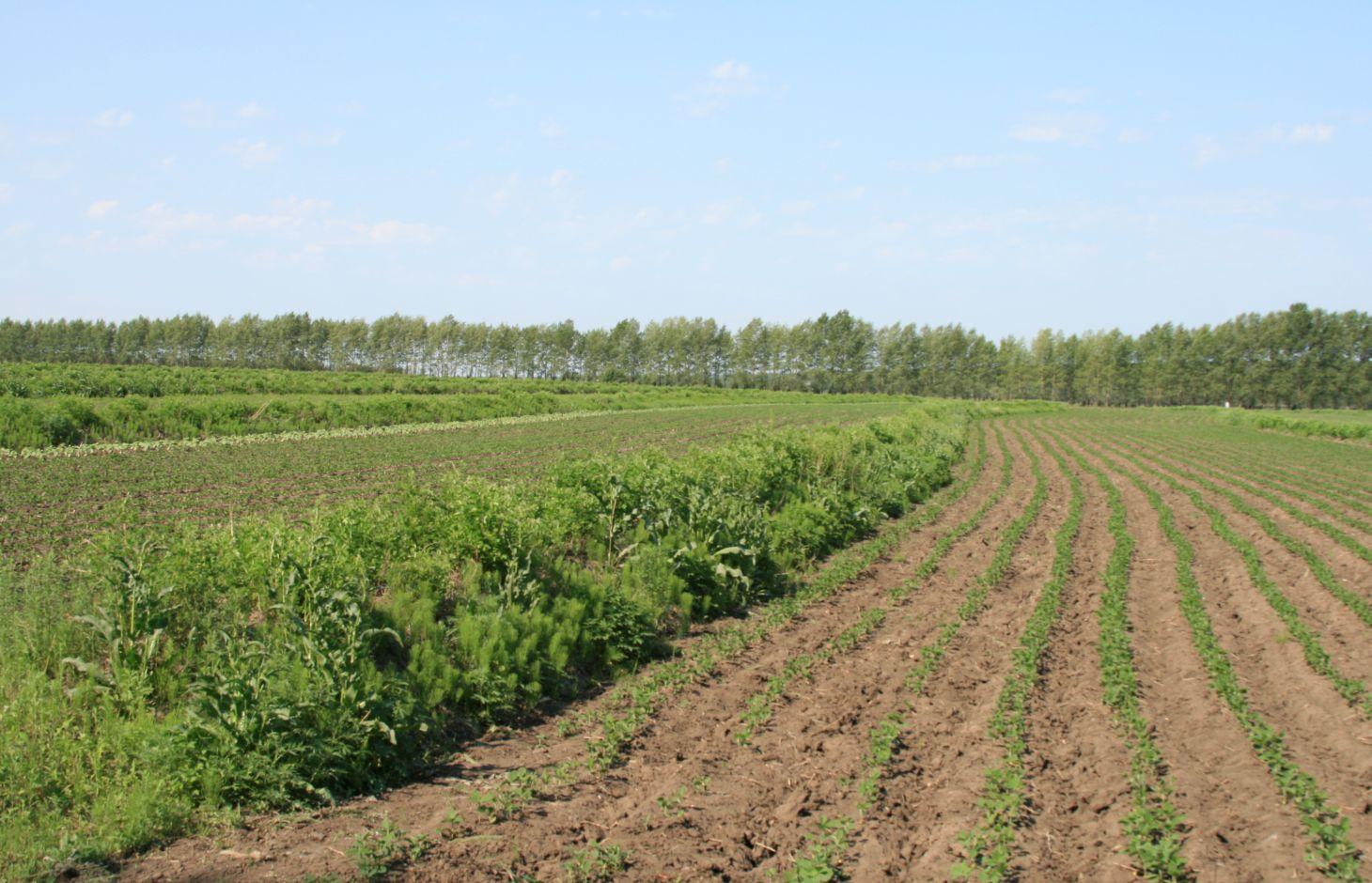
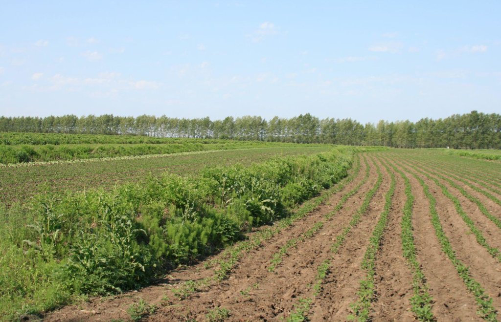
Belts of shrub or grass, planted on the level bund which constructed along contour line in gentle slope farmland in the black soil region of Northeast China.
2.2 وصف تفصيلي للتقنية
الوصف:
Shrubbery buffer strip with bund(SBSWB) is a traditional technology, it is introduced by the field staff about 60 years ago who worked in the farm in Heilongjiang province.This technology with low-cost, high effectives and easy to construct, which has been widely applied in all black soil region of Northeast China (Heilongjiang,Jilin,Liaoning,North of Inner Mongolia Autonomous Region).
Purpose of the Technology: The final purpose of these buffer strips is increasing crop production by decreasing soil loss. More specific objectives include: 1)protect the land from surface erosion by cutting slope length, increase infiltration and soil moisture; 2)to prevent soil loss of gentle slope farmland by allowing excess runoff to filter through but trapping sediment; 3) through the effect of tillage and water erosion between the strips, level bund lead to the formation of forward slope terraces over time, then developing into terrace final;4) creation of opportunities for additional income by harvesting fodder(grass) production and fruits(shrub).
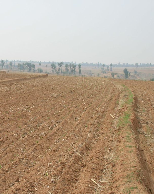
Establishment / maintenance activities and inputs: A construction is generally carried out in autumn of the year; plantation is made in spring of the next year. The construction in a man-machine integration mode is generally carried out step by step and from top to bottom along the contour line(s). The ladder-shaped cross section of a ridge is 0.3-0.5m in width (suitable width on the top), 0.5-0.6m in height, 1:1 or 1:0.5 in inner-side gradient and 1:0.5 in outer-side gradient.
In a construction, peel the surface soil with machine, with the peeling depth generally being 0.3m, which should be subject to soil layer depth; then haul the ridge construction plough (a kind of machine or device) with a tractor to build the ridges, consolidate the ridges through artificial slapping; Finally restore the surface soil to accomplish ridge construction. The tops of the constructed ridges should be maintained to be in a horizontal surface. The distance between two ridges in this region is generally stipulated to be 50 meters. The soil for ridge construction should be free from such sundries as gravels, tree roots and turfs.
Natural / human environment: Shrubbery buffer strip is found mainly in Northeast China, at altitudes between 700 and 1600 m. Climate there is cold in winters and cool in summers, with a monsoon moisture regime. In the area, the annual mean temperatures is from 2 to 8 °C, and the annual mean precipitation is from 500 to 1000 mm. Most of the farmland slopes are less than 7°but slope lengths mainly range from 200 to 1000m in this area.
Northeast China, the grain production base of China, or the bread basket of China, includes three provinces (Hei-long-jiang, Ji-lin, and Liao-ning) and the eastern part of the Inner Mongolian autonomous region. In 2009, 17.1% the China’s total grain production came from this region, which included 33.5%, 55.7% and 9.6% of corn, soybean, and rice, respectively. Approximately 118 million people live in this region. Grain produced per capita is over 1000 kg annually.
2.3 صور التقنية
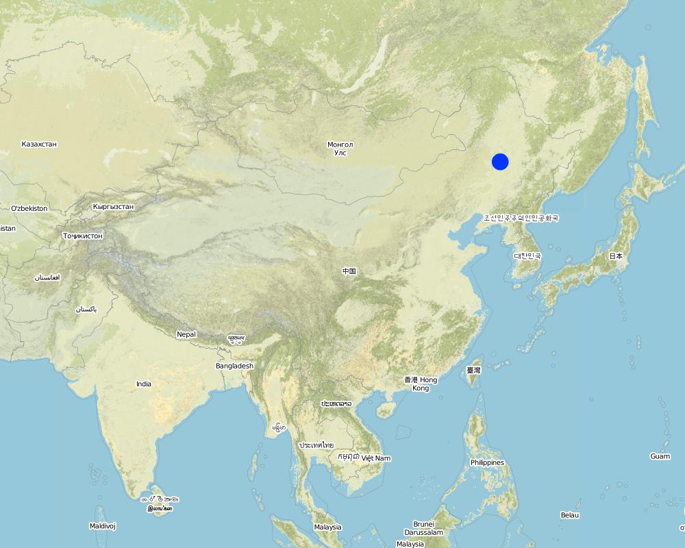
2.5 البلد/المنطقة/المواقع التي تم تنفيذ التقنية فيها والتي يغطيها هذا التقييم
البلد:
الصين
المنطقة/الولاية/المحافظة:
The black soil region of Northeast China
مزيد من التفاصيل حول الموقع:
Heilongjiang,Jilin,Liaoning,North of Inner Mongolia Autonomous Region
حدد انتشار التقنية:
- منتشرة بالتساوي على مساحة
إذا كانت المساحة الدقيقة غير معروفة، فيرجى الإشارة إلى المنطقة التقريبية المغطاة:
- > 10,000 كم2
التعليقات:
This technique has been common applied in gentle slope farmland of the black soil region of Northeast China. It is very useful for reduce soil loss and intercept runoff.
Map
×2.6 تاريخ التنفيذ
في حالة عدم معرفة السنة بالتحديد، يرجى الإشارة إلى التاريخ التقريبي:
- منذ أكثر من 50 عامًا (تقليدي)
2.7 إدخال التقنية
حدد كيف تم إدخال التقنية:
- كجزء من النظام التقليدي (> 50 عامًا)
التعليقات (نوع المشروع، الخ):
SBSWB appear in the vicinity of Heilongjiang province in the last century 60's
3. تصنيف تقنية الإدارة المستدامي للأراضي
3.2 نوع (أنواع) استخدام الأراضي الحالية حيث يتم تطبيق التقنية

الأراضي الزراعية
- زراعة سنوية
الزراعة السنوية - حدد المحاصيل:
- الحبوب - الذرة
- الحبوب البقولية والبقول -فول الصويا
- المحاصيل الجذرية/الدرنية -الشمندر السكري
- rice
عدد مواسم الزراعة في السنة:
- 1
حدد:
Longest growing period in days: 150Longest growing period from month to month: April to August
التعليقات:
Main cash crop: soybean, sugarbeet
Main food crop: paddy rice, maize
Major land use problems (compiler’s opinion): Beacuse of long slope, high rainfall intensity, freezing and thawing processes, and intensive cultivation has lead to substantial water runoff, soil erosion, and gully formation. Soil erosion has been the serious problem threatening agriculture sustainability in the region for decades.The flora of the area are very diverse.
Major land use problems (land users’ perception): Soil fertility and crop yeild are decreasing year by year.
3.4 إمدادات المياه
إمدادات المياه للأرض التي يتم تنفيذ التقنية عليها:
- بعلية
التعليقات:
Water supply also mixed rainfed - irrigated
3.5 مجموعةالإدارة المستدامة للأراضي التي تنتمي إليها هذه التقنية
- التدابير المتقاطعة للمنحدرات
3.6 التدابير التقنية في مجال إلادارة المستدامة للأراضي

التدابير النباتية
- V2: الأعشاب والنباتات العشبية المعمرة

التدابير البنيوية
- الحواجز والضفاف
التعليقات:
Main measures: vegetative measures, structural measures
Type of vegetative measures: aligned: -contour
3.7 الأنواع الرئيسية من تدهور الأراضي التي تناولتها التقنية

تآكل التربة بالمياه
- الوزن(Wt): فقدان التربة السطحية/تآكل السطح
- (Wo:) تأثيرات التدهور من مواقع أخرى

تآكل التربة الناتج عن الرياح
- (Et): فقدان التربة السطحية
التعليقات:
Main type of degradation addressed: Wt: loss of topsoil / surface erosion
Secondary types of degradation addressed: Wo: offsite degradation effects, Et: loss of topsoil
Main causes of degradation: soil management (The extensive cultivation and management modes reduce the thickness of black soil layer by 0.5 cm per year.), population pressure (Great population pressure makes the land carrying capacity decline year by year.), education, access to knowledge and support services (The channels for the local peasants with low levels of education to learn knowledge are few, and they will not take initiative to learn knowledge.)
Secondary causes of degradation: over-exploitation of vegetation for domestic use (This area is the most important grain production area in China, there is serious excessive exploitation in this area.), change of seasonal rainfall (The rainy seasons mainly focus on July and August.), Heavy / extreme rainfall (intensity/amounts) (The downpours in summer bring about soil loss.), land tenure (As the lands are owned by country or by peasant communities, the peasants are not strongly aware of the importance of land protection.), poverty / wealth (The serious gap between rich and poor)
3.8 منع أو حد أو عكس تدهور الأراضي
تحديد هدف التقنية فيما يتعلق بتدهور الأراضي:
- منع تدهور الأراضي
- الحد من تدهور الأراضي
التعليقات:
Main goals: mitigation / reduction of land degradation
Secondary goals: prevention of land degradation
4. المواصفات الفنية، وأنشطة التنفيذ، والمدخلات، والتكاليف
4.1 الرسم الفني للتقنية
المواصفات الفنية (المتعلقة بالرسم الفني):
The upper-base width, lower base width, height, slope ratio and spacing of a ridge are 0.5m, 1m, 0.5m, 1:0.5 and 40-60m respectively. A row spacing of the shrubs planted on the ridges should be 0.5m. Generally one row on each ridge is enough. About 80 shrubs are needed for every hectare; if herbaceous plants are planted, no special plantations are required.
Location: Chao Yang City. Liao Ning Province
Date: Nov 12,2012
Technical knowledge required for field staff / advisors: moderate (Field staff/agricultural advisor should have intermediate know-how level, because land user should be instructed by them)
Technical knowledge required for land users: low (The knowledge level of lander user is not required to be high, who just need(s) to follow the instructions from field staff/agricultural advisor)
Main technical functions: control of dispersed runoff: retain / trap, control of dispersed runoff: impede / retard, reduction of slope length, improvement of water quality, buffering / filtering water, sediment retention / trapping, sediment harvesting
Secondary technical functions: control of concentrated runoff: retain / trap, control of concentrated runoff: impede / retard, improvement of ground cover, improvement of topsoil structure (compaction), increase in organic matter, increase in nutrient availability (supply, recycling,…), increase of infiltration, increase / maintain water stored in soil, water harvesting / increase water supply, water spreading, increase of biomass (quantity), promotion of vegetation species and varieties (quality, eg palatable fodder), spatial arrangement and diversification of land use
Aligned: -contour
Vegetative material: F : fruit trees / shrubs
Number of plants per (ha): 200-600
Vertical interval between rows / strips / blocks (m): 5.644-8.466
Spacing between rows / strips / blocks (m): 40-60
Vertical interval within rows / strips / blocks (m): 0.5
Width within rows / strips / blocks (m): 0.5
Fruit trees / shrubs species: caragana, lespedeza, amorpha, daylily, Melilotus
Slope (which determines the spacing indicated above): 5-8%
Gradient along the rows / strips: 0%
Wall/ barrier
Vertical interval between structures (m): 2.09-5.55
Spacing between structures (m): 40-60
Height of bunds/banks/others (m): 0.3-0.5
Width of bunds/banks/others (m): 0.5-1
Length of bunds/banks/others (m): >100
Construction material (earth): The soil should be free from such sundries as gravels, tree roots and turfs.
Slope (which determines the spacing indicated above): 5-8%
Lateral gradient along the structure: 0%
المؤلف:
Zhao Mei, Beijing Normal University, Beijing, China
4.2 معلومات عامة بخصوص حساب المدخلات والتكاليف
عملة أخرى/ عملة وطنية (حدد):
RMB
إذا كان ذا صلة، وضح سعر الصرف من الدولار الأمريكي إلى العملة المحلية (على سبيل المثال، 1 دولار أمريكي = 79.9 ريال برازيلي): 1 دولار أمريكي =:
6,25
اذكر متوسط تكلفة أجر العمالة المستأجرة في اليوم الواحد:
9.25
4.3 أنشطة التأسيس
| النشاط | التوقيت (الموسم) | |
|---|---|---|
| 1. | Plant shrubbery | autumn |
| 2. | Layout of contour and the line of SBSWB with the leveling | autumn |
| 3. | Build the ridge | autumn |
4.4 التكاليف والمدخلات اللازمة للتأسيس
| تحديد المدخلات | الوحدة | الكمية | التكاليف لكل وحدة | إجمالي التكاليف لكل مدخل | % من التكاليف التي يتحملها مستخدمو الأراضي | |
|---|---|---|---|---|---|---|
| العمالة | Layout of contour | Person/day | 3,0 | 16,0 | 48,0 | |
| العمالة | Build ridge | Person/day | 36,0 | 9,6 | 345,6 | |
| معدات | Machine use | hours/day | 1,0 | 80,0 | 80,0 | |
| معدات | tools | day | 1,0 | 8,0 | 8,0 | |
| المواد النباتية | Seedling Plant shrubbery | ha | 600,0 | 0,016 | 9,6 | |
| إجمالي تكاليف إنشاء التقنية | 491,2 | |||||
| إجمالي تكاليف إنشاء التقنية بالدولار الأمريكي | 78,59 | |||||
التعليقات:
Duration of establishment phase: 1 month(s)
4.5 الصيانة/الأنشطة المتكررة
| النشاط | التوقيت/الوتيرة | |
|---|---|---|
| 1. | The farmers will actively protect the Bund in their land. Don't need money. | autumn |
| 2. | The farmers will actively protect the Bund in their land. Don't need money. | autumn |
4.6 التكاليف والمدخلات اللازمة للصيانة/للأنشطة المتكررة (سنويًا)
التعليقات:
Machinery/ tools: Spade, Spade
3 people are required to layout contour, daily labor cost for per person is 100 Yuan, so the total labor cost is 300Yuan ($48), tools fee is 50Yuan ($8).
One tractor can built 2.6 ha of ridges per day at a cost of 500 Yuan ($80). The ridges constructed should be artificially tamped, 120 people are needed to tamp the ridges in an area of 2.6ha, about 46 people for each hectare. As the daily labor cost for per person is 60 Yuan, the total expense on each hectare is 2760 Yuan($441.6), and the labor intensity is intermediate.
If shrubs are planted on the ridges, 400 shrubs are required for each 1 hectare management area. In addition, as the price of caragana microphylla in 2012 is 0.1 Yuan per one, the total cost of the caragana microphyllas per hectare should be 40Yuan($6.4).
Therefore, the total construction cost per hectare is 3650Yuan($584).
4.7 أهم العوامل المؤثرة على التكاليف
قدم وصفا لأهم العوامل التي تؤثر على التكاليف:
The most determinate fators affecting the cost is labour
5. البيئة الطبيعية والبشرية
5.1 المناخ
هطول الأمطار السنوي
- < 250 مم
- 251- 500 ملم
- 501 - 750ملم
- 1,000-751 ملم
- 1,500-1,100 ملم
- 2,000-1,500 ملم
- 3,000-2,001 ملم
- 4,000-3,100 ملم
- > 4000 ملم
المنطقة المناخية الزراعية
- شبه رطبة
- شبه قاحلة
Thermal climate class: temperate
Thermal climate class: boreal
5.2 طوبوغرافيا
متوسط الانحدارات:
- مسطح (0-2%)
- بسيط (3-5%)
- معتدل (6-10%)
- متدحرج (11-15%)
- تلال (16-30%)
- شديدة الانحدار(31-60%)
- فائقة الانحدار (>60%)
التضاريس:
- هضاب/سهول
- أثلام مرتفعة
- المنحدرات الجبلية
- منحدرات التلال
- منحدرات في السفوح
- قاع الوادي
المنطقة الارتفاعية:
- 100-0 متر فوق سطح البحر
- 500-101 متر فوق سطح البحر
- 1,000-501 متر فوق سطح البحر
- 1,500-1,001 متر فوق سطح البحر
- 2,000-1,501 متر فوق سطح البحر
- 2,500-2,100 متر فوق سطح البحر
- 3,000-2,501 متر فوق سطح البحر
- 4,000-3,001 متر فوق سطح البحر
- > 4000 متر فوق سطح البحر
5.3 التربة
متوسط عمق التربة:
- ضحل جدًا (0-20 سم)
- ضحلة (21-50 سم)
- متوسطة العمق (51-80 سم)
- عميقة (81-120 سم)
- عميقة جدًا (> 120 سم)
قوام التربة (التربة السطحية):
- متوسط ( طميي، سلتي)
المواد العضوية في التربة السطحية:
- عالية (>3%)
- متوسطة (1-3%)
إذا كان متاحًا، قم بإرفاق وصف كامل للتربة أو تحديد المعلومات المتوفرة، على سبيل المثال نوع التربة، الرقم الهيدروجيني/ درجة حموضة التربة، قدرة التبادل الكاتيوني، النيتروجين، الملوحة وما إلى ذلك.
Soil fertility: high
Soil drainage / infiltration: good
Soil water storage capacity: low - medium
5.4 توافر المياه ونوعيتها
منسوب المياه الجوفية:
50-5 م
توافر المياه السطحية:
جيد
نوعية المياه (غير المعالجة):
للاستخدام الزراعي فقط (الري)
5.5 التنوع البيولوجي
تنوع الأنواع:
- متوسط
5.6 خصائص مستخدمي الأراضي الذين يطبقون التقنية
التوجه السوقي لنظام الإنتاج:
- مختلط (كفاف/ تجاري)
الدخل من خارج المزرعة:
- >50% من إجمالي الدخل
المستوى النسبي للثروة:
- متوسط
- ثري
أفراداً أو مجموعات:
- المجموعات/ المجتمع المحلي
مستوى المكننة:
- عمل يدوي
- ميكانيكية/ مزودة بمحرك
الجنس:
- نساء
- رجال
اذكر الخصائص الأخرى ذات الصلة لمستخدمي الأراضي:
Land users applying the Technology are mainly common / average land users
Population density: 50-100 persons/km2
Annual population growth: < 0.5%
5% of the land users are very rich.
45% of the land users are rich.
35% of the land users are average wealthy.
15% of the land users are poor.
5% of the land users are poor.
5.7 متوسط مساحة الأرض التي يستخدمها مستخدمو الأراضي الذين يطبقون التقنية
- < 0.5 هكتارا
- 0.5 - 1 هكتار
- 1 -2 هكتار
- 2 - 5 هكتار
- 5 - 15 هكتار
- 15 - 50 هكتار
- 50 - 100هكتار
- 500-100 هكتار
- 1,000-500 هكتار
- 10,000-1,000 هكتار
- > 10,000 هكتار
هل يعتبر هذا نطاقًا صغيرًا أو متوسطًا أو واسعا (في إشارة إلى السياق المحلي)؟:
- على نطاق متوسط
5.8 ملكية الأراضي، وحقوق استخدام الأراضي، وحقوق استخدام المياه
ملكية الارض:
- مجتمعي/قروي
حقوق استخدام الأراضي:
- فردي
حقوق استخدام المياه:
- مجتمعي (منظم)
5.9 الوصول إلى الخدمات والبنية التحتية
الصحة:
- ضعيف
- معتدل
- جيد
التعليم:
- ضعيف
- معتدل
- جيد
المساعدة التقنية:
- ضعيف
- معتدل
- جيد
العمل (على سبيل المثال خارج المزرعة):
- ضعيف
- معتدل
- جيد
الأسواق:
- ضعيف
- معتدل
- جيد
الطاقة:
- ضعيف
- معتدل
- جيد
الطرق والنقل:
- ضعيف
- معتدل
- جيد
مياه الشرب وخدمات الصرف الصحي:
- ضعيف
- معتدل
- جيد
الخدمات المالية:
- ضعيف
- معتدل
- جيد
6. الآثار والتصريحات الختامية
6.1 الآثار التي أظهرتها التقنية في الموقع
الآثار الاجتماعية والاقتصادية
الإنتاج
إنتاج المحاصيل
إنتاج الأعلاف
جودة العلف
إنتاج حيواني
إنتاج الخشب
تنوع المنتج
منطقة الإنتاج
إدارة الأراضي
توليد الطاقة
توافر المياه ونوعيتها
توافر مياه الشرب
توافر المياه للماشية
نوعية المياه للماشية
توافر مياه الري
نوعية مياه الري
الطلب على مياه الري
الدخل والتكاليف
النفقات على المدخلات الزراعية
دخل المزرعة
تنوع مصادر الدخل
فروقات اقتصادية
عبء العمل
الآثار الاجتماعية والثقافية
الفرص الثقافية
الفرص الترفيهية
المؤسسات المجتمعية
المؤسسات الوطنية
التخفيف من حدة الصراع
Livelihoods and human well-being
الآثار الايكولوجية
دورة المياه / الجريان السطحي
كمية المياه
جودة المياه
حصاد / جمع المياه
الجريان السطحي
تصريف المياه الزائدة
مستوى المياه الجوفية/ الطبقة المائية الجوفية
التبخر
التربة
رطوبة التربة
غطاء التربة
فقدان التربة
تكون قشرة التربة السطحية/انسداد مسام التربة
تراص التربة
دورة المغذيات/إعادة الشحن
الملوحة
المادة العضوية في التربة/تحت الطبقة c
التنوع البيولوجي: الغطاء النباتي، الحيوانات
الكتلة الحيوية/ طبقة الكربون فوق التربة
التنوع النباتي
التنوع الحيواني
الأنواع المفيدة
الحد من مخاطر المناخ والكوارث
انبعاث الكربون والغازات المسببة للاحتباس الحراري
سرعة الرياح
6.2 الآثار التي أظهرتها التقنية خارج الموقع
توافر المياه
تدفقات مائية موثوقة ومستقرة في موسم الجفاف
الفيضان في اتجاه مجرى النهر
تراكم الطمي باتجاه مصب النهر
تلوث المياه الجوفية/الأنهار
القدرة على التخفيف / الترشيح
الرواسب المنقولة بواسطة الرياح
الأضرار التي لحقت بحقول الجيران
الضرر على البنية التحتية العامة/ الخاصة
6.3 تعرض التقنية وحساسيتها لتغير المناخ التدريجي والظواهر المتطرفة/الكوارث المرتبطة بالمناخ (كما يراها مستخدمو الأراضي)
تغير مناخ تدريجي
تغير مناخ تدريجي
| الموسم | زيادة أو نقصان | كيف تتعامل التقنية مع ذلك؟ | |
|---|---|---|---|
| درجة الحرارة السنوية | زيادة | جيدا |
الظواهر المتطرفة / الكوارث المرتبطة بالمناخ
الكوارث الجوية
| كيف تتعامل التقنية مع ذلك؟ | |
|---|---|
| عاصفة ممطرة محلية | جيدا |
| عاصفة هوائية محلية | جيدا |
الكوارث المناخية
| كيف تتعامل التقنية مع ذلك؟ | |
|---|---|
| جفاف | جيدا |
الكوارث الهيدرولوجية
| كيف تتعامل التقنية مع ذلك؟ | |
|---|---|
| فيضان عام (نهر) | جيدا |
العواقب الأخرى المتعلقة بالمناخ
العواقب الأخرى المتعلقة بالمناخ
| كيف تتعامل التقنية مع ذلك؟ | |
|---|---|
| انخفاض فترة النمو | جيدا |
6.4 تحليل التكلفة والعائد
كيف يمكن مقارنة العوائد نسبة لتكاليف الإنشاء (من وجهة نظر مستخدمي الأراضي)؟
عوائد قصيرة الأجل:
سلبي قليلا
عوائد طويلة الأجل:
إيجابي
كيف تتم مقارنة العوائدمع كلفة الصيانة/التكاليف المتكررة (من وجهة نظر مستخدمي الأراضي)؟
عوائد قصيرة الأجل:
محايد/متوازن
عوائد طويلة الأجل:
ايجابي جدا
التعليقات:
Although Certain quantity of land will be occupied and grain output will be affected in SBSWS during the early period of a construction, in the long run, SBSWS can prevent the loss of the most fertile surface soil, in addition, with the ever increased quantity of the sediment intercepted by SBSWS and as the heights of the vegetational belts increase year by year, the slope croplands will become bench terraces, and the grain output will be increased.
6.5 اعتماد التقنية
إذا كان متاحًا، قم بتحديد الكمية (عدد الأسر المعيشية و/أو المساحةالمغطاة):
NA
التعليقات:
80% of land user families have adopted the Technology with external material support
Comments on acceptance with external material support: Large-area popularization of SBSWB has been achieved in the locality.
20% of land user families have adopted the Technology without any external material support
Comments on spontaneous adoption: The implementation of this measure was accomplished under the encouragement and support of the government. There are relatively few peasant households who initially take this measure. The main reason for the peasant reluctance to adopt this measure is that the ridges will occupy land and reduce arable area. They are unconscious of and do not care about soil loss, and unable to realize in the long run the harm brought about by soil loss.
There is a little trend towards spontaneous adoption of the Technology
Comments on adoption trend: The trend depands on government support
6.7 نقاط القوة / المزايا / الفرص التي توفرها التقنية
| نقاط القوة/ المزايا/ الفرص من وجهة نظر مستخدمي الأراضي |
|---|
|
Convenient for construction How can they be sustained / enhanced? Popularization carried on |
| نقاط القوة/ المزايا/ الفرص من وجهة نظر جامع المعلومات أو غيره من الاشخاص الرئيسيين لمصدر المعلومات |
|---|
|
Gradual formation of the slope-type terraces, which can be developed into bench terraces many years later How can they be sustained / enhanced? Increase of ridge height year by year |
|
Intercepting the sediments carried by runoffs, preventing water and soil loss of the arable lands on the gentle slopes How can they be sustained / enhanced? In combination with other water and soil conservation measures during operation, such as no-tillage and drainage ditches; |
|
increase of infiltration How can they be sustained / enhanced? Chopping down branches at regular intervals to guarantee that the plants on the ridges will not enter into rivary with the crops over water and sunlight; |
6.8 نقاط ضعف / مساوىء / مخاطر التقنية وسبل التغلب عليها
| نقاط الضعف/ المساوىء/ المخاطر من وجهة نظر مستخدم الأراضي | كيف يمكن التغلب عليها؟ |
|---|---|
| The ridges occupy land and reduce arable area | government support |
| نقاط الضعف/ المساوىء/ المخاطر من وجهة نظر جامع المعلومات أو غيره من الاشخاص الرئيسيين لمصدر المعلومات | كيف يمكن التغلب عليها؟ |
|---|---|
| Reduction of arable lands brings about low enthusiasm of the peasants | Conflict between the arable lands and the immediate interests of the peasants. Popularization of water and soil preservation knowledge should be strangthened to make the presants realize that although the immediate interests will be hurt, the long-term interests will increase. |
7. المراجع والروابط
7.1 طرق جمع/مصادر المعلومات
7.2 المراجع للمنشورات المتاحة
العنوان، المؤلف، السنة، النظام القياسي الدولي لترقيم الكتب ISBN:
Title:Techniques standard for comprehensive control of soil erosion in the black soil region Author:Shen bo; Meng lingqinYears:2009
متاح من أين؟كم التكلفة؟:
internal materials
الروابط والوحدات المواضيعية
توسيع الكل طي الكلالروابط
لا يوجد روابط
الوحدات المواضيعية
لا يوجد وحدات مواضيعية


