Riverbank Protection [النيبال]
- تاريخ الإنشاء:
- تحديث:
- جامع المعلومات: Shreedip Sigdel
- المحرر: –
- المراجعون: David Streiff, Alexandra Gavilano
Nadi Kinara Samrakchen (Main Contributor: Uddhaw Ghimire, DSCO)
technologies_1692 - النيبال
عرض الأقسام
توسيع الكل طي الكل1. معلومات عامة
1.2 تفاصيل الاتصال بالأشخاص الرئيسيين لمصدر المعلومات والمؤسسات المشاركة في تقييم وتوثيق التقنية
متخصص في الإدارة المستدامة للأراضي:
Ghimire Uddhaw
District Soil Conservation Office
النيبال
Office:
Programme Coordination Office
Helvetas Swiss Intercooperation Nepal
النيبال
اسم المؤسسة (المؤسسات) التي سهلت توثيق/تقييم التقنية (إذا كان ذلك على صلة)
District Soil Conservation Office (DSCO) - النيبالاسم المؤسسة (المؤسسات) التي سهلت توثيق/تقييم التقنية (إذا كان ذلك على صلة)
HELVETAS (Swiss Intercooperation)اسم المؤسسة (المؤسسات) التي سهلت توثيق/تقييم التقنية (إذا كان ذلك على صلة)
Department of Soil Conservation and Watershed Mana (Department of Soil Conservation and Watershed Mana) - النيبالاسم المؤسسة (المؤسسات) التي سهلت توثيق/تقييم التقنية (إذا كان ذلك على صلة)
ICIMOD International Centre for Integrated Mountain Development (ICIMOD) - النيبال1.3 الشروط المتعلقة باستخدام البيانات الموثقة من خلال WOCAT
يوافق جامع المعلومات والشخص (لاشخاص) الرئيسي لمصدر المعلومات على الشروط المتعلقة باستخدام البيانات الموثقة من خلال WOCAT:
نعم
2. وصف تقنيةالإدارة المستدامي للأراضي
2.1 وصف مختصر للتقنية
تعريف التقنية:
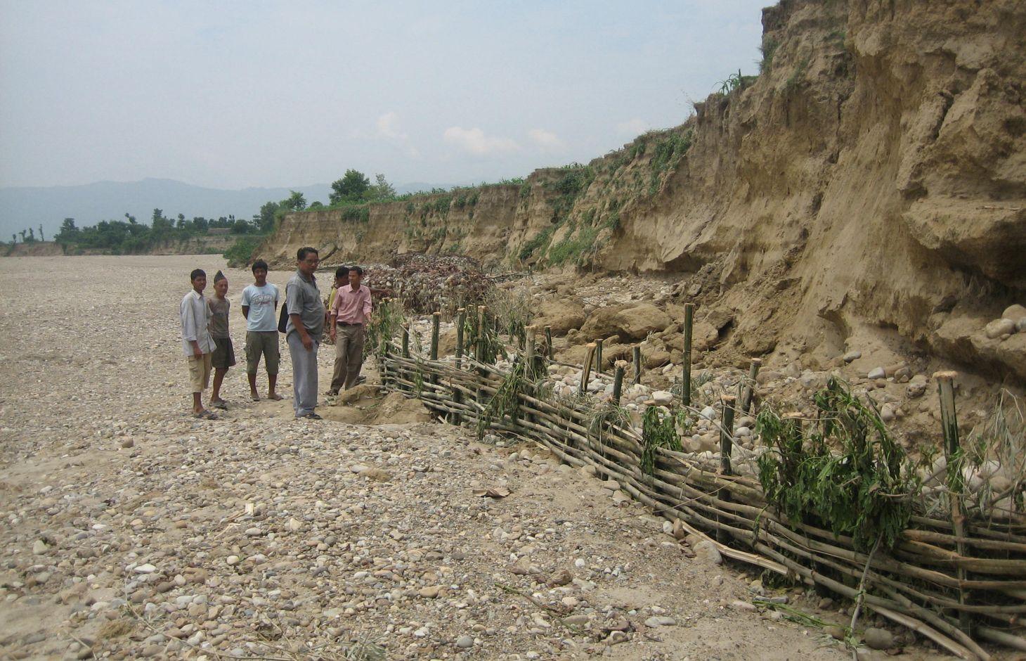
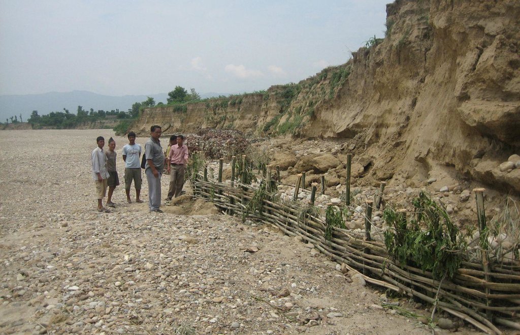
Local materials and knowledge can be used to construct low-cost structural measures that help to prevent the erosion of riverbanks and the loss of agricultural and residential land.
2.2 وصف تفصيلي للتقنية
الوصف:
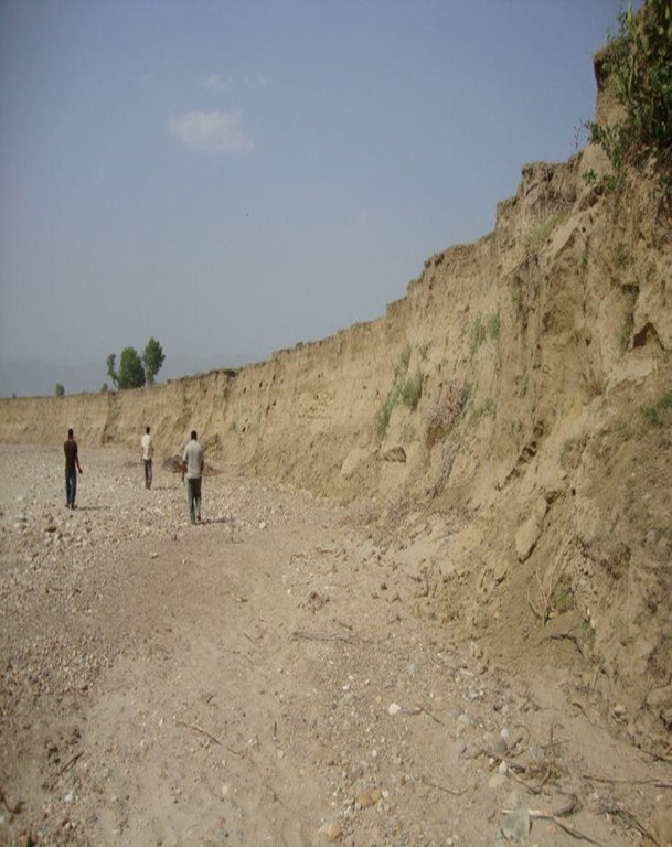
Riverbank cutting occurs naturally along the rivers that run along the foothills of the Chure (Siwalik) range in Nepal when the stream collides with the river bank or the bank is eroded by water coming from agricultural land above the affected area. When riverbank cutting occurs, it leaves behind an eroded area shaped like a small cliff. This erosion takes place naturally and is difficult to stop because the site is devoid of natural vegetation. It is important to undertake conservation measures because when the riverbank is eroded it damages agricultural land and decreases soil fertility. When the productivity of the land is decreased it affects the lives and livelihoods of nearby communities most of whom are subsistence farmers.
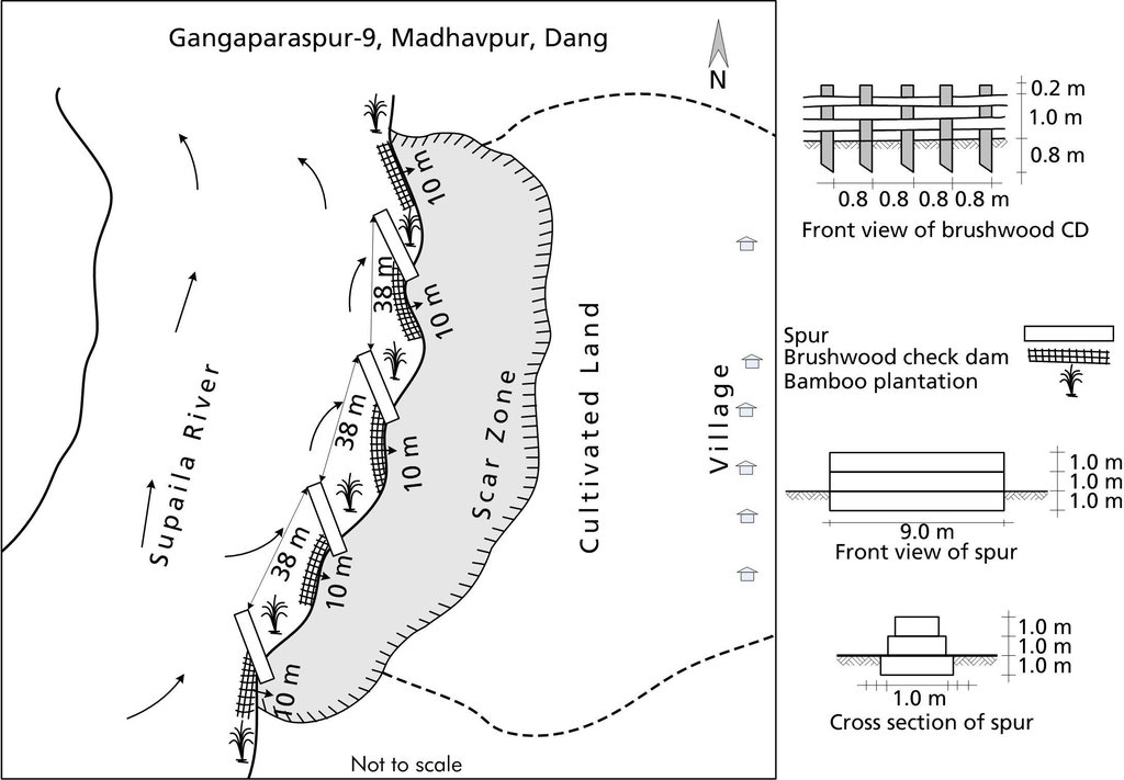
Purpose of the Technology: Communities have developed local measures to help protect the riverbanks and to prevent further erosion and cutting. This technology uses both structural and vegetative measures to help control the erosion and protect both agricultural land and settlement areas from flooding. Check dams are placed at intervals to divert water, additional support is provided by spurs. Bamboo rhizomes are planted between them and Napier grass (Pennisetum purpureum) is planted at the back of the structures so that as the plants grow their roots help to anchor the structure. The washed out areas can be used to generate some income by planting them with greenery and fruit trees. The site needs to be monitored annually and where necessary the structures either need to be repaired or supplemented by building additional structures.
Establishment / maintenance activities and inputs: This technology is a blend of local skills and expertise with some external technical input. The key features of the technology are as follow:
• It uses locally available construction materials, tools, equipment, and vegetation.
• It is easy to replicate.
• It is affordable for local people.
• It is environmentally friendly.
A demonstration plot was established by the District Soil Conservation Office (DSCO) in Dang, but the technology needs to be replicated in other areas with action research and experience
2.3 صور التقنية
2.5 البلد/المنطقة/المواقع التي تم تنفيذ التقنية فيها والتي يغطيها هذا التقييم
البلد:
النيبال
مزيد من التفاصيل حول الموقع:
Gobardiha-9, Madhabpur, Dang District,
حدد انتشار التقنية:
- يتم تطبيقها في نقاط محددة/ تتركز على مساحة صغيرة
2.7 إدخال التقنية
حدد كيف تم إدخال التقنية:
- من خلال المشاريع/ التدخلات الخارجية
3. تصنيف تقنية الإدارة المستدامي للأراضي
3.1 الغرض الرئيسي ( الأغراض الرئيسية) للتقنية
- الحد من تدهور الأراضي ومنعه وعكسه
- حماية مستجمعات المياه / المناطق الواقعة في اتجاه مجرى النهر - مع تقنيات أخرى
- الحد من مخاطر الكوارث
3.2 نوع (أنواع) استخدام الأراضي الحالية حيث يتم تطبيق التقنية

الأراضي الزراعية
- زراعة سنوية
عدد مواسم الزراعة في السنة:
- 2

الغابات/ الأراضي الحرجية
منتجات وخدمات:
- حطب الوقود
- الرعي/ رعي أطراف الأشجار الفتية (الجلح)
التعليقات:
Major land use problems (compiler’s opinion): The land is degraded by riverbed cutting and nearby villages are threatened by flooding. The amount of land available for agriculture decreases annually giving rise to a food security problem. Entire villages may have to move to avoid being flooded.
Forest products and services: fuelwood, grazing / browsing
Livestock is grazing on crop residues
3.5 مجموعةالإدارة المستدامة للأراضي التي تنتمي إليها هذه التقنية
- إدارة المياه السطحية (الينابيع، الأنهار، البحيرات، البحار)
3.6 التدابير التقنية في مجال إلادارة المستدامة للأراضي

التدابير النباتية
- V2: الأعشاب والنباتات العشبية المعمرة

التدابير البنيوية
- S5: السدود، الأحواض الصغيرة، البرك
3.7 الأنواع الرئيسية من تدهور الأراضي التي تناولتها التقنية

تآكل التربة بالمياه
- (Wr):انجراف ضفة النهر
التعليقات:
Main causes of degradation: floods
3.8 منع أو حد أو عكس تدهور الأراضي
تحديد هدف التقنية فيما يتعلق بتدهور الأراضي:
- منع تدهور الأراضي
- الحد من تدهور الأراضي
4. المواصفات الفنية، وأنشطة التنفيذ، والمدخلات، والتكاليف
4.1 الرسم الفني للتقنية
المواصفات الفنية (المتعلقة بالرسم الفني):
A low cost riverbank protection scheme that can be implemented using mostly local materials.
Technical knowledge required for field staff / advisors: low
Technical knowledge required for land users: moderate
Main technical functions: control of dispersed runoff: impede / retard, control of concentrated runoff: impede / retard
Secondary technical functions: improvement of ground cover, stabilisation of soil (eg by tree roots against land slides)
المؤلف:
Bhojdeo Mandal, AK Thaku
4.2 معلومات عامة بخصوص حساب المدخلات والتكاليف
حدد كيفية احتساب التكاليف والمدخلات:
- حسب مساحة تنفيذ التقنية
الإشارة إلى حجم ووحدة المساحة:
ha
حدد العملة المستخدمة لحساب التكاليف:
- دولار أمريكي USD
4.3 أنشطة التأسيس
| النشاط | التوقيت (الموسم) | |
|---|---|---|
| 1. | Structural: Check dam construction | |
| 2. | Spur construction | |
| 3. | Vegetative: Pitting | |
| 4. | Bamboo planting | |
| 5. | Napier grass planting |
4.4 التكاليف والمدخلات اللازمة للتأسيس
| تحديد المدخلات | الوحدة | الكمية | التكاليف لكل وحدة | إجمالي التكاليف لكل مدخل | % من التكاليف التي يتحملها مستخدمو الأراضي | |
|---|---|---|---|---|---|---|
| العمالة | Construction of rivervbank protection | ha | 1,0 | 892,0 | 892,0 | 51,0 |
| معدات | Tools | ha | 1,0 | 21,0 | 21,0 | 51,0 |
| المواد النباتية | Napier grass, bamboo seedlings | ha | 1,0 | 14,0 | 14,0 | |
| مواد البناء | Stone | ha | 1,0 | 1281,0 | 1281,0 | 51,0 |
| مواد البناء | Bamboo poles | ha | 1,0 | 274,0 | 274,0 | 51,0 |
| مواد البناء | Wire for gabion box | ha | 1,0 | 1644,0 | 1644,0 | 51,0 |
| إجمالي تكاليف إنشاء التقنية | 4126,0 | |||||
| إجمالي تكاليف إنشاء التقنية بالدولار الأمريكي | 4126,0 | |||||
إذا تحمل مستخدم الأرض أقل من 100% من التكاليف، حدد من قام بتغطية التكاليف المتبقية:
The gabion boxes, the transportation costs, and some skilled labour by DSCO, Dang; whereas, the costs for the tools, local materials, and all of the unskilled labour were borne by the local community
4.5 الصيانة/الأنشطة المتكررة
| النشاط | التوقيت/الوتيرة | |
|---|---|---|
| 1. | Structural: Verify the integrity of the spurs and check dams; fortify or repair as needed. | |
| 2. | Vegetative: Maintenance costs cover only replacement and maintenance to be done by the local community for a few years until the vegetative structures are well established at the site. | |
| 3. | VegetativeCheck to see that the Napier grass seedlings have taken root; add additional plants as needed. |
4.6 التكاليف والمدخلات اللازمة للصيانة/للأنشطة المتكررة (سنويًا)
| تحديد المدخلات | الوحدة | الكمية | التكاليف لكل وحدة | إجمالي التكاليف لكل مدخل | % من التكاليف التي يتحملها مستخدمو الأراضي | |
|---|---|---|---|---|---|---|
| العمالة | Fortify and reapir check dams | ha | 1,0 | 52,0 | 52,0 | 100,0 |
| المواد النباتية | Napier grass, bamboo seedlings | ha | 1,0 | 7,0 | 7,0 | 100,0 |
| مواد البناء | Bamboo poles for replacing | ha | 1,0 | 123,0 | 123,0 | 100,0 |
| إجمالي تكاليف صيانة التقنية | 182,0 | |||||
| إجمالي تكاليف صيانة التقنية بالدولار الأمريكي | 182,0 | |||||
4.7 أهم العوامل المؤثرة على التكاليف
قدم وصفا لأهم العوامل التي تؤثر على التكاليف:
The costs for the gabion boxes, the transportation costs, and some skilled labour, were borne by the DSCO, Dang; whereas, the costs for the tools, local materials, and all of the unskilled labour were borne by the local community.
All costs and amounts are rough estimates by the technicians and authors.
5. البيئة الطبيعية والبشرية
5.1 المناخ
هطول الأمطار السنوي
- < 250 مم
- 251- 500 ملم
- 501 - 750ملم
- 1,000-751 ملم
- 1,500-1,100 ملم
- 2,000-1,500 ملم
- 3,000-2,001 ملم
- 4,000-3,100 ملم
- > 4000 ملم
المنطقة المناخية الزراعية
- شبه رطبة
Thermal climate class: tropics
5.2 طوبوغرافيا
متوسط الانحدارات:
- مسطح (0-2%)
- بسيط (3-5%)
- معتدل (6-10%)
- متدحرج (11-15%)
- تلال (16-30%)
- شديدة الانحدار(31-60%)
- فائقة الانحدار (>60%)
التضاريس:
- هضاب/سهول
- أثلام مرتفعة
- المنحدرات الجبلية
- منحدرات التلال
- منحدرات في السفوح
- قاع الوادي
المنطقة الارتفاعية:
- 100-0 متر فوق سطح البحر
- 500-101 متر فوق سطح البحر
- 1,000-501 متر فوق سطح البحر
- 1,500-1,001 متر فوق سطح البحر
- 2,000-1,501 متر فوق سطح البحر
- 2,500-2,100 متر فوق سطح البحر
- 3,000-2,501 متر فوق سطح البحر
- 4,000-3,001 متر فوق سطح البحر
- > 4000 متر فوق سطح البحر
5.3 التربة
متوسط عمق التربة:
- ضحل جدًا (0-20 سم)
- ضحلة (21-50 سم)
- متوسطة العمق (51-80 سم)
- عميقة (81-120 سم)
- عميقة جدًا (> 120 سم)
قوام التربة (التربة السطحية):
- خشن / خفيف (رملي)
المواد العضوية في التربة السطحية:
- منخفضة (<1%)
إذا كان متاحًا، قم بإرفاق وصف كامل للتربة أو تحديد المعلومات المتوفرة، على سبيل المثال نوع التربة، الرقم الهيدروجيني/ درجة حموضة التربة، قدرة التبادل الكاتيوني، النيتروجين، الملوحة وما إلى ذلك.
Soil fertility is very low
Soil drainage / infiltration is good
Soil water storage capacity is very low
5.4 توافر المياه ونوعيتها
منسوب المياه الجوفية:
50-5 م
توافر المياه السطحية:
ضعيف/ غير متوافر
نوعية المياه (غير المعالجة):
للاستخدام الزراعي فقط (الري)
5.5 التنوع البيولوجي
تنوع الأنواع:
- منخفض
5.6 خصائص مستخدمي الأراضي الذين يطبقون التقنية
التوجه السوقي لنظام الإنتاج:
- الكفاف (الإمداد الذاتي)
الدخل من خارج المزرعة:
- >50% من إجمالي الدخل
المستوى النسبي للثروة:
- ضعيف
أفراداً أو مجموعات:
- المجموعات/ المجتمع المحلي
مستوى المكننة:
- عمل يدوي
- الجر الحيواني
اذكر الخصائص الأخرى ذات الصلة لمستخدمي الأراضي:
Population density: 100-200 persons/km2
Annual population growth: 2% - 3%
5.7 متوسط مساحة الأرض التي يستخدمها مستخدمو الأراضي الذين يطبقون التقنية
- < 0.5 هكتارا
- 0.5 - 1 هكتار
- 1 -2 هكتار
- 2 - 5 هكتار
- 5 - 15 هكتار
- 15 - 50 هكتار
- 50 - 100هكتار
- 500-100 هكتار
- 1,000-500 هكتار
- 10,000-1,000 هكتار
- > 10,000 هكتار
5.8 ملكية الأراضي، وحقوق استخدام الأراضي، وحقوق استخدام المياه
ملكية الارض:
- فردية، يوجد سند ملكية
حقوق استخدام الأراضي:
- فردي
حقوق استخدام المياه:
- مجتمعي (منظم)
6. الآثار والتصريحات الختامية
6.1 الآثار التي أظهرتها التقنية في الموقع
الآثار الاجتماعية والاقتصادية
الإنتاج
خطر فشل الإنتاج
الدخل والتكاليف
دخل المزرعة
تنوع مصادر الدخل
عبء العمل
الآثار الاجتماعية والثقافية
الأمن الغذائي / الاكتفاء الذاتي
المؤسسات المجتمعية
وضع الفئات المحرومة اجتماعيا واقتصاديا
livelihood and human well-being
التعليقات/ حدد:
Agricultural land is conserved and production is increased
الآثار الايكولوجية
التربة
فقدان التربة
الحد من مخاطر المناخ والكوارث
آثار الفيضانات
آثار الجفاف
آثار السيكلون والعواصف المطرية
6.2 الآثار التي أظهرتها التقنية خارج الموقع
الفيضان في اتجاه مجرى النهر
risk of flodd for public and private infrastructure, even at some distance from the site
6.3 تعرض التقنية وحساسيتها لتغير المناخ التدريجي والظواهر المتطرفة/الكوارث المرتبطة بالمناخ (كما يراها مستخدمو الأراضي)
تغير مناخ تدريجي
تغير مناخ تدريجي
| الموسم | زيادة أو نقصان | كيف تتعامل التقنية مع ذلك؟ | |
|---|---|---|---|
| درجة الحرارة السنوية | زيادة | جيدا |
الظواهر المتطرفة / الكوارث المرتبطة بالمناخ
الكوارث الهيدرولوجية
| كيف تتعامل التقنية مع ذلك؟ | |
|---|---|
| فيضان عام (نهر) | ليس جيدا |
التعليقات:
Previously, the problem was tackled using traditional techniques alone but the results were not wholly satisfactory. After modifying (as discussed below) the structures are more robust and can withstand greater floods.
6.4 تحليل التكلفة والعائد
كيف يمكن مقارنة العوائد نسبة لتكاليف الإنشاء (من وجهة نظر مستخدمي الأراضي)؟
عوائد قصيرة الأجل:
ايجابي جدا
عوائد طويلة الأجل:
ايجابي جدا
كيف تتم مقارنة العوائدمع كلفة الصيانة/التكاليف المتكررة (من وجهة نظر مستخدمي الأراضي)؟
عوائد قصيرة الأجل:
إيجابي
عوائد طويلة الأجل:
إيجابي
6.5 اعتماد التقنية
- > 50%
إذا كان متاحًا، قم بتحديد الكمية (عدد الأسر المعيشية و/أو المساحةالمغطاة):
47 households in an area of 10 ha
من بين جميع الذين تبنوا التقنية، كم عدد الذين فعلوا ذلك بشكل تلقائي، أي دون تلقي أي حوافز مادية/مدفوعات؟:
- 10-0%
التعليقات:
There is a little trend towards spontaneous adoption of the Technology
Comments on adoption trend: A community of 47 households has agreed to use this technology to help prevent soil erosion caused by flooding. The community had started to implement local measures to minimize riverbank cutting but the efforts were not successful. The systematic introduction of well-planned gabion spurs and bamboo check dams constructed using only locally available materials, has been successful. The community is convinced that this technology is beneficial and they will continue to propagate it themselves as needed.
6.7 نقاط القوة / المزايا / الفرص التي توفرها التقنية
| نقاط القوة/ المزايا/ الفرص من وجهة نظر جامع المعلومات أو غيره من الاشخاص الرئيسيين لمصدر المعلومات |
|---|
|
The technology is low cost and can be implemented by the local community with the assistance of some technical support from the DSCO, Dang. How can they be sustained / enhanced? The DSCO, Dang, needs to continue to support the community in its efforts by technical backstopping, regular follow-up, and continued scaling up of the technology. |
|
The technology predominantly uses locally available materials. How can they be sustained / enhanced? Replication of this technology should be encouraged by the community as well as by the DSCO, Dang |
|
In the long run, vegetative structures help to propagate greenery and in so doing, they promote climate change adaptation and mitigation. How can they be sustained / enhanced? Communities should be made aware of the hazards of climate change and of what mitigation measures can be employed. |
|
Traditional measures used to help protect against flooding were very labour intensive and difficult to implement. This new method is low cost, easy to adopt, and sustainable. How can they be sustained / enhanced? Additional training with local communities can help to spread the expertise |
6.8 نقاط ضعف / مساوىء / مخاطر التقنية وسبل التغلب عليها
| نقاط الضعف/ المساوىء/ المخاطر من وجهة نظر جامع المعلومات أو غيره من الاشخاص الرئيسيين لمصدر المعلومات | كيف يمكن التغلب عليها؟ |
|---|---|
| Vegetative structures may not always take root as intended; the initial cost for the gabion cages can be high. | Try to implement the technology using vegetative measures |
| Despite the fact that the technology is known to be effective, it is not being widely implemented. | Communities need greater awareness; intensive extension is needed in order for the technology to have widespread acceptance. |
7. المراجع والروابط
7.1 طرق جمع/مصادر المعلومات
7.2 المراجع للمنشورات المتاحة
العنوان، المؤلف، السنة، النظام القياسي الدولي لترقيم الكتب ISBN:
District Forest Office, Dang; Soil Conservation and Watershed Management Measures and Low Cost Techniques; Environment Statistics of Nepal, Annual Report (2065/66)
متاح من أين؟كم التكلفة؟:
Available at DSCO, Dang and DCSWM, Kathmandu
الروابط والوحدات المواضيعية
توسيع الكل طي الكلالروابط
لا يوجد روابط
الوحدات المواضيعية
لا يوجد وحدات مواضيعية


