Double Basin Masonry Check Dam [أثيوبيا]
- تاريخ الإنشاء:
- تحديث:
- جامع المعلومات: GERBA LETA
- المحررون: Torben Helbig, Noel Templer
- المراجعون: William Critchley, Rima Mekdaschi Studer
NA
technologies_6716 - أثيوبيا
عرض الأقسام
توسيع الكل طي الكل1. معلومات عامة
1.2 تفاصيل الاتصال بالأشخاص الرئيسيين لمصدر المعلومات والمؤسسات المشاركة في تقييم وتوثيق التقنية
الشخص (الأشخاص) الرئيسي لمصدر المعلومات
متخصص في الإدارة المستدامة للأراضي:
Abdi Amir
Dry valley Rehabilitation and Productive Use (DVRPU) project of the GIZ
أثيوبيا
اسم المشروع الذي سهّل توثيق/تقييم التقنية (إذا كان ذلك على صلة)
Soil protection and rehabilitation for food security (ProSo(i)l)اسم المؤسسة (المؤسسات) التي سهلت توثيق/تقييم التقنية (إذا كان ذلك على صلة)
Alliance Bioversity and International Center for Tropical Agriculture (Alliance Bioversity-CIAT) - كينيا1.3 الشروط المتعلقة باستخدام البيانات الموثقة من خلال WOCAT
يوافق جامع المعلومات والشخص (لاشخاص) الرئيسي لمصدر المعلومات على الشروط المتعلقة باستخدام البيانات الموثقة من خلال WOCAT:
نعم
1.4 إعلان بشأن استدامة التقنية الموصوفة
هل التقنية الموصوفة هنا تمثل مشكلة فيما يتعلق بتدهور الأراضي، بحيث لا يمكن إعلانها تقنية مستدامة لإدارة الأراضي؟:
كلا
التعليقات:
The Check Dam helps to arrest the runoff of flood and rehabilitate the gully development.
1.5 الإشارة إلى الاستبيان (الاستبيانات) حول مناهج الإدارة المستدامة للأراضي (موثقة باستخدام WOCAT)
2. وصف تقنيةالإدارة المستدامي للأراضي
2.1 وصف مختصر للتقنية
تعريف التقنية:
A double basin masonry check dam is a physical structure that helps to stop gully formation or further development of gullies in dry valleys. It rehabilitates small to a medium-sized deep gullies that are eating into the heart of adjacent land.
2.2 وصف تفصيلي للتقنية
الوصف:
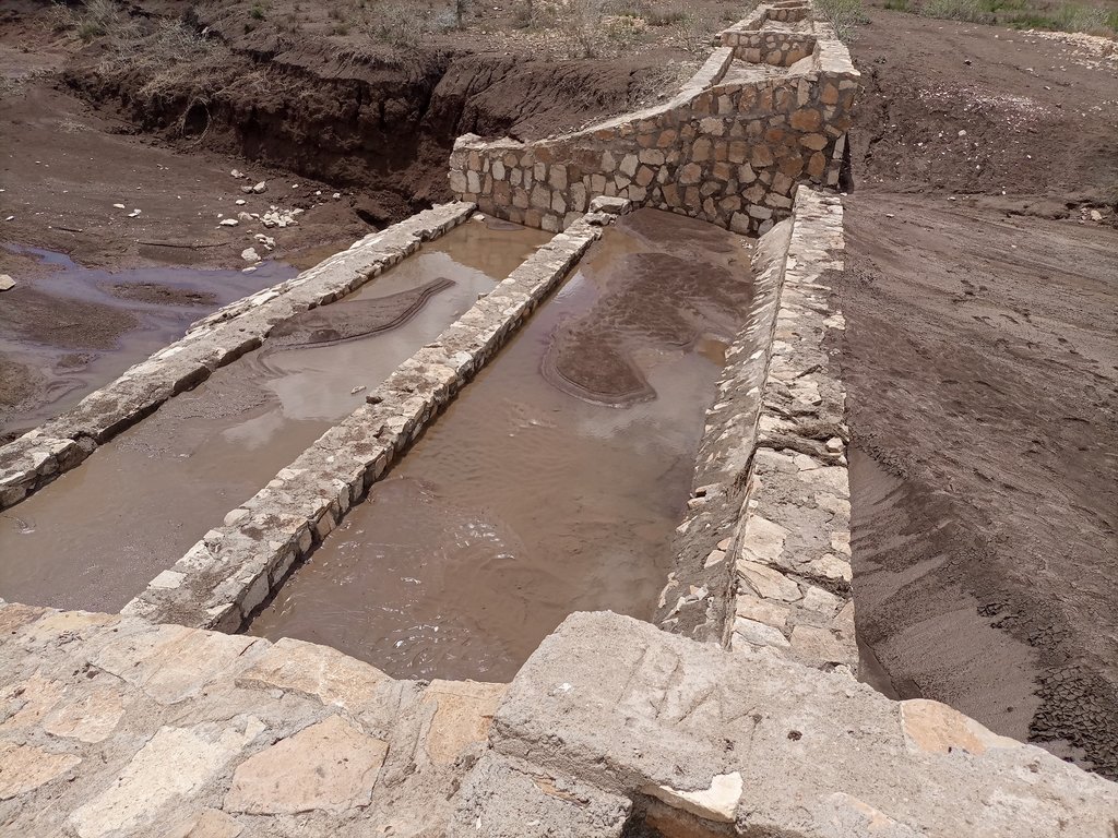
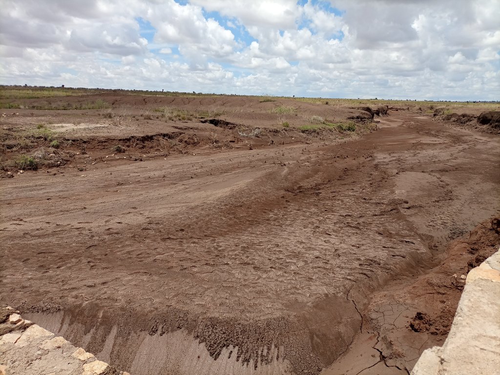
A “double basin masonry check dam” is a structure built in a narrow gully or depression to stop further gully formation. It is made of stone, concrete, gabions and wooden bars and serves as a permanent barrier. In this particular site stone is used as the structure is masonry. The technology is applied in areas where there are concentrated flows of water or runoff. The double basin masonry check dam is sited across a slope or a deep gully to slow water flow and capture sediment from upstream in the basins and behind the structure, thereby preventing expansion of the gully. The width of a check dam is variable. This particular structure is 14 meter wide, three meters deep and about 52 meters long. By helping to fill up the gully with sediment, it leads to rehabilitation and makes productive use of the area for growing trees, forage, and other plants. Apart from reducing the speed of surface runoff, the structure also promotes water infiltration, and recharges the groundwater reserves in the aquifer.
The main inputs necessary to build the check dams are financial resources, technical skills, skilled and unskilled labour, and construction materials including sand, stone, cement, water and other materials. Furthermore, construction tools such as a theodolite, line level, string, hammers, spades, hoes, and other tools are essential for design & construction. Technical skills for designing and profiling, and further capacity-building training are essential also. Application of the technology is also supported by satellite image and ground truthing to ensure the precision of siting.
The agropastoralists in the dry basin areas are pleased to see a huge movement of the soil arrested by the structure. The reduced expansion of the gully into the heart of the farm and grazing lands raises hopes of their land become productive and remaining so for generations to come. This hope and expectation have motivated them to welcome the intervention and develop an understanding of the actual benefits accrued from it. This leads to their support for the construction efforts. The disadvantages are that the technology is labour and resource-intensive which can be unaffordable for resource-poor agropastoralist communities living in food-insecure areas where rainfall is unreliable. This may make the adoption of the technology difficult to establish and nurture on their own without outside support.
2.3 صور التقنية
ملاحظات عامة بخصوص الصور:
The photos display a large amount of sediment captured by a few days' shower post recurrent droughts experienced in the area over the last two to three years.
2.4 فيديوهات عن التقنية
تعليقات، وصف موجز:
Video of the technology was not taken by this particular documentation exercise.
2.5 البلد/المنطقة/المواقع التي تم تنفيذ التقنية فيها والتي يغطيها هذا التقييم
البلد:
أثيوبيا
المنطقة/الولاية/المحافظة:
Somali
مزيد من التفاصيل حول الموقع:
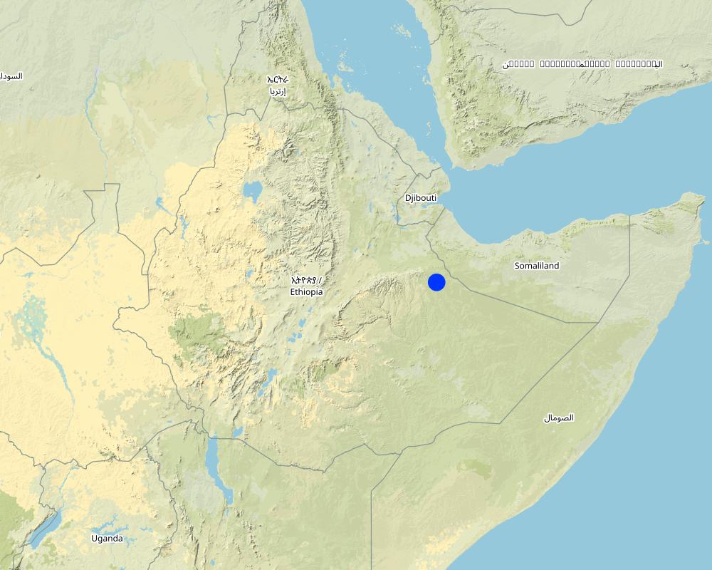
Hadow kebele of south Jigjiga district
حدد انتشار التقنية:
- يتم تطبيقها في نقاط محددة/ تتركز على مساحة صغيرة
هل يقع موقع/مواقع التقنية في منطقة محمية بشكل دائم؟:
كلا
التعليقات:
Locating the check dam closer to each other may help to stop the damage of heavy and concentrated flood moving in the drainage basin.
Map
×2.6 تاريخ التنفيذ
اذكر سنة التنفيذ:
2021
2.7 إدخال التقنية
حدد كيف تم إدخال التقنية:
- من خلال المشاريع/ التدخلات الخارجية
التعليقات (نوع المشروع، الخ):
Capacity Development and Strengthening Drought Resilience (CDSDR) project of the GIZ in Somali Region.
3. تصنيف تقنية الإدارة المستدامي للأراضي
3.1 الغرض الرئيسي ( الأغراض الرئيسية) للتقنية
- الحد من تدهور الأراضي ومنعه وعكسه
- الحفاظ على النظام البيئي
- حماية مستجمعات المياه / المناطق الواقعة في اتجاه مجرى النهر - مع تقنيات أخرى
- الحفاظ على/تحسين التنوع البيولوجي
- الحد من مخاطر الكوارث
3.2 نوع (أنواع) استخدام الأراضي الحالية حيث يتم تطبيق التقنية
استخدامات الأراضي مختلطة ضمن نفس وحدة الأرض:
كلا
3.3 هل تغير استخدام الأراضي نتيجة لتنفيذ التقنية؟
هل تغير استخدام الأراضي نتيجة لتنفيذ التقنية؟:
- لا (تابع مع السؤال 3.4)
3.4 إمدادات المياه
إمدادات المياه للأرض التي يتم تنفيذ التقنية عليها:
- بعلية
التعليقات:
Rainfed is the type of water supply that often experiences erratic distribution characterized by the reception of lower amounts. Mostly characterized by erratic and erosive feature.
3.5 مجموعةالإدارة المستدامة للأراضي التي تنتمي إليها هذه التقنية
- الرعي وإدارة المراعي
- التدابير المتقاطعة للمنحدرات
- حصاد المياه
3.6 التدابير التقنية في مجال إلادارة المستدامة للأراضي

التدابير البنيوية
- S6: الجدران والحواجز وسياجات القش، والسياجات
3.7 الأنواع الرئيسية من تدهور الأراضي التي تناولتها التقنية

تآكل التربة بالمياه
- الوزن(Wt): فقدان التربة السطحية/تآكل السطح
- (Wg):الانجراف الخلجاني/ الخلجان
- (Wm): مجموعة كبيرة من الحركات الأرضية/انزلاقات أرضية
3.8 منع أو حد أو عكس تدهور الأراضي
تحديد هدف التقنية فيما يتعلق بتدهور الأراضي:
- الحد من تدهور الأراضي
- اصلاح/إعادة تأهيل الأراضي المتدهورة بشدة
التعليقات:
The technology stops the mass movement of soil and water. As a result, it reduces land degradation, rehabilitates the degraded dry valley, and makes the land available for productive uses.
4. المواصفات الفنية، وأنشطة التنفيذ، والمدخلات، والتكاليف
4.1 الرسم الفني للتقنية
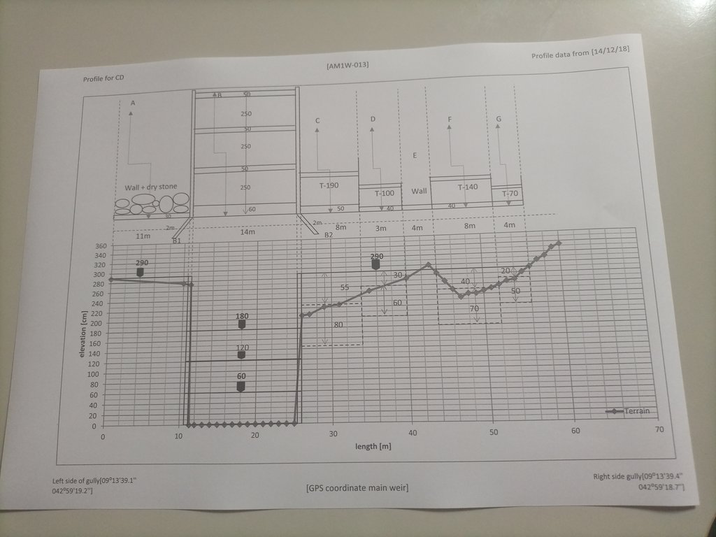
المواصفات الفنية (المتعلقة بالرسم الفني):
The design (layout - top view) and profile (lower view) of the technology is presented with universal units to clearly read and understand by the SLM experts or engineers. In addition, there are section drawings of the main weir and Bill of Quantity (BOQ).
المؤلف:
Amir Abdi
التاريخ:
14/12/2018
4.2 معلومات عامة بخصوص حساب المدخلات والتكاليف
حدد كيفية احتساب التكاليف والمدخلات:
- لكل وحدة تقنية
حدد الوحدة:
check dam
حدد أبعاد الوحدة (إذا كانت ذات صلة):
14m*3m*52m =2184m3
حدد العملة المستخدمة لحساب التكاليف:
- دولار أمريكي USD
اذكر متوسط تكلفة أجر العمالة المستأجرة في اليوم الواحد:
8.5 - 16 USD based on their skills
4.3 أنشطة التأسيس
| النشاط | التوقيت (الموسم) | |
|---|---|---|
| 1. | Conduct rapid assessment and Surveillance of intervention site | During the off-season |
| 2. | Finalize site selection | ditto |
| 3. | Layout, Design and profiling works | |
| 4. | Identify and train masonry workers | During off-season |
| 5. | Material supply | |
| 6. | Start actual layout and excavation work | |
| 7. | Supervision... |
التعليقات:
Once intended to put the technology or the structure in place, a series of activities are conducted involving experts and contract workers until the activities are effectively finalized.
4.4 التكاليف والمدخلات اللازمة للتأسيس
إذا لم تتمكن من تفصيل التكاليف في الجدول أعلاه، قم بتقديم تقدير للتكاليف الإجمالية لإنشاء التقنية:
9200,0
إذا تحمل مستخدم الأرض أقل من 100% من التكاليف، حدد من قام بتغطية التكاليف المتبقية:
The project is responsible to cover the cost.
التعليقات:
The cost for an unskilled casual laborer a day is 8.5 USD whereas the daily cost of a skilled Masonry worker is 16 USD per day.
4.5 الصيانة/الأنشطة المتكررة
| النشاط | التوقيت/الوتيرة | |
|---|---|---|
| 1. | Oversee and identify damage | During and after rainy season |
| 2. | Measure the degrees of damage | ditto |
| 3. | Quantify cost and materials needed | |
| 4. | Schedule the maintenance work | Right before the off-season |
| 5. | Employ the workers and reconstruct the damaged parts or upgrade it. | During off-season |
التعليقات:
As some of the technology implementation sites are inaccessible during the rainy season, implementing the activities during the off-season is commendable.
4.6 التكاليف والمدخلات اللازمة للصيانة/للأنشطة المتكررة (سنويًا)
إذا لم تتمكن من تفصيل التكاليف في الجدول أعلاه، قدم تقديرًا للتكاليف الإجمالية لصيانة التقنية:
3244,0
إذا تحمل مستخدم الأرض أقل من 100% من التكاليف، حدد من قام بتغطية التكاليف المتبقية:
The project is expected to cover the entire maintenance cost. However, maintenance cost is attributed to various factors including the degree of damage, material costs at the time, etc. The figure merely represents an estimation of the cost, on average.
التعليقات:
As the dry land receive erratic and erosive rain, damage to the structure is not uncommon. Combining fast-growing trees and deep-rooted perennial fodder grass stabilizes the sediment and reduces the speed of run-off on top of the structure. Therefore, associating the structure with biological barriers right after the first season of rain is a mandatory action that assists to reduce the damage and maintenance cost that is not affordable by resource-poor communities.
4.7 أهم العوامل المؤثرة على التكاليف
قدم وصفا لأهم العوامل التي تؤثر على التكاليف:
Inflation and increasingly changing material prices, labor and transportation costs.
5. البيئة الطبيعية والبشرية
5.1 المناخ
هطول الأمطار السنوي
- < 250 مم
- 251- 500 ملم
- 501 - 750ملم
- 1,000-751 ملم
- 1,500-1,100 ملم
- 2,000-1,500 ملم
- 3,000-2,001 ملم
- 4,000-3,100 ملم
- > 4000 ملم
المواصفات/التعليقات على هطول الأمطار:
Rainfall distribution is erratic and erosive.
الإشارة إلى اسم محطة الأرصاد الجوية المرجعية المعنية:
Jijiga Meteorology station
المنطقة المناخية الزراعية
- شبه قاحلة
There are bimodal rainfall patterns but the distribution in each respective season is not uniform. Particularly, the past consecutive seasons have been characterized by drought.
5.2 طوبوغرافيا
متوسط الانحدارات:
- مسطح (0-2%)
- بسيط (3-5%)
- معتدل (6-10%)
- متدحرج (11-15%)
- تلال (16-30%)
- شديدة الانحدار(31-60%)
- فائقة الانحدار (>60%)
التضاريس:
- هضاب/سهول
- أثلام مرتفعة
- المنحدرات الجبلية
- منحدرات التلال
- منحدرات في السفوح
- قاع الوادي
المنطقة الارتفاعية:
- 100-0 متر فوق سطح البحر
- 500-101 متر فوق سطح البحر
- 1,000-501 متر فوق سطح البحر
- 1,500-1,001 متر فوق سطح البحر
- 2,000-1,501 متر فوق سطح البحر
- 2,500-2,100 متر فوق سطح البحر
- 3,000-2,501 متر فوق سطح البحر
- 4,000-3,001 متر فوق سطح البحر
- > 4000 متر فوق سطح البحر
وضح ما إذا كانت التقنية مطبقة على وجه التحديد في:
- حالات مقعرة
التعليقات والمواصفات الإضافية بشأن التضاريس:
The technology is implemented in the gully or depression to reduce the speed of runoff and hold back the sediment and running water itself.
5.3 التربة
متوسط عمق التربة:
- ضحل جدًا (0-20 سم)
- ضحلة (21-50 سم)
- متوسطة العمق (51-80 سم)
- عميقة (81-120 سم)
- عميقة جدًا (> 120 سم)
قوام التربة (التربة السطحية):
- متوسط ( طميي، سلتي)
قوام التربة (> 20 سم تحت السطح):
- متوسط ( طميي، سلتي)
المواد العضوية في التربة السطحية:
- متوسطة (1-3%)
5.4 توافر المياه ونوعيتها
منسوب المياه الجوفية:
> 50 م
توافر المياه السطحية:
ضعيف/ غير متوافر
نوعية المياه (غير المعالجة):
مياه شرب جيدة
تشير جودة المياه إلى:
المياه الجوفية
هل تعتبر ملوحة الماء مشكلة؟:
نعم
حدد:
Land users communicated the presence of a medium level of water salinity.
هل تحدث فيضانات في المنطقة؟:
نعم
الإنتظام:
بشكل عرضي
تعليقات ومواصفات أخرى بشأن نوعية المياه وكميتها:
The water quality is a relative description as it is not supported by facts. Both livestock and human beings are using ponds and still water for drinking after rainfall.
5.5 التنوع البيولوجي
تنوع الأنواع:
- منخفض
تنوع الموائل:
- منخفض
التعليقات والمواصفات الإضافية بشأن التنوع البيولوجي:
A few tree and shrub species are common in the area. Acacia, opentia (Euphorbia species), and some invasive weed species are common.
5.6 خصائص مستخدمي الأراضي الذين يطبقون التقنية
مستقر أو مرتحل:
- شبه مرتحل
أخرى (حدد):
Agro-pastoralist
الدخل من خارج المزرعة:
- أقل من % 10من كامل الدخل
المستوى النسبي للثروة:
- ضعيف
أفراداً أو مجموعات:
- المجموعات/ المجتمع المحلي
مستوى المكننة:
- عمل يدوي
- الجر الحيواني
الجنس:
- نساء
- رجال
اذكر الخصائص الأخرى ذات الصلة لمستخدمي الأراضي:
The agro-pastoralist settlement pattern is stable except their mobility with their livestock looking for water and feed. Land users of various age groups are benefiting from the technology.
5.7 متوسط مساحة الأرض التي يستخدمها مستخدمو الأراضي الذين يطبقون التقنية
- < 0.5 هكتارا
- 0.5 - 1 هكتار
- 1 -2 هكتار
- 2 - 5 هكتار
- 5 - 15 هكتار
- 15 - 50 هكتار
- 50 - 100هكتار
- 500-100 هكتار
- 1,000-500 هكتار
- 10,000-1,000 هكتار
- > 10,000 هكتار
هل يعتبر هذا نطاقًا صغيرًا أو متوسطًا أو واسعا (في إشارة إلى السياق المحلي)؟:
- على نطاق صغير
5.8 ملكية الأراضي، وحقوق استخدام الأراضي، وحقوق استخدام المياه
ملكية الارض:
- مجتمعي/قروي
- فردية، لا يوجد سند ملكية
حقوق استخدام الأراضي:
- مجتمعي (منظم)
- فردي
حقوق استخدام المياه:
- مجتمعي (منظم)
- فردي
هل تعتمد حقوق استخدام الأراضي على نظام قانوني تقليدي؟:
نعم
حدد:
Land use is largely communal and individual inherit it from their lineage.
5.9 الوصول إلى الخدمات والبنية التحتية
الصحة:
- ضعيف
- معتدل
- جيد
التعليم:
- ضعيف
- معتدل
- جيد
المساعدة التقنية:
- ضعيف
- معتدل
- جيد
العمل (على سبيل المثال خارج المزرعة):
- ضعيف
- معتدل
- جيد
الأسواق:
- ضعيف
- معتدل
- جيد
الطاقة:
- ضعيف
- معتدل
- جيد
الطرق والنقل:
- ضعيف
- معتدل
- جيد
مياه الشرب وخدمات الصرف الصحي:
- ضعيف
- معتدل
- جيد
الخدمات المالية:
- ضعيف
- معتدل
- جيد
التعليقات:
Not much service is available in the pastoralist area except that the road paths through the area also create access to the market and other service centers.
6. الآثار والتصريحات الختامية
6.1 الآثار التي أظهرتها التقنية في الموقع
الآثار الاجتماعية والاقتصادية
الإنتاج
إنتاج الأعلاف
التعليقات/ حدد:
With the development of the sediments trapped by the structure by fodder crops of multipurpose tree species, it is possible to boost production and ensure the sustainability of the structure.
جودة العلف
التعليقات/ حدد:
As the sediment brings in fertile topsoil from the upstream catchments, the likelihood of producing quality fodder in the rehabilitated area is so high.
إنتاج الخشب
التعليقات/ حدد:
The multipurpose tree species assumed to be planted in the rehabilitated area are expected to increase wood production.
توافر المياه ونوعيتها
توافر مياه الشرب
التعليقات/ حدد:
As the rehabilitated valley reduces runoff and increases the groundwater reserves, it caters to the opportunity to access drinking water.
نوعية مياه الشرب
التعليقات/ حدد:
Succeeding vegetation covers enables to filter of the water and improves the quality of surface and subsurface water.
توافر المياه للماشية
التعليقات/ حدد:
Slightly increases as the structure and rehabilitated areas improves water infiltration and formation of still water or micro ponds behind the structure.
نوعية المياه للماشية
التعليقات/ حدد:
Simultaneously increases with the availability of surface and subsurface water.
الآثار الاجتماعية والثقافية
الأمن الغذائي / الاكتفاء الذاتي
التعليقات/ حدد:
Reduction of gully formations that consume the rangeland allows accessing relatively more rangeland areas for the livestock to graze over. This inevitably improves the food security of the pastoralist community.
المعرفة بالإدارة المستدامة للأراضي/تدهور الأراضي
التعليقات/ حدد:
The technology and its function along the mainstreaming work with local development actors certainly improve the understanding and evidence-based knowledge of the land users.
الآثار الايكولوجية
دورة المياه / الجريان السطحي
كمية المياه
التعليقات/ حدد:
The technology is believed to increase both surface and groundwater quantity in the intervention valley.
جودة المياه
الجريان السطحي
التعليقات/ حدد:
Surface runoff speed and volume are gradually decreased with the rehabilitation of the gully and the development of the area behind the structure.
تصريف المياه الزائدة
مستوى المياه الجوفية/ الطبقة المائية الجوفية
التربة
رطوبة التربة
التعليقات/ حدد:
Soil moisture in the rehabilitated area positively increased.
غطاء التربة
فقدان التربة
التعليقات/ حدد:
As the structure on the upstream side reduces the speed of runoff, soil, and water loss decrease, and soil accumulation is increasing over time.
تراكم التربة
تكون قشرة التربة السطحية/انسداد مسام التربة
التنوع البيولوجي: الغطاء النباتي، الحيوانات
الغطاء النباتي
التعليقات/ حدد:
It increases with the deposition of sediments. Seeds of different trees and vegetation can emerge as succession species.
التنوع النباتي
التعليقات/ حدد:
Increases!
الحد من مخاطر المناخ والكوارث
آثار الفيضانات
التعليقات/ حدد:
The structure and rehabilitated areas reduces the speed and impacts of the flood.
انزلاقات أرضية / تدفقات الحطام
آثار الجفاف
انبعاث الكربون والغازات المسببة للاحتباس الحراري
التعليقات/ حدد:
Overtime, tree cover reduces emission of carbon and green gases.
حدد تقييم الآثار في الموقع (القياسات):
Assessment of on-site impacts desires long-term follow-up, data collection, and analysis.
6.2 الآثار التي أظهرتها التقنية خارج الموقع
توافر المياه
التعليقات/ حدد:
As the technology put in place in recent times, off-site impacts need assessment based on facts.
الفيضان في اتجاه مجرى النهر
التعليقات/ حدد:
The structure and rehabilitated areas inevitably reduces downstream flooding and siltation in the future.
تراكم الطمي باتجاه مصب النهر
التعليقات/ حدد:
There is visible siltation held back by the structure. However, quantifying demands empirical analysis.
تلوث المياه الجوفية/الأنهار
القدرة على التخفيف / الترشيح
الأضرار التي لحقت بحقول الجيران
الضرر على البنية التحتية العامة/ الخاصة
آثار الغازات الدفيئة
قيّم الآثار خارج الموقع (القياسات):
The facts regarding the off-site impacts will certainly be assessed as a long-term impact.
6.3 تعرض التقنية وحساسيتها لتغير المناخ التدريجي والظواهر المتطرفة/الكوارث المرتبطة بالمناخ (كما يراها مستخدمو الأراضي)
تغير مناخ تدريجي
تغير مناخ تدريجي
| الموسم | زيادة أو نقصان | كيف تتعامل التقنية مع ذلك؟ | |
|---|---|---|---|
| درجة الحرارة السنوية | زيادة | باعتدال | |
| هطول الأمطار السنوي | انخفاض | باعتدال |
الظواهر المتطرفة / الكوارث المرتبطة بالمناخ
الكوارث الهيدرولوجية
| كيف تتعامل التقنية مع ذلك؟ | |
|---|---|
| فيضان عام (نهر) | غير معروف |
| فيضان مفاجئ | جيدة جدا |
| الانزلاق الأرضي | جيدا |
التعليقات:
Similar to on-site impacts, the off-site impact assessment needs, facts, and long-term follow-up.
6.4 تحليل التكلفة والعائد
كيف يمكن مقارنة العوائد نسبة لتكاليف الإنشاء (من وجهة نظر مستخدمي الأراضي)؟
عوائد قصيرة الأجل:
إيجابي
عوائد طويلة الأجل:
ايجابي جدا
كيف تتم مقارنة العوائدمع كلفة الصيانة/التكاليف المتكررة (من وجهة نظر مستخدمي الأراضي)؟
عوائد قصيرة الأجل:
إيجابي
عوائد طويلة الأجل:
ايجابي جدا
6.5 اعتماد التقنية
- حالات فردية/تجريبية
إذا كان متاحًا، قم بتحديد الكمية (عدد الأسر المعيشية و/أو المساحةالمغطاة):
Adoption rate is yet to be evaluated. The technology put in communal land.
التعليقات:
No community so far adopted and implemented the technology on its own.
6.6 التكيف
هل تم تعديل التقنية مؤخرًا لتتكيف مع الظروف المتغيرة؟:
كلا
6.7 نقاط القوة / المزايا / الفرص التي توفرها التقنية
| نقاط القوة/ المزايا/ الفرص من وجهة نظر مستخدمي الأراضي |
|---|
| Rehabilitate the gully, and stop and reverse the gully formation. |
| It creates the opportunity for productive use of the degraded environment. |
| Recharge the groundwater aquifer and supply still water for temporary use by local people and livestock. |
| نقاط القوة/ المزايا/ الفرص من وجهة نظر جامع المعلومات أو غيره من الاشخاص الرئيسيين لمصدر المعلومات |
|---|
| Promote regeneration of the lost species through resilience building. |
| Improve the landscape feature. |
| Improve the ecosystem and its overall services. |
6.8 نقاط ضعف / مساوىء / مخاطر التقنية وسبل التغلب عليها
| نقاط الضعف/ المساوىء/ المخاطر من وجهة نظر مستخدم الأراضي | كيف يمكن التغلب عليها؟ |
|---|---|
| High investment cost to implement the technology. | Promote government awareness and emphasis on the benefit and investment in developing the technology. |
| Lack of implementation skills. | Develop the skills and motivation of the community and other stakeholders. |
| Conflict of interest on the use of the rehabilitated land in the intersection of neighboring kebeles. | Awareness creation and promote behavioral change on the joint benefit of the technology. |
| نقاط الضعف/ المساوىء/ المخاطر من وجهة نظر جامع المعلومات أو غيره من الاشخاص الرئيسيين لمصدر المعلومات | كيف يمكن التغلب عليها؟ |
|---|---|
| Inability to put micro check dams along the drainage line before it cuts deep into the soil. | Improve surveillance and promote early intervention. |
| Lower level of participation from the land users. | Develop the capacity, awareness and motivation of the land users. |
| Stakeholders and land users lower level of environmental education, improper land management and the consequent climate change and other associated adversities. | Promote environmental education, emerging climate change and climate variability in adult and vocational education. |
7. المراجع والروابط
7.1 طرق جمع/مصادر المعلومات
- زيارات ميدانية، مسوحات ميدانية
Four individuals
- مقابلات مع المتخصصين/الخبراء في الإدارة المستدامة للأراضي
Two individuals.
متى تم تجميع البيانات (ميدانيا)؟:
23/03/2023
التعليقات:
The flash flood post three years of drought is so damaging. The fragile soil that has been exposed to the sun is easily detached and moved away by the flood. Substantial tons of soil stopped by the check dam signals the positive effects of the structure in changing the trends.
7.2 المراجع للمنشورات المتاحة
العنوان، المؤلف، السنة، النظام القياسي الدولي لترقيم الكتب ISBN:
Criteria for optimizing check dam location and maintenance requirements. Hassanli, A. M. & Beecham. 2013; ISBN: 971-1-60876-146-3
متاح من أين؟كم التكلفة؟:
https://www.researchgate.net/publication/287636490_Criteria_for_optimizing_check_dam_location_and_maintenance_requirements
7.3 روابط للمعلومات ذات الصلة على الإنترنت
العنوان/الوصف:
Different Types of Check Dams & Design Procedures
عنوان الرابط URL:
https://forestrybloq.com/different-types-of-check-dams/
7.4 تعليقات عامة
The questionnaire is comprehensive. However, to answer every question, there must be a tradition of long-term data collection and documentation exercises by either the project or the partners government organizations. In that way, it is possible to fully address the multifaceted demands included in the questionnaires such as " the before and after SLM intervention" which is dire to address them for those projects at their early stages of implementation.
الروابط والوحدات المواضيعية
توسيع الكل طي الكلالروابط
لا يوجد روابط
الوحدات المواضيعية
لا يوجد وحدات مواضيعية


