Soil Bund with Contour Cultivation [Ethiopia]
- Creation:
- Update:
- Compiler: Unknown User
- Editor: –
- Reviewers: Fabian Ottiger, Alexandra Gavilano
Ditchira, Kab (Amharic)
technologies_1073 - Ethiopia
View sections
Expand all Collapse all1. معلومات عامة
1.2 Contact details of resource persons and institutions involved in the assessment and documentation of the Technology
Key resource person(s)
SLM specialist:
Tafese Berhanu
Hadiya zone
Ethiopia
SLM specialist:
Watchiso Adibacho
Hadiya zone
Ethiopia
1.3 Conditions regarding the use of data documented through WOCAT
The compiler and key resource person(s) accept the conditions regarding the use of data documented through WOCAT:
نعم
2. Description of the SLM Technology
2.1 Short description of the Technology
Definition of the Technology:
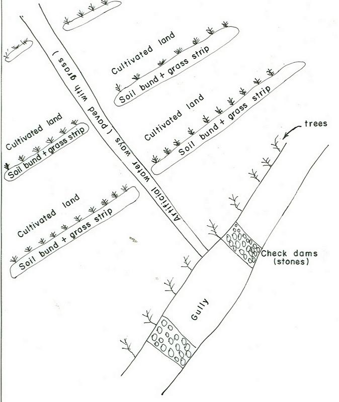
It is a structural measure with an embankment of soil or stones or soil and stones, constructed along the contour and stablized with vegetative measures (grass and fodder trees).
2.2 Detailed description of the Technology
Description:
Applied on different land uses on slope of more than 3%. This practice is widely used by farmers in the area. Stone and stone faced bunds height depends on the availability of stones. On the average the width is 1-1.2m and hieght is 0.6-0.7m.
Purpose of the Technology: Bunds reduce the velocity of runoff and soil erosion, retains water behind the bund and let it infiltrate. It further helps in ground water recharging.
Establishment / maintenance activities and inputs: Planning is made by community/group and individual discussion and reach a consensus on layout, spacing, implementation modalities and management requirments is reached before implementation.
Natural / human environment: The technology is applicable in areas where soil is moderately deep and stones are available
2.3 Photos of the Technology
Media Gallery
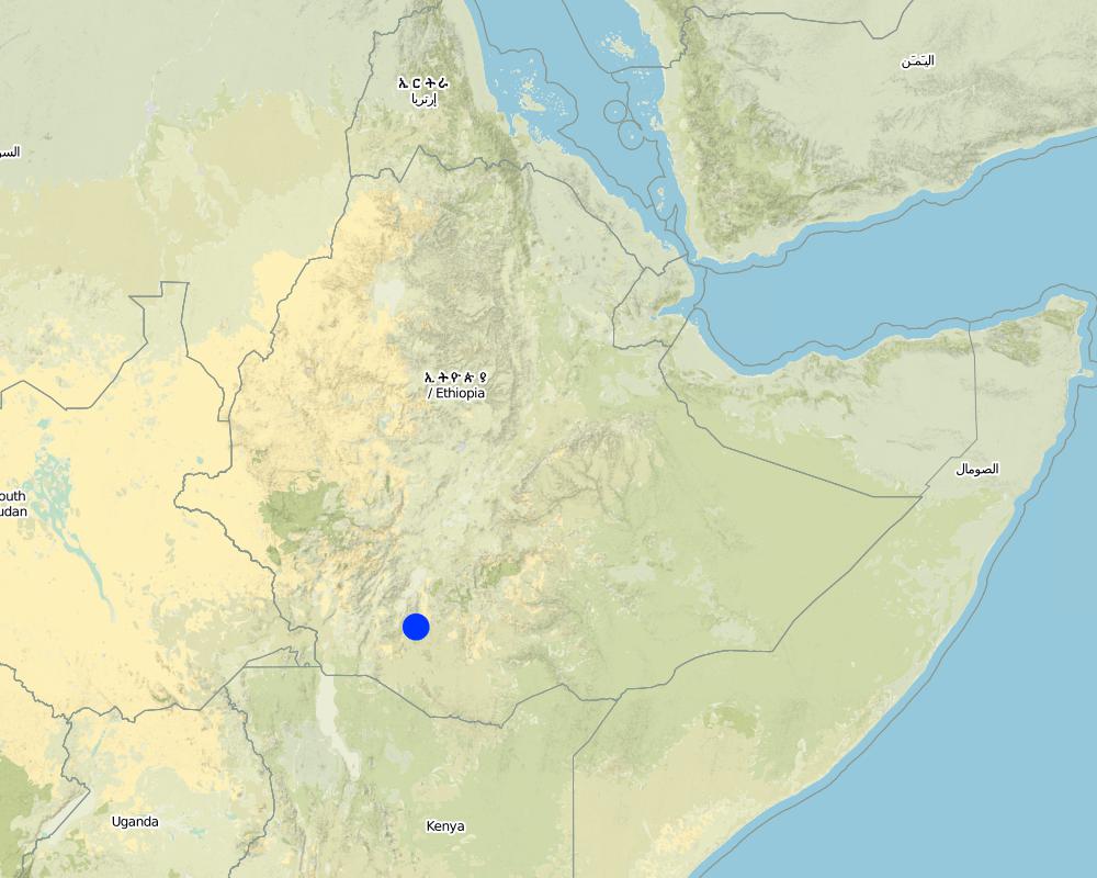
2.5 Country/ region/ locations where the Technology has been applied and which are covered by this assessment
بلد:
Ethiopia
Region/ State/ Province:
SNNPR/Hadiya/Lemo
Further specification of location:
Lemo
Comments:
Total area covered by the SLM Technology is 173 km2.
Nowadays communities have developed positive attitudes towards SWC technologies implemented and the results obtained by practicing measures, which have reduced runoff and soil erosion reduced and land increased productivity.
Map
×2.6 Date of implementation
If precise year is not known, indicate approximate date:
- more than 50 years ago (traditional)
2.7 Introduction of the Technology
Specify how the Technology was introduced:
- through projects/ external interventions
Comments (type of project, etc.):
Other countries and also other woredas in the country.
3. Classification of the SLM Technology
3.2 Current land use type(s) where the Technology is applied

الأراضي الزراعية
- Annual cropping
- Perennial (non-woody) cropping
- Tree and shrub cropping
Annual cropping - Specify crops:
- cereals - maize
- cereals - other
- cereals - sorghum
- legumes and pulses - other
- root/tuber crops - potatoes
- vegetables - leafy vegetables (salads, cabbage, spinach, other)
- wheat, haricot beans
Perennial (non-woody) cropping - Specify crops:
- sugar cane
- Enset, Desho, Phalaris
Tree and shrub cropping - Specify crops:
- avocado
- coffee, open grown
- mango, mangosteen, guava
- papaya
- Cordia, Croton, Ficus, Casmir
Number of growing seasons per year:
- 2
حددها:
Longest growing period in days: 180 Longest growing period from month to month: Apr - Nov Second longest growing period in days: 150
Is intercropping practiced?
نعم
If yes, specify which crops are intercropped:
maize + haricot beans
coffee + cabbage

Forest/ woodlands
- Tree plantation, afforestation
Products and services:
- Timber
- Fuelwood
- Grazing/ browsing
Comments:
Major land use problems (compiler’s opinion): Absence of land use policy, low level of awarness, shortage of farm lands.
Major land use problems (land users’ perception): Continous cultivation, poor soil fertility, poverty, shortage of cultivated lands.
Plantation forestry: Yes
Problems / comments regarding forest use: Many peasant kebeles have earned money by selling eucalyptus grown on plantation areas of the community. Some have built schools from the proceeds. Some kebeles have shared sizable money from the sales of trees.
Type of cropping system and major crops comments: Cereals - legumes - cereals
3.3 Has land use changed due to the implementation of the Technology?
Land use mixed within the same land unit:
نعم

أراضي الرعي
Intensive grazing/ fodder production:
- Cut-and-carry/ zero grazing
3.4 Water supply
Water supply for the land on which the Technology is applied:
- rainfed
3.5 SLM group to which the Technology belongs
- cross-slope measure
3.6 SLM measures comprising the Technology

agronomic measures
- A2: Organic matter/ soil fertility
- A3: Soil surface treatment
Comments:
Main measures: structural measures
Secondary measures: agronomic measures, vegetative measures, management measures
Type of agronomic measures: early planting, mixed cropping / intercropping, legume inter-planting, manure / compost / residues, breaking compacted topsoil, contour tillage
Type of vegetative measures: aligned: -contour, scattered / dispersed
3.7 Main types of land degradation addressed by the Technology

soil erosion by water
- Wt: loss of topsoil/ surface erosion
- Wg: gully erosion/ gullying

chemical soil deterioration
- Cn: fertility decline and reduced organic matter content (not caused by erosion)
Comments:
Main type of degradation addressed: Wt: loss of topsoil / surface erosion
Secondary types of degradation addressed: Wg: gully erosion / gullying, Cn: fertility decline and reduced organic matter content
3.8 Prevention, reduction, or restoration of land degradation
Specify the goal of the Technology with regard to land degradation:
- prevent land degradation
- reduce land degradation
Comments:
Secondary goals: Rehabilitation / reclamation of denuded land
4. Technical specifications, implementation activities, inputs, and costs
4.1 Technical drawing of the Technology
Technical specifications (related to technical drawing):
SNNPR
Technical knowledge required for field staff / advisors: high
Technical knowledge required for land users: moderate
Main technical functions: control of dispersed runoff: retain / trap, control of dispersed runoff: impede / retard, increase of infiltration
Secondary technical functions: reduction of slope angle, reduction of slope length, increase / maintain water stored in soil
Early planting
Material/ species: maize, potato
Remarks: row and broad casting
Mixed cropping / intercropping
Material/ species: sorghum + haricot beans
Remarks: row planting
Agronomic measure: mixed cropping / intercropping
Material/ species: maize + haricot beans
Remarks: row planting
Agronomic measure: mixed cropping / intercropping
Material/ species: coffee + cabbage
Remarks: row planting
Legume inter-planting
Remarks: row and broad casting
Manure / compost / residues
Material/ species: animal dung
Remarks: broad casting
Breaking compacted topsoil
Remarks: once, along the contour
Contour tillage
Remarks: 3-6 times, along the contour
Aligned: -contour
Vegetative material: G : grass
Vertical interval between rows / strips / blocks (m): 1m
Vertical interval within rows / strips / blocks (m): 0.3
Width within rows / strips / blocks (m): 1
Scattered / dispersed
Vegetative material: T : trees / shrubs
Number of plants per (ha): 10-15
Vegetative measure: scattered/dispersed
Vegetative material: F : fruit trees / shrubs
Number of plants per (ha): 40-60
Vegetative measure: Vegetative material: F : fruit trees / shrubs
Vegetative measure: Vegetative material: F : fruit trees / shrubs
Vegetative measure: Vegetative material: F : fruit trees / shrubs
Trees/ shrubs species: Cordia, Croton, Ficus
Fruit trees / shrubs species: Casmir, Avocado, Mango
Perennial crops species: Chat, Coffee, Sugar cane, Papaya
Grass species: Desho, Phalaris
Slope (which determines the spacing indicated above): 15.00%
If the original slope has changed as a result of the Technology, the slope today is (see figure below): 10.00%
Gradient along the rows / strips: 0.00%
Terrace: bench level
Vertical interval between structures (m): 1
Spacing between structures (m): 10
Depth of ditches/pits/dams (m): 0.5
Width of ditches/pits/dams (m): 0.3
Length of ditches/pits/dams (m): 1
Height of bunds/banks/others (m): 0.6-0.7
Width of bunds/banks/others (m): 1-1.2
Length of bunds/banks/others (m): 60-80
Construction material (earth): Soils excavated from the ditches is used to make the embankment.
Construction material (stone): Stones collected to construct stone/stone faced bunds.
Slope (which determines the spacing indicated above): 15%
If the original slope has changed as a result of the Technology, the slope today is: 10%
Lateral gradient along the structure: 0%
Vegetation is used for stabilisation of structures.
Change of land use type: cut and carry system practiced
Other type of management: change of management / intensity level - Follow up and evaluating the performance
4.2 General information regarding the calculation of inputs and costs
other/ national currency (specify):
Birr
If relevant, indicate exchange rate from USD to local currency (e.g. 1 USD = 79.9 Brazilian Real): 1 USD =:
8,6
Indicate average wage cost of hired labour per day:
0.70
4.3 Establishment activities
| Activity | Timing (season) | |
|---|---|---|
| 1. | Production of planting materials | beginning of rains |
| 2. | Planting on the bund | during rains |
| 3. | Survey | dry season |
| 4. | Excavating the ditches and constructing the enbankment | dry season |
| 5. | desho grass transportation | during rains |
| 6. | Planting Desho grass on the bund | during rains |
| 7. | Group formation | dry season |
| 8. | Follow up and evaluating the activities | throughout the year |
4.4 Costs and inputs needed for establishment
| Specify input | Unit | Quantity | Costs per Unit | Total costs per input | % of costs borne by land users | |
|---|---|---|---|---|---|---|
| Labour | Labour | ha | 1,0 | 156,0 | 156,0 | 5,0 |
| Equipment | Machine use | ha | 1,0 | 27,8 | 27,8 | |
| Equipment | Tools | ha | 1,0 | 32,1 | 32,1 | 70,0 |
| Plant material | Seeds | ha | 1,0 | 27,0 | 27,0 | 100,0 |
| Plant material | Seedlings | ha | 1,0 | 29,0 | 29,0 | 100,0 |
| Other | Grass | ha | 1,0 | 306,0 | 306,0 | 100,0 |
| Total costs for establishment of the Technology | 577,9 | |||||
| Total costs for establishment of the Technology in USD | 67,2 | |||||
Comments:
Duration of establishment phase: 24 month(s)
4.5 Maintenance/ recurrent activities
| Activity | Timing/ frequency | |
|---|---|---|
| 1. | Contour tillage | dry season / annual |
| 2. | Contour tillage | dry season / two to three times |
| 3. | Sawing | during rains / annual |
| 4. | Weeding | during rains / one or twice a year |
| 5. | Harvesting | dry season / annual |
| 6. | Replanting | during rains /once |
| 7. | Reconstruction | dry season/annual |
| 8. | Replanting | rainy season/annual |
4.6 Costs and inputs needed for maintenance/ recurrent activities (per year)
| Specify input | Unit | Quantity | Costs per Unit | Total costs per input | % of costs borne by land users | |
|---|---|---|---|---|---|---|
| Labour | Labour | ha | 1,0 | 18,84 | 18,84 | 100,0 |
| Equipment | Machine use | ha | 1,0 | 81,39 | 81,39 | 100,0 |
| Total costs for maintenance of the Technology | 100,23 | |||||
| Total costs for maintenance of the Technology in USD | 11,65 | |||||
Comments:
Machinery/ tools: Shovel, hoe, water level, string
The cost is culculated per length of structure and other agricultural activities undertaken and the cost is in a hectare of land.
4.7 Most important factors affecting the costs
Describe the most determinate factors affecting the costs:
Type of hand tools, Slope of the land and soil depth.
5. Natural and human environment
5.1 Climate
Annual rainfall
- < 250 mm
- 251-500 mm
- 501-750 mm
- 751-1,000 mm
- 1,001-1,500 mm
- 1,501-2,000 mm
- 2,001-3,000 mm
- 3,001-4,000 mm
- > 4,000 mm
Specifications/ comments on rainfall:
1001-1500 mm (Ranked 1): 900-1400 mm, rains are tremendously variable.
751-1000 mm (Ranked 2): 900 mm, Parts of the SWC area receives on an average 900 mm.
Agro-climatic zone
- sub-humid
Very suitable to agricultural activities with variety crops grown.
5.2 Topography
Slopes on average:
- flat (0-2%)
- gentle (3-5%)
- moderate (6-10%)
- rolling (11-15%)
- hilly (16-30%)
- steep (31-60%)
- very steep (>60%)
Landforms:
- plateau/plains
- ridges
- mountain slopes
- hill slopes
- footslopes
- valley floors
Altitudinal zone:
- 0-100 m a.s.l.
- 101-500 m a.s.l.
- 501-1,000 m a.s.l.
- 1,001-1,500 m a.s.l.
- 1,501-2,000 m a.s.l.
- 2,001-2,500 m a.s.l.
- 2,501-3,000 m a.s.l.
- 3,001-4,000 m a.s.l.
- > 4,000 m a.s.l.
Comments and further specifications on topography:
Altitudinal zone: 2001-2500 m a.s.l. (Ranked 1, below 2400m asl, very suitable to wheat, barley and horse beans.) and 1501-2000 m a.s.l. (ranked 2, over 1900m asl, very suitable to cereal crops including maize)
Landforms: Hill slopes (ranked 1, dominant land forms with flatter village areas at the top) also, ridges (ranked 2) and plateau/plains (ranked 3)
Slopes on average: Rolling (Ranked 1, the technology is mostly implemented here), moderate (ranked 2, dominantly cultivated) and hilly (ranked 3, area enclosures) as well as gentle and steep (both ranked 3)
5.3 Soils
Soil depth on average:
- very shallow (0-20 cm)
- shallow (21-50 cm)
- moderately deep (51-80 cm)
- deep (81-120 cm)
- very deep (> 120 cm)
Soil texture (topsoil):
- medium (loamy, silty)
- fine/ heavy (clay)
Topsoil organic matter:
- medium (1-3%)
- low (<1%)
If available, attach full soil description or specify the available information, e.g. soil type, soil PH/ acidity, Cation Exchange Capacity, nitrogen, salinity etc.
Soil depth on average: Also moderately deep (ranked 2, dominant soil depth in the SWC area) and shallow (ranked 3, degraded hillsides)
Soil texture: Fine/heavy (ranked 1, clay loam nitisols and vertisols) and medium (ranked 2, soils with high productivity)
Soil fertility: medium (ranked 1, most of the cereal cropped areas) and high (ranked 2, soils in the homestead)
Topsoil organic matter: Low (ranked 1, for all cereal cropped lands) and medium (ranked 2, land with perennial crops and homestead areas)
Soil drainage/infiltration: good (ranked 1, croplands on hillslopes ) and medium (ranked 2)
Soil water storage capacity: High (vertisols and soils on flat slopes)
5.6 Characteristics of land users applying the Technology
Off-farm income:
- less than 10% of all income
Relative level of wealth:
- poor
- average
Level of mechanization:
- manual work
- animal traction
Indicate other relevant characteristics of the land users:
Population density: 200-500 persons/km2
Annual population growth: 2% - 3%
6% of the land users are rich and own 19% of the land.
35% of the land users are average wealthy and own 45% of the land.
45% of the land users are poor and own 15% of the land.
12% of the land users are poor and own 7% of the land.
Off-farm income specification: Land users who have SWC measures on their land have better income compared to others who do not have and they have better scope to get engaged in small trade.
Market orientation of production system: subsistence (cultivation and weeding of perennial crops done by hoe and weeding manual) and mixed (tillage is done by oxen)
5.7 Average area of land used by land users applying the Technology
- < 0.5 ha
- 0.5-1 ha
- 1-2 ha
- 2-5 ha
- 5-15 ha
- 15-50 ha
- 50-100 ha
- 100-500 ha
- 500-1,000 ha
- 1,000-10,000 ha
- > 10,000 ha
Comments:
Most land users have 0.50-0.25 ha of land.
5.8 Land ownership, land use rights, and water use rights
Land ownership:
- state
Land use rights:
- individual
6. Impacts and concluding statements
6.1 On-site impacts the Technology has shown
Socio-economic impacts
Production
crop production
Comments/ specify:
soil loss reduced, fertilizers loss controlled
fodder production
Comments/ specify:
bund stablization increased feed availability
fodder quality
Comments/ specify:
bund stablization increased feed availability
wood production
Comments/ specify:
tree plantation
production area
Comments/ specify:
area occupied by the bund
Income and costs
farm income
Comments/ specify:
production per unit area increased
Socio-cultural impacts
community institutions
Comments/ specify:
SWC activities organized and planned by communities
national institutions
Comments/ specify:
government & NGOs involvement increased
SLM/ land degradation knowledge
Comments/ specify:
more land users acquired knowledge on SWC
Ecological impacts
Water cycle/ runoff
excess water drainage
Soil
soil moisture
soil cover
Comments/ specify:
uphills planted with forest trees
soil loss
Quantity before SLM:
82
Quantity after SLM:
8
Comments/ specify:
integrated measures
6.4 Cost-benefit analysis
How do the benefits compare with the establishment costs (from land users’ perspective)?
Short-term returns:
slightly positive
Long-term returns:
positive
How do the benefits compare with the maintenance/ recurrent costs (from land users' perspective)?
Short-term returns:
slightly positive
Long-term returns:
positive
6.5 Adoption of the Technology
Of all those who have adopted the Technology, how many did so spontaneously, i.e. without receiving any material incentives/ payments?
- 0-10%
Comments:
10% of land user families have adopted the Technology with external material support
25600 land user families have adopted the Technology with external material support
Comments on acceptance with external material support: estimates
5% of land user families have adopted the Technology without any external material support
Comments on spontaneous adoption: estimates
There is a moderate trend towards spontaneous adoption of the Technology
Comments on adoption trend: Farmers have acquired some technical skills that enables them implement SWC measures by themselves on their own land with little external support.
6.7 Strengths/ advantages/ opportunities of the Technology
| Strengths/ advantages/ opportunities in the land user’s view |
|---|
|
increased crop production How can they be sustained / enhanced? use high yielding varities and better farming systems. |
| soil erosion reduced |
| Strengths/ advantages/ opportunities in the compiler’s or other key resource person’s view |
|---|
|
soils protected from erosion How can they be sustained / enhanced? more awarness creation and strengthening maintenance |
|
sources of income diversified How can they be sustained / enhanced? introduce more productive multipurposive activities |
7. References and links
7.1 Methods/ sources of information
Links and modules
Expand all Collapse allLinks
No links
Modules
No modules