Riparian buffer strips [سلوفينيا]
- تاريخ الإنشاء:
- تحديث:
- جامع المعلومات: Gregor Kramberger
- المحرر: Tamara Korošec
- المراجعون: William Critchley, Rima Mekdaschi Studer
Varovalni pasovi ob vodotokih
technologies_6246 - سلوفينيا
عرض الأقسام
توسيع الكل طي الكل1. معلومات عامة
1.2 تفاصيل الاتصال بالأشخاص الرئيسيين لمصدر المعلومات والمؤسسات المشاركة في تقييم وتوثيق التقنية
متخصص في الإدارة المستدامة للأراضي:
متخصص في الإدارة المستدامة للأراضي:
Horvat Timotej
Chamber of Agriculture and Forestry of Slovenia (KGZS) – Institute of Agriculture and Forestry Maribor Slovenia
سلوفينيا
جامع المعلومات المشارك:
Ropič Andrej
Farmer
سلوفينيا
متخصص في الإدارة المستدامة للأراضي:
Kep Tina
Chamber of Agriculture and Forestry of Slovenia (KGZS) – Institute of Agriculture and Forestry Maribor Slovenia
سلوفينيا
اسم المشروع الذي سهّل توثيق/تقييم التقنية (إذا كان ذلك على صلة)
OPtimal strategies to retAIN and re-use water and nutrients in small agricultural catchments across different soil-climatic regions in Europe (OPTAIN)اسم المؤسسة (المؤسسات) التي سهلت توثيق/تقييم التقنية (إذا كان ذلك على صلة)
Chamber of Agriculture and Forestry of Slovenia – Institute of Agriculture and Forestry Maribor (KGZS) - سلوفينيا1.3 الشروط المتعلقة باستخدام البيانات الموثقة من خلال WOCAT
يوافق جامع المعلومات والشخص (لاشخاص) الرئيسي لمصدر المعلومات على الشروط المتعلقة باستخدام البيانات الموثقة من خلال WOCAT:
نعم
1.4 إعلان بشأن استدامة التقنية الموصوفة
هل التقنية الموصوفة هنا تمثل مشكلة فيما يتعلق بتدهور الأراضي، بحيث لا يمكن إعلانها تقنية مستدامة لإدارة الأراضي؟:
كلا
2. وصف تقنيةالإدارة المستدامي للأراضي
2.1 وصف مختصر للتقنية
تعريف التقنية:
Riparian buffer strips are vegetative zones alongside watercourses. In compliance with EU and Slovenia’s Acts, these protective strips reduce soil erosion, filter pollutants, improve water quality, enhance biodiversity and support climate resilience.
2.2 وصف تفصيلي للتقنية
الوصف:
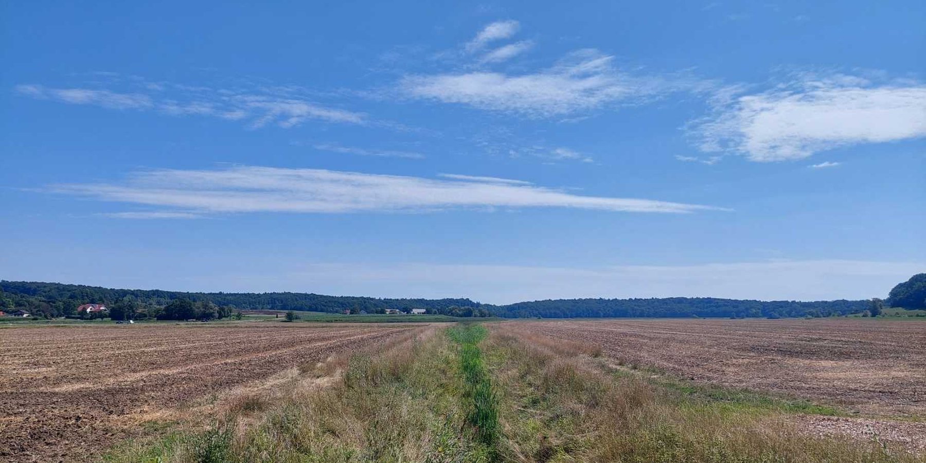
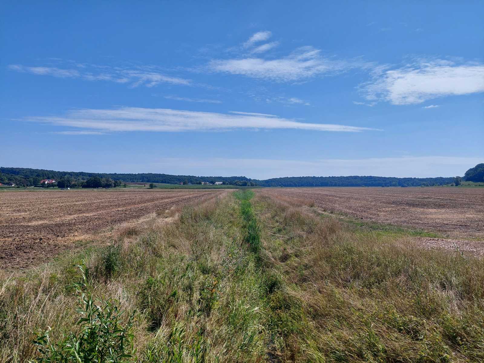
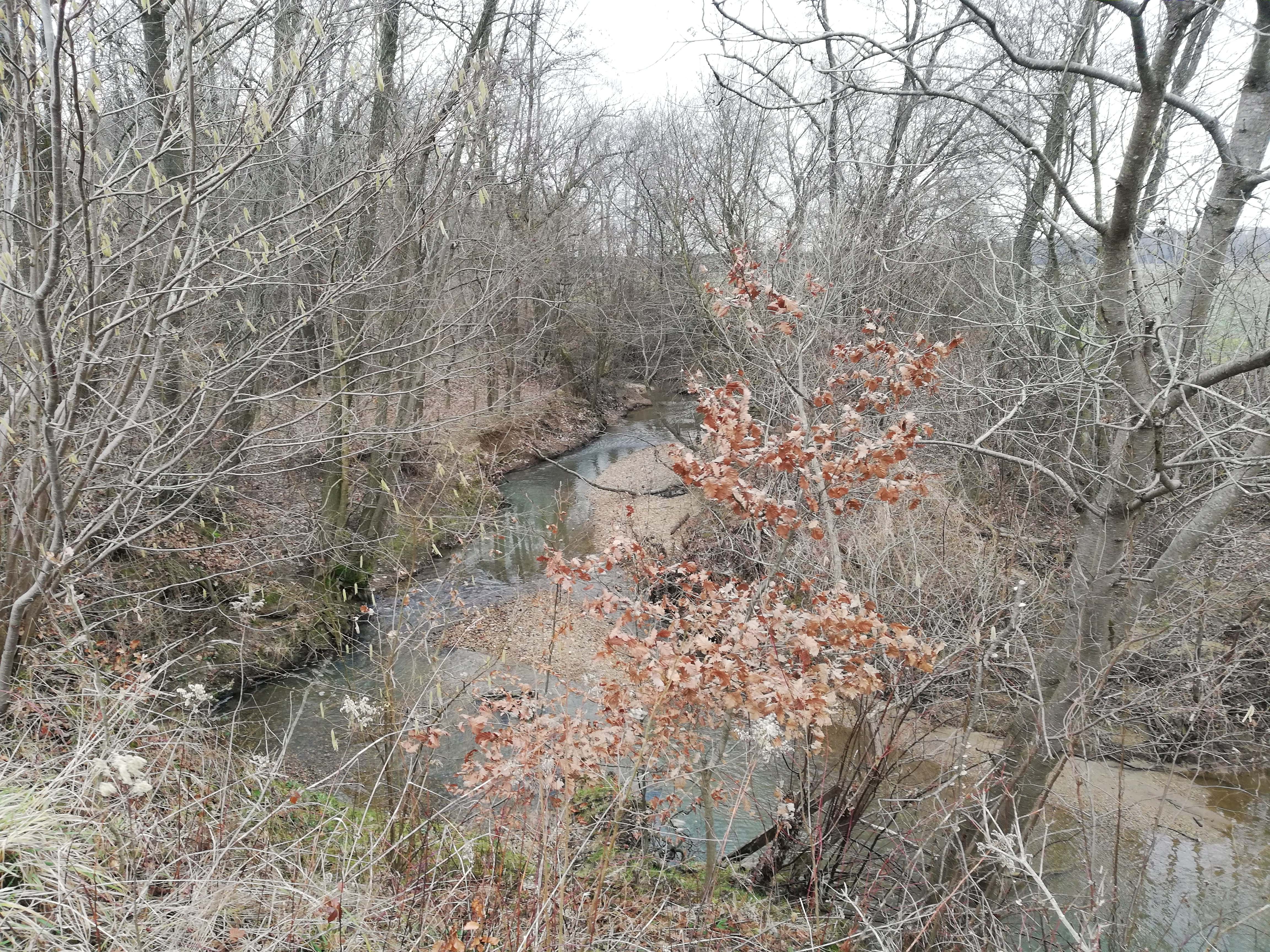
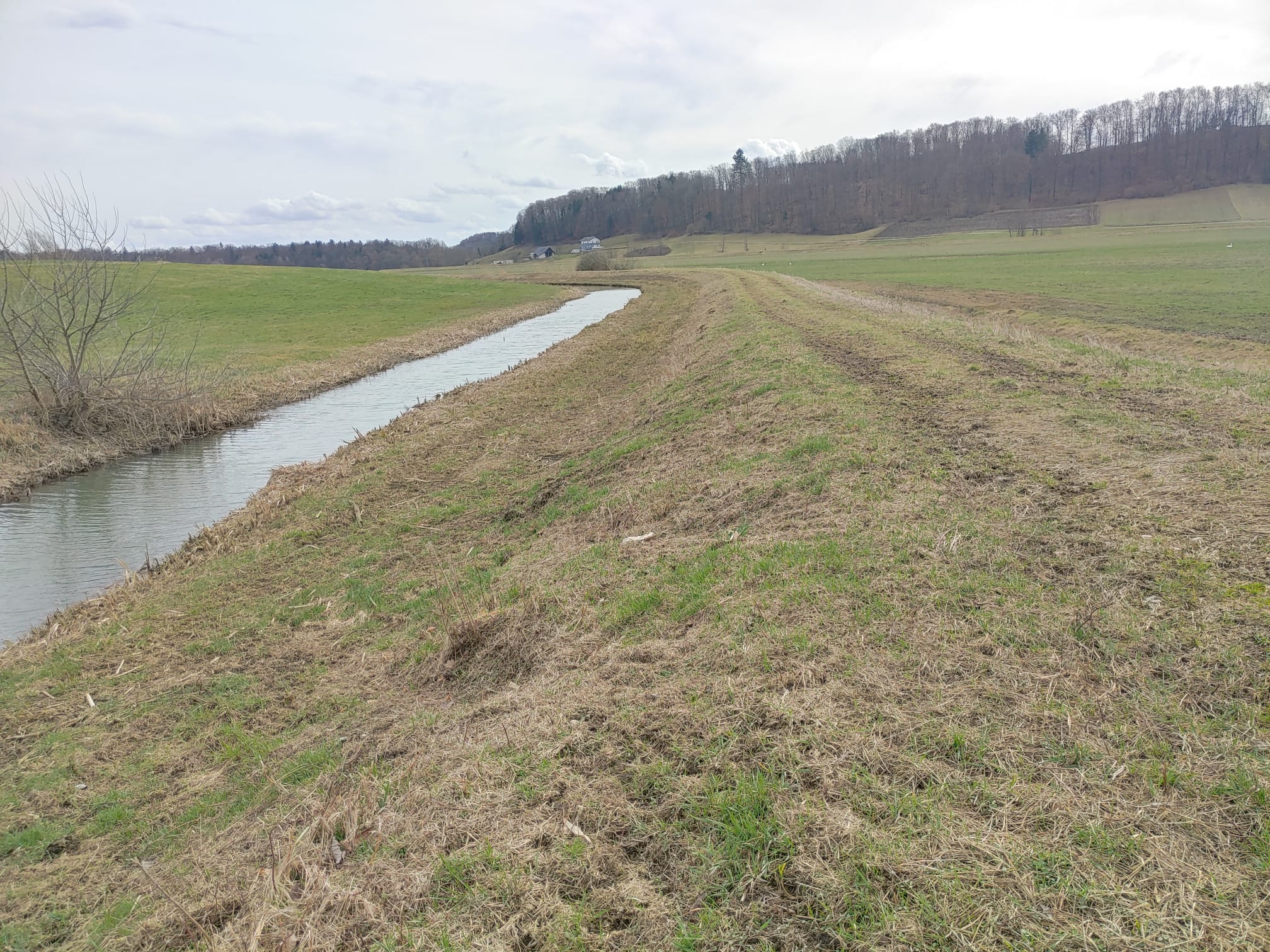
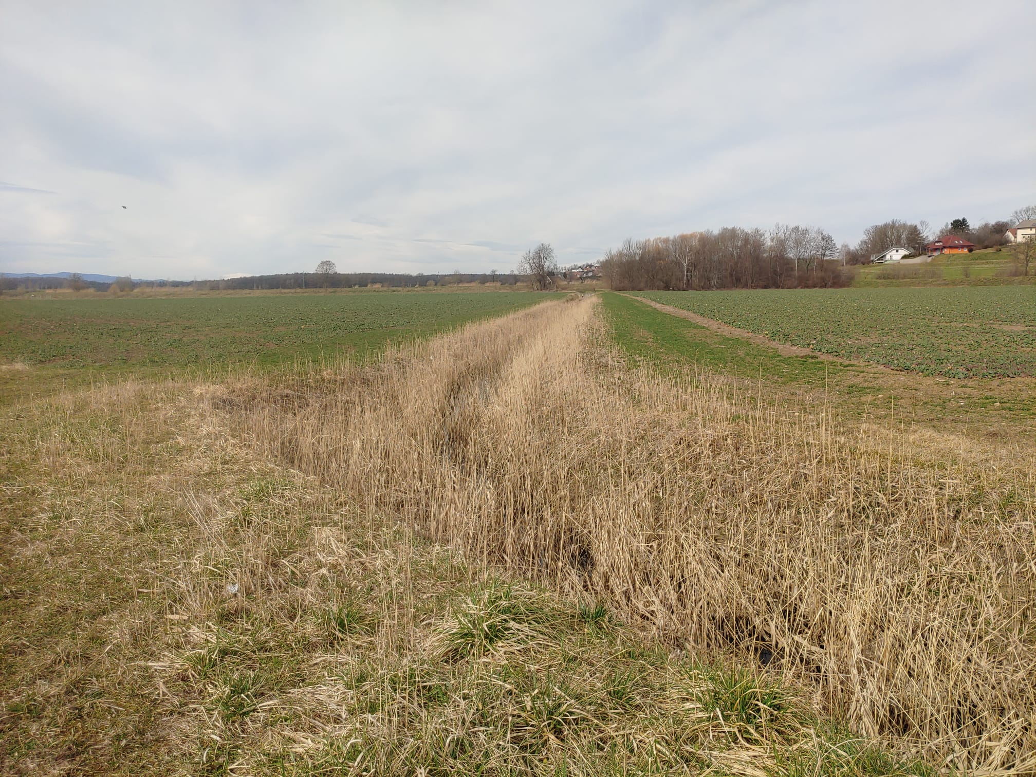
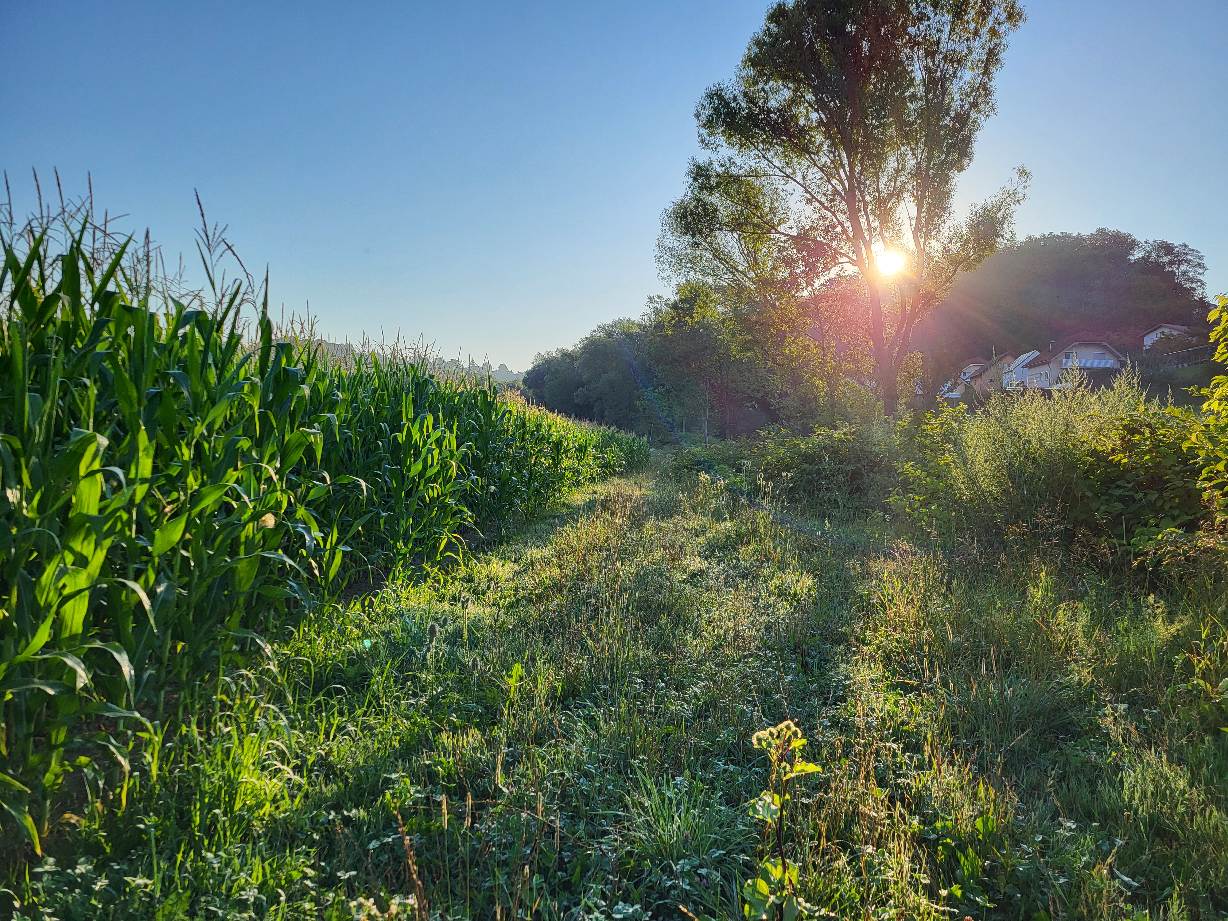
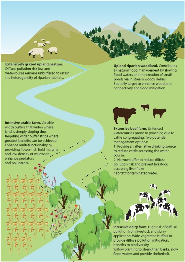
Riparian buffer strips are applied alongside all watercourses and drainage ditches in Slovenia. These buffer zones are legally mandated under the Water Act and GAEC 4 conditionality standards within the EU CAP 2023-2027 framework. Strips, of 3-15 m wide depending on size of the watercourse, serve as transition zones between cultivated fields and waterways, mitigating the impact of agriculture on aquatic ecosystems and surrounding environments.
Strips must comprise grasses, clover, alfalfa, native shrubs, and/or trees. The use of mineral and organic fertilizers is banned, as are pesticides and herbicides. Deep ploughing is prohibited, but surface tillage is allowed for maintenance and sowing (especially if the buffer strip is classified as agricultural land). Grazing is permitted, but with specific restrictions. If the farmer does not maintain the buffer strip, the area is excluded from the system of agricultural land in use and becomes ineligible for any subsidies.
The main purpose of riparian buffer strips is to protect and improve water quality, prevent soil erosion, and support biodiversity. By intercepting surface runoff, they reduce nitrogen, phosphorus, and pesticide contamination from agricultural land. The dense vegetation stabilizes riverbanks. The strips also enhance habitat connectivity for wildlife, providing nesting sites and food sources. Additionally, they play a role in flood mitigation by reducing the speed of stormwater runoff and thus improving water infiltration and retention.
To establish and maintain riparian buffer strips, an initial assessment of existing vegetation and soil determines whether additional planting is needed. If the area lacks sufficient vegetation, direct seeding with suitable species is carried out. Maintenance usually involves mowing, mulching, and occasional pruning. Pruning refers to the removal of overgrown trees and shrubs along the riverbank to prevent spreading onto agricultural land. This work typically requires tools such as a chainsaw and a tractor with a trailer for removing the cut woody material. Farmers must also comply with monitoring and reporting requirements under CAP regulations.
The benefits of riparian buffer strips are primarily environmental. By filtering pollutants before they enter watercourses, they contribute to cleaner water, reduced eutrophication, and improved aquatic ecosystems. They help maintain land productivity in the long term, reducing the need for costly interventions such as dredging or erosion control measures. The vegetation within the strips absorbs carbon, contributing to climate mitigation efforts. Additionally, by complying with regulations, farmers gain access to CAP subsidies and other environmental incentives, making implementation more financially viable.
Despite these advantages, land users have mixed opinions about such strips. Some farmers appreciate the additional forage production, and others find that the buffer zones serve as useful access paths around their fields, making machinery operation easier. However, many landowners dislike the loss of productive farmland, particularly those near first-order watercourses, where wider buffer strips are required. The loss of cultivated land can result in lower crop yields and income reductions, with farms experiencing up to a 6.2% decrease in arable land and financial losses estimated at 7,448 € per farm annually (Lešnik et al. 2024). Some farmers express concerns about the complexity of legal requirements and the costs associated with compliance and maintenance.
While riparian buffer strips are essential for environmental sustainability, their impact on farm economics must be carefully considered. Future strategies may involve flexible width requirements or integration with agroforestry systems to maximize their benefits while minimizing financial burdens.
2.3 صور التقنية
معرض الوسائط
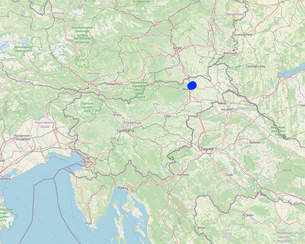
2.5 البلد/المنطقة/المواقع التي تم تنفيذ التقنية فيها والتي يغطيها هذا التقييم
البلد:
سلوفينيا
المنطقة/الولاية/المحافظة:
Jareninski dol, Pernica
مزيد من التفاصيل حول الموقع:
Vosek
حدد انتشار التقنية:
- منتشرة بالتساوي على مساحة
إذا كانت التقنيةا موزعة بالتساوي على منطقة ما، حدد المساحة المغطاة (بالكيلومتر المربع):
137,0
إذا كانت المساحة الدقيقة غير معروفة، فيرجى الإشارة إلى المنطقة التقريبية المغطاة:
- < 0.1 كم2 (10 هكتار)
هل يقع موقع/مواقع التقنية في منطقة محمية بشكل دائم؟:
كلا
Map
×2.6 تاريخ التنفيذ
في حالة عدم معرفة السنة بالتحديد، يرجى الإشارة إلى التاريخ التقريبي:
- منذ أقل من 10 سنوات (مؤخرًا)
2.7 إدخال التقنية
- due to the legislative requirements of agricultural and water policy.
3. تصنيف تقنية الإدارة المستدامي للأراضي
3.1 الغرض الرئيسي ( الأغراض الرئيسية) للتقنية
- الحد من تدهور الأراضي ومنعه وعكسه
- الحفاظ على النظام البيئي
- حماية مستجمعات المياه / المناطق الواقعة في اتجاه مجرى النهر - مع تقنيات أخرى
- الحفاظ على/تحسين التنوع البيولوجي
3.2 نوع (أنواع) استخدام الأراضي الحالية حيث يتم تطبيق التقنية
استخدامات الأراضي مختلطة ضمن نفس وحدة الأرض:
كلا

الأراضي الزراعية
- زراعة سنوية
- زراعة معمرة (غير خشبية)
الزراعة السنوية - حدد المحاصيل:
- محاصيل الأعلاف - البرسيم (الفصة)
- محاصيل الأعلاف - النفل
- محاصيل الأعلاف - الأعشاب
الزراعات المعمرة (غير الخشبية) - حدد المحاصيل:
- محاصيل الأعلاف - الأعشاب
- محاصيل الأعلاف - البقوليات، النفل
عدد مواسم الزراعة في السنة:
- 1
هل يتم ممارسة الزراعة البينية؟:
نعم
إذا كانت الإجابة بنعم، حدد المحاصيل التي يتم زراعتها بشكل بيني:
A mix of grasses, clovers, and alfalfa.
هل تتم ممارسة تناوب المحاصيل؟:
كلا
التعليقات:
The area is generally classified as agricultural land but functions as a buffer zone along water bodies. Fodder crops are typically grown and either harvested for feed or mulched. In some cases, the area may be used for grazing livestock, although this is relatively rare.
3.3 هل تغير استخدام الأراضي نتيجة لتنفيذ التقنية؟
هل تغير استخدام الأراضي نتيجة لتنفيذ التقنية؟:
- نعم (يرجى ملء الأسئلة أدناه فيما يتعلق باستخدام الأراضي قبل تنفيذ التقنية)
استخدامات الأراضي مختلطة ضمن نفس وحدة الأرض:
كلا
الأراضي الزراعية
- زراعة سنوية
الزراعة السنوية - حدد المحاصيل:
- الحبوب - الشعير
- الحبوب - الذرة
- الحبوب - قمح (شتوي)
هل يتم ممارسة الزراعة البينية؟:
كلا
هل تتم ممارسة تناوب المحاصيل؟:
نعم
إذا كانت الإجابة بنعم، حدد:
General crop rotation is practiced, typically alternating between cereals and maize.
3.4 إمدادات المياه
إمدادات المياه للأرض التي يتم تنفيذ التقنية عليها:
- بعلية
3.5 مجموعةالإدارة المستدامة للأراضي التي تنتمي إليها هذه التقنية
- تحسين الغطاء الأرضي/النباتي
- إدارة المياه السطحية (الينابيع، الأنهار، البحيرات، البحار)
- حماية/ إدارة الأراضي الرطبة
3.6 التدابير التقنية في مجال إلادارة المستدامة للأراضي

التدابير النباتية
- V1: غطاء من الأشجار والشجيرات
- V2: الأعشاب والنباتات العشبية المعمرة
- V5: أخرى
التعليقات:
It is considered a vegetative measure because it relies primarily on the establishment and management of permanent vegetation such as grasses, legumes (e.g., clover, alfalfa), shrubs, and trees.
3.7 الأنواع الرئيسية من تدهور الأراضي التي تناولتها التقنية

تآكل التربة بالمياه
- الوزن(Wt): فقدان التربة السطحية/تآكل السطح
- (Wr):انجراف ضفة النهر
- (Wo:) تأثيرات التدهور من مواقع أخرى

التدهور الكيميائي للتربة
- (Cn): تراجع الخصوبة وانخفاض محتوى المادة العضوية (غير ناتج عن الانجراف)

التدهور البيولوجي
- (Bc): تناقص الغطاء النباتي
- (Bh): فقدان الموائل
- (Bs): انخفاض جودة وتركيبة الأنواع/التنوع

تدهور المياه
- (Hw): تناقص القدرة التخفيفية للمناطق الرطبة
3.8 منع أو حد أو عكس تدهور الأراضي
تحديد هدف التقنية فيما يتعلق بتدهور الأراضي:
- منع تدهور الأراضي
- الحد من تدهور الأراضي
4. المواصفات الفنية، وأنشطة التنفيذ، والمدخلات، والتكاليف
4.1 الرسم الفني للتقنية
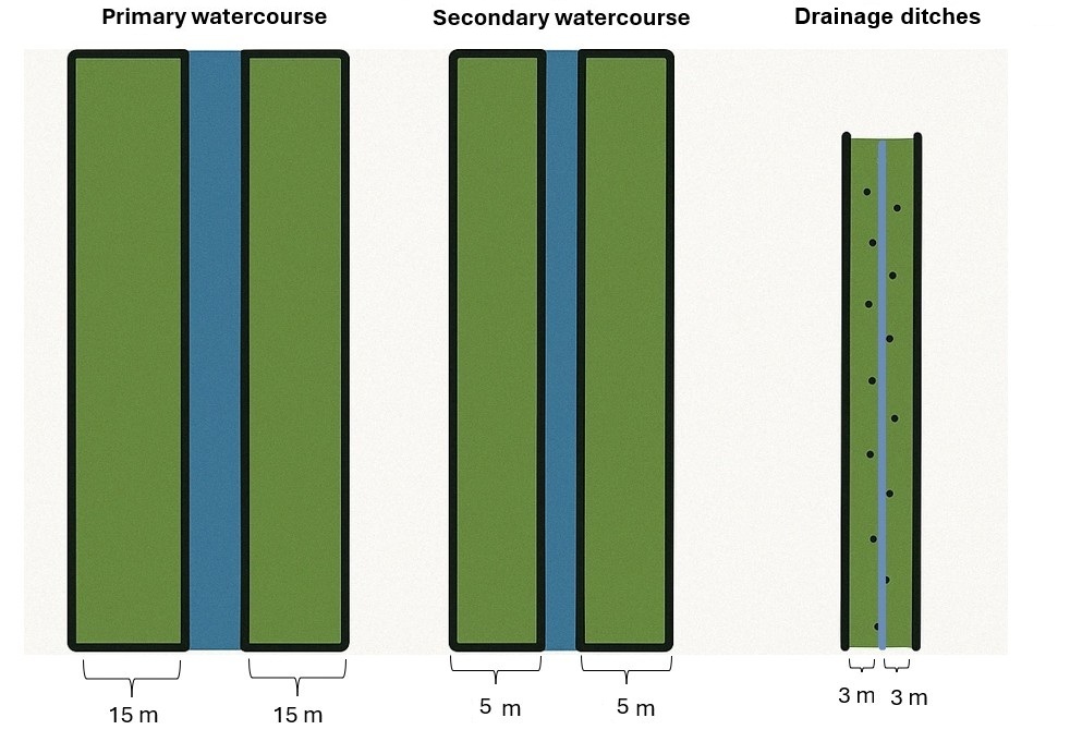
المواصفات الفنية (المتعلقة بالرسم الفني):
Riparian buffer strips are protected zones established along watercourses to reduce agricultural impacts on soil and water quality. These strips remain part of the agricultural land base and may be managed as grassland, limited arable land, or grazing areas. However, to maintain their protective function, specific agricultural inputs and activities are restricted within these areas. If the buffer strips are not properly maintained, they are excluded from the system of agricultural land in use and become ineligible for any subsidies.
Management and Activity Restrictions (applicable to buffer strips only):
Soil tillage: Deep ploughing is prohibited; only shallow (low) tillage is permitted for maintenance and sowing.
Buffer widths (according to the Water Act):
- 15 m along primary watercourses
- 5 m along secondary watercourses
- 3 m along drainage ditches
Vegetation allowed: Grass, grass-clover mixtures, clover-grass mixtures, alfalfa, clover, native shrubs, and trees.
Fertilization: Application of mineral and organic fertilizers is prohibited. Storage or disposal of manure is not allowed. Natural manure from grazing animals is tolerated.
Plant protection products: The use of pesticides has been prohibited in buffer strips since 2002.
Livestock grazing: Grazing is allowed but must not damage the structure of the water body. Animals may drink from the watercourse at designated points, but supplementary feeding is not permitted within the strip.
المؤلف:
Gregor Kramberger
التاريخ:
18/04/2025
المؤلف:
Lorna J. Cole, Jenni Stockan, Rachel Helliwell
التاريخ:
01/07/2020
4.2 معلومات عامة بخصوص حساب المدخلات والتكاليف
حدد كيفية احتساب التكاليف والمدخلات:
- حسب مساحة تنفيذ التقنية
الإشارة إلى حجم ووحدة المساحة:
31,2 hectares
عملة أخرى/ عملة وطنية (حدد):
EUR
إذا كان ذا صلة، وضح سعر الصرف من الدولار الأمريكي إلى العملة المحلية (على سبيل المثال، 1 دولار أمريكي = 79.9 ريال برازيلي): 1 دولار أمريكي =:
0,87
اذكر متوسط تكلفة أجر العمالة المستأجرة في اليوم الواحد:
114
4.3 أنشطة التأسيس
| النشاط | التوقيت (الموسم) | |
|---|---|---|
| 1. | Purchase grass seed mixture | 1st year |
| 2. | Pre-sowing preparation and sowing | 1st year |
التعليقات:
Select grass species or mixtures adapted to local soil and climatic conditions. Minimal soil disturbance recommended; shallow cultivation to ensure proper seed-soil contact.
4.4 التكاليف والمدخلات اللازمة للتأسيس
| تحديد المدخلات | الوحدة | الكمية | التكاليف لكل وحدة | إجمالي التكاليف لكل مدخل | % من التكاليف التي يتحملها مستخدمو الأراضي | |
|---|---|---|---|---|---|---|
| العمالة | Own labor | hour | 3,0 | 9,0 | 27,0 | 100,0 |
| العمالة | Pre-sowing preparation and sowing | hour | 3,0 | 35,0 | 105,0 | 100,0 |
| المواد النباتية | Grass seed mixture | kg/ha | 16,412 | 5,6 | 91,91 | 100,0 |
| إجمالي تكاليف إنشاء التقنية | 223,91 | |||||
| إجمالي تكاليف إنشاء التقنية بالدولار الأمريكي | 257,37 | |||||
التعليقات:
Labor and pre-sowing preparation and sowing also include travel time between sites. The total size of the farm is 31,2 hectares. An area of 4103 m² falls under the restricted buffer strip zone at his farm.
4.5 الصيانة/الأنشطة المتكررة
| النشاط | التوقيت/الوتيرة | |
|---|---|---|
| 1. | Mulching/mowing | 2 times per year |
| 2. | Pruning and clearing of overgrowth | 1 time, winter time |
التعليقات:
4103 m² of agricultural land represents the buffer strips that the farmer actively manages and maintains. Pruning or cutting of woody vegetation, such as trees or shrubs, when they begin to encroach on agricultural land near the riverbank. Farmers typically carry out this work in winter, but it is difficult to estimate the cost, as it can vary significantly depending on the extent of overgrowth.
4.6 التكاليف والمدخلات اللازمة للصيانة/للأنشطة المتكررة (سنويًا)
| تحديد المدخلات | الوحدة | الكمية | التكاليف لكل وحدة | إجمالي التكاليف لكل مدخل | % من التكاليف التي يتحملها مستخدمو الأراضي | |
|---|---|---|---|---|---|---|
| العمالة | Mulching/mowing | hours | 6,0 | 32,0 | 192,0 | 100,0 |
| العمالة | Pruning and clearing of overgrowth | hours | 4,0 | 4,5 | 18,0 | 100,0 |
| العمالة | Own labor | hours | 10,0 | 9,0 | 90,0 | 100,0 |
| إجمالي تكاليف صيانة التقنية | 300,0 | |||||
| إجمالي تكاليف صيانة التقنية بالدولار الأمريكي | 344,83 | |||||
التعليقات:
Opportunity costs were calculated based on the loss of arable land due to the establishment of buffer zones in 2024 on Farm Ropic (total farm size: 32,2 ha, of which 28,6 ha is arable land). The planned crop rotation for that year included wheat, oil pumpkins, barley, and maize. The income foregone represents the estimated revenue that could have been generated from these crops on the area now designated as buffer strips (a total of 4103 m² of arable land).
The estimated income losses by crop type are:
Winter wheat: 113.52 €
Oil pumpkin: 396.80 €
Winter barley: 120.60 €
Grain maize: 68.04 €.
4.7 أهم العوامل المؤثرة على التكاليف
قدم وصفا لأهم العوامل التي تؤثر على التكاليف:
Exact costs are difficult to estimate as they depend heavily on the specific location. If regular maintenance, such as mulching/mowing, is carried out, annual costs remain low, and pruning and clearing of overgrowth work is likely unnecessary. Costs are calculated for farm Ropič.
5. البيئة الطبيعية والبشرية
5.1 المناخ
هطول الأمطار السنوي
- < 250 مم
- 251- 500 ملم
- 501 - 750ملم
- 1,000-751 ملم
- 1,500-1,100 ملم
- 2,000-1,500 ملم
- 3,000-2,001 ملم
- 4,000-3,100 ملم
- > 4000 ملم
حدد متوسط هطول الأمطار السنوي (إذا كان معروفًا)، بالملليمتر:
1032,00
المواصفات/التعليقات على هطول الأمطار:
The most precipitation falls in summer, the months with the highest average precipitation are August and September, the least precipitation falls in winter, in January and February at least, and in principle more precipitation falls in autumn than in spring.
الإشارة إلى اسم محطة الأرصاد الجوية المرجعية المعنية:
Jareninski Vrh (1991-2020)
المنطقة المناخية الزراعية
- شبه رطبة
The average annual air temperature at Jareninski Vrh during the reference period 1991–2020 was 10.1 °C.
5.2 طوبوغرافيا
متوسط الانحدارات:
- مسطح (0-2%)
- بسيط (3-5%)
- معتدل (6-10%)
- متدحرج (11-15%)
- تلال (16-30%)
- شديدة الانحدار(31-60%)
- فائقة الانحدار (>60%)
التضاريس:
- هضاب/سهول
- أثلام مرتفعة
- المنحدرات الجبلية
- منحدرات التلال
- منحدرات في السفوح
- قاع الوادي
المنطقة الارتفاعية:
- 100-0 متر فوق سطح البحر
- 500-101 متر فوق سطح البحر
- 1,000-501 متر فوق سطح البحر
- 1,500-1,001 متر فوق سطح البحر
- 2,000-1,501 متر فوق سطح البحر
- 2,500-2,100 متر فوق سطح البحر
- 3,000-2,501 متر فوق سطح البحر
- 4,000-3,001 متر فوق سطح البحر
- > 4000 متر فوق سطح البحر
وضح ما إذا كانت التقنية مطبقة على وجه التحديد في:
- حالات مقعرة
التعليقات والمواصفات الإضافية بشأن التضاريس:
There are depressions, settlements are in the valley, concave type.
5.3 التربة
متوسط عمق التربة:
- ضحل جدًا (0-20 سم)
- ضحلة (21-50 سم)
- متوسطة العمق (51-80 سم)
- عميقة (81-120 سم)
- عميقة جدًا (> 120 سم)
قوام التربة (التربة السطحية):
- متوسط ( طميي، سلتي)
قوام التربة (> 20 سم تحت السطح):
- متوسط ( طميي، سلتي)
المواد العضوية في التربة السطحية:
- عالية (>3%)
5.4 توافر المياه ونوعيتها
منسوب المياه الجوفية:
50-5 م
توافر المياه السطحية:
جيد
نوعية المياه (غير المعالجة):
للاستخدام الزراعي فقط (الري)
تشير جودة المياه إلى:
المياه السطحية
هل تعتبر ملوحة الماء مشكلة؟:
كلا
هل تحدث فيضانات في المنطقة؟:
نعم
الإنتظام:
بشكل عرضي
تعليقات ومواصفات أخرى بشأن نوعية المياه وكميتها:
Hydromelioration was carried out in the area, a drainage system and water retention systems (e.g. ponds and basins) were arranged.
5.5 التنوع البيولوجي
تنوع الأنواع:
- متوسط
تنوع الموائل:
- متوسط
5.6 خصائص مستخدمي الأراضي الذين يطبقون التقنية
مستقر أو مرتحل:
- غير المترحل
التوجه السوقي لنظام الإنتاج:
- تجاري/سوق
الدخل من خارج المزرعة:
- 10-50% من جميع الإيرادات
المستوى النسبي للثروة:
- متوسط
أفراداً أو مجموعات:
- فرد/أسرة معيشية
مستوى المكننة:
- ميكانيكية/ مزودة بمحرك
الجنس:
- رجال
عمر مستخدمي الأرضي:
- متوسط العمر
5.7 متوسط مساحة الأرض التي يستخدمها مستخدمو الأراضي الذين يطبقون التقنية
- < 0.5 هكتارا
- 0.5 - 1 هكتار
- 1 -2 هكتار
- 2 - 5 هكتار
- 5 - 15 هكتار
- 15 - 50 هكتار
- 50 - 100هكتار
- 500-100 هكتار
- 1,000-500 هكتار
- 10,000-1,000 هكتار
- > 10,000 هكتار
هل يعتبر هذا نطاقًا صغيرًا أو متوسطًا أو واسعا (في إشارة إلى السياق المحلي)؟:
- على نطاق متوسط
5.8 ملكية الأراضي، وحقوق استخدام الأراضي، وحقوق استخدام المياه
ملكية الارض:
- فردية، يوجد سند ملكية
حقوق استخدام الأراضي:
- مؤجر
- فردي
حقوق استخدام المياه:
- مجتمعي (منظم)
حدد:
Based on national legal system.
5.9 الوصول إلى الخدمات والبنية التحتية
الصحة:
- ضعيف
- معتدل
- جيد
التعليم:
- ضعيف
- معتدل
- جيد
المساعدة التقنية:
- ضعيف
- معتدل
- جيد
العمل (على سبيل المثال خارج المزرعة):
- ضعيف
- معتدل
- جيد
الأسواق:
- ضعيف
- معتدل
- جيد
الطاقة:
- ضعيف
- معتدل
- جيد
الطرق والنقل:
- ضعيف
- معتدل
- جيد
مياه الشرب وخدمات الصرف الصحي:
- ضعيف
- معتدل
- جيد
الخدمات المالية:
- ضعيف
- معتدل
- جيد
6. الآثار والتصريحات الختامية
6.1 الآثار التي أظهرتها التقنية في الموقع
الآثار الاجتماعية والاقتصادية
الإنتاج
إنتاج المحاصيل
التعليقات/ حدد:
The loss of productive farmland depends on the width of buffer strips and the total farm size. Impact on yield varies depending on the previous land use (e.g., maize, wheat, barley were replaced by permanent vegetation).
إنتاج الأعلاف
التعليقات/ حدد:
Some farmers report that grasses grown in riparian buffer strips can be harvested for hay or grazed by livestock, partially compensating for lost crop land. Dairy or mixed farms benefit more from fodder production.
منطقة الإنتاج
التعليقات/ حدد:
The implementation of riparian buffer strips directly reduces the production area, as these zones must be permanently maintained with grass, shrubs, or trees instead of crops.
إدارة الأراضي
التعليقات/ حدد:
Less flexibility in field layout and crop management (without plowing, fertilization, or pesticides). Additional maintenance like mulching and active cultivation area is reduced. Buffer strips create machinery access/driving zones and reduce erosion.
توافر المياه ونوعيتها
نوعية مياه الشرب
التعليقات/ حدد:
They filter agricultural runoff and prevent fertilizers, pesticides and sediments from entering waterways. They reduce nitrate leaching and chemical pollution, improving the quality of groundwater and surface water.
نوعية المياه للماشية
التعليقات/ حدد:
They filter pollutants before they reach streams and water sources, improving water quality for grazing animals.
الدخل والتكاليف
دخل المزرعة
التعليقات/ حدد:
The loss of productive land due to buffer strips reduces crop output, affecting farm revenue.
عبء العمل
التعليقات/ حدد:
Farmers need to mow or mulch buffer strips regularly to prevent overgrowth. Sometimes tree maintenance is necessary.
الآثار الاجتماعية والثقافية
الفرص الترفيهية
التعليقات/ حدد:
Access to water bodies for recreational purposes.
الآثار الايكولوجية
دورة المياه / الجريان السطحي
جودة المياه
التعليقات/ حدد:
They filter out nitrates, phosphorus, pesticides, and sediments before they reach water bodies.
الجريان السطحي
التعليقات/ حدد:
They slow surface runoff, increase water infiltration, and reduce the transport of sediments, fertilizers, and pesticides into water bodies.
التربة
غطاء التربة
التعليقات/ حدد:
They maintaiThey maintain continuous vegetation cover in the zone around the water body.n continuous vegetation cover and reduce soil exposure to erosion.
فقدان التربة
التعليقات/ حدد:
They significantly reduce soil erosion, they stabilize the soil and trap sediment, especially during floods.
التنوع البيولوجي: الغطاء النباتي، الحيوانات
الغطاء النباتي
التعليقات/ حدد:
Permanent vegetation cover in buffer strips, improving soil stability and biodiversity.
التنوع النباتي
التعليقات/ حدد:
Increased diversity of grasses, legumes, shrubs, and trees, creating a more resilient ecosystem.
التنوع الحيواني
التعليقات/ حدد:
Riparian buffer strips provide habitat for birds, insects, amphibians, and small mammals, increasing biodiversity and ecological stability.
الأنواع المفيدة
التعليقات/ حدد:
Increased presence of pollinators, predatory insects, and other beneficial organisms.
تنوع الموائل
التعليقات/ حدد:
With riparian buffer strips we create diverse habitats by introducing a mix of grasses, shrubs, and trees, supporting a wider range of species.
الحد من مخاطر المناخ والكوارث
آثار الفيضانات
التعليقات/ حدد:
Deep-rooted vegetation stabilizes riverbanks, preventing erosion and minimizing damage during high water events.
حدد تقييم الآثار في الموقع (القياسات):
The data provided are not based on direct measurements but are derived from statements by the land user (farmer) and expert judgement from an agricultural adviser. They reflect practical experience and informed estimates rather than measured field data.
6.2 الآثار التي أظهرتها التقنية خارج الموقع
تلوث المياه الجوفية/الأنهار
التعليقات/ حدد:
Due to a significant reduction in the leaching of pollutants, leading to cleaner water sources.
القدرة على التخفيف / الترشيح
التعليقات/ حدد:
Significant reduction in pollutants as buffer strips trap sediments and filter nutrients and chemicals before reaching watercourses.
قيّم الآثار خارج الموقع (القياسات):
The data provided are not based on direct measurements but are derived from statements by the land user (farmer) and expert judgement from an agricultural adviser. They reflect practical experience and informed estimates rather than measured field data.
6.3 تعرض التقنية وحساسيتها لتغير المناخ التدريجي والظواهر المتطرفة/الكوارث المرتبطة بالمناخ (كما يراها مستخدمو الأراضي)
تغير مناخ تدريجي
تغير مناخ تدريجي
| الموسم | زيادة أو نقصان | كيف تتعامل التقنية مع ذلك؟ | |
|---|---|---|---|
| درجة الحرارة السنوية | زيادة | باعتدال | |
| درجة الحرارة الموسمية | الصيف | زيادة | باعتدال |
| درجة الحرارة الموسمية | الربيع | زيادة | باعتدال |
| درجة الحرارة الموسمية | الخريف | زيادة | باعتدال |
| درجة الحرارة الموسمية | الشتاء | زيادة | باعتدال |
| هطول الأمطار الموسمية | الصيف | زيادة | جيدة جدا |
| هطول الأمطار الموسمية | الربيع | زيادة | جيدة جدا |
| هطول الأمطار الموسمية | الخريف | انخفاض | باعتدال |
الظواهر المتطرفة / الكوارث المرتبطة بالمناخ
الكوارث الجوية
| كيف تتعامل التقنية مع ذلك؟ | |
|---|---|
| عاصفة ممطرة محلية | جيدة جدا |
الكوارث المناخية
| كيف تتعامل التقنية مع ذلك؟ | |
|---|---|
| موجة حر | جيدا |
الكوارث الهيدرولوجية
| كيف تتعامل التقنية مع ذلك؟ | |
|---|---|
| فيضان عام (نهر) | جيدة جدا |
| فيضان مفاجئ | جيدة جدا |
6.4 تحليل التكلفة والعائد
كيف يمكن مقارنة العوائد نسبة لتكاليف الإنشاء (من وجهة نظر مستخدمي الأراضي)؟
عوائد قصيرة الأجل:
سلبي قليلا
عوائد طويلة الأجل:
إيجابي قليلا
كيف تتم مقارنة العوائدمع كلفة الصيانة/التكاليف المتكررة (من وجهة نظر مستخدمي الأراضي)؟
عوائد قصيرة الأجل:
محايد/متوازن
عوائد طويلة الأجل:
إيجابي
التعليقات:
Establishment costs are high, including soil preparation, seeding, and potential fencing, while the loss of productive land immediately reduces farm income. Subsidies may offset some costs, but they do not fully compensate for the initial financial impact. In a long-term benefits such as improved soil stability, water quality, and flood protection reduce future expenses. Over time, subsidies, reduced erosion, and potential fodder production help balance the initial investment.
Maintenance costs, such as mowing or mulching and tree maintenance, add labor and equipment expenses, but the absence of fertilizer and pesticide costs helps balance them. Subsidies for maintaining buffer strips further offset these recurrent costs, keeping short-term financial impact neutral. Once vegetation is established, maintenance costs decrease, requiring only occasional mowing or grazing. Over time, benefits like erosion control, improved soil health, and reduced flood damage outweigh the minimal upkeep expenses, making the practice economically sustainable.
6.5 اعتماد التقنية
- > 50%
إذا كان متاحًا، قم بتحديد الكمية (عدد الأسر المعيشية و/أو المساحةالمغطاة):
All farmers in the area must comply with the implementation of riparian buffer strips as part of the GAEC 4 standard under CAP conditionality. This means that all agricultural land users with fields adjacent to watercourses are required to establish and maintain these protective strips, ensuring compliance with national and EU environmental regulations.
من بين جميع الذين تبنوا التقنية، كم عدد الذين فعلوا ذلك بشكل تلقائي، أي دون تلقي أي حوافز مادية/مدفوعات؟:
- 10-0%
6.6 التكيف
هل تم تعديل التقنية مؤخرًا لتتكيف مع الظروف المتغيرة؟:
نعم
أخرى (حدد):
CAP
حدد تكيف التقنية(التصميم، المواد/الأنواع، الخ.):
The requirements for riparian buffer strips have been updated to align with GAEC 4 conditionality and the EU Strategic Plan Regulation. The establishment of buffer strips is now mandatory along first-order watercourses (15 m wide), second-order watercourses (5 m wide), and drainage ditches (3 m wide).
Within these buffer zones, the use of organic and mineral fertilizers, as well as plant protection products (PPPs), is strictly prohibited. Ploughing is not allowed, but shallow tillage is permitted for maintenance (mowing, mulching, or grazing) and for preparing soil for sowing approved crops.
The buffer strips can be covered with grass, grass-legume mixtures, clover, alfalfa, naturally occurring vegetation, shrubs, or trees. Livestock grazing is permitted but must not alter the structure of the riverbank. Animals cannot be supplementary fed within the buffer zones and must be provided drinking water only at designated, controlled locations in small groups to minimize environmental impact.
6.7 نقاط القوة / المزايا / الفرص التي توفرها التقنية
| نقاط القوة/ المزايا/ الفرص من وجهة نظر مستخدمي الأراضي |
|---|
| Buffer strips stabilize soil and prevent erosion. |
| They reduce the impact of flooding on agricultural land. |
| Less leaching of nutrients and plant protection products into water. |
| Additional turning point and driving path for machines. |
| Establishing and maintaining buffer strips can qualify farmers for financial incentives and support programs. |
| Additional shelters for wildlife. |
| نقاط القوة/ المزايا/ الفرص من وجهة نظر جامع المعلومات أو غيره من الاشخاص الرئيسيين لمصدر المعلومات |
|---|
| These buffers effectively filter out nutrients, pesticides, and sediments from agricultural runoff, thereby enhancing the quality of nearby water bodies. |
| By stabilizing stream banks, riparian buffers reduce soil erosion, preserving valuable topsoil and maintaining land productivity. |
| They provide critical habitats for various wildlife species, promoting biodiversity and creating wildlife corridors in agricultural landscapes. |
| Riparian buffer strips contribute to ecosystem services like carbon sequestration and pollination, supporting broader environmental goals. |
6.8 نقاط ضعف / مساوىء / مخاطر التقنية وسبل التغلب عليها
| نقاط الضعف/ المساوىء/ المخاطر من وجهة نظر مستخدم الأراضي | كيف يمكن التغلب عليها؟ |
|---|---|
| The buffer zones are too wide, significantly reducing cultivated land area, which negatively impacts crop yields and farm income. | Increase subsidies and financial incentives for farmers to compensate for the loss of productive land within riparian buffer strips. |
| Maintenance tasks such as mowing, mulching, or controlled grazing require extra labor and resources and establishing buffer strips involves expenses for seeds, machinery, soil preparation, and potential fencing. | Provide additional payments for ongoing maintenance activities or investment support to offset initial establishment costs. |
| The legislation and administrative requirements are complex, involving numerous regulations that farmers find difficult to understand and follow. | Provide more accessible, user-friendly information, along with targeted advisory services and educational programs to help farmers better navigate these rules. |
| نقاط الضعف/ المساوىء/ المخاطر من وجهة نظر جامع المعلومات أو غيره من الاشخاص الرئيسيين لمصدر المعلومات | كيف يمكن التغلب عليها؟ |
|---|---|
| In certain conditions, the redirected flow of water due to buffer strips may weaken streambanks, leading to erosion and land loss. | Designing buffer zones with appropriate vegetation, width and adapted to local conditions, and regularly monitoring the situation. |
| Over time, buffer strips can become saturated with nutrients, reducing their effectiveness and possibly turning them into sources of pollution. | Regular vegetation management, harvesting or removal of biomass to prevent nutrient accumulation. Crop rotation or periodic rejuvenation of buffer zone vegetation to maintain its filtering capacity. |
| Proper upkeep involves tasks like weed control, pruning, replanting, and protection against wildlife, increasing the workload for farmers. | Provide farmers with targeted financial support or subsidies for maintenance tasks, promote low-maintenance vegetation species, and offer technical assistance or training in efficient management practices. |
| Initial setup requires investment in planting, while ongoing maintenance demands additional labor and resources. | Offer financial incentives, subsidies, or cost-sharing programs to cover initial establishment expenses, and provide ongoing support or training to minimize labor and maintenance costs. |
7. المراجع والروابط
7.1 طرق جمع/مصادر المعلومات
- مقابلات مع مستخدمي الأراضي
1 (Andrej Ropič, farmer)
- مقابلات مع المتخصصين/الخبراء في الإدارة المستدامة للأراضي
2 (Chamber of Agriculture and Forestry of Slovenia (KGZS) – Institute of Agriculture and Forestry Maribor; Tamara Korošec and Timotej Horvat)
- التجميع من التقارير والوثائق الأخرى الموجودة
CAP and Slovenian Strategic Plan 2023-2027.
متى تم تجميع البيانات (ميدانيا)؟:
17/01/2023
التعليقات:
Visit to the farm and farmer interview.
7.2 المراجع للمنشورات المتاحة
العنوان، المؤلف، السنة، النظام القياسي الدولي لترقيم الكتب ISBN:
Cole, L. J., Stockan, J., & Helliwell, R. (2020). Managing riparian buffer strips to optimise ecosystem services: A review. Agriculture, Ecosystems & Environment, 296, 106891.
متاح من أين؟كم التكلفة؟:
https://doi.org/10.1016/j.agee.2020.106891
العنوان، المؤلف، السنة، النظام القياسي الدولي لترقيم الكتب ISBN:
Macleod, C. J. A., Haygarth, P. M., et al. (2022). Impacts of different vegetation in riparian buffer strips on runoff and suspended sediment loss. Environmental Research Communications, 4(1), 015001.
متاح من أين؟كم التكلفة؟:
https://doi.org/10.1088/2515-7620/ac3c2b
العنوان، المؤلف، السنة، النظام القياسي الدولي لترقيم الكتب ISBN:
Dlamini, J. C., Cardenas, L. M., Tesfamariam, E. H., Dunn, R. M., Loick, N., Charteris, A. F., Cocciaglia, L., Vangeli, S., Blackwell, M. S. A., Upadhayay, H. R., et al. (2022). Riparian buffer strips influence nitrogen losses as nitrous oxide and leached N from upslope permanent pasture. Agriculture, Ecosystems &
متاح من أين؟كم التكلفة؟:
https://doi.org/10.1016/j.agee.2022.108031
العنوان، المؤلف، السنة، النظام القياسي الدولي لترقيم الكتب ISBN:
Lešnik, T., Bogovič, D., Pokupec, D., & Borec, A. (2024). The impact of riparian zones along rivers under the new CAP in Slovenia. Journal of Central European Agriculture, 25(4), 1185–1192.
متاح من أين؟كم التكلفة؟:
https://doi.org/10.5513/JCEA01/25.4.4348
7.3 روابط للمعلومات ذات الصلة على الإنترنت
العنوان/الوصف:
Ministry of Agriculture, Forestry and Food. (2024). Unified Application 2024: Guidelines for the implementation of interventions under the Strategic Plan of the Common Agricultural Policy 2023–2027. Ljubljana, Slovenia.
عنوان الرابط URL:
https://www.kgzs.si/uploads/eiv24/NAVODILA%201/00_VELIKA_NAVODILA_2024_-_CELOTA_-_28_5_24.pdf
الروابط والوحدات المواضيعية
توسيع الكل طي الكلالروابط
لا يوجد روابط
الوحدات المواضيعية
لا يوجد وحدات مواضيعية