Monitoring and Management of Agroforestry using SmartAG [البرتغال]
- تاريخ الإنشاء:
- تحديث:
- جامع المعلومات: Patrícia Lourenço
- المحرر: –
- المراجعون: Joana Eichenberger, William Critchley, Rima Mekdaschi Studer
Agroforestry in Montado and Dehesa
technologies_7126 - البرتغال
عرض الأقسام
توسيع الكل طي الكل1. معلومات عامة
1.2 تفاصيل الاتصال بالأشخاص الرئيسيين لمصدر المعلومات والمؤسسات المشاركة في تقييم وتوثيق التقنية
الشخص (الأشخاص) الرئيسي لمصدر المعلومات
متخصص في الإدارة المستدامة للأراضي:
Lourenço Patrícia
AgroInsider
البرتغال
متخصص في الإدارة المستدامة للأراضي:
Marques da Silva José Rafael
AgroInsider
البرتغال
متخصص في الإدارة المستدامة للأراضي:
Paixão Luís
AgroInsider
البرتغال
اسم المشروع الذي سهّل توثيق/تقييم التقنية (إذا كان ذلك على صلة)
Land Use Based Mitigation for Resilient Climate Pathways (LANDMARC)1.3 الشروط المتعلقة باستخدام البيانات الموثقة من خلال WOCAT
يوافق جامع المعلومات والشخص (لاشخاص) الرئيسي لمصدر المعلومات على الشروط المتعلقة باستخدام البيانات الموثقة من خلال WOCAT:
نعم
1.4 إعلان بشأن استدامة التقنية الموصوفة
هل التقنية الموصوفة هنا تمثل مشكلة فيما يتعلق بتدهور الأراضي، بحيث لا يمكن إعلانها تقنية مستدامة لإدارة الأراضي؟:
كلا
2. وصف تقنيةالإدارة المستدامي للأراضي
2.1 وصف مختصر للتقنية
تعريف التقنية:
The Montado/ Dehesa Agroforestry system contributes to carbon sequestration in Spain and Portugal. The SmartAG app helps in monitoring and management of these systems, providing data available to farmers, producers, and stakeholders.
2.2 وصف تفصيلي للتقنية
الوصف:
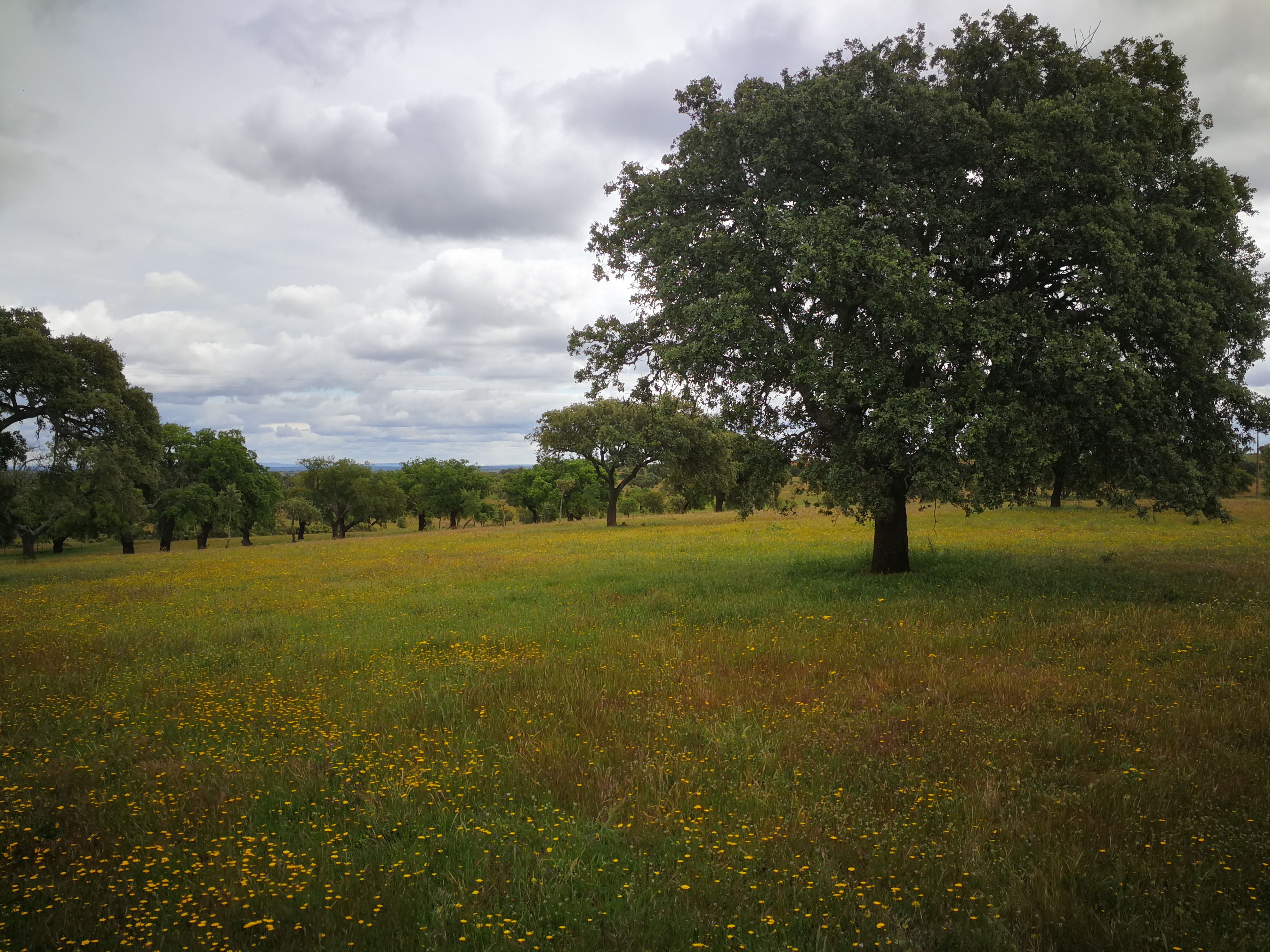
The SmartAG model is mainly applied in the Montado (Portugal) and Dehesa (Spain) agroforestry systems which serve as a biodiversity oasis in the
Mediterranean region. They are currently being heavily impacted by climate change.
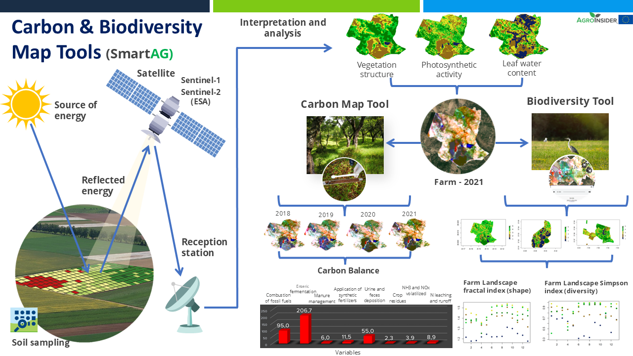
It contributes to achieving carbon sequestration potential. The SmartAG model is also applied in agriculture systems in Portugal, Spain, Greece, The Netherlands, Indonesia and Ukraine. Nevertheless, it can be applied in any part of the world. The SmartAG app provides accurate Agricultural Climate Services on a large-scale, available to farmers, producers, and stakeholders. The model analyzes agronomic anomalies to reduce CO2 emissions and promote CO2 sequestration in the soil, via remote sensing. Additionally, it seeks to remotely analyze farms by evaluating the spatiotemporal dynamics occurring in agroforestry activities for the same purposes.
Through data collection on land use, mapping, remote sensing and in situ data collection, an assessment of the initial state of the farm is carried out, along a carbon balance, to establish a reference scenario (baseline year). Future projections are made, and recommendations formulated.
Users appreciate this methodology because it helps them conserve or increase current carbon stocks, potentially creating a new source of income through the sale
of carbon credits. SmartAG is a highly user-friendly app which records georeferenced evidence of existing conditions and activities. It facilitates a transparent and participatory process in agroforestry ecosystem management.
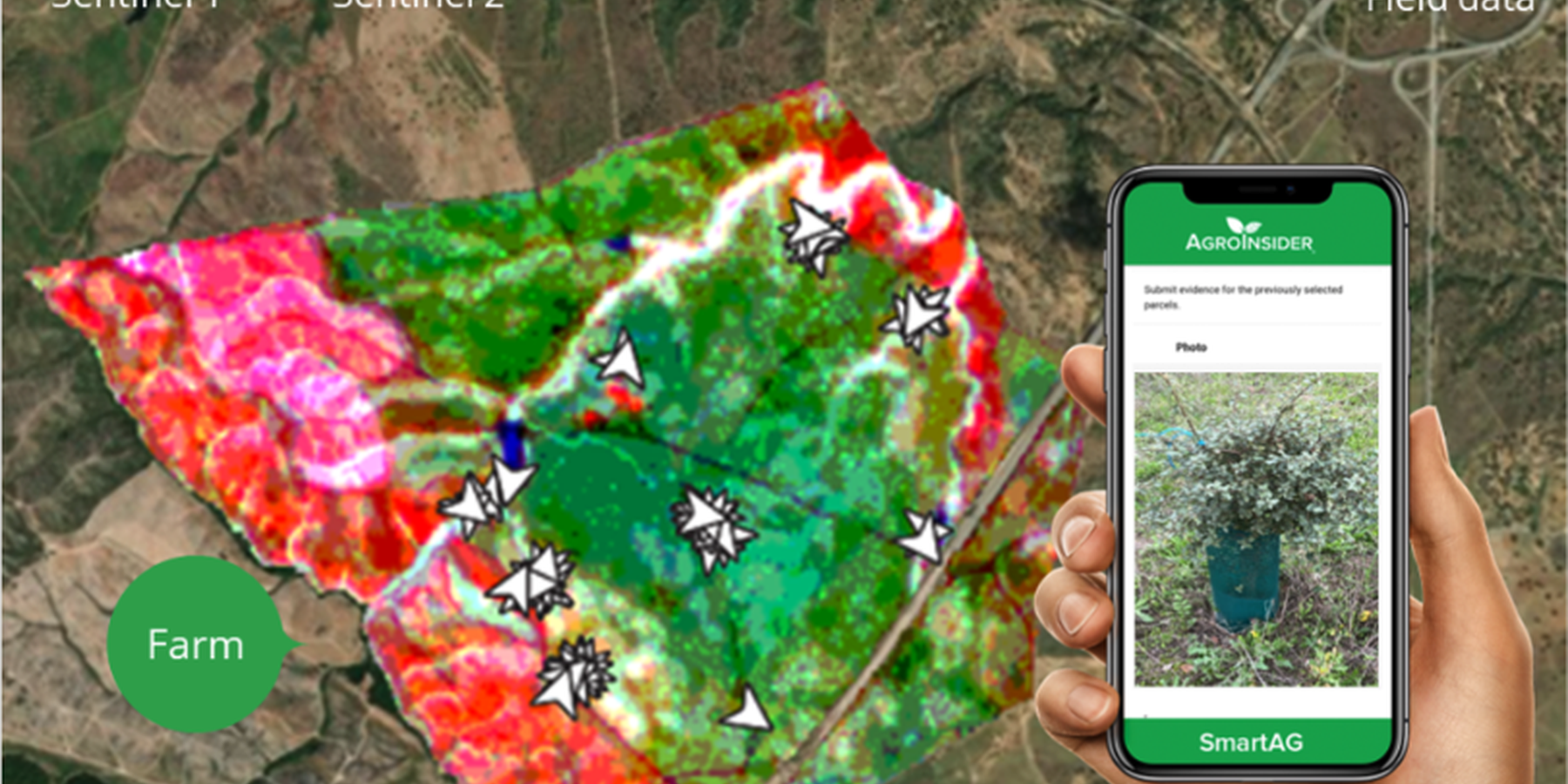
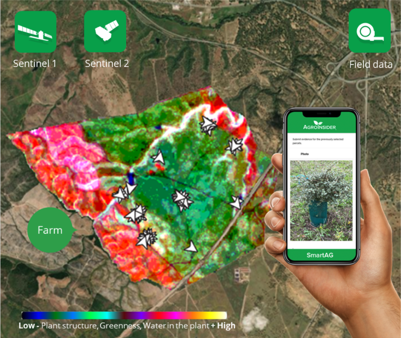
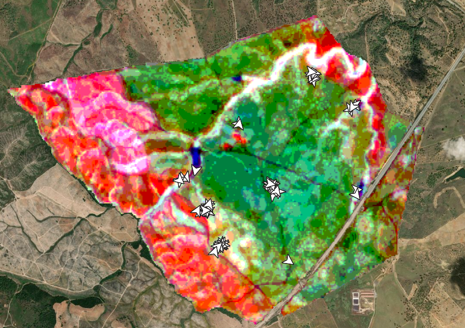
SmartAG automatically processes data from Sentinel-1 and Sentinel-2 data, and LST data for thermo-climatic zoning. These data: i) allow monitoring, reporting and verification of farms; ii) provide machine learning capabilities in agroforestry and environmental data.
Based on Sentinel data, spectral vegetation indices are calculated to identify: i) crop anomalies related to soil-water-plant; ii) management zones to define different land uses, the selection of sampling locations and sensor installation sites, water sampling locations, and identification of species for biodiversity quantification.
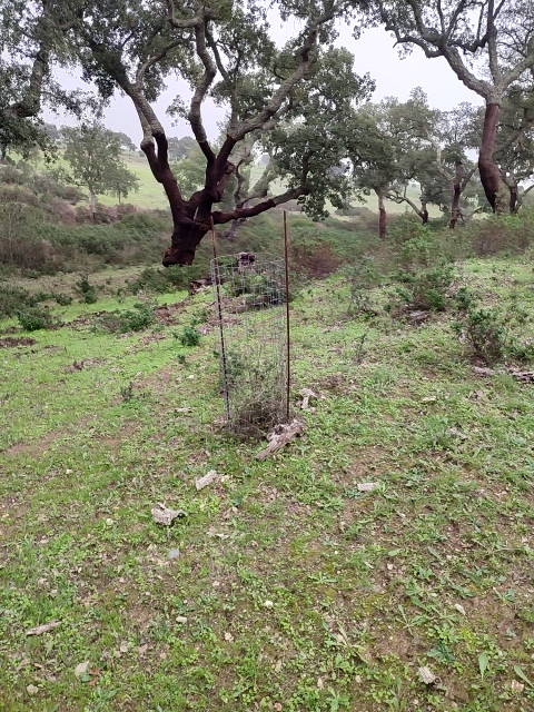
The Montado/Dehesa is a slow-developing and very complex agroforestry system meaning that differences will be observable only at the end of a year or longer. In addition, it is a highly stratified system, consisting of a complex arboreal structure with trees of different ages, shrubs, and herbaceous vegetation. Given the limitations of Sentinel-1 and Sentinel-2 satellites it is essential to record georeferenced evidence of these. Using SmartAG app developed by AgroInsider allows the collection of georeferenced evidence (e.g., photos, audios, and videos) of
the vegetation structures, as well as documenting evidence of processes occurring such as ecosystem services and biodiversity. Georeferenced evidence is automatically uploaded into the system.
2.3 صور التقنية
معرض الوسائط
2.4 فيديوهات عن التقنية
تعليقات، وصف موجز:
https://www.youtube.com/watch?v=zxKjnAAkSI0
التاريخ:
16/06/2023
الموقع:
Évora, Portugal
اسم مصور الفيديو:
Filipa Santos
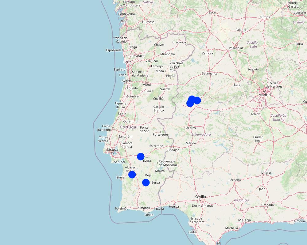
2.5 البلد/المنطقة/المواقع التي تم تنفيذ التقنية فيها والتي يغطيها هذا التقييم
البلد:
البرتغال
المنطقة/الولاية/المحافظة:
Alentejo
حدد انتشار التقنية:
- منتشرة بالتساوي على مساحة
إذا كانت التقنيةا موزعة بالتساوي على منطقة ما، حدد المساحة المغطاة (بالكيلومتر المربع):
100000,0
هل يقع موقع/مواقع التقنية في منطقة محمية بشكل دائم؟:
نعم
إذا كانت الإجابة بنعم، حدد:
Montado and Dehesa constitute a Very High Nature Value agroforestry system which is under protection.
Map
×2.6 تاريخ التنفيذ
اذكر سنة التنفيذ:
2023
2.7 إدخال التقنية
حدد كيف تم إدخال التقنية:
- أثناء التجارب/الأبحاث
التعليقات (نوع المشروع، الخ):
In 2023 AgroInsider started the implementation of the LMT and SmartAG monitoring in Agroforestry system case studies in Montado, in Portugal, and Dehesa, in Spain.
3. تصنيف تقنية الإدارة المستدامي للأراضي
3.1 الغرض الرئيسي ( الأغراض الرئيسية) للتقنية
- الحد من تدهور الأراضي ومنعه وعكسه
- الحفاظ على النظام البيئي
- حماية مستجمعات المياه / المناطق الواقعة في اتجاه مجرى النهر - مع تقنيات أخرى
- الحفاظ على/تحسين التنوع البيولوجي
- التخفيف من تغير المناخ وآثاره
3.2 نوع (أنواع) استخدام الأراضي الحالية حيث يتم تطبيق التقنية
استخدامات الأراضي مختلطة ضمن نفس وحدة الأرض:
نعم
حدد استخدام الأراضي المختلطة (المحاصيل / الرعي / الأشجار):
- الرعي الزراعي الحرجي

أراضي الرعي
الرعي الواسع النطاق:
- مربى ماشية محدد
- الترحال الرعوي
الرعي المكثف/ إنتاج الأعلاف:
- مراعي محسنة
نوع الحيوان:
- الماشية -لإنتاج اللحوم وليس للألبان
- الدواجن
- الأغنام
هل يتم تطبيق الإدارة المتكاملة للمحاصيل والثروة الحيوانية؟:
كلا
المنتجات والخدمات:
- اللحوم
- الحليب
- الصوف
الصنف:
الأغنام
العدد:
40
الصنف:
الماشية - لإنتاج الألبان واللحوم (على سبيل المثال الزيبو)
العدد:
40

الغابات/ الأراضي الحرجية
- الغابات/الأراضي الحرجية (شبه) الطبيعية
الغابات/الأراضي الحرجية (شبه) الطبيعية: حدد نوع الإدارة:
- إزالة الخشب الميت/مخلفات التقليم
- Mediterranean Agroforestry System (Montado/Dehesa)
- cork holm, cork oak
هل الأشجار المذكورة أعلاه ملحاء أم دائمة الخضرة؟:
- دائمة الخضرة
منتجات وخدمات:
- الفواكه والمكسرات
- حفظ/حماية الطبيعة
- cork
3.3 هل تغير استخدام الأراضي نتيجة لتنفيذ التقنية؟
هل تغير استخدام الأراضي نتيجة لتنفيذ التقنية؟:
- لا (تابع مع السؤال 3.4)
3.4 إمدادات المياه
إمدادات المياه للأرض التي يتم تنفيذ التقنية عليها:
- بعلية
3.5 مجموعةالإدارة المستدامة للأراضي التي تنتمي إليها هذه التقنية
- الحراجة الزراعية
- الرعي وإدارة المراعي
- تحسين الغطاء الأرضي/النباتي
3.6 التدابير التقنية في مجال إلادارة المستدامة للأراضي

التدابير النباتية
- V1: غطاء من الأشجار والشجيرات
- V2: الأعشاب والنباتات العشبية المعمرة

التدابير الإدارية
- M1: التغيير في نوع استخدام الأراضي
- M2: تغيير في مستوى الإدارة/الكثافة
3.7 الأنواع الرئيسية من تدهور الأراضي التي تناولتها التقنية

التدهور الكيميائي للتربة
- (Cn): تراجع الخصوبة وانخفاض محتوى المادة العضوية (غير ناتج عن الانجراف)
- (Ca):التحمض

التدهور المادي أو الفيزيائي للتربة
- (Pc) : تراص التربة
3.8 منع أو حد أو عكس تدهور الأراضي
تحديد هدف التقنية فيما يتعلق بتدهور الأراضي:
- منع تدهور الأراضي
- الحد من تدهور الأراضي
4. المواصفات الفنية، وأنشطة التنفيذ، والمدخلات، والتكاليف
4.1 الرسم الفني للتقنية
المواصفات الفنية (المتعلقة بالرسم الفني):
The LMT will be implemented on a farm with montado/dehesa (minimum area of 100 ha). Satellite data is used to characterize land use. After identifying the montado/dehesa area, field sampling is conducted. These data, along with satellite imagery, will be used to calculate the total CO2eq stock (above and below ground biomass) and estimate CO2eq sequestration. Farmers are encouraged to enhance LMT effectiveness, notably by engaging in ecosystem-value activities such as avoiding soil disturbance to preserve soil organic matter, increasing tree density, and maintaining water mirrors. Farmers will record georeferenced evidence of improvement activities and existing biodiversity in the montado and in other areas of the farm using the SmartAG developed by AgroInsider. This app will allow to monitor, report and verify carbon stocks through weekly alert reports, enabling the identification of carbon anomalies/losses over time and space.
المؤلف:
Patrícia Lourenço
التاريخ:
23/04/2024
4.2 معلومات عامة بخصوص حساب المدخلات والتكاليف
حدد كيفية احتساب التكاليف والمدخلات:
- حسب مساحة تنفيذ التقنية
الإشارة إلى حجم ووحدة المساحة:
100 ha
عملة أخرى/ عملة وطنية (حدد):
Euro (€)
اذكر متوسط تكلفة أجر العمالة المستأجرة في اليوم الواحد:
3590 €
4.3 أنشطة التأسيس
| النشاط | التوقيت (الموسم) | |
|---|---|---|
| 1. | Select a farm with montado/dehesa (minimum area of 100 ha) | In the baseline year |
| 2. | Characterization of the land use using satellite data in the baseline year | In the baseline year |
| 3. | Field sampling in the montado/dehesa area | In the baseline year |
| 4. | Field data along with satellite imagery will be used to calculate the total CO2eq stock (above and below ground biomass) and estimate CO2eq sequestration | In the baseline year |
| 5. | Farmers are encouraged to enhance LMT effectiveness, notably by engaging in ecosystem-value activities such as avoiding soil disturbance to preserve soil organic matter, increasing tree density, and maintaining water mirrors | In the baseline year |
| 6. | Farmers will record georeferenced evidence of improvement activities and existing biodiversity in the montado and in other areas of the farm using the SmartAG developed by AgroInsider | Whenever farmers go to the field |
| 7. | After calculating the CO2eq stock and CO2eq sequestration estimates for the baseline year, SmartAG will allow to monitor, report and verify (MRV) carbon stocks through weekly alert reports. The MRV will enable the identification of carbon anomalies/losses over time and space | Weekly |
4.4 التكاليف والمدخلات اللازمة للتأسيس
| تحديد المدخلات | الوحدة | الكمية | التكاليف لكل وحدة | إجمالي التكاليف لكل مدخل | % من التكاليف التي يتحملها مستخدمو الأراضي | |
|---|---|---|---|---|---|---|
| العمالة | Data preprocessing before heading to the field | Hour | 4,0 | 20,0 | 80,0 | 0,0 |
| العمالة | Field data collection | Hour | 24,0 | 20,0 | 480,0 | 0,0 |
| العمالة | Post-processing of field and satellite data | Hour | 4,0 | 20,0 | 80,0 | 0,0 |
| العمالة | Improvement suggestions | Hour | 8,0 | 20,0 | 160,0 | 0,0 |
| العمالة | Emission estimates | Hour | 40,0 | 20,0 | 800,0 | 0,0 |
| معدات | Car renting | Day | 1,0 | 60,0 | 60,0 | 0,0 |
| معدات | Fuel | Km | 350,0 | 0,4 | 140,0 | 0,0 |
| المواد النباتية | Soil sampling | Samples | 3,0 | 70,0 | 210,0 | 0,0 |
| غير ذلك | 1,0 | |||||
| إجمالي تكاليف إنشاء التقنية | 2010,0 | |||||
| إجمالي تكاليف إنشاء التقنية بالدولار الأمريكي | 2010,0 | |||||
إذا تحمل مستخدم الأرض أقل من 100% من التكاليف، حدد من قام بتغطية التكاليف المتبقية:
The costs are covered by AgroInsider
التعليقات:
This value varies depending on the distance from AgroInsider's headquarters to the farm, the farm's area, and carbon-emitting farm activities (i.e., agricultural activities).
4.5 الصيانة/الأنشطة المتكررة
| النشاط | التوقيت/الوتيرة | |
|---|---|---|
| 1. | Calculate the total CO2eq stock (above and below ground biomass) and estimate CO2eq sequestration | In the baseline year |
| 2. | MRV carbon stocks | Weekly |
| 3. | Record georeferenced evidence | Whenever farmers go to the field |
4.7 أهم العوامل المؤثرة على التكاليف
قدم وصفا لأهم العوامل التي تؤثر على التكاليف:
Human resources, farm area, and the quantity of carbon-emitting farm activities (i.e., agricultural activities).
5. البيئة الطبيعية والبشرية
5.1 المناخ
هطول الأمطار السنوي
- < 250 مم
- 251- 500 ملم
- 501 - 750ملم
- 1,000-751 ملم
- 1,500-1,100 ملم
- 2,000-1,500 ملم
- 3,000-2,001 ملم
- 4,000-3,100 ملم
- > 4000 ملم
المواصفات/التعليقات على هطول الأمطار:
Montado/Dehesa is influenced by the Mediterranean climate, characterized by a great variability in precipitation and temperature in each year and between years, presenting a hot summer lasting more than four months, associated with a high irregularity in precipitation, both inter- and intra-annually. In this climate, natural droughts are recurrent.
المنطقة المناخية الزراعية
- شبه قاحلة
More recent data for the agricultural years 2015/2016, 2016/2017, and 2017/2018 report values for cumulative precipitation for the Évora region (Alentejo) of 547 mm, 421 mm, and 612 mm, respectively. However, in the same region, in the 2018/2019 crop year, there was only 315 mm of precipitation, while in the following year, this value already reached 627 mm.
It is common in the Alentejo region to have several days with temperatures above 40 ◦C in summer and with minimum temperatures below 0 ◦C in winter. In the Estremadura region, the average minimum temperature recorded was 3.4 ◦C, and the average maximum temperature was 35.6 ◦C.
5.2 طوبوغرافيا
متوسط الانحدارات:
- مسطح (0-2%)
- بسيط (3-5%)
- معتدل (6-10%)
- متدحرج (11-15%)
- تلال (16-30%)
- شديدة الانحدار(31-60%)
- فائقة الانحدار (>60%)
التضاريس:
- هضاب/سهول
- أثلام مرتفعة
- المنحدرات الجبلية
- منحدرات التلال
- منحدرات في السفوح
- قاع الوادي
المنطقة الارتفاعية:
- 100-0 متر فوق سطح البحر
- 500-101 متر فوق سطح البحر
- 1,000-501 متر فوق سطح البحر
- 1,500-1,001 متر فوق سطح البحر
- 2,000-1,501 متر فوق سطح البحر
- 2,500-2,100 متر فوق سطح البحر
- 3,000-2,501 متر فوق سطح البحر
- 4,000-3,001 متر فوق سطح البحر
- > 4000 متر فوق سطح البحر
وضح ما إذا كانت التقنية مطبقة على وجه التحديد في:
- غير ذات صلة
5.3 التربة
متوسط عمق التربة:
- ضحل جدًا (0-20 سم)
- ضحلة (21-50 سم)
- متوسطة العمق (51-80 سم)
- عميقة (81-120 سم)
- عميقة جدًا (> 120 سم)
قوام التربة (التربة السطحية):
- خشن / خفيف (رملي)
- متوسط ( طميي، سلتي)
قوام التربة (> 20 سم تحت السطح):
- خشن / خفيف (رملي)
- متوسط ( طميي، سلتي)
المواد العضوية في التربة السطحية:
- متوسطة (1-3%)
5.4 توافر المياه ونوعيتها
توافر المياه السطحية:
ضعيف/ غير متوافر
نوعية المياه (غير المعالجة):
للاستخدام الزراعي فقط (الري)
هل تعتبر ملوحة الماء مشكلة؟:
كلا
هل تحدث فيضانات في المنطقة؟:
كلا
5.5 التنوع البيولوجي
تنوع الأنواع:
- متوسط
تنوع الموائل:
- مرتفع
التعليقات والمواصفات الإضافية بشأن التنوع البيولوجي:
The Agroforestry system Montado, in Portugal, and Dehesa, in Spain, is a High Nature Value system characterized by a high complexity because of the interactions between climate, soil, pasture (natural pastures, fertilized natural pastures, and sown biodiverse permanent pastures rich in legumes), trees (e.g., pure or mix stands of cork oak, holm oak, stone pine), and animals (e.g., sheep, pigs, cows, goats). Montado/Dehesa is one of the most prominent and best preserved low-intensity farming systems in Europe. The integration of traditional land-use and biodiversity conservation that is characteristic of this system is an exemplar for the wise management of the countryside.
5.6 خصائص مستخدمي الأراضي الذين يطبقون التقنية
مستقر أو مرتحل:
- غير المترحل
التوجه السوقي لنظام الإنتاج:
- مختلط (كفاف/ تجاري)
الدخل من خارج المزرعة:
- 10-50% من جميع الإيرادات
المستوى النسبي للثروة:
- متوسط
أفراداً أو مجموعات:
- فرد/أسرة معيشية
- تعاونية
مستوى المكننة:
- ميكانيكية/ مزودة بمحرك
الجنس:
- نساء
- رجال
عمر مستخدمي الأرضي:
- متوسط العمر
- كبار السن
5.7 متوسط مساحة الأرض التي يستخدمها مستخدمو الأراضي الذين يطبقون التقنية
- < 0.5 هكتارا
- 0.5 - 1 هكتار
- 1 -2 هكتار
- 2 - 5 هكتار
- 5 - 15 هكتار
- 15 - 50 هكتار
- 50 - 100هكتار
- 500-100 هكتار
- 1,000-500 هكتار
- 10,000-1,000 هكتار
- > 10,000 هكتار
هل يعتبر هذا نطاقًا صغيرًا أو متوسطًا أو واسعا (في إشارة إلى السياق المحلي)؟:
- على نطاق واسع
5.8 ملكية الأراضي، وحقوق استخدام الأراضي، وحقوق استخدام المياه
ملكية الارض:
- فردية، يوجد سند ملكية
حقوق استخدام الأراضي:
- فردي
حقوق استخدام المياه:
- فردي
هل تعتمد حقوق استخدام الأراضي على نظام قانوني تقليدي؟:
نعم
5.9 الوصول إلى الخدمات والبنية التحتية
الصحة:
- ضعيف
- معتدل
- جيد
التعليم:
- ضعيف
- معتدل
- جيد
المساعدة التقنية:
- ضعيف
- معتدل
- جيد
العمل (على سبيل المثال خارج المزرعة):
- ضعيف
- معتدل
- جيد
الأسواق:
- ضعيف
- معتدل
- جيد
الطاقة:
- ضعيف
- معتدل
- جيد
الطرق والنقل:
- ضعيف
- معتدل
- جيد
مياه الشرب وخدمات الصرف الصحي:
- ضعيف
- معتدل
- جيد
الخدمات المالية:
- ضعيف
- معتدل
- جيد
6. الآثار والتصريحات الختامية
6.1 الآثار التي أظهرتها التقنية في الموقع
الآثار الاجتماعية والاقتصادية
الإنتاج
جودة الغابات/الأراضي الحرجية
التعليقات/ حدد:
Conservation and preservation of the Montado and Dehesa.
Estimated
إدارة الأراضي
التعليقات/ حدد:
Conservation and preservation of the Montado and Dehesa.
Estimated
الدخل والتكاليف
دخل المزرعة
التعليقات/ حدد:
Selling carbon credits in the voluntary market
Estimated
الآثار الايكولوجية
التنوع البيولوجي: الغطاء النباتي، الحيوانات
الغطاء النباتي
التعليقات/ حدد:
MRV and Implementation of improvements in Montado/Dehesa.
Estimated
الكتلة الحيوية/ طبقة الكربون فوق التربة
التعليقات/ حدد:
MRV, Recording evidence and Implementation of improvements in Montado/Dehesa.
Measured
التنوع النباتي
التعليقات/ حدد:
MRV, Recording evidence of reforestation of young growth and Implementation of improvements in Montado/Dehesa.
Estimated
تنوع الموائل
التعليقات/ حدد:
MRV, Recording evidence and Implementation of improvements in Montado/Dehesa.
Estimated
الحد من مخاطر المناخ والكوارث
انبعاث الكربون والغازات المسببة للاحتباس الحراري
التعليقات/ حدد:
MRV, Recording evidence, Calculation of emissions and Implementation of improvements in Montado/Dehesa.
Measured
خطر الحريق
التعليقات/ حدد:
MRV and Implementation of improvements in Montado/Dehesa. Estimated
6.2 الآثار التي أظهرتها التقنية خارج الموقع
قيّم الآثار خارج الموقع (القياسات):
None
6.3 تعرض التقنية وحساسيتها لتغير المناخ التدريجي والظواهر المتطرفة/الكوارث المرتبطة بالمناخ (كما يراها مستخدمو الأراضي)
تغير مناخ تدريجي
تغير مناخ تدريجي
| الموسم | زيادة أو نقصان | كيف تتعامل التقنية مع ذلك؟ | |
|---|---|---|---|
| درجة الحرارة السنوية | زيادة | باعتدال | |
| هطول الأمطار السنوي | انخفاض | باعتدال |
الظواهر المتطرفة / الكوارث المرتبطة بالمناخ
الكوارث المناخية
| كيف تتعامل التقنية مع ذلك؟ | |
|---|---|
| موجة حر | باعتدال |
| جفاف | باعتدال |
| حريق الغابة | باعتدال |
6.4 تحليل التكلفة والعائد
كيف يمكن مقارنة العوائد نسبة لتكاليف الإنشاء (من وجهة نظر مستخدمي الأراضي)؟
عوائد قصيرة الأجل:
إيجابي قليلا
عوائد طويلة الأجل:
إيجابي
كيف تتم مقارنة العوائدمع كلفة الصيانة/التكاليف المتكررة (من وجهة نظر مستخدمي الأراضي)؟
عوائد قصيرة الأجل:
إيجابي
عوائد طويلة الأجل:
إيجابي قليلا
6.5 اعتماد التقنية
- > 50%
من بين جميع الذين تبنوا التقنية، كم عدد الذين فعلوا ذلك بشكل تلقائي، أي دون تلقي أي حوافز مادية/مدفوعات؟:
- 51-90%
6.6 التكيف
هل تم تعديل التقنية مؤخرًا لتتكيف مع الظروف المتغيرة؟:
كلا
6.7 نقاط القوة / المزايا / الفرص التي توفرها التقنية
| نقاط القوة/ المزايا/ الفرص من وجهة نظر مستخدمي الأراضي |
|---|
| Desertification combat efforts. |
| Diversifying income sources |
| Montado/dehesa conservation initiatives |
| نقاط القوة/ المزايا/ الفرص من وجهة نظر جامع المعلومات أو غيره من الاشخاص الرئيسيين لمصدر المعلومات |
|---|
| New income source |
| Montado/dehesa conservation |
| Maintenance and increase of carbon stock. |
6.8 نقاط ضعف / مساوىء / مخاطر التقنية وسبل التغلب عليها
| نقاط الضعف/ المساوىء/ المخاطر من وجهة نظر مستخدم الأراضي | كيف يمكن التغلب عليها؟ |
|---|---|
| Price of carbon credit in the voluntary market | Selling abroad of Portugal |
| Delay in the implementation of the voluntary carbon market |
| نقاط الضعف/ المساوىء/ المخاطر من وجهة نظر جامع المعلومات أو غيره من الاشخاص الرئيسيين لمصدر المعلومات | كيف يمكن التغلب عليها؟ |
|---|---|
| Delay in the implementation of the voluntary carbon market | Selling abroad of Portugal |
| Certified credits before the entry of the new law on the voluntary carbon market by the European Union | Quantify and recertify. |
7. المراجع والروابط
7.1 طرق جمع/مصادر المعلومات
- زيارات ميدانية، مسوحات ميدانية
One visit per farm
- مقابلات مع مستخدمي الأراضي
4
- مقابلات مع المتخصصين/الخبراء في الإدارة المستدامة للأراضي
1
متى تم تجميع البيانات (ميدانيا)؟:
2022
7.2 المراجع للمنشورات المتاحة
العنوان، المؤلف، السنة، النظام القياسي الدولي لترقيم الكتب ISBN:
Pinto-Correia, T., & Mira Potes, J. (2013). Livro verde dos montados.
متاح من أين؟كم التكلفة؟:
https://dspace.uevora.pt/rdpc/bitstream/10174/10116/1/Livro%20Verde%20dos%20Montados_Versao%20online%20%202013.pdf
العنوان، المؤلف، السنة، النظام القياسي الدولي لترقيم الكتب ISBN:
Lourenço, Patrícia, & Silva, José Rafael Marques (2023). How our portfolio of land-use practices might be adopted at scale in Portugal
متاح من أين؟كم التكلفة؟:
https://static1.squarespace.com/static/5f7b27859c352b2444f4cbd9/t/64a5440ac47212047978bc68/1688552460748/Portugal.pdf
الروابط والوحدات المواضيعية
توسيع الكل طي الكلالروابط
لا يوجد روابط
الوحدات المواضيعية
لا يوجد وحدات مواضيعية