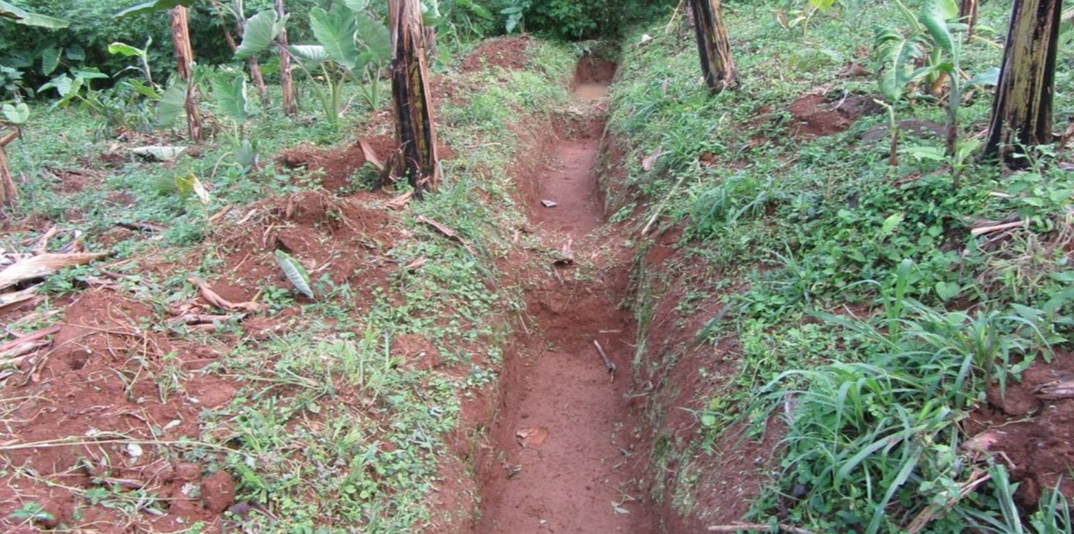
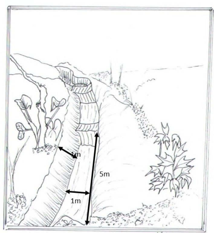
Trenches (Joseline Kashagama)

Runoff Water Harvesting Contour Trenches and Pits in Hilly areas (Uganda)

Zimbibilo

Description

A contour trench and pit are an excavated ditch/pit along a uniform level across the slope of land in the top portion of catchment to trap runoff water.

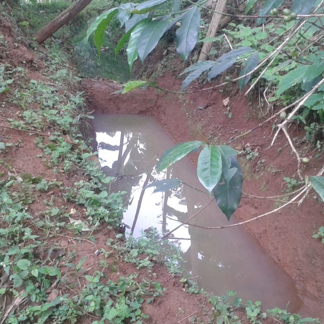
Water harvesting is the deliberate collection and storage of water that runs off on natural or manmade catchment areas. Catchment includes rooftops, compounds, rocky surface or hill slopes or artificially prepared impervious/ semi-pervious land surface. The amount of water harvested depends on the frequency and intensity of rainfall, catchment characteristics, water demands and how much runoff occurs. Contour trenches and pits are one of the oldest and most commonly used water management systems in the hilly areas of Mbale district. Contour trenches and pits are ditches dug along a hillside and run perpendicular to the flow of water. Their main objective is to slow down and attract runoff water which infiltrates into the soil which is used as soil moisture for crop cultivated after a rainfall event.These trenches and pits are constructed and maintained during the dry season. The size of the trenches is based on the slope and soil type. Bulabuli subcounty in Mbale district being a hilly area has trenches which are 5 metres long and 1 metre in width and depth. The materials needed in the construction of the trenches and pits are a hoe and spade. For maintenance they should be checked for build up soil, leaves and branches before the rainy season.The major advantages of rainwater harvesting are that it is simple, cheap, replicable, efficient, sustainable and adaptable and can be applied on any soil type and terrain. It can be implemented in small-scale, easily maintained and requires low investements which suites the rural community in Mbale district. Rainwater harvesting also has been shown an advantage as it reduces soil erosion, improves soil fertility and increases agricultural productivity as it reduces damage on the crops hence increases income and improves livelihood.

Location

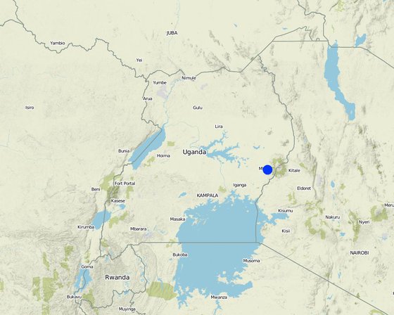
Location: Wahura village, Bunazoma Parish, Wanale subcounty, Eastern Uganda, Uganda

No. of Technology sites analysed: 100-1000 sites

Geo-reference of selected sites
  • 34.2516, 1.0397

Spread of the Technology: evenly spread over an area (approx. 100-1,000 km2)

Date of implementation: 1989; 10-50 years ago

Type of introduction
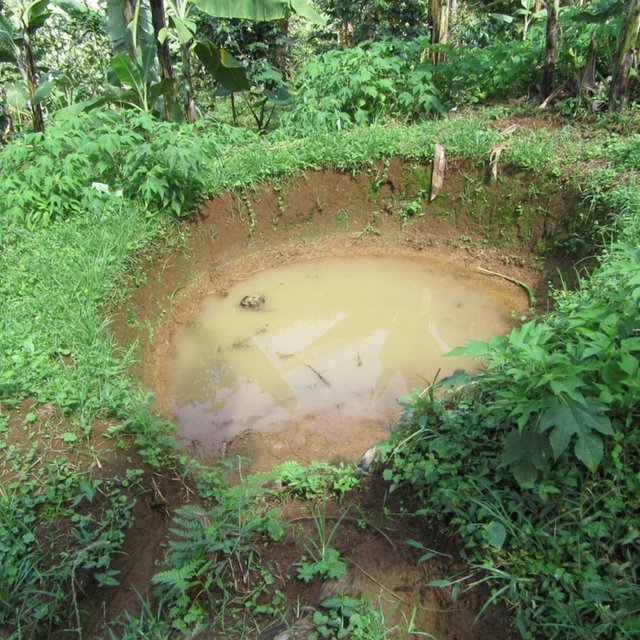
Pits with water (Joseline Kashagama)
Trenches with water (Joseline Kashagama)

Classification of the Technology

Main purpose
  • improve production
  • reduce, prevent, restore land degradation
  • conserve ecosystem
  • protect a watershed/ downstream areas – in combination with other Technologies
  • preserve/ improve biodiversity
  • reduce risk of disasters
  • adapt to climate change/ extremes and its impacts
  • mitigate climate change and its impacts
  • create beneficial economic impact
  • create beneficial social impact
Land use

  • Cropland - Annual cropping, Perennial (non-woody) cropping
    Main crops (cash and food crops): Irish Potatoes, Coffee and bananas
  • Settlements, infrastructure - Settlements, buildings
    Remarks: Land users home

Water supply
  • rainfed
  • mixed rainfed-irrigated
  • full irrigation

Number of growing seasons per year: 2
Land use before implementation of the Technology: n.a.
Livestock density: Cows and goats

Purpose related to land degradation
  • prevent land degradation
  • reduce land degradation
  • restore/ rehabilitate severely degraded land
  • adapt to land degradation
  • not applicable
Degradation addressed
  • soil erosion by water - Wt: loss of topsoil/ surface erosion, Wg: gully erosion/ gullying, Wr: riverbank erosion
  • physical soil deterioration - Pw: waterlogging, Ps: subsidence of organic soils, settling of soil
  • water degradation - Hs: change in quantity of surface water, Hp: decline of surface water quality, Hw: reduction of the buffering capacity of wetland areas
SLM group
  • cross-slope measure
  • water harvesting
  • irrigation management (incl. water supply, drainage)
SLM measures
  • structural measures - S4: Level ditches, pits, S7: Water harvesting/ supply/ irrigation equipment

Technical drawing

Technical specifications
Author: Prossy Kaheru
Trenches of 5metres long and one metre in width and depth while the pits are 4metres deep and 5metres in diameter. The materials needed in the construction of the trenches and pits are a hoe and spade. Contour trenches are dug along a hillside and run perpendicular to the flow of water.

Establishment and maintenance: activities, inputs and costs

Calculation of inputs and costs
  • Costs are calculated: per Technology unit (unit: Trench Line volume, length: Length)
  • Currency used for cost calculation: Ugandan Shilling
  • Exchange rate (to USD): 1 USD = 3600.0 Ugandan Shilling
  • Average wage cost of hired labour per day: 5000
Most important factors affecting the costs
Labour
Establishment activities
  1. Plan according to the topography of the area (Timing/ frequency: Before the on set of rains)
  2. Purchase the materials need (Timing/ frequency: Before the on set of rains)
  3. Measure and indicate (Timing/ frequency: Before the on set of rains)
  4. Construction of the Trenches and pits (Timing/ frequency: Before the on set of rains)
Establishment inputs and costs (per Trench Line)
Specify input Unit Quantity Costs per Unit (Ugandan Shilling) Total costs per input (Ugandan Shilling) % of costs borne by land users
Labour
Man Power Trenches 58.0 4000.0 232000.0
Equipment
Handhoe piece 3.0 10000.0 30000.0
Spade piece 3.0 15000.0 45000.0
Total costs for establishment of the Technology 307'000.0
Maintenance activities
  1. Excavation of soil and other sediments from the trenches (Timing/ frequency: Annually before on set of rains)
Maintenance inputs and costs (per Trench Line)
Specify input Unit Quantity Costs per Unit (Ugandan Shilling) Total costs per input (Ugandan Shilling) % of costs borne by land users
Labour
Labour Trenches 58.0 1500.0 87000.0
Equipment
Handhoe pieces 2.0 10000.0 20000.0
Spade Pieces 2.0 15000.0 30000.0
Total costs for maintenance of the Technology 137'000.0

Natural environment

Average annual rainfall
  • < 250 mm
  • 251-500 mm
  • 501-750 mm
  • 751-1,000 mm
  • 1,001-1,500 mm
  • 1,501-2,000 mm
  • 2,001-3,000 mm
  • 3,001-4,000 mm
  • > 4,000 mm
Agro-climatic zone
  • humid
  • sub-humid
  • semi-arid
  • arid
Specifications on climate
Average annual rainfall in mm: 2064.0
Wanale sub county receives high rainfall because of its high altitude
There's constant flow of streams from the hills which supports agriculture throughout the year
Slope
  • flat (0-2%)
  • gentle (3-5%)
  • moderate (6-10%)
  • rolling (11-15%)
  • hilly (16-30%)
  • steep (31-60%)
  • very steep (>60%)
Landforms
  • plateau/plains
  • ridges
  • mountain slopes
  • hill slopes
  • footslopes
  • valley floors
Altitude
  • 0-100 m a.s.l.
  • 101-500 m a.s.l.
  • 501-1,000 m a.s.l.
  • 1,001-1,500 m a.s.l.
  • 1,501-2,000 m a.s.l.
  • 2,001-2,500 m a.s.l.
  • 2,501-3,000 m a.s.l.
  • 3,001-4,000 m a.s.l.
  • > 4,000 m a.s.l.
Technology is applied in
  • convex situations
  • concave situations
  • not relevant
Soil depth
  • very shallow (0-20 cm)
  • shallow (21-50 cm)
  • moderately deep (51-80 cm)
  • deep (81-120 cm)
  • very deep (> 120 cm)
Soil texture (topsoil)
  • coarse/ light (sandy)
  • medium (loamy, silty)
  • fine/ heavy (clay)
Soil texture (> 20 cm below surface)
  • coarse/ light (sandy)
  • medium (loamy, silty)
  • fine/ heavy (clay)
Topsoil organic matter content
  • high (>3%)
  • medium (1-3%)
  • low (<1%)
Groundwater table
  • on surface
  • < 5 m
  • 5-50 m
  • > 50 m
Availability of surface water
  • excess
  • good
  • medium
  • poor/ none
Water quality (untreated)
  • good drinking water
  • poor drinking water (treatment required)
  • for agricultural use only (irrigation)
  • unusable
Is salinity a problem?
  • Yes
  • No

Occurrence of flooding
  • Yes
  • No
Species diversity
  • high
  • medium
  • low
Habitat diversity
  • high
  • medium
  • low

Characteristics of land users applying the Technology

Market orientation
  • subsistence (self-supply)
  • mixed (subsistence/ commercial
  • commercial/ market
Off-farm income
  • less than 10% of all income
  • 10-50% of all income
  • > 50% of all income
Relative level of wealth
  • very poor
  • poor
  • average
  • rich
  • very rich
Level of mechanization
  • manual work
  • animal traction
  • mechanized/ motorized
Sedentary or nomadic
  • Sedentary
  • Semi-nomadic
  • Nomadic
Individuals or groups
  • individual/ household
  • groups/ community
  • cooperative
  • employee (company, government)
Gender
  • women
  • men
Age
  • children
  • youth
  • middle-aged
  • elderly
Area used per household
  • < 0.5 ha
  • 0.5-1 ha
  • 1-2 ha
  • 2-5 ha
  • 5-15 ha
  • 15-50 ha
  • 50-100 ha
  • 100-500 ha
  • 500-1,000 ha
  • 1,000-10,000 ha
  • > 10,000 ha
Scale
  • small-scale
  • medium-scale
  • large-scale
Land ownership
  • state
  • company
  • communal/ village
  • group
  • individual, not titled
  • individual, titled
Land use rights
  • open access (unorganized)
  • communal (organized)
  • leased
  • individual
Water use rights
  • open access (unorganized)
  • communal (organized)
  • leased
  • individual
Access to services and infrastructure
health

poor
good
education

poor
good
technical assistance

poor
good
employment (e.g. off-farm)

poor
good
markets

poor
good
energy

poor
good
roads and transport

poor
good
drinking water and sanitation

poor
good
financial services

poor
good

Impacts

Socio-economic impacts
Crop production
decreased
increased


Reduced crop failure due to soil and water conservation

risk of production failure
increased
decreased


The soil is kept moist and it is a source of water for the crops after rains.

land management
hindered
simplified


Promotes soil and water conservation and salinity of low ground water bodies through control of soil erosion.

farm income
decreased
increased


Through increased crop production hence increased sales

diversity of income sources
decreased
increased


Source of on farm income to those who provide labour in the digging of the trenches and pits

Socio-cultural impacts
food security/ self-sufficiency
reduced
improved


Increased productivity due to reduced crop failure

SLM/ land degradation knowledge
reduced
improved


Through knowledge sharing in their farmer groups

conflict mitigation
worsened
improved


Reduced soil erosion hence reduced land slides

Ecological impacts
surface runoff
increased
decreased


Reduced sheet erosion as a result of trenches trapping runoff water

soil moisture
decreased
increased


Water is trapped in the trenches which infiltrates into the soil and also used for irrigation

soil loss
increased
decreased


Soil is trapped in the trenches and also reduced soil erosion through reduced water runoff

soil accumulation
decreased
increased


Soil trapped in the trenches is removed and put into the field

salinity
increased
decreased


Reduces salinity of water bodies due to reduced soil erosion

soil organic matter/ below ground C
decreased
increased


Soil cover or mulch and top soil are conserved

biomass/ above ground C
decreased
increased


Ground cover is conserved since sheet erosion is controlled

flood impacts
increased
decreased


Controls flooding to low lands since some water is diverted into the trenches and pits

landslides/ debris flows
increased
decreased


Reduced land slides since water is trapped in the trenches and also the water speed is reduced

drought impacts
increased
decreased


Water trapped in the trenches and pits is used for crop irrigation

Off-site impacts
water availability (groundwater, springs)
decreased
increased


Water trapped in the trenches and pits can be used for spraying and making organic manure mixture from animals

downstream flooding (undesired)
increased
reduced


Water is trapped in the trenches hence reduced runoff and water logging in low areas

downstream siltation
increased
decreased


Soil is trapped in the trenches

groundwater/ river pollution
increased
reduced


Soil erosion is controlled hence controlled salinity of water souces

damage on neighbours' fields
increased
reduced


Run off water is trapped hence reduced erosion and flooding in low land areas

damage on public/ private infrastructure
increased
reduced


Controlled soil erosion reduces land slides which would have blocked the roads affecting the transport system and maintenance costs

Cost-benefit analysis

Benefits compared with establishment costs
Short-term returns
very negative
very positive

Long-term returns
very negative
very positive

Benefits compared with maintenance costs
Short-term returns
very negative
very positive

Long-term returns
very negative
very positive

The trenches maintained after two rainy seasons and readily available cheap labour hence low maintenance cost.

Climate change

Gradual climate change
annual temperature increase

not well at all
very well
annual rainfall decrease

not well at all
very well
seasonal rainfall decrease

not well at all
very well
Season: wet/ rainy season
Climate-related extremes (disasters)
general (river) flood

not well at all
very well
landslide

not well at all
very well
Other climate-related consequences
extended growing period

not well at all
very well
reduced growing period

not well at all
very well

Adoption and adaptation

Percentage of land users in the area who have adopted the Technology
  • single cases/ experimental
  • 1-10%
  • 10-50%
  • more than 50%
Of all those who have adopted the Technology, how many have done so without receiving material incentives?
  • 0-10%
  • 10-50%
  • 50-90%
  • 90-100%
Has the Technology been modified recently to adapt to changing conditions?
  • Yes
  • No
To which changing conditions?
  • climatic change/ extremes
  • changing markets
  • labour availability (e.g. due to migration)

Conclusions and lessons learnt

Strengths: land user's view
  • Reduces soil erosion
  • Improves agricultural productivity through infiltration of the water collected in the trenches and pits
  • water can be used for irrigation and spraying after rains
Strengths: compiler’s or other key resource person’s view
  • Prevents pollutants from draining into the low land water bodies
  • Reduces salinity of ground water
Weaknesses/ disadvantages/ risks: land user's viewhow to overcome
  • Trenches silt up and need regular maintenance Regular maintenance
  • Accidents may occur through drawning Controlled movement of children
  • The trenches and pits are habitats for mosquitoes
Weaknesses/ disadvantages/ risks: compiler’s or other key resource person’s viewhow to overcome
  • Increases land fragmentation since these trenches divide the land into small pieces of land

References

Compiler
  • JOSELINE KASHAGAMA
Editors
Reviewer
  • Nicole Harari
  • Maximilian Knoll
  • Yacime Khadraoui
Date of documentation: March 22, 2018
Last update: July 9, 2018
Resource persons
Full description in the WOCAT database
Linked SLM data
Documentation was faciliated by
Institution Project
Key references
  • Importance of Continuous Contour Trenches (CCT) in Maharashtra by Nitin Bajirao Borse M.V.P.Samaj’s (2016) Arts, Science and Commerce College, Ozar (MIG) Affiliated to SP Pune University: https://www.researchgate.net/publication/308666186_Importance_of_Continuous_Contour_Trenches_CCT_in_Maharashtra
Links to relevant information which is available online
This work is licensed under Creative Commons Attribution-NonCommercial-ShareaAlike 4.0 International