Delfino plow digging micro bassins (Lindo Grandi)

Vallerani System (Burkina Faso)

Description

A special tractor-pulled plow that constructs micro-catchments. It combines the traditional techniques of rainwater harvesting with mechanization for large scale land rehabilitation.

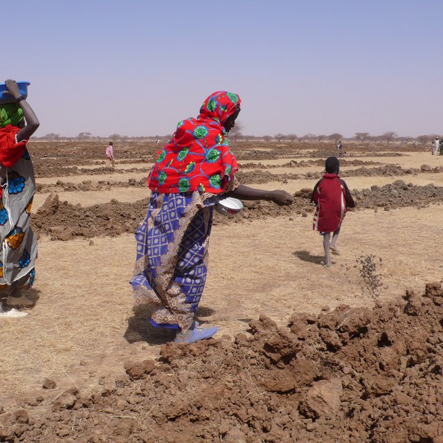
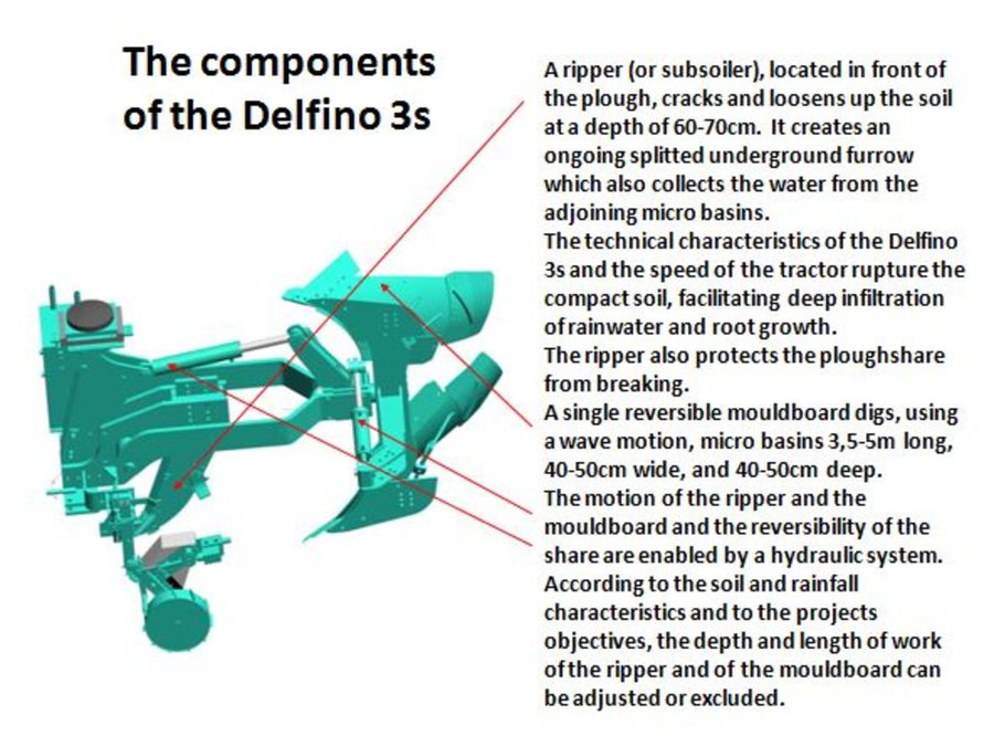
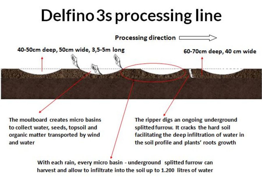
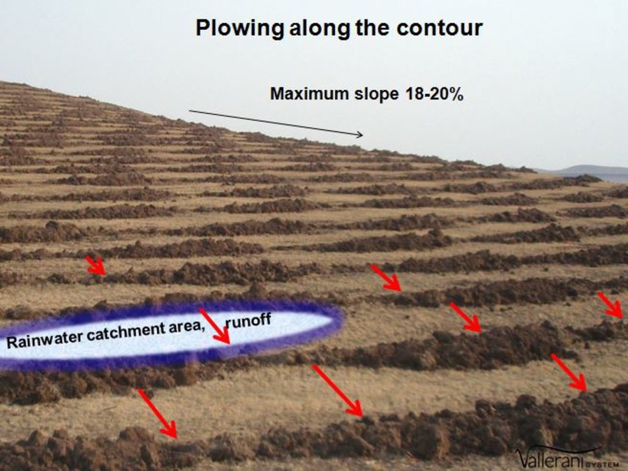
The Technology mechanizes the traditional technique of zai and semi circular bunds for water harvesting using a modified plow named Delfino3s pulled by a 180hp tractor. A normal plow on flat land excavates a symmetrical, continuous furrow, and earth piles up equally on both sides of the furrow. The Delfino3s plow has a single reversible plowshare that creates an angled furrow and piles up the excavated soil in half moon shaped ridges only on the downhill side. The plowing must be done along the contour to collect and slows down runoff water as it flows downhill. The plow’s blade moves in and out of the soil creating micro basins about 5 meters long, 50 cm deep, 50 cm wide and spaced 2-3 m. The ripper placed before the plow cracks up the soil to a depth of 70 cm facilitating the infiltration of water into the soil profile and the growth of deep roots. After plowing, the local population sows seeds of plants of indigenous species. They are sown along the ridges of the basins and in the furrow of the ripper. While for most species seeds are collected by the local population, for species rarely present in the region, seeds are purchased from tree nurseries. Sowing the manure of goat containing seeds has also been very successful with about 95% of all micro basin having at least one tree growing. The intervention on a big scale, the effects of water infiltration in depth, erosion reduction and vegetation growth, boost a long lasting rehabilitation process. Each day the Delfino plow can plow up to 20 ha, digging 6.000-7.000 micro basins. The speed, the capability to plow hard, abbandoned land, the effectiveness of the Delfino3s plow are its major advantages for the ecosystem rehabilitation process but require a big commitment. To make the best out of it, a great motivation and organizational work is necessary to: find great availability of land; train accuratelly the technicians; have well-rooted Subjects in the region. The technological aspect is just part of the recovery process, an important work with the Communities is required upstream and downstream. Communities are involved in the management process – in identifying the areas to be restored, clarifying the land uses of the affected areas, planning and implementing e.g. gathering and keeping seeds of local ecotypes, sowing, in the management of plantations and in the monitoring and evaluation of the results. Rules for SLM are adopted and respected by all. The Technology is applied in a degraded agro-sylvo-pastoral area of the Sahel Region, in the north east of Burkina Faso with 200-500 mm of annual rainfall. The soil is sandy-loam, strongly degraded with surface crust. The population is mainly composed of semi-nomadic herders. At the beginning of the project, the NGO Reach Italia was promoting schooling; they soon realized that during the dry season most kids left school and that to avoid it they should face food security and pasture improvement. So they started applying the Vallerani System and developped the participatory approach. The vegetation growth reduces the need for fodder search and long-range transhumance which also allows children to go to school regularly.The ecosystem rehabilitation effect of the technology help the communities to become more concious and resilient to the effects of climate change and prepared to cope with the socio-economic-environmental changes they are faced with.

Location

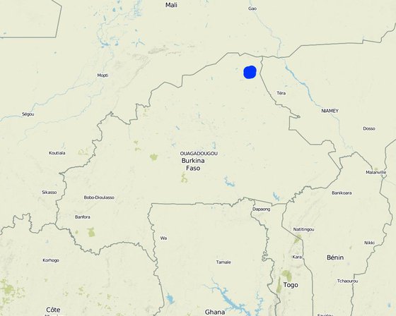
Location: Sahel Region, Burkina Faso

No. of Technology sites analysed: 10-100 sites

Geo-reference of selected sites
  • -0.073, 14.61707
  • -0.08643, 14.61319
  • -0.15407, 14.52775
  • -0.08555, 14.53118
  • -0.13956, 14.52615
  • -0.15697, 14.59569

Spread of the Technology: evenly spread over an area (25.6 km²)

In a permanently protected area?:

Date of implementation: 10-50 years ago

Type of introduction
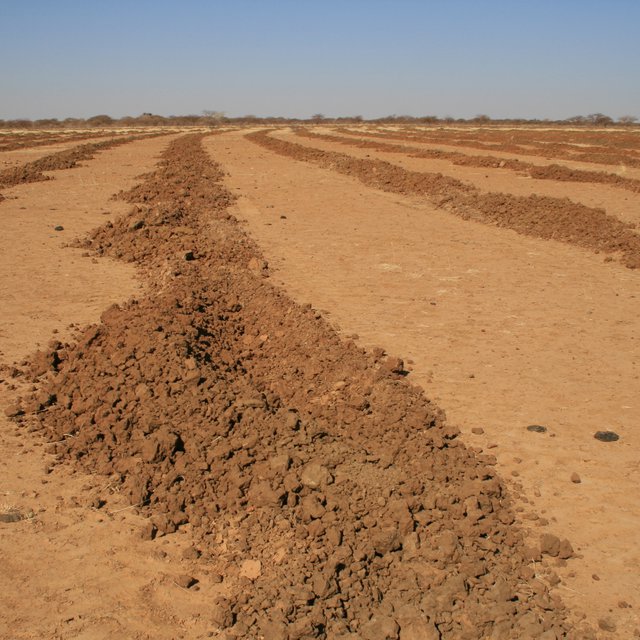
Degraded field after plowing. (Lindo Grandi)
Local people sowing indigenous trees and shrubs seeds in the tilled lines. Sowing days are important and joyful events for the communities. (Lindo Grandi)

Classification of the Technology

Main purpose
  • improve production
  • reduce, prevent, restore land degradation
  • conserve ecosystem
  • protect a watershed/ downstream areas – in combination with other Technologies
  • preserve/ improve biodiversity
  • reduce risk of disasters
  • adapt to climate change/ extremes and its impacts
  • mitigate climate change and its impacts
  • create beneficial economic impact
  • create beneficial social impact
Land use
Land use mixed within the same land unit: Yes - Silvo-pastoralism

  • Grazing land
    • Semi-nomadic pastoralism
    • Improved pastures
    Animal type: cattle - non-dairy beef, goats
  • Forest/ woodlands
    • Tree plantation, afforestation
    Tree types: Acacia albida, Acacia senegal, Acacia seyal, Acacia tortilis, Balanites aegyptiaca, Ziziphus mauritiana
  • Unproductive land - Specify: Hard abbandoned land
    Remarks: Especially at the beginning of the project, some communities agreed to try the system on their most unproductive land. After seeing the results, they started to request the intervention on less degraded soil and on fields that are closer to their villages.

Water supply
  • rainfed
  • mixed rainfed-irrigated
  • full irrigation

Purpose related to land degradation
  • prevent land degradation
  • reduce land degradation
  • restore/ rehabilitate severely degraded land
  • adapt to land degradation
  • not applicable
Degradation addressed
  • soil erosion by water - Wt: loss of topsoil/ surface erosion, Wg: gully erosion/ gullying, Wo: offsite degradation effects
  • soil erosion by wind - Et: loss of topsoil, Eo: offsite degradation effects
  • chemical soil deterioration - Cn: fertility decline and reduced organic matter content (not caused by erosion)
  • physical soil deterioration - Pc: compaction, Pk: slaking and crusting, Pu: loss of bio-productive function due to other activities
  • biological degradation - Bc: reduction of vegetation cover, Bh: loss of habitats, Bq: quantity/ biomass decline, Bs: quality and species composition/ diversity decline, Bl: loss of soil life
  • water degradation - Ha: aridification, Hg: change in groundwater/aquifer level
SLM group
  • agroforestry
  • pastoralism and grazing land management
  • water harvesting
SLM measures
  • agronomic measures - A1: Vegetation/ soil cover, A3: Soil surface treatment, A4: Subsurface treatment
  • vegetative measures - V1: Tree and shrub cover, V2: Grasses and perennial herbaceous plants
  • structural measures - S2: Bunds, banks, S4: Level ditches, pits
  • management measures - M1: Change of land use type, M2: Change of management/ intensity level, M3: Layout according to natural and human environment

Technical drawing

Technical specifications
Drawing 1) A. The land chosen together with the local population is plowed with the special Delfino3s plow. The spacing between the plowed lines depend on: slope, soil and rain characteristics, purpose of the project. In average the inter-line is 4-6m wide. B. Local people sow seeds (collected from local trees or bought if species are rare) or goat dung containing seeds (collected in the night enclosures after feeding the goats shaking trees with ripe seeds). C. The micro basins collect the rain that falls into the crescents and up to 90% of the runoff water. The water easily penetrates into the soil profile, remains available to plant roots without risk of evaporation and eventually infiltrates to the groundwater.
Author: Patrizia Kolb
Drawing 2) All plowing measures are adjustable. Total length of work: 4/8 m. Tractor required: 180hp. Working speed: 4/7 Km/h which correspond to 1,5/2.5ha per hour. Weight of the plough: 1800 Kg.
Author: Sabina Vallerani
Drawing 3) To optimize run off harvesting and reduce water erosion, the ploughing must always be done along the contour. The bare soil between the tilled lines works as catchment area for the collection of runoff. To facilitate the execution of the plowing along the contour, nowadays there are new technologies such as laser guidance systems or GPS assistence.
Author: Sabina Vallerani

Establishment and maintenance: activities, inputs and costs

Calculation of inputs and costs
  • Costs are calculated: per Technology area (size and area unit: 100 hectares)
  • Currency used for cost calculation: USD
  • Exchange rate (to USD): 1 USD = n.a
  • Average wage cost of hired labour per day: 2.5
Most important factors affecting the costs
Upfront costs for the aquisition of the required implements are around 40,000 EUR for the plow and 75,000 EUR for the tractor. Depending on the maintenance activities, the spares and fuel costs can be reduced. Fuel, oil and spares also greatly depend from the characteristics of the soil and the purpose of the project.
Establishment activities
  1. Project planning, consulting and training (Timing/ frequency: Before starting)
  2. Plowing with the Delfino plow (Timing/ frequency: Dry season)
  3. Seed harvesting and storage (Timing/ frequency: When seeds are ripe)
  4. Missing seeds purchase in local markets or nurseries (Timing/ frequency: When seeds are ripe)
  5. Direct sowing (Timing/ frequency: Dry season)
Establishment inputs and costs (per 100 hectares)
Specify input Unit Quantity Costs per Unit (USD) Total costs per input (USD) % of costs borne by land users
Labour
Equipment
Maintenance activities
  1. Pasture management to avoid overgrazing (Timing/ frequency: After the rain and in the dry season)
  2. Vegetation growth management (Timing/ frequency: During the first 3-5 years)
  3. Woodcut management (Timing/ frequency: After 4-7 years)
  4. Equipment maintenance (plow, tactor) (Timing/ frequency: Daily, weekly, seasonal)

Natural environment

Average annual rainfall
  • < 250 mm
  • 251-500 mm
  • 501-750 mm
  • 751-1,000 mm
  • 1,001-1,500 mm
  • 1,501-2,000 mm
  • 2,001-3,000 mm
  • 3,001-4,000 mm
  • > 4,000 mm
Agro-climatic zone
  • humid
  • sub-humid
  • semi-arid
  • arid
Specifications on climate
Dry season from oktober to may, rainy season from june to september. There's a great climate variability with unexpeced dry periods or areas in the rainy season. In the last years climate change effects are experienced in the region with raise in temperature, droughts and rain variability increase. Some Community claim that since the rehabilitation of big degraded areas it rains more regularly and abbundant.
Name of the meteorological station: Dori, Burkina Faso
Thermal climate class: subtropics. Average temperature 30°C
Slope
  • flat (0-2%)
  • gentle (3-5%)
  • moderate (6-10%)
  • rolling (11-15%)
  • hilly (16-30%)
  • steep (31-60%)
  • very steep (>60%)
Landforms
  • plateau/plains
  • ridges
  • mountain slopes
  • hill slopes
  • footslopes
  • valley floors
Altitude
  • 0-100 m a.s.l.
  • 101-500 m a.s.l.
  • 501-1,000 m a.s.l.
  • 1,001-1,500 m a.s.l.
  • 1,501-2,000 m a.s.l.
  • 2,001-2,500 m a.s.l.
  • 2,501-3,000 m a.s.l.
  • 3,001-4,000 m a.s.l.
  • > 4,000 m a.s.l.
Technology is applied in
  • convex situations
  • concave situations
  • not relevant
Soil depth
  • very shallow (0-20 cm)
  • shallow (21-50 cm)
  • moderately deep (51-80 cm)
  • deep (81-120 cm)
  • very deep (> 120 cm)
Soil texture (topsoil)
  • coarse/ light (sandy)
  • medium (loamy, silty)
  • fine/ heavy (clay)
Soil texture (> 20 cm below surface)
  • coarse/ light (sandy)
  • medium (loamy, silty)
  • fine/ heavy (clay)
Topsoil organic matter content
  • high (>3%)
  • medium (1-3%)
  • low (<1%)
Groundwater table
  • on surface
  • < 5 m
  • 5-50 m
  • > 50 m
Availability of surface water
  • excess
  • good
  • medium
  • poor/ none
Water quality (untreated)
  • good drinking water
  • poor drinking water (treatment required)
  • for agricultural use only (irrigation)
  • unusable
Water quality refers to:
Is salinity a problem?
  • Yes
  • No

Occurrence of flooding
  • Yes
  • No
Species diversity
  • high
  • medium
  • low
Habitat diversity
  • high
  • medium
  • low

Characteristics of land users applying the Technology

Market orientation
  • subsistence (self-supply)
  • mixed (subsistence/ commercial)
  • commercial/ market
Off-farm income
  • less than 10% of all income
  • 10-50% of all income
  • > 50% of all income
Relative level of wealth
  • very poor
  • poor
  • average
  • rich
  • very rich
Level of mechanization
  • manual work
  • animal traction
  • mechanized/ motorized
Sedentary or nomadic
  • Sedentary
  • Semi-nomadic
  • Nomadic
Individuals or groups
  • individual/ household
  • groups/ community
  • cooperative
  • employee (company, government)
Gender
  • women
  • men
Age
  • children
  • youth
  • middle-aged
  • elderly
Area used per household
  • < 0.5 ha
  • 0.5-1 ha
  • 1-2 ha
  • 2-5 ha
  • 5-15 ha
  • 15-50 ha
  • 50-100 ha
  • 100-500 ha
  • 500-1,000 ha
  • 1,000-10,000 ha
  • > 10,000 ha
Scale
  • small-scale
  • medium-scale
  • large-scale
Land ownership
  • state
  • company
  • communal/ village
  • group
  • individual, not titled
  • individual, titled
Land use rights
  • open access (unorganized)
  • communal (organized)
  • leased
  • individual
Water use rights
  • open access (unorganized)
  • communal (organized)
  • leased
  • individual
Access to services and infrastructure
health

poor
good
education

poor
good
technical assistance

poor
good
employment (e.g. off-farm)

poor
good
markets

poor
good
energy

poor
good
roads and transport

poor
good
drinking water and sanitation

poor
good
financial services

poor
good

Impacts

Socio-economic impacts
Crop production
decreased
increased

Quantity before SLM: None
Quantity after SLM: 2-4 times
Crop production and biomass augmented 2-4 times compared with traditional cultural techniques.

fodder production
decreased
increased

Quantity before SLM: 90kg/MS/ha
Quantity after SLM: 1250kg/MS/ha
Grass fodder production increased by a factor of 5–30 compared with unmanaged land. The production of herbaceous biomass varied from 420 kg to 2.090 kg (dry matter) per ha; thus, on average, 1.250 kg of herbaceous biomass (dry matter) per ha developed on sites where the Vallerani system was deployed, compared with an average of 90 kg (dry matter) per ha in control plots. Vegetation is mainly distributed inside and around the micro basins.

fodder quality
decreased
increased

Quantity before SLM: 12 floral species
Quantity after SLM: 44 floral species
The application of the Technology boosts a regenaration process increasing year by year. Compared to the surrounding control rangelands, fodder quality and biodiversity increased with a high proportion of grassland species of good forage value, such as Panicum laetum and Schonefeldia gracilis, and the return of legume species such as Alysicarpus ovalifolius and Zornia glochidiata also testify the improvement of the quality of the reconstituted pastures.

animal production
decreased
increased


The increase of fodder quantity and quality represents a surplus of 22–106 grazing days per tropical cattle unit per hectare. This extra fodder supply reduces the need to make long-range transhumance or cut shrubs to meet livestock needs for fodder, even in years where pasture is low. Livestock is fed with more and better quality fodder so its productivity and market price increase.

wood production
decreased
increased

forest/ woodland quality
decreased
increased

Quantity before SLM: 20 trees/ha of 6 species
Quantity after SLM: 700 trees/ha of 14 species
Significant improvement in forest cover (700 live trees and shrubbs per ha, on average) and biodiversity: trees are capable of spontaneous growth even with open access to grazing and in years of high water stress.

non-wood forest production
decreased
increased


Berries, gum arabica, resins, fruits.

risk of production failure
increased
decreased


The increased fodder quantity, quality and biodiversity, the deep root system of the sown plants, increase resilience of the ecosystem and reduce the risk of production failure. The increased biodiversity, soil moisture and fertility increase the resilience of plants to attacks by pests, deseases and drought. Even in the case of severe drought, there are some plants that can be used as "emergency food" by humans and animals.

product diversity
decreased
increased


The implementation of the Technology gives the opportunity to diversify the production. Next to animal breeding, agriculture has intensified and in some villages the production of handicrafts, food processing, hunting and tourism activities are developping. Berries, gum arabica, resins, fruits enrich the family diet or can be sold at markets. Wild animals, insects, reptiles and birds have returned after decades and greatelly increased.

production area (new land under cultivation/ use)
decreased
increased

Quantity before SLM: None
Quantity after SLM: 25.600ha
By the end of 2017 about 25.600 hectares of severelly degraded, abbandoned land has been rehabilitated.

drinking water availability
decreased
increased


Local people attest that the rehabilitation of large areas of bare soil augmented the local rain amount and the water level in the wells.

water availability for livestock
decreased
increased


The rain collected in the micro basins is available for livestock during the rainy season. The augmented rainfall also increases water availability in boulies (ponds).

demand for irrigation water
increased
decreased


No water is needed for the Technology except for rain.

expenses on agricultural inputs
increased
decreased


The implementation cost of the technology is not entirelly sustainable by Communities. donors and founders sustain the project. Large-scale application reduces the cost per hectare and increases the impact of actions in reversing the degradation–desertification trend. The cost of each plowed hectare.

farm income
decreased
increased


Fodder increase in quality and quantity, improve animal health and productivity as well as their market price.

diversity of income sources
decreased
increased


The Technology increases income for herders and their families also thanks to diversification. More land is also used for agriculture. Selling or transformation of other products such as berries, fruits, gums, resins; hunting; new job opportunities in disadvantaged areas such as tractor drivers, social promoters, seed collectors...The community raises awareness and a potential for small business activities occurs, mainly among women.

economic disparities
increased
decreased


Disadvantaged groups such as women start new economic activities such as mat production and sale at markets, medical plants and food production. They diversify their income and improve their status in the community.

workload
increased
decreased

Quantity before SLM: 5 micro basins/day
Quantity after SLM: 6.000 micro basins/day
Each man can dig 5 micro basins per day doing a heavy work. The plow can dig 6.000-7.000 micro basins per day. As most rangelands, the area of the project has a low human density (29 inhabitants/km2) so people are responsible for seed collection and storage, sowing, the livestock management during the first growing phase, monitoring activities, a.s.o.

Migration
Reduced
Increased


Increased and improved fodder availability reduces the need for long-range tranhumance and seasonal or definitive migration to areas with more work opportunities (e.g. mines), cities or other countries.

Socio-cultural impacts
food security/ self-sufficiency
reduced
improved


Food security improves with increased and diversified productivity and income. The increased fodder and crop quantity, quality and biodiversity, the deep root system and soil fertility, increase the resilience of the whole ecosystem. Even in the case of severe drought, there are some plants that can be used as "emergency food" by humans and animals.

health situation
worsened
improved


Improved health especially due to better nutrition also for disadvantaged groups such as children and old people: bigger amounts, diversification, milk, vegetables. The reduction of dust storms also improves the health situation.

land use/ water rights
worsened
improved


Awareness rising and discussion of the theme are essential. Due to the great productivity of former degraded and often abandoned land, land use rules and water rights are clearly discussed and defined at the beginning of the project. Rules for SLM are adopted and respected by all; for example, it is forbidden to install camps in or near restored areas, to cut trees, and to mow for commercial purposes.

recreational opportunities
reduced
improved


Shadow, green areas near the villages increase recreational opportunities.

community institutions
weakened
strengthened


It is essential to involve and give responsibility to local people in every step of the process. Comities and groups such as the women or seniors groups gain relevance and become essential for the sustainability of the project.

national institutions
weakened
strengthened


Collaborations with national institutions such as forestry direction, ministery of environnement and agricolture, research institutes, etc

SLM/ land degradation knowledge
reduced
improved


All communities are involved in the management process – identifying the areas and the use of the sites to be restored, planning, and implementing (e.g. gathering and keeping seeds of local ecotypes, manure and sowing). Local villages are involved in the care and defence of new plantations and in the monitoring and evaluation of the results of vegetation growth. Ultimatelly they become responsable for the sustainable management of the whole area.

conflict mitigation
worsened
improved


If land use and water rights are clearly defined, the increased availability of fodder reduces conflicts with neighbours and farmers.

situation of socially and economically disadvantaged groups (gender, age, status, ehtnicity etc.)
worsened
improved

Community well being
worsened
improved


People have more confidence in the future, dignity and hope. The Community cohesion and identity is strenghtened and the community becomes more resilient to conflicts and disasters.

Ecological impacts
water quantity
decreased
increased

Quantity before SLM: None
Quantity after SLM: 360.000l/ha
With each rain, each micro basin can collect up to 1.200l of water. Each hectare collects an average of 360.000 liter of rain, runoff included. Collected in the micro basin, the water has enough time to infiltrate in the soil profile and eventually in the water table. Local people assert that after the implementation of the Technology, the water level in the wells has raised.

harvesting/ collection of water (runoff, dew, snow, etc)
reduced
improved


The Technology allows to harvest 100% of the rain falling in the micro basin and on the ripped furrow as well as up to 90% of the rain falling between the tilled lines. The bare soil between the tilled lines is essential as catchment area, to recieve rainfall and process runoff downstream. The micro basins collect up to 95% of rainfall.

surface runoff
increased
decreased

Quantity before SLM: 5-15%
Quantity after SLM: 90%
Plowing is done along the contour. This is essential to collect the runoff that flows between the tilled lines (catchment area). The distance between the lines can be between 4m and 12m depending from: slope, rain characteristics (quantity, intensity), soil type, surface roughness (runoff coheficient), the purpose of the project (type of plants desired). The technology allows to collect up to 90% of the runoff.

groundwater table/ aquifer
lowered
recharge


Local people assert that after the implementation of the technology, the water level in the wells has raised.

evaporation
increased
decreased


The rain collected in the micro basins infiltrates in the soil profile being accessible for seeds and roots without evaporating. After the first rains, the micro basins are quickly covered with high grasses that contribute to reduce evaporation.

soil moisture
decreased
increased


Improved soil hydrodynamic properties: the relative size of capillaries by different soil levels increased and the soil water-retaining capability improved.

soil cover
reduced
improved

soil loss
increased
decreased


Reduced soil loss through runoff reduction and wind erosion.

soil compaction
increased
reduced

Quantity before SLM: 423
Quantity after SLM: 70
At different depth soil compactness reduces from 6 (0 to 20cm) to 1.3 times (40 to 60cm)

nutrient cycling/ recharge
decreased
increased

soil organic matter/ below ground C
decreased
increased

vegetation cover
decreased
increased


Vegetation cover increase 5 to 30 times. Vegetation grows mainly inside and around the micro basins.

biomass/ above ground C
decreased
increased

Quantity before SLM: 70 to 110kg/MS/ha
Quantity after SLM: 420 to 2090 kg/MS/ha
The biomass production increases 5 to 30 times compared to the nearby unplowed soil. On implemented sites, biomass varies from 420 to 2090 kg / DM / ha, on average between 1000 and 1200 kg / ha against 70 to 110kg / DM / ha on control plots.

plant diversity
decreased
increased

Quantity before SLM: 14 herbaceous, 6 woody species/ha
Quantity after SLM: 44 herbaceous, 14 woody species/ha
Floral diversity increases from 14 to 44 species. With a high proportion of graminaceous species of good forage value and the return of more leguminous species. Concerning the diversity of woody plants the results show an average per hectare of 14 species on implemented sites and an average of 6 species on control plots.

animal diversity
decreased
increased


A great increase of animal biodiversity: insects, birds, reptiles and mammals (such as squirrel, jackals, gazelle...) are observed in the implemented sites.

pest/ disease control
decreased
increased


The increased vegetal and animal biodiversity, deep root system, soil fertility and water availability, increase the health and resilience capacity of the whole ecosystem.

flood impacts
increased
decreased


Through water harvesting the rain is retained in the precipitation area and flood risk decreases. If flood occurs in the plowed area before the vegetation is well established, the micro basins can be washed out.

drought impacts
increased
decreased


Increased biodiversity, vegetation cover and soil fertility, deep root system and water storage in the soil profile, increase the resilience to drought of the whole ecosystem. During the project, in years of extreme drought, plants have reduced their growth but most of them survived, were used to feed animals and started growing again in the following rainy season.

emission of carbon and greenhouse gases
increased
decreased


Minimal production of carbon dioxide compared with the potential gain.

fire risk
increased
decreased


The implementing area remains open to lifestock (regulated pasture) to reduce the high production of grass that could favor the spread of a fire, herders also monitor the territory. There is a high level of community involvement and a growing ecological awareness.

wind velocity
increased
decreased


The great number of growing trees reduce the wind speed.

micro-climate
worsened
improved


Local people attest that the Technology locally increased the amount of rain and reduced dust storms in number and intensity.

Off-site impacts
water availability (groundwater, springs)
decreased
increased


Local people tell that the rehabilitation of large areas of bare soil augmented the local rain amount and the water level in the wells.

wind transported sediments
increased
reduced


Wind intensity and dust storms reduction thanks to soil coverage and wind brake effect by trees and shrubs.

Cost-benefit analysis

Benefits compared with establishment costs
Short-term returns
very negative
very positive

Long-term returns
very negative
very positive

Benefits compared with maintenance costs
Short-term returns
very negative
very positive

Long-term returns
very negative
very positive

The system includes the use of a heavy duty tractor and a special plow whose costs are high though difficult to sustain by the local population. Most financial costs are covered by founders and donors, the land user's partecipate to the project with their work so even if the benefits in the short term are fewer than in the mid and long-term, for them it is still very positive.

Climate change

Gradual climate change
annual temperature increase

not well at all
very well
seasonal temperature increase

not well at all
very well
Season: dry season
annual rainfall decrease

not well at all
very well
seasonal rainfall decrease

not well at all
very well
Season: wet/ rainy season
Climate-related extremes (disasters)
local rainstorm

not well at all
very well
local sandstorm/ duststorm

not well at all
very well
local windstorm

not well at all
very well
flash flood

not well at all
very well
insect/ worm infestation

not well at all
very well

Adoption and adaptation

Percentage of land users in the area who have adopted the Technology
  • single cases/ experimental
  • 1-10%
  • 11-50%
  • > 50%
Of all those who have adopted the Technology, how many have done so without receiving material incentives?
  • 0-10%
  • 11-50%
  • 51-90%
  • 91-100%
Number of households and/ or area covered
330 villages and around 33.000 beneficiaries
Has the Technology been modified recently to adapt to changing conditions?
  • Yes
  • No
To which changing conditions?
  • climatic change/ extremes
  • changing markets
  • labour availability (e.g. due to migration)
  • technical
The design of the plow has been adapted to increase the performance of the implement and reduce the running costs of plowing. The reversibility of the plowshare reduces the need for empty rides. The different parts of the plow are adjustable to adapt it to the needs of the project and the soil characteristics.

Conclusions and lessons learnt

Strengths: land user's view
  • Higly degraded, abandoned land becomes fertile and rentable again. Fodder increases in quantity and improves in quality and lasts all year round. Food security also in drought years. Herds are healthier and more productive. Fodder and water availability for animals is closer to the villages. Some plants can be sown for different uses: crops, medicine or for the production of mats or other handcrafts products that can be sold.
  • Better life conditions, more income opportunities and diversification. Food is diversified and more nutritious. Less hunger and deseases.
  • Greater community cohesion and less migration, better environnemental conciousness and commitment, education and security. People gain back dignity, confidence in the future and hope.
Strengths: compiler’s or other key resource person’s view
  • The Technology allows the rehabilitation of rangeland and highly degraded areas in a fast and natural way on a large scale. This can boost a longlasting effect and the shift of the whole ecosystem. The Technology confers drought resilience and reduces the effects of climate change. It allows the sequestration of CO2 and can contribute to achieve the Land Degradation Neutrality Goals.
  • The partecipatory approach is essential for the sustainability of the project. The local Communities improve their life quality, awareness, cohesion and resilience. The need for migration is reduced and people has the chance to stay in their Lands.
  • The sown tree and shrub species are mainly indigenous and locally adapted species. Each specie can follow it's own growing laws and adaptation strategies. Through the tillage process the technology offers the highest degree of efficiency in the first years from processing. Its effects last for a long time so it does not need to be repeated on the same site.
  • The VS does not use any water (except rain) in countries where water is rare and precious.
  • The use of a mechanized implement allows to rehabilitate very hard, degraded and abbandoned land on large areas with reduced population. As the Delfino3s can plow strongly degraded land, the local people often ask to work their worse land which they would never be able to use.
Weaknesses/ disadvantages/ risks: land user's viewhow to overcome
  • Land that was unproductive and nobody claimed becomes productive: it can lead to misunderstandigs and conflicts. Land use and production exploitation rules must be cleared and accepted by all Subjects at the beginning of the project.
  • Good pasture attracts animals and herders from the nearby Region (also from far away and abroad). Rules must be clear.
Weaknesses/ disadvantages/ risks: compiler’s or other key resource person’s viewhow to overcome
  • The investmentand running costs for the machinery are high and cannot be covered by single land users or small Communities. The projects must be financed by donors or founders. The Community can partecipate to some extent to cover the running costs.
  • The speed and effectiveness of the Delfino3s plow are its major advantages in the ecosystem rehabilitation process but can also be its major limitation. To make the best out of it, it is necessary to have a great availability of land (1.000-1.800ha) every year. A big organizational capacity is needed. The spreading "like wildfire" that has characterized the case study was possible by the presence on the territory of an NGO already active and rooted in the territory for many years and by perseverance, respect and competence of all involved subjects.
  • Since great extentions will be processed, a big organisation is needed for all connected activities (awareness raising, seed collection and stockage, training, logistics, etc), Must be well organized and should operate already before starting with plowing.
  • The professional level of the tractor drivers and the mechanics as well as the lack of a well-organized mechanical workshop and spares stock can lead to long interruptions of the work and high extra costs. Professional technical trainings and monitoring are very important. The organization of a well managed mechanical workshop and spares stock are essential. This can also be a great development opportunity for the Region.
  • The increased amount of fodder can induce the shepherds to increase the number of animals. An important work with the Communities is essential to achieve shared and sustainable management goals.

References

Compiler
  • Sabina Galli Vallerani
Editors
Reviewer
  • Brigitte Zimmermann
  • Rima Mekdaschi Studer
  • Donia Mühlematter
  • Alexandra Gavilano
Date of documentation: May 3, 2012
Last update: March 8, 2019
Resource persons
Full description in the WOCAT database
Linked SLM data
Documentation was faciliated by
Institution Project
Key references
  • Un "delfino" rinverdisce i deserti, Venanzio Vallerani, ISBN 978-88-95858-05-0: info@vallerani.com
Links to relevant information which is available online
This work is licensed under Creative Commons Attribution-NonCommercial-ShareaAlike 4.0 International