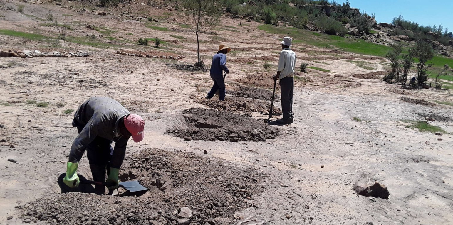
Infiltration pits constructed on bare land to improve land cover, land productivity and soil organic carbon. Leribe district. (Koetlisi Koetlisi)

In-field rain water harvesting (Lesotho)

Infiltration pits

Description

The infiltration pits are constructed on bare lands with the aim to enhance re-vegetation of plant species. The pits help to reduce soil erosion/land degradation as water is now able to infiltrate through the pits because they are constructed in succession. It also improves land productivity and cover as well as soil organic carbon.

The technology is applied on natural marginal environment where the land is dry, they pits are mostly dug on the rangeland. The purpose is to harvest rain water/surface runoff consequently recharge soil moisture and support plant available water as highly as possible. After some time, there will be regeneration of vegetation. The dimensions of this structure may differ according to soil type, slope and rainfall intensity.
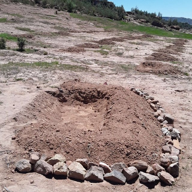
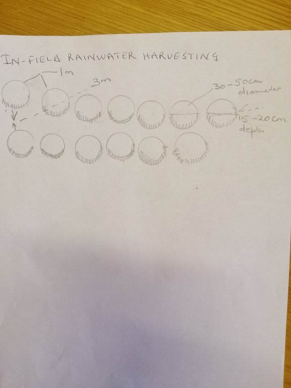
To construct this activity, the land should be bare or poor in plant biodiversity. Firstly, the extension workers hold public gatherings for a concerned community to make them aware of the land degradation in their area and possible solutions. In field rain water harvesting pits being one of them. The area is then surveyed using survey equipment (this is a technical survey not the one which uses questionnaires, this survey uses equipment such as theodolyte, auto cat etc). It is important to do the area survey because the technology follows the contour lines, otherwise it is likely to cause more harm on the land. The design of the technology is laid out by using the measuring tape, pick axe and spade. Construction starts from the top of field. Pits are dug in succession in a row following the contour with in row (intrarow) spacing of 1 m, pit depth of 20-30 cm and width of 1 m. Interrow spacing (between rows) is 3 m at 12% slope. After construction, kikuyu grass is sown around the pits to protect them from erosion. After the first storm, the area is then revisited for maintenance and repairs if need be. This technology is beneficial mostly in drylands where the water shortage is a major problem to improve land productivity. Although specififications are in this manner, this technology can be adapted differently in other areas depending on the amount of precipitation received by a certain area. For instance, some pits can be bigger or smaller than the given specifications.
The land users found it beneficial because the inputs needed to construct this technology are locally available such as spade, pick axe and grass for sodding. Furthermore, the rehabilitation benefits accrue within a short while. In addition, the technology is easy to construct. However, the land users found it tedious as they have to maintain it after every storm. The pits can be constructed on the rangeland and cropland which is no longer productive. in this era of climate change where this part of Southern Africa is becoming more dry everyday, this technology is even more applicable.

Location

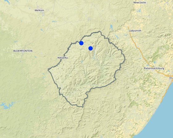
Location: Peri-Urban, Leribe District, Lesotho

No. of Technology sites analysed: single site

Geo-reference of selected sites
  • 28.06666, -28.90601
  • 28.3578, -29.04825

Spread of the Technology: applied at specific points/ concentrated on a small area

In a permanently protected area?: No

Date of implementation: 2019

Type of introduction
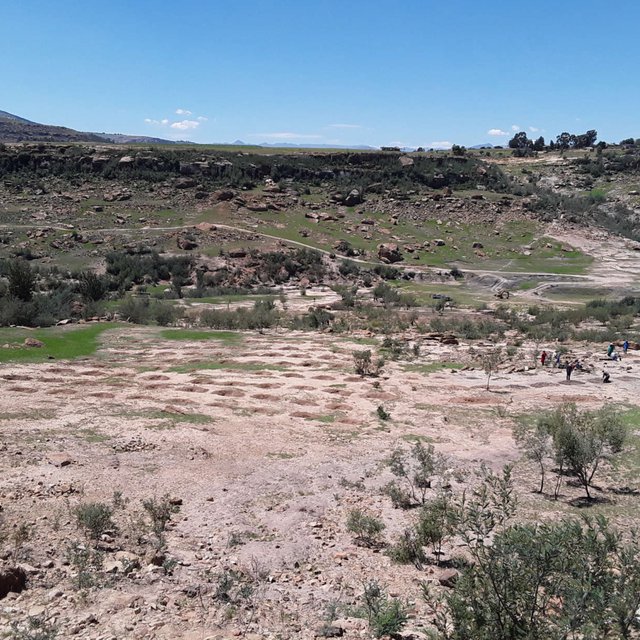
Overview of area constructed with infiltration pits in one of the catchments, Likhakeng Ha-Mahlomola Leribe (Matoka Moshoeshoe)
Full details of a constructed infiltration pit. Stone layering is used to support the walls of the pits and to discourage erosion (Koetlisi Koetlisi)

Classification of the Technology

Main purpose
  • improve production
  • reduce, prevent, restore land degradation
  • conserve ecosystem
  • protect a watershed/ downstream areas – in combination with other Technologies
  • preserve/ improve biodiversity
  • reduce risk of disasters
  • adapt to climate change/ extremes and its impacts
  • mitigate climate change and its impacts
  • create beneficial economic impact
  • create beneficial social impact
Land use
Land use mixed within the same land unit: Yes - Silvo-pastoralism

  • Grazing land
    • Semi-nomadic pastoralism
    • deferred grazing
    Animal type: livestock - other small
    Is integrated crop-livestock management practiced? No
    Products and services: transport/ draught
      SpeciesCount
      cattle - non-dairy beef207
      sheep1307
    • Forest/ woodlands
      • Tree plantation, afforestation: subtropical dry forest plantation. Varieties: Monoculture exotic variety
      Tree types (mixed deciduous/ evergreen): Acacia species, Acacia dealbata
      Products and services: Fuelwood
    • Settlements, infrastructure - Settlements, buildings
      Remarks: settlement encroachment into range-lands

    Water supply
    • rainfed
    • mixed rainfed-irrigated
    • full irrigation

    Purpose related to land degradation
    • prevent land degradation
    • reduce land degradation
    • restore/ rehabilitate severely degraded land
    • adapt to land degradation
    • not applicable
    Degradation addressed
    • soil erosion by water - Wt: loss of topsoil/ surface erosion, Wg: gully erosion/ gullying, Wm: mass movements/ landslides, Wr: riverbank erosion
    • chemical soil deterioration - Cn: fertility decline and reduced organic matter content (not caused by erosion), Cs: salinization/ alkalinization
    • physical soil deterioration - Pc: compaction, Pk: slaking and crusting, Pi: soil sealing, Pw: waterlogging, Pu: loss of bio-productive function due to other activities
    • biological degradation - Bc: reduction of vegetation cover, Bh: loss of habitats, Bq: quantity/ biomass decline, Bf: detrimental effects of fires, Bs: quality and species composition/ diversity decline, Bl: loss of soil life
    • water degradation - Ha: aridification, Hp: decline of surface water quality
    SLM group
    • natural and semi-natural forest management
    • pastoralism and grazing land management
    • water diversion and drainage
    SLM measures
    • agronomic measures - A1: Vegetation/ soil cover, A2: Organic matter/ soil fertility, A6: Residue management
    • vegetative measures - V2: Grasses and perennial herbaceous plants, V4: Replacement or removal of alien/ invasive species
    • structural measures - S3: Graded ditches, channels, waterways, S4: Level ditches, pits
    • management measures - M1: Change of land use type, M2: Change of management/ intensity level, M5: Control/ change of species composition

    Technical drawing

    Technical specifications
    Technical specifications:
    Dimensions; height 20cm, depth 30cm, width 1m and length 1m
    Spacing between structures; between rows 5m, between pits 3m
    slope; 3-12%
    construction material used; stones, soil, grass sodds , mulch and compost and grass seeds
    6 litres is the water holding capacity of a pit
    Author: Matoka Moshoeshoe, Koetlisi Koetlisi and Mamofota Lekholoane

    Establishment and maintenance: activities, inputs and costs

    Calculation of inputs and costs
    • Costs are calculated: per Technology area (size and area unit: 0.2 ha; conversion factor to one hectare: 1 ha = N/A)
    • Currency used for cost calculation: USD
    • Exchange rate (to USD): 1 USD = n.a
    • Average wage cost of hired labour per day: 4.6 US dollars
    Most important factors affecting the costs
    Government annual budget affects inputs and labour
    Establishment activities
    1. public awareness raising gathering (Timing/ frequency: winter)
    2. survey of area/ terrain (Timing/ frequency: winter)
    3. design and laying out of infiltration pits (Timing/ frequency: winter)
    4. implementation/construction of pits (Timing/ frequency: winter)
    5. sowing (Timing/ frequency: winter and or summer)
    6. maintenance (Timing/ frequency: when need arises)
    Establishment inputs and costs (per 0.2 ha)
    Specify input Unit Quantity Costs per Unit (USD) Total costs per input (USD) % of costs borne by land users
    Labour
    one person person-days 1.0 5.0 5.0 5.0
    Equipment
    pick axe piece 1.0 15.0 15.0
    spade piece 1.0 13.0 13.0
    measuring tape piece 1.0 8.0 8.0
    Plant material
    grass seed kg 2.0 13.0 26.0 25.0
    Construction material
    stones piece 40.0 1.0 40.0
    Total costs for establishment of the Technology 107.0
    Total costs for establishment of the Technology in USD 107.0
    Maintenance activities
    1. public gathering (Timing/ frequency: after storm)
    2. re-survey (Timing/ frequency: after storm)
    3. implementation (Timing/ frequency: after storm)
    Maintenance inputs and costs (per 0.2 ha)
    Specify input Unit Quantity Costs per Unit (USD) Total costs per input (USD) % of costs borne by land users
    Labour
    grass seed kg 1.0 13.0 13.0
    one person person day 1.0 5.0 5.0
    Total costs for maintenance of the Technology 18.0
    Total costs for maintenance of the Technology in USD 18.0

    Natural environment

    Average annual rainfall
    • < 250 mm
    • 251-500 mm
    • 501-750 mm
    • 751-1,000 mm
    • 1,001-1,500 mm
    • 1,501-2,000 mm
    • 2,001-3,000 mm
    • 3,001-4,000 mm
    • > 4,000 mm
    Agro-climatic zone
    • humid
    • sub-humid
    • semi-arid
    • arid
    Specifications on climate
    Average annual rainfall in mm: 735.0
    The Northern parts of the country receive good amount of rainfall generally. This is the place where generally soils are also good and agricultural production is satisfactory so far.
    Name of the meteorological station: Hlotse
    The climate in this region favours agricultural production more than anything else. The Leribe district was once referred to as the bread basket of the country simply because the climate and soils are good for both crop and animal production.
    Slope
    • flat (0-2%)
    • gentle (3-5%)
    • moderate (6-10%)
    • rolling (11-15%)
    • hilly (16-30%)
    • steep (31-60%)
    • very steep (>60%)
    Landforms
    • plateau/plains
    • ridges
    • mountain slopes
    • hill slopes
    • footslopes
    • valley floors
    Altitude
    • 0-100 m a.s.l.
    • 101-500 m a.s.l.
    • 501-1,000 m a.s.l.
    • 1,001-1,500 m a.s.l.
    • 1,501-2,000 m a.s.l.
    • 2,001-2,500 m a.s.l.
    • 2,501-3,000 m a.s.l.
    • 3,001-4,000 m a.s.l.
    • > 4,000 m a.s.l.
    Technology is applied in
    • convex situations
    • concave situations
    • not relevant
    Soil depth
    • very shallow (0-20 cm)
    • shallow (21-50 cm)
    • moderately deep (51-80 cm)
    • deep (81-120 cm)
    • very deep (> 120 cm)
    Soil texture (topsoil)
    • coarse/ light (sandy)
    • medium (loamy, silty)
    • fine/ heavy (clay)
    Soil texture (> 20 cm below surface)
    • coarse/ light (sandy)
    • medium (loamy, silty)
    • fine/ heavy (clay)
    Topsoil organic matter content
    • high (>3%)
    • medium (1-3%)
    • low (<1%)
    Groundwater table
    • on surface
    • < 5 m
    • 5-50 m
    • > 50 m
    Availability of surface water
    • excess
    • good
    • medium
    • poor/ none
    Water quality (untreated)
    • good drinking water
    • poor drinking water (treatment required)
    • for agricultural use only (irrigation)
    • unusable
    Water quality refers to: both ground and surface water
    Is salinity a problem?
    • Yes
    • No

    Occurrence of flooding
    • Yes
    • No
    Species diversity
    • high
    • medium
    • low
    Habitat diversity
    • high
    • medium
    • low

    Characteristics of land users applying the Technology

    Market orientation
    • subsistence (self-supply)
    • mixed (subsistence/ commercial)
    • commercial/ market
    Off-farm income
    • less than 10% of all income
    • 10-50% of all income
    • > 50% of all income
    Relative level of wealth
    • very poor
    • poor
    • average
    • rich
    • very rich
    Level of mechanization
    • manual work
    • animal traction
    • mechanized/ motorized
    Sedentary or nomadic
    • Sedentary
    • Semi-nomadic
    • Nomadic
    Individuals or groups
    • individual/ household
    • groups/ community
    • cooperative
    • employee (company, government)
    Gender
    • women
    • men
    Age
    • children
    • youth
    • middle-aged
    • elderly
    Area used per household
    • < 0.5 ha
    • 0.5-1 ha
    • 1-2 ha
    • 2-5 ha
    • 5-15 ha
    • 15-50 ha
    • 50-100 ha
    • 100-500 ha
    • 500-1,000 ha
    • 1,000-10,000 ha
    • > 10,000 ha
    Scale
    • small-scale
    • medium-scale
    • large-scale
    Land ownership
    • state
    • company
    • communal/ village
    • group
    • individual, not titled
    • individual, titled
    Land use rights
    • open access (unorganized)
    • communal (organized)
    • leased
    • individual
    Water use rights
    • open access (unorganized)
    • communal (organized)
    • leased
    • individual
    Access to services and infrastructure
    health

    poor
    good
    education

    poor
    good
    technical assistance

    poor
    good
    employment (e.g. off-farm)

    poor
    good
    markets

    poor
    good
    energy

    poor
    good
    roads and transport

    poor
    good
    drinking water and sanitation

    poor
    good
    financial services

    poor
    good
    Comments

    The area is found in the peri-urban zone which is near the major town of Hlotse. There are access roads and they are closer to markets.

    Impacts

    Socio-economic impacts
    fodder production
    decreased
    increased

    Quantity before SLM: vegetation cover was poor
    Quantity after SLM: increased vegetation cover
    quantity increased after SLM

    fodder quality
    decreased
    increased

    Quantity before SLM: fodder quality was also poor
    Quantity after SLM: increased quality
    There is now fodder available for animals

    land management
    hindered
    simplified

    Quantity before SLM: land was poorly managed
    Quantity after SLM: community members agreed to protect the land
    The pits constructed have contributed positively to increase in land cover, land productivity and soil organic carbon

    Socio-cultural impacts
    food security/ self-sufficiency
    reduced
    improved

    Quantity before SLM: animals were too weak
    Quantity after SLM: the quality of stock improved
    The technology has contributed positively towards availability of fodder hence good animal production

    recreational opportunities
    reduced
    improved

    Quantity before SLM: biodiversity was lost
    Quantity after SLM: regeneration of biodiversity
    both birds and wild animals are now occupying the habitat, communities use rehabilitated areas as parks or picnic area, and people pay to access that part of the land. The revenue collected will then be used for other purposes that might help community such as fixing a broken water tap etc.

    SLM/ land degradation knowledge
    reduced
    improved

    Quantity before SLM: community members did not have knowledge of the technology
    Quantity after SLM: community members can now construct the pits on their own in their own land
    knowledge on land degradation now improved

    Ecological impacts
    harvesting/ collection of water (runoff, dew, snow, etc)
    reduced
    improved

    Quantity before SLM: water was not collected
    Quantity after SLM: surface run-off was now collected
    a lot of water is now collected through this technology and not lost like it used to be

    surface runoff
    increased
    decreased

    Quantity before SLM: surface runoff was not controlled
    Quantity after SLM: surface run-off was partly collected
    surface run-off now partly collected and soil erosion minimised

    excess water drainage
    reduced
    improved

    Quantity before SLM: poor surface drainage
    Quantity after SLM: infiltration improved drainage
    surface drainage was controlled to enhance infiltration

    soil moisture
    decreased
    increased

    Quantity before SLM: prolonged dry-moist dry
    Quantity after SLM: conditional moisture
    improved

    soil cover
    reduced
    improved

    Quantity before SLM: the land was bare
    Quantity after SLM: revegetation
    improved vegetation abundance

    soil loss
    increased
    decreased

    Quantity before SLM: sheet erosion
    Quantity after SLM: sheet erosion disrupted
    surface roughness improved

    soil accumulation
    decreased
    increased

    Quantity before SLM: much soil loss
    Quantity after SLM: sedimentation improved
    sediment is collected in ditches

    biomass/ above ground C
    decreased
    increased

    Quantity before SLM: bare ground
    Quantity after SLM: above ground biomass improved
    improved soil moisture supports biomass production

    plant diversity
    decreased
    increased

    Quantity before SLM: few species
    Quantity after SLM: species variety
    various species require availed prolonged soil moisture

    Off-site impacts
    impact of greenhouse gases
    increased
    reduced

    Quantity before SLM: less carbon stored in the soil
    Quantity after SLM: improved carbon sequestration
    soil organic carbon improved

    Cost-benefit analysis

    Benefits compared with establishment costs
    Short-term returns
    very negative
    very positive

    Long-term returns
    very negative
    very positive

    Benefits compared with maintenance costs
    Short-term returns
    very negative
    very positive

    Long-term returns
    very negative
    very positive

    the technology can easily be maintained although maintenance plan does not exist

    Climate change

    Gradual climate change
    annual temperature increase

    not well at all
    very well
    seasonal rainfall increase

    not well at all
    very well
    Season: summer
    Climate-related extremes (disasters)
    local thunderstorm

    not well at all
    very well
    local hailstorm

    not well at all
    very well
    flash flood

    not well at all
    very well

    Adoption and adaptation

    Percentage of land users in the area who have adopted the Technology
    • single cases/ experimental
    • 1-10%
    • 11-50%
    • > 50%
    Of all those who have adopted the Technology, how many have done so without receiving material incentives?
    • 0-10%
    • 11-50%
    • 51-90%
    • 91-100%
    Number of households and/ or area covered
    sixty
    Has the Technology been modified recently to adapt to changing conditions?
    • Yes
    • No
    To which changing conditions?
    • climatic change/ extremes
    • changing markets
    • labour availability (e.g. due to migration)
    the dimensions differ relative to the rainfall intensity, soil type and technician and land user preference

    Conclusions and lessons learnt

    Strengths: land user's view
    • the technology is implemented by both men and women
    • Middle-aged and elderly group were impressed with the technology
    • the technology uses locally available inputs
    Strengths: compiler’s or other key resource person’s view
    • it is environmentally friendly
    • it helps in achieving variuos LDN targets
    • it can be demonstrated to a large group of people at once
    Weaknesses/ disadvantages/ risks: land user's viewhow to overcome
    • they could be easily destroyed by single hailstorm trenches be constructed to lower velocity and discharge of surface run-off
    • they could conditionally be filled with sediment sediments should be removed periodically
    Weaknesses/ disadvantages/ risks: compiler’s or other key resource person’s viewhow to overcome
    • they could be easily destroyed by single hailstorm trenches be constructed to lower velocity and discharge of surface run-off

    References

    Compiler
    • Matoka Moshoeshoe
    Editors
    Reviewer
    • Rima Mekdaschi Studer
    • William Critchley
    Date of documentation: March 25, 2019
    Last update: Aug. 12, 2020
    Resource persons
    Full description in the WOCAT database
    Linked SLM data
    Documentation was faciliated by
    Institution Project
    Key references
    • In-field rainwater harvesting: Conservation of your natural resources through in-field rainwater harvesting, Jacobus Botha, [2012]: Agricultureal Research Council, Institute for Soil, Climate and Water (ARC-SCW), South Africa
    Links to relevant information which is available online
    This work is licensed under Creative Commons Attribution-NonCommercial-ShareaAlike 4.0 International