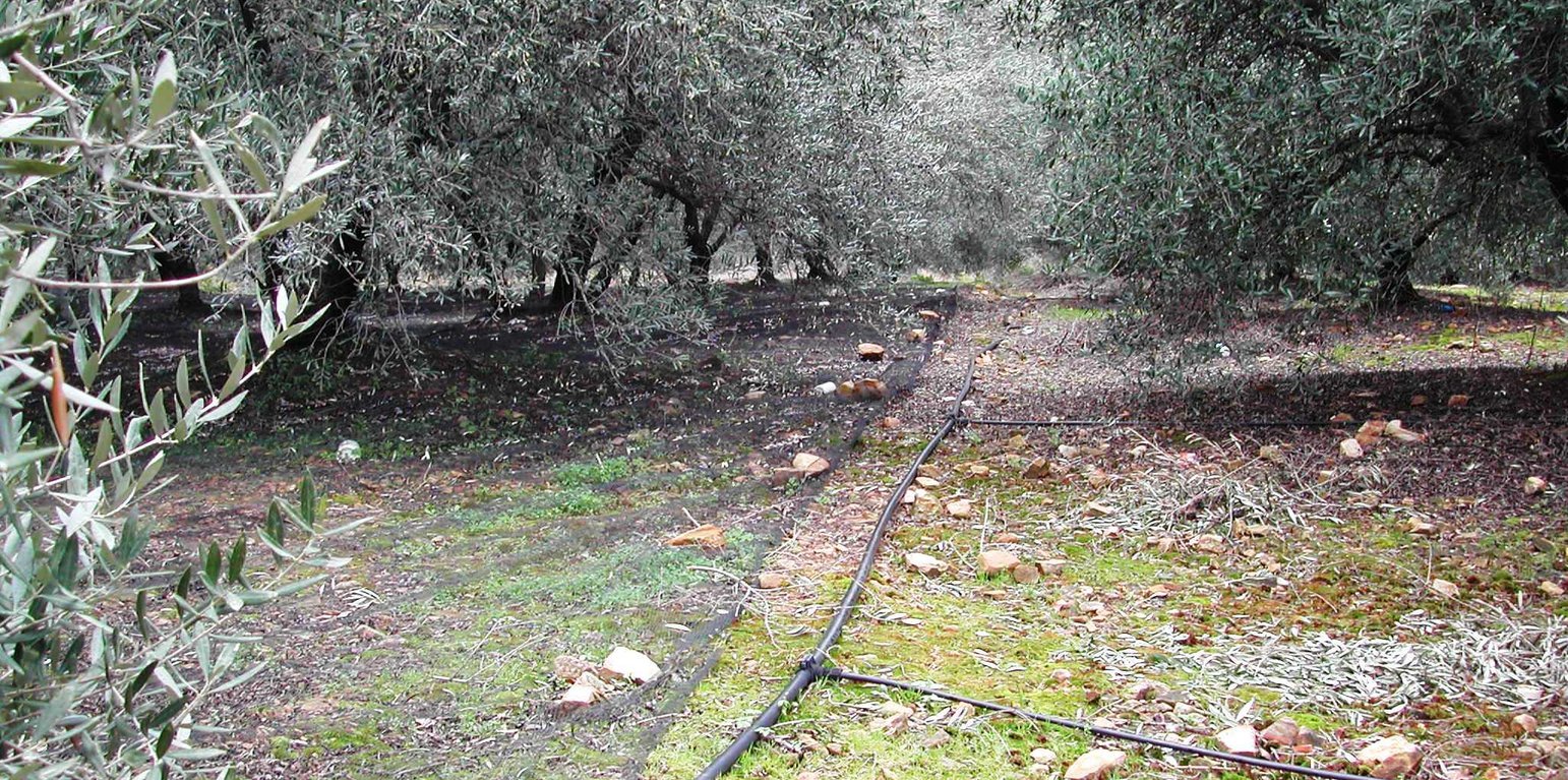
Drip irrigation system applied in olive groves in the area of Chania, Crete (C. Kosmas)

Application of water by drip irrigation (Greece)

Αρδευση με σταγονες

Description

Drip irrigation, also known as trickle irrigation is a method which minimizes the use of water and fertilizer by allowing water to drip slowly to the roots of plants, either onto the soil surface or directly onto the root zone, through a network of valves, pipes, tubing, and emitters.

Irrigation is very important for increasing crop yields in arid, semi-arid and dry sub-humid climates. The area of irrigated land has increased more than twice in the last decades in the study areas. In recent years, the considerable reduction of winter and autumn rainfall has caused a serious lack of water resources. The production of the various crops is substantially reduced if water is not provided during the summer period.
The high demands for water consumption or other economic activities have increased the price of water, forcing up the cost of agricultural production. In addition, in many cases, low quality (with high electrical conductivity) water is used for irrigation. The need for intensification of agriculture to meet the high cost of production, the use of poor quality of water, the lack of drainage systems are in many cases responsible for soil degradation resulting from water logging, salinization, alkalinization, and soil erosion.

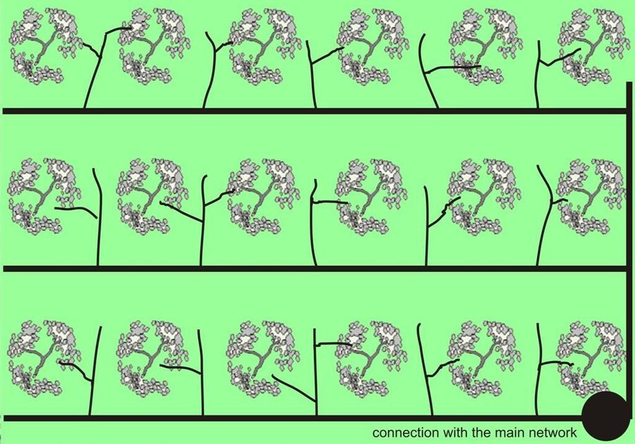
Purpose of the Technology: Drip or trickle irrigation achieves the highest irrigation efficiency since about 90% of the applied water is available to the plants. This SWC technology is especially suitable for watering trees or other large plants keeping strips among trees dry. Application of water by drip irrigation can be considered more as more efficient method using low quality of irrigation water. Irrigation water of high salt content can be applied in higher quantities in spots leaching salts to deeper soil layers. Drip irrigation can be applied in any type of soil from coarse- and fine-textured and without any limitation to slope gradient requiring little labour during installation.

Establishment / maintenance activities and inputs: In the study area of Chania trickle irrigation system includes mainly three branches from the outlet of main water network transportation system to the application in the trees. The last branch consists of plastic tube 12 to 32 mm in diameter that lies either on or just below the soil surface and applies the water either through small holes in the line or through emitter nozzle.

Natural / human environment: In recent years the increasing awareness of farmers on issues relating to the sustainability of the environment and conservation of water by promoting SWC technologies has led to widespread of use of drip irrigation in the area of Crete and in many other parts of the Country. The categorization of the specific SWC technology according to the WOCAT questionnaire is defined as: CtWtA3.

Location

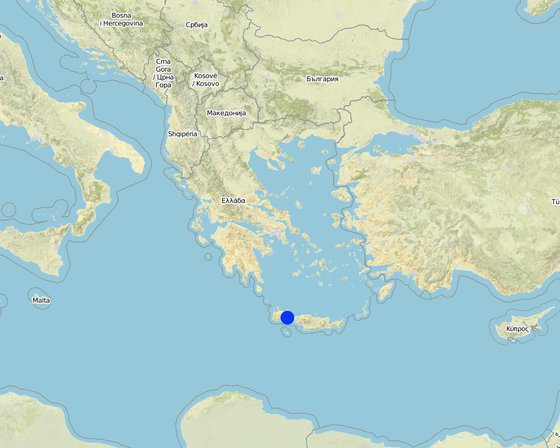
Location: Chania Crete, Kidonia, Greece

No. of Technology sites analysed:

Geo-reference of selected sites
  • 24.1, 35.3333

Spread of the Technology:

In a permanently protected area?:

Date of implementation:

Type of introduction

Classification of the Technology

Main purpose
  • improve production
  • reduce, prevent, restore land degradation
  • conserve ecosystem
  • protect a watershed/ downstream areas – in combination with other Technologies
  • preserve/ improve biodiversity
  • reduce risk of disasters
  • adapt to climate change/ extremes and its impacts
  • mitigate climate change and its impacts
  • create beneficial economic impact
  • create beneficial social impact
Land use

  • Cropland
    • Tree and shrub cropping: olive
Water supply
  • rainfed
  • mixed rainfed-irrigated
  • full irrigation

Purpose related to land degradation
  • prevent land degradation
  • reduce land degradation
  • restore/ rehabilitate severely degraded land
  • adapt to land degradation
  • not applicable
Degradation addressed
  • water degradation - Ha: aridification
SLM group
  • irrigation management (incl. water supply, drainage)
SLM measures
  • agronomic measures - A3: Soil surface treatment
  • structural measures - S11: Others

Technical drawing

Technical specifications
In the study area of Chania trickle irrigation system includes mainly three branches from the outlet of main water network transportation system to the application in the trees. The last branch consists of plastic tube 12 to 32 mm in diameter that lies either on or just below the soil surface and applies the water either through small holes in the line or through emitter nozzles.

Location: Kasteli. Chania

Date: March 2007

Technical knowledge required for land users: moderate (system installation requirements)

Main technical functions: improvement of ground cover

Secondary technical functions: increase in organic matter, increase of biomass (quantity)

In blocks
Vegetative material: C : perennial crops
Number of plants per (ha): 250
Vertical interval between rows / strips / blocks (m): 5
Spacing between rows / strips / blocks (m): 5
Vertical interval within rows / strips / blocks (m): 5
Width within rows / strips / blocks (m): 4

Perennial crops species: olives

Slope (which determines the spacing indicated above): 15.00%

Gradient along the rows / strips: 15.00%

Structural measure: irrigation system
Spacing between structures (m): 8

Construction material (other): plastic, plastic tubes 12-32 mm in diameter

Other type of management: Water distribution among farmers, water is provided under the control of local authorities
Author: C. Kosmas

Establishment and maintenance: activities, inputs and costs

Calculation of inputs and costs
  • Costs are calculated:
  • Currency used for cost calculation: n.a.
  • Exchange rate (to USD): 1 USD = n.a
  • Average wage cost of hired labour per day: n.a
Most important factors affecting the costs
the reguired materials (tubes, filters, etc)
Establishment activities
  1. planting the olive trees (Timing/ frequency: 2 days/ha)
  2. transporting plastic tubes (Timing/ frequency: once during installation)
  3. Whole system of tubes, filters and system of fertilizers application (Timing/ frequency: once during installation)
  4. Main network of irrigation system (Timing/ frequency: once per year)
Establishment inputs and costs
Specify input Unit Quantity Costs per Unit (n.a.) Total costs per input (n.a.) % of costs borne by land users
Labour
>Installation ha 1.0 350.0 350.0
Equipment
Tools ha 1.0 1650.0 1650.0
Total costs for establishment of the Technology 2'000.0
Total costs for establishment of the Technology in USD 2'000.0
Maintenance activities
  1. cleaning filters and replacing destroyied tubes (Timing/ frequency: 3 hours every year/ha)
  2. Checking outlets and conectors (Timing/ frequency: once per year)
  3. Control of network for loss of irrigation water (Timing/ frequency: once per year)
Maintenance inputs and costs
Specify input Unit Quantity Costs per Unit (n.a.) Total costs per input (n.a.) % of costs borne by land users
Labour
Labour ha 1.0 10.0 10.0
Equipment
Tools ha 1.0 50.0 50.0
Total costs for maintenance of the Technology 60.0
Total costs for maintenance of the Technology in USD 60.0

Natural environment

Average annual rainfall
  • < 250 mm
  • 251-500 mm
  • 501-750 mm
  • 751-1,000 mm
  • 1,001-1,500 mm
  • 1,501-2,000 mm
  • 2,001-3,000 mm
  • 3,001-4,000 mm
  • > 4,000 mm
Agro-climatic zone
  • humid
  • sub-humid
  • semi-arid
  • arid
Specifications on climate
With six months of dry period
Thermal climate class: temperate
Slope
  • flat (0-2%)
  • gentle (3-5%)
  • moderate (6-10%)
  • rolling (11-15%)
  • hilly (16-30%)
  • steep (31-60%)
  • very steep (>60%)
Landforms
  • plateau/plains
  • ridges
  • mountain slopes
  • hill slopes
  • footslopes
  • valley floors
Altitude
  • 0-100 m a.s.l.
  • 101-500 m a.s.l.
  • 501-1,000 m a.s.l.
  • 1,001-1,500 m a.s.l.
  • 1,501-2,000 m a.s.l.
  • 2,001-2,500 m a.s.l.
  • 2,501-3,000 m a.s.l.
  • 3,001-4,000 m a.s.l.
  • > 4,000 m a.s.l.
Technology is applied in
  • convex situations
  • concave situations
  • not relevant
Soil depth
  • very shallow (0-20 cm)
  • shallow (21-50 cm)
  • moderately deep (51-80 cm)
  • deep (81-120 cm)
  • very deep (> 120 cm)
Soil texture (topsoil)
  • coarse/ light (sandy)
  • medium (loamy, silty)
  • fine/ heavy (clay)
Soil texture (> 20 cm below surface)
  • coarse/ light (sandy)
  • medium (loamy, silty)
  • fine/ heavy (clay)
Topsoil organic matter content
  • high (>3%)
  • medium (1-3%)
  • low (<1%)
Groundwater table
  • on surface
  • < 5 m
  • 5-50 m
  • > 50 m
Availability of surface water
  • excess
  • good
  • medium
  • poor/ none
Water quality (untreated)
  • good drinking water
  • poor drinking water (treatment required)
  • for agricultural use only (irrigation)
  • unusable
Water quality refers to:
Is salinity a problem?
  • Yes
  • No

Occurrence of flooding
  • Yes
  • No
Species diversity
  • high
  • medium
  • low
Habitat diversity
  • high
  • medium
  • low

Characteristics of land users applying the Technology

Market orientation
  • subsistence (self-supply)
  • mixed (subsistence/ commercial)
  • commercial/ market
Off-farm income
  • less than 10% of all income
  • 10-50% of all income
  • > 50% of all income
Relative level of wealth
  • very poor
  • poor
  • average
  • rich
  • very rich
Level of mechanization
  • manual work
  • animal traction
  • mechanized/ motorized
Sedentary or nomadic
  • Sedentary
  • Semi-nomadic
  • Nomadic
Individuals or groups
  • individual/ household
  • groups/ community
  • cooperative
  • employee (company, government)
Gender
  • women
  • men
Age
  • children
  • youth
  • middle-aged
  • elderly
Area used per household
  • < 0.5 ha
  • 0.5-1 ha
  • 1-2 ha
  • 2-5 ha
  • 5-15 ha
  • 15-50 ha
  • 50-100 ha
  • 100-500 ha
  • 500-1,000 ha
  • 1,000-10,000 ha
  • > 10,000 ha
Scale
  • small-scale
  • medium-scale
  • large-scale
Land ownership
  • state
  • company
  • communal/ village
  • group
  • individual, not titled
  • individual, titled
Land use rights
  • open access (unorganized)
  • communal (organized)
  • leased
  • individual
Water use rights
  • open access (unorganized)
  • communal (organized)
  • leased
  • individual
Access to services and infrastructure
technical assistance

poor
x
good
markets

poor
x
good
roads and transport

poor
x
good
financial services

poor
x
good

Impacts

Socio-economic impacts
Crop production
decreased
x
increased

Quantity before SLM: 1500 kg/ha
Quantity after SLM: 2000 kg/ha

land management
hindered
x
simplified


Cultivation of the land is hindered by the irrigation network

irrigation water availability
decreased
x
increased

irrigation water quality
decreased
x
increased

expenses on agricultural inputs
increased
x
decreased

farm income
decreased
x
increased

Quantity before SLM: 4500 euro/ha
Quantity after SLM: 5800 euro/ha

workload
increased
x
decreased

Socio-cultural impacts
cultural opportunities (eg spiritual, aesthetic, others)
reduced
x
improved

situation of socially and economically disadvantaged groups (gender, age, status, ehtnicity etc.)
worsened
x
improved

Improved livelihoods and human well-being
decreased
x
increased


Significant environmental benefit from the rational use of irrigation water

Ecological impacts
soil moisture
decreased
x
increased

salinity
increased
x
decreased

biomass/ above ground C
decreased
x
increased

Waste
increased
x
decreased


environmental pollution due to presence of plastics not easily recycled

Off-site impacts
water availability (groundwater, springs)
decreased
x
increased

Cost-benefit analysis

Benefits compared with establishment costs
Short-term returns
very negative
x
very positive

Long-term returns
very negative
x
very positive

Benefits compared with maintenance costs
Short-term returns
very negative
x
very positive

Long-term returns
very negative
x
very positive

Climate change

Climate-related extremes (disasters)
general (river) flood

not well at all
x
very well

Adoption and adaptation

Percentage of land users in the area who have adopted the Technology
  • single cases/ experimental
  • 1-10%
  • 11-50%
  • > 50%
Of all those who have adopted the Technology, how many have done so without receiving material incentives?
  • 0-10%
  • 11-50%
  • 51-90%
  • 91-100%
Number of households and/ or area covered
3850
Has the Technology been modified recently to adapt to changing conditions?
  • Yes
  • No
To which changing conditions?
  • climatic change/ extremes
  • changing markets
  • labour availability (e.g. due to migration)

Conclusions and lessons learnt

Strengths: land user's view
  • Increase crop production in some cases up to 50%

    How can they be sustained / enhanced? providing more water
Strengths: compiler’s or other key resource person’s view
  • Technologies on conserving soil and water resources and combating desertification in Crete are mainly related to land management. Olive groves are widely expanded in the island due to the importance of olive oil as one of the essential material for daily human food needs. Furthermore, olive groves can survive under adverse climatic and soil conditions supporting a significant farmer’s income under relatively low labour. Land management practices have been adopted in the area based on tradition and transfer knowledge by the local institutes and specialists.
    In addition, irrigation of the land by the drip system is considered as a very promising technique for conserving water resources in the area. Land terracing is a human intervention in sloping semi-natural landscapes, which have suffered losses, to some degree, in their sustainability and resilience.

    How can they be sustained / enhanced? by providing additional water resources in the area (build a water reservoir)
Weaknesses/ disadvantages/ risks: land user's viewhow to overcome
  • High cost for buying materials, better education subsidizing materials, technology transfer
Weaknesses/ disadvantages/ risks: compiler’s or other key resource person’s viewhow to overcome
  • increased cost for the first installation subsidizing the system

References

Compiler
  • Costas Kosmas
Editors
Reviewer
  • Fabian Ottiger
  • Alexandra Gavilano
Date of documentation: May 11, 2011
Last update: April 2, 2019
Resource persons
Full description in the WOCAT database
Linked SLM data
Documentation was faciliated by
Institution Project
This work is licensed under Creative Commons Attribution-NonCommercial-ShareaAlike 4.0 International