Retention ditch Murang'a
(Kenya)
Nyakinyua
Description
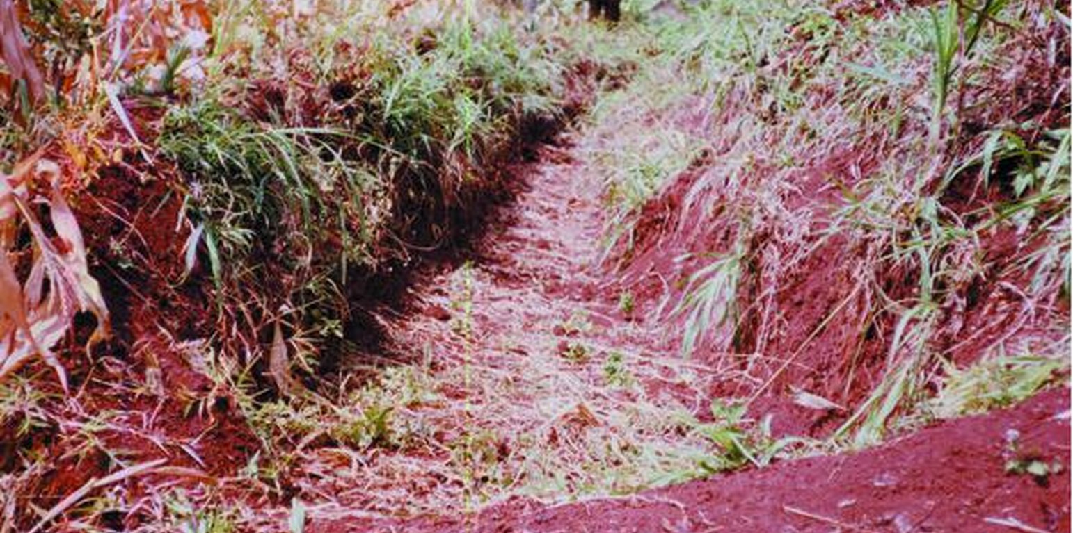
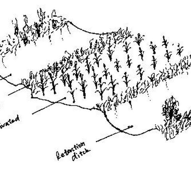
A ditch across the slope for trapping /retaining runoff to encourage infiltration
Constructed at zero gradient with closed ends, wide and deep to hold all expected runoff. The purpose is prevent the concentrated runoff from reaching the cultivated land. It is manually constructed and maintenance is seasonal.It is used where soils are deep , stable and well drained. These structures are unsuitable in areas susceptible to land slides . They are also not very suitable in areas with very deep soils that are not stable.
Location
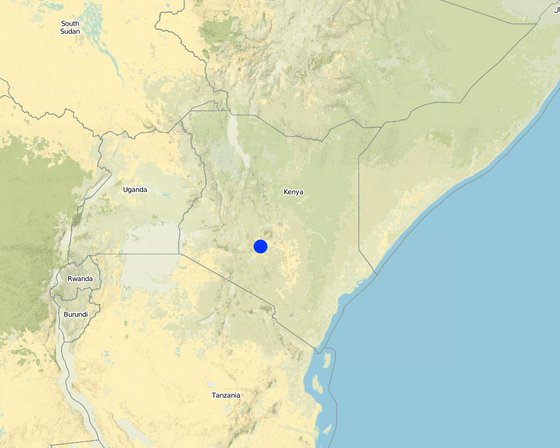
Location: Central, Kenya
No. of Technology sites analysed:
Geo-reference of selected sites
Spread of the Technology: evenly spread over an area (2.5 km²)
In a permanently protected area?:
Date of implementation: less than 10 years ago (recently)
Type of introduction
-
through land users' innovation
-
as part of a traditional system (> 50 years)
-
during experiments/ research
-
through projects/ external interventions
-
Classification of the Technology
Main purpose
-
improve production
-
reduce, prevent, restore land degradation
-
conserve ecosystem
-
protect a watershed/ downstream areas – in combination with other Technologies
-
preserve/ improve biodiversity
-
reduce risk of disasters
-
adapt to climate change/ extremes and its impacts
-
mitigate climate change and its impacts
-
create beneficial economic impact
-
create beneficial social impact
Land use
-
Cropland
- Annual cropping: fodder crops - grasses
- Tree and shrub cropping
Water supply
-
rainfed
-
mixed rainfed-irrigated
-
full irrigation
Purpose related to land degradation
-
prevent land degradation
-
reduce land degradation
-
restore/ rehabilitate severely degraded land
-
adapt to land degradation
-
not applicable
Degradation addressed
-
soil erosion by water - Wt: loss of topsoil/ surface erosion, Wg: gully erosion/ gullying
-
water degradation - Ha: aridification
SLM group
-
water diversion and drainage
SLM measures
-
structural measures - S4: Level ditches, pits
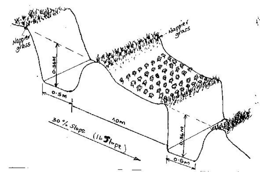
Technical drawing
Technical specifications
Technical knowledge required for field staff / advisors: moderate
Technical knowledge required for land users: low
Main technical functions: control of concentrated runoff: retain / trap, increase of infiltration, water harvesting / increase water supply
Construction material (earth): placed on the lower side of the ditch
Lateral gradient along the structure: 0%
Vegetation is used for stabilisation of structures.
Establishment and maintenance: activities, inputs and costs
Calculation of inputs and costs
- Costs are calculated:
- Currency used for cost calculation: Kenya shilling
- Exchange rate (to USD): 1 USD = 78.0 Kenya shilling
- Average wage cost of hired labour per day: 1.50
Most important factors affecting the costs
labour availability, depth/width of ditch. The cost of labour
Establishment activities
-
excavation (Timing/ frequency: dry spell)
-
planting of grass on the embarkment (Timing/ frequency: on set of rains)
-
(Timing/ frequency: None)
-
(Timing/ frequency: None)
Maintenance activities
-
desilting channel (Timing/ frequency: dry spell/twice per year)
-
gapping the napier grass (Timing/ frequency: wet season/twice per year)
Natural environment
Average annual rainfall
-
< 250 mm
-
251-500 mm
-
501-750 mm
-
751-1,000 mm
-
1,001-1,500 mm
-
1,501-2,000 mm
-
2,001-3,000 mm
-
3,001-4,000 mm
-
> 4,000 mm
Agro-climatic zone
-
humid
-
sub-humid
-
semi-arid
-
arid
Specifications on climate
n.a.
Slope
-
flat (0-2%)
-
gentle (3-5%)
-
moderate (6-10%)
-
rolling (11-15%)
-
hilly (16-30%)
-
steep (31-60%)
-
very steep (>60%)
Landforms
-
plateau/plains
-
ridges
-
mountain slopes
-
hill slopes
-
footslopes
-
valley floors
Altitude
-
0-100 m a.s.l.
-
101-500 m a.s.l.
-
501-1,000 m a.s.l.
-
1,001-1,500 m a.s.l.
-
1,501-2,000 m a.s.l.
-
2,001-2,500 m a.s.l.
-
2,501-3,000 m a.s.l.
-
3,001-4,000 m a.s.l.
-
> 4,000 m a.s.l.
Technology is applied in
-
convex situations
-
concave situations
-
not relevant
Soil depth
-
very shallow (0-20 cm)
-
shallow (21-50 cm)
-
moderately deep (51-80 cm)
-
deep (81-120 cm)
-
very deep (> 120 cm)
Soil texture (topsoil)
-
coarse/ light (sandy)
-
medium (loamy, silty)
-
fine/ heavy (clay)
Soil texture (> 20 cm below surface)
-
coarse/ light (sandy)
-
medium (loamy, silty)
-
fine/ heavy (clay)
Topsoil organic matter content
-
high (>3%)
-
medium (1-3%)
-
low (<1%)
Groundwater table
-
on surface
-
< 5 m
-
5-50 m
-
> 50 m
Availability of surface water
-
excess
-
good
-
medium
-
poor/ none
Water quality (untreated)
-
good drinking water
-
poor drinking water (treatment required)
-
for agricultural use only (irrigation)
-
unusable
Is salinity a problem?
Occurrence of flooding
Characteristics of land users applying the Technology
Market orientation
-
subsistence (self-supply)
-
mixed (subsistence/ commercial)
-
commercial/ market
Off-farm income
-
less than 10% of all income
-
10-50% of all income
-
> 50% of all income
Relative level of wealth
-
very poor
-
poor
-
average
-
rich
-
very rich
Level of mechanization
-
manual work
-
animal traction
-
mechanized/ motorized
Sedentary or nomadic
-
Sedentary
-
Semi-nomadic
-
Nomadic
Individuals or groups
-
individual/ household
-
groups/ community
-
cooperative
-
employee (company, government)
Age
-
children
-
youth
-
middle-aged
-
elderly
Area used per household
-
< 0.5 ha
-
0.5-1 ha
-
1-2 ha
-
2-5 ha
-
5-15 ha
-
15-50 ha
-
50-100 ha
-
100-500 ha
-
500-1,000 ha
-
1,000-10,000 ha
-
> 10,000 ha
Scale
-
small-scale
-
medium-scale
-
large-scale
Land ownership
-
state
-
company
-
communal/ village
-
group
-
individual, not titled
-
individual, titled
Land use rights
-
open access (unorganized)
-
communal (organized)
-
leased
-
individual
Water use rights
-
open access (unorganized)
-
communal (organized)
-
leased
-
individual
Access to services and infrastructure
Impacts
Ecological impacts
surface runoff
Quantity before SLM: 30
Quantity after SLM: 0
soil loss
Quantity before SLM: 150
Quantity after SLM: 15
Cost-benefit analysis
Benefits compared with establishment costs
Short-term returns
very negative
very positive
Long-term returns
very negative
very positive
Benefits compared with maintenance costs
Short-term returns
very negative
very positive
Long-term returns
very negative
very positive
Adoption and adaptation
Percentage of land users in the area who have adopted the Technology
-
single cases/ experimental
-
1-10%
-
11-50%
-
> 50%
Of all those who have adopted the Technology, how many have done so without receiving material incentives?
-
0-10%
-
11-50%
-
51-90%
-
91-100%
Number of households and/ or area covered
387 households in an area of 2.5 sq km
Has the Technology been modified recently to adapt to changing conditions?
To which changing conditions?
-
climatic change/ extremes
-
changing markets
-
labour availability (e.g. due to migration)
Conclusions and lessons learnt
Strengths: land user's view
Strengths: compiler’s or other key resource person’s view
Weaknesses/ disadvantages/ risks: land user's viewhow to overcome
Weaknesses/ disadvantages/ risks: compiler’s or other key resource person’s viewhow to overcome
References
Reviewer
-
David Streiff
-
Alexandra Gavilano
Date of documentation: June 6, 2011
Last update: May 3, 2019
Full description in the WOCAT database
Documentation was faciliated by
Institution
- Ministry of Agriculture and Livestock Development of Kenya (MoA) - Kenya
Project
Key references
-
Murang'a district dev Plan. 2002.: RPD, Ministry of Finance.
-
SWC manual for Kenya. 1997.: MoA/SWCB Nairobi
-
farm management handbook. 1983.: MoA/FMD Nairobi